
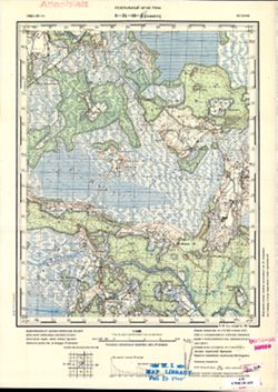
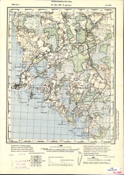
Search Constraints
« Previous |
1 - 10 of 35
|
Next »
Search Results
-
- Description:
- 1902
- Subject:
- Topical Subject: Soviet Union, Geographic Subject: Dūkštas, and Topical Subject: Maps
- Publisher:
- Генеральный штаб РККА
- Language:
- Russian
- Date Created:
- 1904
- Identifier:
- VAC9619-004019
- Genre:
- Topographic Maps and Military Maps
- Geographic Location:
- Coordinates: 55.333, 26, 55.667, 26.5
- Related URL:
- Catalog URL: https://iucat.iu.edu/catalog/5020129 and Download GeoTIFF: https://drive.google.com/file/d/1Y2i0U9df_YhqVhbk8KKYWxodLwUq_OfR/view?usp=sharing
- Abstract:
- Modern area represented: Dūkštas, Utena, Lithuania
- Call Number:
- G7000 s100 .S7 sheet N-35-17
- City:
- Дукшты (Dukszty)
- Copyright Holder:
- No Copyright - United States
- Country:
- Литва (Lithuania) and Польша (Poland)
- Physical Description:
- Scale: 1:100,000
- Persistent URL:
- http://purl.dlib.indiana.edu/iudl/images/VAC9619/VAC9619-004019
- Provenance:
- DMA Topographic Center, Army Map Service Library, OMAHA
-
- Description:
- 1900
- Subject:
- Topical Subject: Soviet Union, Geographic Subject: Kalisz, and Topical Subject: Maps
- Publisher:
- Управление военных топографов РККА
- Language:
- Russian
- Date Created:
- 1904
- Identifier:
- VAC9619-002719
- Genre:
- Military Maps and Topographic Maps
- Geographic Location:
- Coordinates: 51.667, 18, 52, 18.5
- Related URL:
- Download GeoTIFF: https://drive.google.com/file/d/13dLPHy_1H2bOo5hON50kKniZuPrKzI1p/view?usp=sharing and Catalog URL: https://iucat.iu.edu/catalog/5020129
- Abstract:
- Modern area represented: Kalisz, Greater Poland province, Poland
- Call Number:
- G7000 s100 .S7 sheet M-34-1
- City:
- Калиш (Kalisz)
- Copyright Holder:
- No Copyright - United States
- Country:
- Польша (Poland)
- Physical Description:
- Scale: 1:100,000
- Persistent URL:
- http://purl.dlib.indiana.edu/iudl/images/VAC9619/VAC9619-002719
- Provenance:
- CIA Map Library
-
- Description:
- 1902
- Subject:
- Geographic Subject: Mihkli, Topical Subject: Soviet Union, and Topical Subject: Maps
- Publisher:
- Генеральный штаб РККА
- Language:
- Russian
- Date Created:
- 1904
- Identifier:
- VAC9619-001854
- Genre:
- Topographic Maps and Military Maps
- Geographic Location:
- Coordinates: 58.5, 24, 58.667, 24.25
- Related URL:
- Download GeoTIFF: https://drive.google.com/open?id=1IhPfCbugi21-LIDSQwkgO2BgpTYKRl-N and Catalog URL: http://iucat.iu.edu/catalog/5020131
- Abstract:
- Modern area represented: Mihkli, Estonia
- Call Number:
- G7000 s50 .S68 sheet O-35-49-A
- City:
- Михкли (Mihkli)
- Copyright Holder:
- No Copyright - United States
- Country:
- Эстония (Estonia)
- Physical Description:
- Scale: 1:50,000
- Persistent URL:
- http://purl.dlib.indiana.edu/iudl/images/VAC9619/VAC9619-001854
- Provenance:
- Army Map Service Library, OMAHA, Library of Congress Geography & Map Division
-
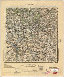
- Description:
- 1902
- Subject:
- Topical Subject: Soviet Union, Topical Subject: Maps, and Geographic Subject: Vigala
- Publisher:
- Генеральный штаб РККА
- Language:
- Russian
- Date Created:
- 1904
- Identifier:
- VAC9619-001849
- Genre:
- Military Maps and Topographic Maps
- Geographic Location:
- Coordinates: 58.667, 24.25, 58.833, 24.5
- Related URL:
- Catalog URL: http://iucat.iu.edu/catalog/5020131 and Download GeoTIFF: https://drive.google.com/open?id=1fUTyInbNtkB8xb224J5owbEj39Op0Nez
- Abstract:
- Modern area represented: Vigala, Estonia
- Call Number:
- G7000 s50 .S68 sheet O-35-37-D
- City:
- Вигала (Vigala)
- Copyright Holder:
- No Copyright - United States
- Country:
- Эстония (Estonia)
- Physical Description:
- Scale: 1:50,000
- Persistent URL:
- http://purl.dlib.indiana.edu/iudl/images/VAC9619/VAC9619-001849
- Provenance:
- M. I. Map Library, GS, RA, G000-30
-
- Description:
- 1902
- Subject:
- Topical Subject: Soviet Union, Geographic Subject: Rabivere, and Topical Subject: Maps
- Publisher:
- Генеральный штаб РККА
- Language:
- Russian
- Date Created:
- 1904
- Identifier:
- VAC9619-001709
- Genre:
- Topographic Maps and Military Maps
- Geographic Location:
- Coordinates: 58.5, 23.75, 58.667, 24
- Related URL:
- Catalog URL: http://iucat.iu.edu/catalog/5020131 and Download GeoTIFF: https://drive.google.com/open?id=11pGtXV0WSHXx8snXge7jLkzd8J-adHGT
- Abstract:
- Modern area represented: Rabivere, Rapla county, Estonia
- Call Number:
- G7000 s50 .S68 sheet O-34-60-B
- City:
- Рабивере (Rabivere)
- Copyright Holder:
- No Copyright - United States
- Country:
- Эстония (Estonia)
- Physical Description:
- Scale: 1:50,000
- Persistent URL:
- http://purl.dlib.indiana.edu/iudl/images/VAC9619/VAC9619-001709
- Provenance:
- M. I. Map Library, GS, RA, CIA Map Library, Atlasblatt
-
- Description:
- 1903
- Subject:
- Topical Subject: Maps, Topical Subject: Soviet Union, and Geographic Subject: Virtsu
- Publisher:
- Генеральный штаб РККА
- Language:
- Russian
- Date Created:
- 1904
- Identifier:
- VAC9619-001708
- Genre:
- Military Maps and Topographic Maps
- Geographic Location:
- Coordinates: 58.5, 23.5, 58.667, 23.75
- Related URL:
- Download GeoTIFF: https://drive.google.com/open?id=1h6nrxgzxSXzBPqAb6ffsW_tqtQKdN23o and Catalog URL: http://iucat.iu.edu/catalog/5020131
- Abstract:
- Modern area represented: Virtsu, Pärnu county, Estonia
- Call Number:
- G7000 s50 .S68 sheet O-34-60-A
- City:
- Виртсу (Virtsu)
- Copyright Holder:
- No Copyright - United States
- Country:
- Эстония (Estonia)
- Physical Description:
- Scale: 1:50,000
- Persistent URL:
- http://purl.dlib.indiana.edu/iudl/images/VAC9619/VAC9619-001708
- Provenance:
- CIA Map Branch -- Received
-
- Description:
- 1902
- Subject:
- Topical Subject: Maps, Topical Subject: Soviet Union, and Geographic Subject: Lihula
- Publisher:
- Генеральный штаб РККА
- Language:
- Russian
- Date Created:
- 1904
- Identifier:
- VAC9619-001692
- Genre:
- Topographic Maps and Military Maps
- Geographic Location:
- Coordinates: 58.667, 23.75, 58.833, 24
- Related URL:
- Catalog URL: http://iucat.iu.edu/catalog/5020131 and Download GeoTIFF: https://drive.google.com/open?id=1W-t21p9l2lq4a6AYJEi47j1FziHIPJPh
- Abstract:
- Modern area represented: Lihula, Lääne county, Estonia
- Call Number:
- G7000 s50 .S68 sheet O-34-48-Г
- City:
- Лихула (Lihula)
- Copyright Holder:
- No Copyright - United States
- Country:
- Эстония (Estonia)
- Physical Description:
- Scale: 1:50,000
- Persistent URL:
- http://purl.dlib.indiana.edu/iudl/images/VAC9619/VAC9619-001692
- Provenance:
- DMA Topographic Center, Army Map Service Library, OMAHA, Library of Congress Geography & Map Division
-
- Description:
- 1903
- Subject:
- Topical Subject: Soviet Union, Topical Subject: Maps, and Geographic Subject: Haeska
- Publisher:
- Генеральный штаб РККА
- Language:
- Russian
- Date Created:
- 1904
- Identifier:
- VAC9619-001690
- Genre:
- Military Maps and Topographic Maps
- Geographic Location:
- Coordinates: 58.667, 23.5, 58.833, 23.75
- Related URL:
- Catalog URL: http://iucat.iu.edu/catalog/5020131 and Download GeoTIFF: https://drive.google.com/open?id=1HY8XbHvi5Ds4E4Vankbvs4BCiOHvTeBT
- Abstract:
- Modern area represented: Haeska, Lääne county, Estonia
- Call Number:
- G7000 s50 .S68 sheet O-34-48-B
- City:
- Хаэска (Haeska)
- Copyright Holder:
- No Copyright - United States
- Country:
- Эстония (Estonia)
- Physical Description:
- Scale: 1:50,000
- Persistent URL:
- http://purl.dlib.indiana.edu/iudl/images/VAC9619/VAC9619-001690
- Provenance:
- DMA Topographic Center, OMAHA, Geographic Names Branch, Army Map Service Library, Library of Congress Geography & Map Division
-
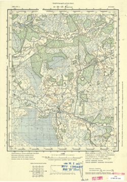
![Map No. 4 showing locations of upper & lower dams [Winona Lake Region, Indiana]](https://iiif.uits.iu.edu/iiif/2/3j3345867%2Ffiles%2Fcfcf70eb-0483-44d3-b9ee-e305909b40f2/full/250,/0/default.jpg)
- Subject:
- Geographic Subject: Kosciusko County (Ind.), Geographic Subject: Winona Lake Region (Ind. : Lake), Topical Subject: IGS Annual Reports, and Topical Subject: ...
- Publisher:
- Indiana. Department of Geology and Natural Resources
- Date Created:
- 1904
- Identifier:
- VAC3073-M-01583
- Genre:
- Topographic maps and Geological cross-sections
- Geographic Location:
- Coordinates: W0855154 W0855032 N0411406 N0411308
- Related URL:
- Catalog URL: https://iucat.iu.edu/catalog/18418357
- Abstract:
- Relief shown by contours and profile. Shows location of dams on Winona Lake outlet near Warsaw in Kosciusko County, Indiana, and cross-sections of upper and ...
- Call Number:
- G4093.K6N2 1903 .M3
- Caption:
- Imprint: [Indianapolis] : [Wm. B. Burford], [1904] and Imprint: [Indianapolis] : [Indiana Department of Geology and Natural Resources], [1904]
- Physical Description:
- Dimensions: on sheet 10 x 10 cm and Scale: Approximately 1:20,100. Vertical scale varies
- Alternate Identifier:
- Title Control Number: a18418357 and Alternate ID: 390726IP
- Persistent URL:
- https://purl.dlib.indiana.edu/iudl/images/VAC3073/VAC3073-M-01583
- Provenance:
- 28th Annual Report (1903) / Indiana. Department of Geology and Natural Resources.
-
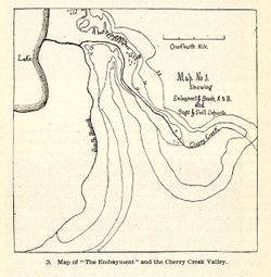
- Subject:
- Topical Subject: IGS Annual Reports, Geographic Subject: Cherry Creek (Ind.), and Topical Subject: Rivers
- Publisher:
- Indiana. Department of Geology and Natural Resources
- Date Created:
- 1904
- Identifier:
- VAC3073-M-01580
- Genre:
- Maps
- Related URL:
- Catalog URL: new.iucat.iu.edu/catalog/4022271
- Call Number:
- QE109 .A2 1903
- Caption:
- Imprint: Indianapolis : 1904.
- Persistent URL:
- https://purl.dlib.indiana.edu/iudl/images/VAC3073/VAC3073-M-01580
- Provenance:
- 28th Annual Report (1903) / Indiana. Department of Geology and Natural Resources.

- « Previous
- Next »
- 1
- 2
- 3
- 4