
Search Constraints
« Previous |
1 - 50 of 297
|
Next »
Search Results
-
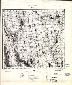
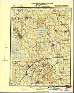
- Description:
- 1853
- Subject:
- Geographic Subject: Laptevo, Topical Subject: Soviet Union, and Topical Subject: Maps
- Publisher:
- Управление военных топографов
- Language:
- Russian
- Date Created:
- 1930
- Identifier:
- VAC9619-001599
- Genre:
- Topographic Maps and Military Maps
- Geographic Location:
- Coordinates: 54.333, 37.573, 54.5, 37.823
- Related URL:
- Catalog URL: http://iucat.iu.edu/catalog/5020131 and Download GeoTIFF: https://drive.google.com/file/d/1aGuqwqLIQb2dh7zU2_a7HtzP9CLQ1XqP/view?usp=sharing
- Abstract:
- Modern area represented: Laptevo, Tula oblast, Russia
- Call Number:
- G7000 s50 .S68 sheet N-37-52-В/Г
- City:
- Ст. Лаптево (Laptevo)
- Copyright Holder:
- No Copyright - United States
- Country:
- СССР (USSR)
- State/Province:
- Московская область (Moscow oblast) and РСФСР (RSFSR)
- Physical Description:
- Scale: 1:50,000
- Persistent URL:
- http://purl.dlib.indiana.edu/iudl/images/VAC9619/VAC9619-001599
- Provenance:
- Army Map Service Library, Library of Congress Geography & Map Division, OMAHA
-
- Description:
- 1929
- Subject:
- Topical Subject: Soviet Union, Geographic Subject: Novyy Barsuk, and Topical Subject: Maps
- Publisher:
- Управление военных топографов
- Language:
- Russian
- Date Created:
- 1930
- Identifier:
- VAC9619-001565
- Genre:
- Military Maps and Topographic Maps
- Geographic Location:
- Coordinates: 52, 30.25, 52.1667, 30.5
- Related URL:
- Download GeoTIFF: https://drive.google.com/open?id=1xAqaU1gE6Y2IhwXoJ_TpZglXYfUyXzwM and Catalog URL: http://iucat.iu.edu/catalog/5020131
- Abstract:
- Modern area represented: Novyy Barsuk, Homyel Voblasc, Belarus
- Call Number:
- G7000 s50 .S68 sheet N-36-133-Г
- Caption:
- Не подлежит оглашению
- City:
- Нов. Барсук (Novyy Barsuk)
- Copyright Holder:
- No Copyright - United States
- Country:
- СССР (USSR)
- State/Province:
- Белорусская ССР (Byelorussian Soviet Socialist Republic)
- Physical Description:
- Scale: 1:50,000
- Persistent URL:
- http://purl.dlib.indiana.edu/iudl/images/VAC9619/VAC9619-001565
- Provenance:
- M. I. Map Library, G000-30
-
- Description:
- 1883
- Subject:
- Topical Subject: Soviet Union, Geographic Subject: Tășnad, and Topical Subject: Maps
- Publisher:
- Генеральный штаб РККА
- Language:
- Russian
- Date Created:
- 1930
- Identifier:
- VAC9619-001461
- Genre:
- Military Maps and Topographic Maps
- Geographic Location:
- Coordinates: 47.3333, 22.5, 47.6667, 23
- Related URL:
- Download GeoTIFF: https://drive.google.com/open?id=1k8qkUtzCZ2Jxn-mGGkXXacO87N-pZgZF and Catalog URL: https://iucat.iu.edu/catalog/5020129
- Abstract:
- Modern area represented: Tășnad, Satu Mare county, Romania
- Call Number:
- G7000 s100 .S7 sheet L-34-22
- City:
- Ташнад (Tășnad)
- Copyright Holder:
- No Copyright - United States
- Country:
- Румыния (Romania)
- Physical Description:
- Scale: 1:100,000
- Persistent URL:
- http://purl.dlib.indiana.edu/iudl/images/VAC9619/VAC9619-001461
- Provenance:
- CIA Map Library, Library of Congress Geography & Map Division
-
- Description:
- 1874
- Subject:
- Topical Subject: Maps, Topical Subject: Soviet Union, and Geographic Subject: Velykyy Bychkiv
- Publisher:
- Генеральный штаб РККА
- Language:
- Russian
- Date Created:
- 1930
- Identifier:
- VAC9619-001463
- Genre:
- Topographic Maps and Military Maps
- Geographic Location:
- Coordinates: 47.6667, 24, 48, 24.5
- Related URL:
- Download GeoTIFF: https://drive.google.com/open?id=1-ZSf5C8bFAhpm68pW7TQgPOdfxwZluL5 and Catalog URL: https://iucat.iu.edu/catalog/5020129
- Abstract:
- Modern area represented: Velykyy Bychkiv, Transcarpathia oblast, Ukraine
- Call Number:
- G7000 s100 .S7 sheet L-35-1
- City:
- Над-Бочко (Nad-Bochko)
- Copyright Holder:
- No Copyright - United States
- Country:
- Чехословакия (Czechoslovakia) and Румыния (Romania)
- Physical Description:
- Scale: 1:100,000
- Persistent URL:
- http://purl.dlib.indiana.edu/iudl/images/VAC9619/VAC9619-001463
- Provenance:
- CIA Map Library
-
- Description:
- 1924
- Subject:
- Topical Subject: Maps, Geographic Subject: Paradino, and Topical Subject: Soviet Union
- Publisher:
- Управление военных топографов
- Language:
- Russian
- Date Created:
- 1930
- Identifier:
- VAC9619-001407
- Genre:
- Topographic Maps and Military Maps
- Geographic Location:
- Coordinates: 53.833, 31.75, 54, 32
- Related URL:
- Download GeoTIFF: https://drive.google.com/open?id=1AhOKXg8J2ZdNFGTxJTkCtYk-xvD_Ga-G and Catalog URL: http://iucat.iu.edu/catalog/5020131
- Abstract:
- Modern area represented: Paradino, Mogilev oblast, Belarus
- Call Number:
- GM G7000 S50 .S68 N-36-76-Б
- Caption:
- Не подлежит оглашению
- City:
- Парадино (Paradino)
- Copyright Holder:
- No Copyright - United States
- Country:
- СССР (USSR)
- State/Province:
- Западная область (Western oblast), Белорусская ССР (Byelorussian Soviet Socialist Republic), and РСФСР (RSFSR)
- Physical Description:
- Scale: 1:50,000
- Persistent URL:
- http://purl.dlib.indiana.edu/iudl/images/VAC9619/VAC9619-001407
- Provenance:
- Library of Congress Geography & Map Division, Army Map Service Library, OMAHA
-
- Description:
- 1924
- Subject:
- Topical Subject: Maps, Topical Subject: Soviet Union, and Geographic Subject: Molyatichi
- Publisher:
- Военно-топографическое управление
- Language:
- Russian
- Date Created:
- 1930
- Identifier:
- VAC9619-001406
- Genre:
- Topographic Maps and Military Maps
- Geographic Location:
- Coordinates: 53.833, 31.5, 54, 31.75
- Related URL:
- Catalog URL: http://iucat.iu.edu/catalog/5020131 and Download GeoTIFF: https://drive.google.com/open?id=1mDv-xjRxQ9MN0tnibRm-9T4vbq1BeRhJ
- Abstract:
- Modern area represented: Molyatichi, Mogilev oblast, Belarus
- Call Number:
- GM G7000 S50 .S68 N-36-76-A
- Caption:
- Не подлежит оглашению
- City:
- Молятичи (Molyatichi)
- Copyright Holder:
- No Copyright - United States
- Country:
- СССР (USSR)
- State/Province:
- Белорусская ССР (Byelorussian Soviet Socialist Republic)
- Physical Description:
- Scale: 1:50,000
- Persistent URL:
- http://purl.dlib.indiana.edu/iudl/images/VAC9619/VAC9619-001406
- Provenance:
- DMA Topographic Center, Army Map Service Library, OMAHA, Library of Congress Geography & Map Division
-
- Description:
- 1929
- Subject:
- Topical Subject: Maps, Geographic Subject: Malodusha, and Topical Subject: Soviet Union
- Publisher:
- Генеральный штаб РККА
- Language:
- Russian
- Date Created:
- 1930
- Identifier:
- VAC9619-004211
- Genre:
- Military Maps and Topographic Maps
- Geographic Location:
- Coordinates: 52, 30, 52.333, 30.5
- Related URL:
- Download GeoTIFF: https://drive.google.com/file/d/1vss8uAeY0wn5MsDvFBZiLPkPyXj1hMDz/view?usp=sharing and Catalog URL: https://iucat.iu.edu/catalog/5020129
- Abstract:
- Modern area represented: Malodusha, Homyel oblast, Belarus
- Call Number:
- G7000 s100 .S7 sheet N-36-133
- Caption:
- Не подлежит оглашению
- City:
- Малодуш (Malodush)
- Copyright Holder:
- No Copyright - United States
- Country:
- СССР (USSR)
- State/Province:
- Белорусская ССР (Byelorussian Soviet Socialist Republic)
- Physical Description:
- Scale: 1:100,000
- Persistent URL:
- http://purl.dlib.indiana.edu/iudl/images/VAC9619/VAC9619-004211
- Provenance:
- DMA Topographic Center, Army Map Service Library, OMAHA, Library of Congress Geography & Map Division
-
- Description:
- 1898
- Subject:
- Topical Subject: Soviet Union, Geographic Subject: Starie Peski, and Topical Subject: Maps
- Publisher:
- Генеральный штаб РККА
- Language:
- Russian
- Date Created:
- 1930
- Identifier:
- VAC9619-004127
- Genre:
- Military Maps and Topographic Maps
- Geographic Location:
- Coordinates: 52.333, 25, 52.667, 25.5
- Related URL:
- Catalog URL: https://iucat.iu.edu/catalog/5020129 and Download GeoTIFF: https://drive.google.com/file/d/1Ieu3hB2w5rZSrBgsB0smd2GsJMhMYPiw/view?usp=sharing
- Abstract:
- Modern area represented: Starie Peski, Brest oblast, Belarus
- Call Number:
- G7000 s100 .S7 sheet N-35-123
- City:
- Пяски Стары (Pyaski Stary)
- Copyright Holder:
- No Copyright - United States
- Country:
- Польша (Poland)
- Physical Description:
- Scale: 1:100,000
- Persistent URL:
- http://purl.dlib.indiana.edu/iudl/images/VAC9619/VAC9619-004127
- Provenance:
- DMA Topographic Center, Army Map Service Library, OMAHA
-
- Description:
- 1883
- Subject:
- Geographic Subject: Kosava, Topical Subject: Soviet Union, and Topical Subject: Maps
- Publisher:
- Генеральный штаб РККА
- Language:
- Russian
- Date Created:
- 1930
- Identifier:
- VAC9619-004115
- Genre:
- Topographic Maps and Military Maps
- Geographic Location:
- Coordinates: 52.667, 25, 53, 25.5
- Related URL:
- Download GeoTIFF: https://drive.google.com/file/d/1TWYz3K6LX5xkvtCmyBqKyZWyLs0_5tEU/view?usp=sharing and Catalog URL: https://iucat.iu.edu/catalog/5020129
- Abstract:
- Modern area represented: Kosava, Brest oblast, Belarus
- Call Number:
- G7000 s100 .S7 sheet N-35-111
- City:
- Косув (Kosuv)
- Copyright Holder:
- No Copyright - United States
- Country:
- СССР (USSR)
- State/Province:
- Белорусская ССР (Byelorussian Soviet Socialist Republic)
- Physical Description:
- Scale: 1:100,000
- Persistent URL:
- http://purl.dlib.indiana.edu/iudl/images/VAC9619/VAC9619-004115
- Provenance:
- DMA Topographic Center, Army Map Service Library, OMAHA
-
- Description:
- 1910
- Subject:
- Topical Subject: Maps, Geographic Subject: Budsław, and Topical Subject: Soviet Union
- Publisher:
- Генеральный штаб РККА
- Language:
- Russian
- Date Created:
- 1930
- Identifier:
- VAC9619-004045
- Genre:
- Military Maps and Topographic Maps
- Geographic Location:
- Coordinates: 54.667, 27, 55, 27.5
- Related URL:
- Catalog URL: https://iucat.iu.edu/catalog/5020129 and Download GeoTIFF: https://drive.google.com/file/d/14qh0_HR2_iLnZGYebT5_sip_B1pLZikd/view?usp=sharing
- Abstract:
- Modern area represented: Budsław, Belarus
- Call Number:
- G7000 s100 .S7 sheet N-35-43
- City:
- Будслав (Budsław)
- Copyright Holder:
- No Copyright - United States
- Country:
- СССР (USSR)
- State/Province:
- Белорусская ССР (Byelorussian Soviet Socialist Republic)
- Physical Description:
- Scale: 1:100,000
- Persistent URL:
- http://purl.dlib.indiana.edu/iudl/images/VAC9619/VAC9619-004045
- Provenance:
- DMA Topographic Center, Army Map Service Library, Auswärtiges Amt. Geographischer Dienst
-
- Description:
- 1916
- Subject:
- Topical Subject: Maps, Topical Subject: Soviet Union, and Geographic Subject: Hlybokaye
- Publisher:
- Генеральный штаб РККА
- Language:
- Russian
- Date Created:
- 1930
- Identifier:
- VAC9619-004035
- Genre:
- Military Maps and Topographic Maps
- Geographic Location:
- Coordinates: 55, 27.5, 55.333, 28
- Related URL:
- Catalog URL: https://iucat.iu.edu/catalog/5020129 and Download GeoTIFF: https://drive.google.com/file/d/1v8yq-tb1ESjZKfTBUaVuwOGTPAQCNjBn/view?usp=sharing
- Abstract:
- Modern area represented: Hlybokaye, Vitebsk oblast, Belarus
- Call Number:
- G7000 s100 .S7 sheet N-35-32
- City:
- Гленбоке (Glębokie)
- Copyright Holder:
- No Copyright - United States
- Country:
- Польша (Poland)
- Physical Description:
- Scale: 1:100,000
- Persistent URL:
- http://purl.dlib.indiana.edu/iudl/images/VAC9619/VAC9619-004035
- Provenance:
- DMA Topographic Center, Army Map Service Library, Geographic Names Branch
-
- Description:
- 1913
- Subject:
- Topical Subject: Maps, Geographic Subject: Krāslava, and Topical Subject: Soviet Union
- Publisher:
- Генеральный штаб РККА
- Language:
- Russian
- Date Created:
- 1930
- Identifier:
- VAC9619-004009
- Genre:
- Topographic Maps and Military Maps
- Geographic Location:
- Coordinates: 55.667, 27, 56, 27.5
- Related URL:
- Catalog URL: https://iucat.iu.edu/catalog/5020129 and Download GeoTIFF: https://drive.google.com/file/d/12N6kf5hWYLgmEFN-uQGVmIYt7tuSBHGk/view?usp=sharing
- Abstract:
- Modern area represented: Krāslava, Krāslavas novads, Latvia
- Call Number:
- G7000 s100 .S7 sheet N-35-7
- City:
- Крааслава (Krāslava)
- Copyright Holder:
- No Copyright - United States
- Country:
- Латвия (Latvia) and Польша (Poland)
- Physical Description:
- Scale: 1:100,000
- Persistent URL:
- http://purl.dlib.indiana.edu/iudl/images/VAC9619/VAC9619-004009
- Provenance:
- DMA Topographic Center, Army Map Service Library, OMAHA, Library of Congress Geography & Map Division
-
- Description:
- 1884
- Subject:
- Geographic Subject: Lomza, Topical Subject: Soviet Union, and Topical Subject: Maps
- Publisher:
- Генеральный штаб РККА
- Language:
- Russian
- Date Created:
- 1930
- Identifier:
- VAC9619-004003
- Genre:
- Military Maps and Topographic Maps
- Geographic Location:
- Coordinates: 53, 22, 53.333, 22.5
- Related URL:
- Download GeoTIFF: https://drive.google.com/file/d/1oIYQOvf9T9bGlBoG0SMFcZh7VIar6p8C/view?usp=sharing and Catalog URL: https://iucat.iu.edu/catalog/5020129
- Abstract:
- Modern area represented: Lomza, Podlaskie Voivodeship, Poland
- Call Number:
- G7000 s100 .S7 sheet N-34-105
- City:
- Ломжа (Lomza)
- Copyright Holder:
- No Copyright - United States
- Country:
- Польша (Poland)
- Physical Description:
- Scale: 1:100,000
- Persistent URL:
- http://purl.dlib.indiana.edu/iudl/images/VAC9619/VAC9619-004003
- Provenance:
- DMA Topographic Center, Army Map Service Library, OMAHA
-
- Description:
- 1874
- Subject:
- Topical Subject: Maps, Geographic Subject: Kuty, and Topical Subject: Soviet Union
- Publisher:
- Генеральный штаб РККА
- Language:
- Russian
- Date Created:
- 1930
- Identifier:
- VAC9619-003250
- Genre:
- Military Maps and Topographic Maps
- Geographic Location:
- Coordinates: 48, 25, 48.333, 25.5
- Related URL:
- Catalog URL: https://iucat.iu.edu/catalog/5020129 and Download GeoTIFF: https://drive.google.com/file/d/1OBM3F_GE0UNZx2WA1df1vLDc0nqmgENq/view?usp=sharing
- Abstract:
- Modern area represented: Kuty, Ivano-Frankivsk oblast, Ukraine
- Call Number:
- G7000 s100 .S7 sheet M-35-135
- City:
- Куты (Kuty)
- Copyright Holder:
- No Copyright - United States
- Country:
- Польша (Poland) and Румыния (Romania)
- Physical Description:
- Scale: 1:100,000
- Persistent URL:
- http://purl.dlib.indiana.edu/iudl/images/VAC9619/VAC9619-003250
- Provenance:
- DMA Topographic Center, Army Map Service Library, OMAHA
-
- Description:
- 1918
- Subject:
- Geographic Subject: Wola Michowa, Topical Subject: Soviet Union, and Topical Subject: Maps
- Publisher:
- Генеральный штаб РККА
- Language:
- Russian
- Date Created:
- 1930
- Identifier:
- VAC9619-003029
- Genre:
- Military Maps and Topographic Maps
- Geographic Location:
- Coordinates: 49, 22, 49.333, 22.5
- Related URL:
- Catalog URL: https://iucat.iu.edu/catalog/5020129 and Download GeoTIFF: https://drive.google.com/file/d/1gIN67lRHUmXMAreXLfv0KuKc2MGQwhLr/view?usp=sharing
- Abstract:
- Modern area represented: Wola Michowa, Subcarpathian province, Poland
- Call Number:
- G7000 s100 .S7 sheet M-34-105
- City:
- Воля Михова (Wola Michowa)
- Copyright Holder:
- No Copyright - United States
- Country:
- Чехословакия (Czechoslovakia) and Польша (Poland)
- Physical Description:
- Scale: 1:100,000
- Persistent URL:
- http://purl.dlib.indiana.edu/iudl/images/VAC9619/VAC9619-003029
- Provenance:
- CIA Map Library
-
- Description:
- 1909
- Subject:
- Geographic Subject: Lutowiska, Topical Subject: Soviet Union, and Topical Subject: Maps
- Publisher:
- Генеральный штаб РККА
- Language:
- Russian
- Date Created:
- 1930
- Identifier:
- VAC9619-003030
- Genre:
- Military Maps and Topographic Maps
- Geographic Location:
- Coordinates: 49, 22.5, 49.333, 23
- Related URL:
- Catalog URL: https://iucat.iu.edu/catalog/5020129 and Download GeoTIFF: https://drive.google.com/file/d/1Krhy099-J2gYbPw-jiaJdVsFpUXCwMvQ/view?usp=sharing
- Abstract:
- Modern area represented: Lutowiska, Subcarpathian province, Poland
- Call Number:
- G7000 s100 .S7 sheet M-34-106
- City:
- Лютовиска (Lutowiska)
- Copyright Holder:
- No Copyright - United States
- Country:
- Чехословакия (Czechoslovakia) and Польша (Poland)
- Physical Description:
- Scale: 1:100,000
- Persistent URL:
- http://purl.dlib.indiana.edu/iudl/images/VAC9619/VAC9619-003030
- Provenance:
- CIA Map Library
-
- Description:
- 1918
- Subject:
- Topical Subject: Maps, Geographic Subject: Humenné, and Topical Subject: Soviet Union
- Publisher:
- Генеральный штаб РККА
- Language:
- Russian
- Date Created:
- 1930
- Identifier:
- VAC9619-003033
- Genre:
- Military Maps and Topographic Maps
- Geographic Location:
- Coordinates: 48.667, 21.5, 49, 22
- Related URL:
- Catalog URL: https://iucat.iu.edu/catalog/5020129 and Download GeoTIFF: https://drive.google.com/file/d/1UfoCS_lkiSzRj7RFBn3W3tTjol7sBXu4/view?usp=sharing
- Abstract:
- Modern area represented: Humenné, Prešov region, Slovakia
- Call Number:
- G7000 s100 .S7 sheet M-34-116
- City:
- Гуменне (Humenné)
- Copyright Holder:
- No Copyright - United States
- Country:
- Чехословакия (Czechoslovakia)
- Physical Description:
- Scale: 1:100,000
- Persistent URL:
- http://purl.dlib.indiana.edu/iudl/images/VAC9619/VAC9619-003033
- Provenance:
- DMA Topographic Center, Army Map Service Library, OMAHA
-
- Description:
- 1894
- Subject:
- Geographic Subject: Trebišov, Topical Subject: Soviet Union, and Topical Subject: Maps
- Publisher:
- Генеральный штаб РККА
- Language:
- Russian
- Date Created:
- 1930
- Identifier:
- VAC9619-003035
- Genre:
- Topographic Maps and Military Maps
- Geographic Location:
- Coordinates: 48.333, 21.5, 48.667, 22
- Related URL:
- Download GeoTIFF: https://drive.google.com/file/d/1LmckQjcnTSlgrhDD_Fg6_PNmOntT-DDS/view?usp=sharing and Catalog URL: https://iucat.iu.edu/catalog/5020129
- Abstract:
- Modern area represented: Trebišov, Slovakia
- Call Number:
- G7000 s100 .S7 sheet M-34-128
- City:
- Требишов (Trebišov)
- Copyright Holder:
- No Copyright - United States
- Country:
- Венгрия (Hungary) and Чехословакия (Czechoslovakia)
- Physical Description:
- Scale: 1:100,000
- Persistent URL:
- http://purl.dlib.indiana.edu/iudl/images/VAC9619/VAC9619-003035
- Provenance:
- DMA Topographic Center, Army Map Service Library, OMAHA, Atlasblatt
-
- Subject:
- Geographic Subject: Kurgolovo, Topical Subject: Maps, and Topical Subject: Soviet Union
- Publisher:
- Управление военных топографов
- Language:
- Russian
- Date Created:
- 1930
- Identifier:
- VAC9619-002643
- Genre:
- Military Maps and Topographic Maps
- Geographic Location:
- Coordinates: 59.667, 28, 59.833, 28.25
- Related URL:
- Catalog URL: http://iucat.iu.edu/catalog/5020131 and Download GeoTIFF: https://drive.google.com/file/d/1TMQIN6mjxb72bXCZWjieR5pgWRwY1VaN/view?usp=sharing
- Abstract:
- Modern area represented: Kurgolovo, Leningrad oblast, Russia
- Call Number:
- GM G7000 s50 .S68 sheet M-35-9-C
- Caption:
- Не подлежит оглашению
- City:
- Курголово (Kurgolovo)
- Copyright Holder:
- No Copyright - United States
- Country:
- СССР (USSR)
- State/Province:
- РСФСР (RSFSR) and Ленинградская область (Leningrad oblast)
- Physical Description:
- Scale: 1:50,000
- Persistent URL:
- http://purl.dlib.indiana.edu/iudl/images/VAC9619/VAC9619-002643
- Provenance:
- Army Map Service Library, OMAHA, Library of Congress Geography & Map Division
-
- Description:
- 1929
- Subject:
- Geographic Subject: Velykyy Buyalyk, Topical Subject: Soviet Union, and Topical Subject: Maps
- Publisher:
- Генеральный штаб РККА
- Language:
- Russian
- Date Created:
- 1930
- Identifier:
- VAC9619-001882
- Genre:
- Military Maps and Topographic Maps
- Geographic Location:
- Coordinates: 46.6667, 30.5, 47, 31
- Related URL:
- Catalog URL: https://iucat.iu.edu/catalog/5020129 and Download GeoTIFF: https://drive.google.com/file/d/1D95GxNaBBveCQQS6T-FYUU94outwvOte/view?usp=sharing
- Abstract:
- Modern area represented: Velykyy Buyalyk, Odessa oblast, Ukraine
- Call Number:
- G7000 s100 .S7 sheet L-36-38
- Caption:
- Не подлежит оглашению
- City:
- Благоево (Blagoyevo)
- Copyright Holder:
- No Copyright - United States
- Country:
- СССР (USSR)
- State/Province:
- Украинская ССР (Ukrainian Soviet Socialist Republic) and Одесская область (Odessa oblast)
- Physical Description:
- Scale: 1:100,000
- Persistent URL:
- http://purl.dlib.indiana.edu/iudl/images/VAC9619/VAC9619-001882
- Provenance:
- DMA Topographic Center, Library of Congress G & M Division
-
- Description:
- 1929
- Subject:
- Geographic Subject: Velykyy Buyalyk, Topical Subject: Soviet Union, and Topical Subject: Maps
- Publisher:
- Генеральный штаб РККА
- Language:
- Russian
- Date Created:
- 1930
- Identifier:
- VAC9619-001881
- Genre:
- Military Maps and Topographic Maps
- Geographic Location:
- Coordinates: 46.6667, 30.5, 47, 31
- Related URL:
- Catalog URL: https://iucat.iu.edu/catalog/5020129 and Download GeoTIFF: https://drive.google.com/open?id=1DslmoKrUzN-WwOZ2LD_ZXhe3N-y0oVCN
- Abstract:
- Modern area represented: Velykyy Buyalyk, Odessa oblast, Ukraine
- Call Number:
- G7000 s100 .S7 sheet L-36-38
- Caption:
- Не подлежит оглашению
- City:
- Благоево (Blagoyevo)
- Copyright Holder:
- No Copyright - United States
- Country:
- СССР (USSR)
- State/Province:
- Одесская область (Odessa oblast) and Украинская ССР (Ukrainian Soviet Socialist Republic)
- Physical Description:
- Scale: 1:100,000
- Persistent URL:
- http://purl.dlib.indiana.edu/iudl/images/VAC9619/VAC9619-001881
- Provenance:
- CIA Map Library
-
- Description:
- 1929
- Subject:
- Topical Subject: Soviet Union, Geographic Subject: Berezivka, and Topical Subject: Maps
- Publisher:
- Управление военных топографов РККА
- Language:
- Russian
- Date Created:
- 1930
- Identifier:
- VAC9619-001874
- Genre:
- Topographic Maps and Military Maps
- Geographic Location:
- Coordinates: 47, 30.5, 47.3333, 31
- Related URL:
- Catalog URL: https://iucat.iu.edu/catalog/5020129 and Download GeoTIFF: https://drive.google.com/open?id=1tjPZZpubs6FnCKvxrgC4b9CZsV8yHLrS
- Abstract:
- Modern area represented: Berezivka, Odessa oblast, Ukraine
- Call Number:
- G7000 s100 .S7 sheet L-36-26
- Caption:
- Не подлежит оглашению
- City:
- Березовка (Berezivka)
- Copyright Holder:
- No Copyright - United States
- Country:
- СССР (USSR)
- State/Province:
- Одесская область (Odessa oblast) and Украинская ССР (Ukrainian Soviet Socialist Republic)
- Physical Description:
- Scale: 1:100,000
- Persistent URL:
- http://purl.dlib.indiana.edu/iudl/images/VAC9619/VAC9619-001874
- Provenance:
- DMA Topographic Center, Army Map Service Library, Library of Congress Geography & Map Division
-
- Description:
- 1892
- Subject:
- Topical Subject: Soviet Union, Geographic Subject: Lisino, and Topical Subject: Maps
- Publisher:
- Управление военных топографов
- Language:
- Russian
- Date Created:
- 1930
- Identifier:
- VAC9619-001816
- Genre:
- Military Maps and Topographic Maps
- Geographic Location:
- Coordinates: 59.333, 29.5, 59.5, 29.75
- Related URL:
- Download GeoTIFF: https://drive.google.com/open?id=1OnfPVS9duvomkdlCn3AVO6GdNujFS7rQ and Catalog URL: http://iucat.iu.edu/catalog/5020131
- Abstract:
- Modern area represented: Lisino, Leningrad oblast, Russia
- Call Number:
- G7000 s50 .S68 sheet O-35-24-В
- Caption:
- Не подлежит оглашению
- City:
- Лисино (Lisino)
- Copyright Holder:
- No Copyright - United States
- Country:
- СССР (USSR)
- State/Province:
- РСФСР (RSFSR) and Ленинградская область (Leningrad oblast)
- Physical Description:
- Scale: 1:50,000
- Persistent URL:
- http://purl.dlib.indiana.edu/iudl/images/VAC9619/VAC9619-001816
- Provenance:
- Army Map Service Library, Library of Congress Geography & Map Division, OMAHA
-
- Description:
- 1891
- Subject:
- Topical Subject: Maps, Geographic Subject: Klopitsy, and Topical Subject: Soviet Union
- Publisher:
- Управление военных топографов
- Language:
- Russian
- Date Created:
- 1930
- Identifier:
- VAC9619-001812
- Genre:
- Military Maps and Topographic Maps
- Geographic Location:
- Coordinates: 59.5, 29.25, 59.667, 29.5
- Related URL:
- Catalog URL: http://iucat.iu.edu/catalog/5020131 and Download GeoTIFF: https://drive.google.com/open?id=11ODaCbSDHcjz8c7V4gk2zB2hdZHykvgZ
- Abstract:
- Modern area represented: Klopitsy, Leningrad oblast, Russia
- Call Number:
- G7000 s50 .S68 sheet O-35-23-B
- Caption:
- Не подлежит оглашению
- City:
- Клопицы (Klopitsy)
- Copyright Holder:
- No Copyright - United States
- Country:
- СССР (USSR)
- State/Province:
- РСФСР (RSFSR) and Ленинградская область (Leningrad oblast)
- Physical Description:
- Scale: 1:50,000
- Persistent URL:
- http://purl.dlib.indiana.edu/iudl/images/VAC9619/VAC9619-001812
- Provenance:
- M. I. Map Library, Atlasblatt
-
- Description:
- 1892
- Subject:
- Topical Subject: Maps, Topical Subject: Soviet Union, and Geographic Subject: Korchany
- Publisher:
- Управление военных топографов
- Language:
- Russian
- Date Created:
- 1930
- Identifier:
- VAC9619-001811
- Genre:
- Topographic Maps and Military Maps
- Geographic Location:
- Coordinates: 59.5, 29, 59.667, 29.25
- Related URL:
- Download GeoTIFF: https://drive.google.com/open?id=1kpilxBJamWXIvUXxCViAVHF-DrW5zjhE and Catalog URL: http://iucat.iu.edu/catalog/5020131
- Abstract:
- Modern area represented: Korchany, Leningrad oblast, Russia
- Call Number:
- G7000 s50 .S68 sheet O-35-23-A
- Caption:
- Не подлежит оглашению
- City:
- Бол. Карчаны (Bolshiye Karchany)
- Copyright Holder:
- No Copyright - United States
- Country:
- СССР (USSR)
- State/Province:
- РСФСР (RSFSR) and Ленинградская область (Leningrad oblast)
- Physical Description:
- Scale: 1:50,000
- Persistent URL:
- http://purl.dlib.indiana.edu/iudl/images/VAC9619/VAC9619-001811
- Provenance:
- M. I. Map Library, Atlasblatt, CIA Map Library
-
- Description:
- 1927
- Subject:
- Topical Subject: Soviet Union, Topical Subject: Maps, and Geographic Subject: Püssi
- Publisher:
- Управление военных топографов РККА
- Language:
- Russian
- Date Created:
- 1930
- Identifier:
- VAC9619-001803
- Genre:
- Military Maps and Topographic Maps
- Geographic Location:
- Coordinates: 59.333, 27, 59.5, 27.25
- Related URL:
- Catalog URL: http://iucat.iu.edu/catalog/5020131 and Download GeoTIFF: https://drive.google.com/open?id=1Txf_FXvaxQ-htPrKEzleQgqsVMez6oDt
- Abstract:
- Modern area represented: Püssi, Ida-Viru County, Estonia
- Call Number:
- G7000 s50 .S68 sheet O-35-19-В
- Caption:
- Секретно
- City:
- Пюсси (Püssi)
- Copyright Holder:
- No Copyright - United States
- Country:
- Эстония (Estonia)
- Physical Description:
- Scale: 1:50,000
- Persistent URL:
- http://purl.dlib.indiana.edu/iudl/images/VAC9619/VAC9619-001803
- Provenance:
- DMA Topographic Center, Army Map Service Library, OMAHA, Library of Congress Geography & Map Division
-

- Description:
- 1928
- Subject:
- Topical Subject: Soviet Union, Topical Subject: Maps, and Geographic Subject: Odessa
- Publisher:
- Управление военных топографов РККА
- Language:
- Russian
- Date Created:
- 1930
- Identifier:
- VAC9619-001904
- Genre:
- Military Maps and Topographic Maps
- Geographic Location:
- Coordinates: 46.3333, 30.5, 46.6667, 31
- Related URL:
- Catalog URL: https://iucat.iu.edu/catalog/5020129 and Download GeoTIFF: https://drive.google.com/file/d/1Uypmq-K0WjG7stanIyRYhQNFVayWvM9b/view?usp=sharing
- Abstract:
- Modern area represented: Odessa, Odessa oblast, Ukraine
- Call Number:
- G7000 s100 .S7 sheet L-36-50
- Caption:
- Не подлежит оглашению
- City:
- Одесса (Odessa)
- Copyright Holder:
- No Copyright - United States
- Country:
- СССР (USSR)
- State/Province:
- Украинская ССР (Ukrainian Soviet Socialist Republic) and Одесская область (Odessa oblast)
- Physical Description:
- Scale: 1:100,000
- Persistent URL:
- http://purl.dlib.indiana.edu/iudl/images/VAC9619/VAC9619-001904
- Provenance:
- DMA Topographic Center, Army Map Service Library, OMAHA
-
- Description:
- 1928
- Subject:
- Topical Subject: Maps, Geographic Subject: Odessa, and Topical Subject: Soviet Union
- Publisher:
- Генеральный штаб РККА
- Language:
- Russian
- Date Created:
- 1930
- Identifier:
- VAC9619-001903
- Genre:
- Topographic Maps and Military Maps
- Geographic Location:
- Coordinates: 46.3333, 30.5, 46.6667, 31
- Related URL:
- Download GeoTIFF: https://drive.google.com/open?id=1gLL-JxmNGbuz-u1gNxeqgZ8NbWRxc8g2 and Catalog URL: https://iucat.iu.edu/catalog/5020129
- Abstract:
- Modern area represented: Odessa, Odessa oblast, Ukraine
- Call Number:
- G7000 s100 .S7 sheet L-36-50
- Caption:
- Не подлежит оглашению
- City:
- Одесса (Odessa)
- Copyright Holder:
- No Copyright - United States
- Country:
- СССР (USSR)
- State/Province:
- Одесская область (Odessa oblast) and Украинская ССР (Ukrainian Soviet Socialist Republic)
- Physical Description:
- Scale: 1:100,000
- Persistent URL:
- http://purl.dlib.indiana.edu/iudl/images/VAC9619/VAC9619-001903
- Provenance:
- CIA Map Library
-
- Description:
- 1891
- Subject:
- Topical Subject: Maps, Geographic Subject: Lopukhinka, and Topical Subject: Soviet Union
- Publisher:
- Управление военных топографов
- Language:
- Russian
- Date Created:
- 1930
- Identifier:
- VAC9619-001778
- Genre:
- Topographic Maps and Military Maps
- Geographic Location:
- Coordinates: 59.667, 29.25, 59.833, 29.5
- Related URL:
- Catalog URL: http://iucat.iu.edu/catalog/5020131 and Download GeoTIFF: https://drive.google.com/open?id=1ZRH4l3tn8j7xBdShk0pD3V3dk8MFcq7H
- Abstract:
- Modern area represented: Lopukhinka, Leningrad oblast, Russia
- Call Number:
- G7000 s50 .S68 sheet O-35-11-Г
- Caption:
- Не подлежит оглашению
- City:
- Лопухинка (Lopukhinka)
- Copyright Holder:
- No Copyright - United States
- Country:
- СССР (USSR)
- State/Province:
- РСФСР (RSFSR) and Ленинградская область (Leningrad oblast)
- Physical Description:
- Scale: 1:50,000
- Persistent URL:
- http://purl.dlib.indiana.edu/iudl/images/VAC9619/VAC9619-001778
- Provenance:
- Army Map Service Library, Library of Congress Geography & Map Division, OMAHA
-
- Description:
- 1891
- Subject:
- Topical Subject: Soviet Union, Geographic Subject: Koporye, and Topical Subject: Maps
- Publisher:
- Управление военных топографов РККА
- Language:
- Russian
- Date Created:
- 1930
- Identifier:
- VAC9619-001776
- Genre:
- Military Maps and Topographic Maps
- Geographic Location:
- Coordinates: 59.667, 29, 59.833, 29.25
- Related URL:
- Download GeoTIFF: https://drive.google.com/open?id=1usX8TzQ1gc618k-5asMo6kceICbCWSB9 and Catalog URL: http://iucat.iu.edu/catalog/5020131
- Abstract:
- Modern area represented: Koporye, Leningrad oblast, Russia
- Call Number:
- G7000 s50 .S68 sheet O-35-11-C
- Caption:
- Не подлежит оглашению
- City:
- Копорье (Koporye)
- Copyright Holder:
- No Copyright - United States
- Country:
- СССР (USSR)
- State/Province:
- Ленинградская область (Leningrad oblast) and РСФСР (RSFSR)
- Physical Description:
- Scale: 1:50,000
- Persistent URL:
- http://purl.dlib.indiana.edu/iudl/images/VAC9619/VAC9619-001776
- Provenance:
- Army Map Service Library, Library of Congress Geography & Map Division, OMAHA
-
- Description:
- 1891
- Subject:
- Topical Subject: Soviet Union, Topical Subject: Maps, and Geographic Subject: Kalishche
- Publisher:
- Управление военных топографов
- Language:
- Russian
- Date Created:
- 1930
- Identifier:
- VAC9619-001775
- Genre:
- Military Maps and Topographic Maps
- Geographic Location:
- Coordinates: 59.833, 29, 60, 29.25
- Related URL:
- Download GeoTIFF: https://drive.google.com/open?id=1hAeMXAgJW5gDxdCEab2jy42N6-BFcAzJ and Catalog URL: http://iucat.iu.edu/catalog/5020131
- Abstract:
- Modern area represented: Kalishche, Leningrad oblast, Russia
- Call Number:
- G7000 s50 .S68 sheet O-35-11-A
- Caption:
- Не подлежит оглашению
- City:
- Ст. Калище (Staroye Kalishche)
- Copyright Holder:
- No Copyright - United States
- Country:
- СССР (USSR)
- State/Province:
- Ленинградская область (Leningrad oblast) and РСФСР (RSFSR)
- Physical Description:
- Scale: 1:50,000
- Persistent URL:
- http://purl.dlib.indiana.edu/iudl/images/VAC9619/VAC9619-001775
- Provenance:
- Army Map Service Library, Library of Congress Geography & Map Division, OMAHA
-
- Description:
- 1891
- Subject:
- Topical Subject: Maps, Topical Subject: Soviet Union, and Geographic Subject: Urmizo
- Publisher:
- Управление военных топографов
- Language:
- Russian
- Date Created:
- 1930
- Identifier:
- VAC9619-001774
- Genre:
- Military Maps and Topographic Maps
- Geographic Location:
- Coordinates: 59.667, 28.75, 59.833, 29
- Related URL:
- Catalog URL: http://iucat.iu.edu/catalog/5020131 and Download GeoTIFF: https://drive.google.com/open?id=1fPkytbHTtJUU0VIiYnJfocDYK_qdYp-f
- Abstract:
- Modern area represented: Urmizo, Leningrad oblast, Russia
- Call Number:
- G7000 s50 .S68 sheet O-35-10-Г
- Caption:
- Не подлежит оглашению
- City:
- Урмизно (Urmizno)
- Copyright Holder:
- No Copyright - United States
- Country:
- СССР (USSR)
- State/Province:
- РСФСР (RSFSR) and Ленинградская область (Leningrad oblast)
- Physical Description:
- Scale: 1:50,000
- Persistent URL:
- http://purl.dlib.indiana.edu/iudl/images/VAC9619/VAC9619-001774
- Provenance:
- Army Map Service Library, Library of Congress Geography & Map Division, OMAHA
-
- Description:
- 1891
- Subject:
- Topical Subject: Maps, Geographic Subject: Bolshoye Stremleniye, and Topical Subject: Soviet Union
- Publisher:
- Управление военных топографов РККА
- Language:
- Russian
- Date Created:
- 1930
- Identifier:
- VAC9619-001773
- Genre:
- Military Maps and Topographic Maps
- Geographic Location:
- Coordinates: 59.667, 28.5, 59.833, 28.75
- Related URL:
- Download GeoTIFF: https://drive.google.com/open?id=11EdQNWKeFRBzUskIfDv-DHnJOctBhJM2 and Catalog URL: http://iucat.iu.edu/catalog/5020131
- Abstract:
- Modern area represented: Bolshoye Stremleniye, Leningrad oblast, Russia
- Call Number:
- G7000 s50 .S68 sheet O-35-10-B
- Caption:
- Не подлежит оглашению
- City:
- Бол. Стремление (Bolshoye Stremleniye)
- Copyright Holder:
- No Copyright - United States
- Country:
- СССР (USSR)
- State/Province:
- Ленинградская область (Leningrad oblast) and РСФСР (RSFSR)
- Physical Description:
- Scale: 1:50,000
- Persistent URL:
- http://purl.dlib.indiana.edu/iudl/images/VAC9619/VAC9619-001773
- Provenance:
- DMA Topographic Center, Army Map Service Library, OMAHA
-
- Description:
- 1893
- Subject:
- Topical Subject: Soviet Union, Topical Subject: Maps, and Geographic Subject: Kurgolovo
- Publisher:
- Управление военных топографов
- Language:
- Russian
- Date Created:
- 1930
- Identifier:
- VAC9619-001772
- Genre:
- Topographic Maps and Military Maps
- Geographic Location:
- Coordinates: 59.667, 28, 59.833, 28.25
- Related URL:
- Catalog URL: http://iucat.iu.edu/catalog/5020131 and Download GeoTIFF: https://drive.google.com/open?id=1qeXbPm25fZVSCGqRxBGYJHteMyIR7rL1
- Abstract:
- Modern area represented: Kurgolovo, Leningrad oblast, Russia
- Call Number:
- G7000 s50 .S68 sheet O-35-9-B
- Caption:
- Не подлежит оглашению
- City:
- Курголово (Kurgolovo)
- Copyright Holder:
- No Copyright - United States
- Country:
- СССР (USSR)
- State/Province:
- Ленинградская область (Leningrad oblast) and РСФСР (RSFSR)
- Physical Description:
- Scale: 1:50,000
- Persistent URL:
- http://purl.dlib.indiana.edu/iudl/images/VAC9619/VAC9619-001772
- Provenance:
- Army Map Service Library, Library of Congress Geography & Map Division, OMAHA
-
- Description:
- 1853
- Subject:
- Geographic Subject: Malakhova, Topical Subject: Soviet Union, and Topical Subject: Maps
- Publisher:
- Управление военных топографов
- Language:
- Russian
- Date Created:
- 1930
- Identifier:
- VAC9619-001601
- Genre:
- Topographic Maps and Military Maps
- Geographic Location:
- Coordinates: 54.3333, 7, 54.5, 7.25
- Related URL:
- Download GeoTIFF: https://drive.google.com/file/d/1bS8p1irNphibyw2NIUP3q533-3C8T8oH/view?usp=sharing and Catalog URL: http://iucat.iu.edu/catalog/5020131
- Abstract:
- Modern area represented: Malakhova, Moscow oblast, Russia
- Call Number:
- G7000 s50 .S68 sheet N-37-51-D N-37-52-C
- Caption:
- Не подлежит оглашению
- City:
- Малахова (Malakhova)
- Copyright Holder:
- No Copyright - United States
- Country:
- СССР (USSR)
- State/Province:
- РСФСР (RSFSR) and Московская область (Moscow oblast)
- Physical Description:
- Scale: 1:50,000
- Persistent URL:
- http://purl.dlib.indiana.edu/iudl/images/VAC9619/VAC9619-001601
- Provenance:
- M. I. Map Library, Atlasblatt, Library of Congress Geography & Map Division
-
- Description:
- 1913
- Subject:
- Topical Subject: Maps, Topical Subject: Soviet Union, and Geographic Subject: Mankivka
- Publisher:
- Управление военных топографов РККА
- Language:
- Russian
- Date Created:
- 1930
- Identifier:
- VAC9619-001086
- Genre:
- Military Maps and Topographic Maps
- Geographic Location:
- Coordinates: 48.833, 30.25, 49, 30.5
- Related URL:
- Download GeoTIFF: https://drive.google.com/open?id=1APWuNCcewMSB9NcrCO5Z71uoS-X0dyK9 and Catalog URL: http://iucat.iu.edu/catalog/5020131
- Abstract:
- Modern area represented: Mankivka, Cherkasy oblast, Ukraine
- Call Number:
- G7000 s50 .S68 М-36-109-Б
- Caption:
- Не подлежит оглашению
- City:
- Маньковка (Mankivka)
- Copyright Holder:
- No Copyright - United States
- Country:
- СССР (USSR)
- State/Province:
- Украинская ССР (Ukrainian Soviet Socialist Republic) and Киевская область (Kyiv oblast)
- Physical Description:
- Scale: 1:50,000
- Persistent URL:
- http://purl.dlib.indiana.edu/iudl/images/VAC9619/VAC9619-001086
- Provenance:
- DMA Topographic Center, Army Map Service Library, OMAHA, Library of Congress Geography & Map Division
-
- Description:
- 1928
- Subject:
- Geographic Subject: Sofiyivka, Topical Subject: Soviet Union, and Topical Subject: Maps
- Publisher:
- Управление военных топографов
- Language:
- Russian
- Date Created:
- 1930
- Identifier:
- VAC9619-001173
- Genre:
- Military Maps and Topographic Maps
- Geographic Location:
- Coordinates: 48, 33.75, 48.167, 34
- Related URL:
- Catalog URL: http://iucat.iu.edu/catalog/5020131 and Download GeoTIFF: https://drive.google.com/open?id=1UdJem7hxk7-OgmO7T9ABhjCmspQaneoN
- Abstract:
- Modern area represented: Sofiyivka, Dnipropetrovsk oblast, Ukraine
- Call Number:
- GM G7000 S50 .S68 M-36-140-Г
- Caption:
- Не подлежит оглашению
- City:
- Софиевка (Sofiyivka)
- Copyright Holder:
- No Copyright - United States
- Country:
- СССР (USSR)
- State/Province:
- Украинская ССР (Ukrainian Soviet Socialist Republic)
- Physical Description:
- Scale: 1:50,000
- Persistent URL:
- http://purl.dlib.indiana.edu/iudl/images/VAC9619/VAC9619-001173
- Provenance:
- DMA Topographic Center, Army Map Service Library, OMAHA, Library of Congress Geography & Map Division
-
- Description:
- 1928
- Subject:
- Topical Subject: Maps, Topical Subject: Soviet Union, and Geographic Subject: Veseli Terny
- Publisher:
- Управление военных топографов РККА
- Language:
- Russian
- Date Created:
- 1930
- Identifier:
- VAC9619-001172
- Genre:
- Military Maps and Topographic Maps
- Geographic Location:
- Coordinates: 48, 33.5, 48.167, 33.75
- Related URL:
- Download GeoTIFF: https://drive.google.com/open?id=19dpEWiBXPgAt2gvbg9QNHLI_mwDV2MWc and Catalog URL: http://iucat.iu.edu/catalog/5020131
- Abstract:
- Modern area represented: Veseli Terny, Dnipropetrovsk oblast, Ukraine
- Call Number:
- GM G7000 S50 .S68 M-36-140-B
- Caption:
- Не подлежит оглашению
- City:
- Веселые Терны (Veseli Terny)
- Copyright Holder:
- No Copyright - United States
- Country:
- СССР (USSR)
- State/Province:
- Украинская ССР (Ukrainian Soviet Socialist Republic) and Днепропетровская область (Dnipropetrovsk oblast)
- Physical Description:
- Scale: 1:50,000
- Persistent URL:
- http://purl.dlib.indiana.edu/iudl/images/VAC9619/VAC9619-001172
- Provenance:
- DMA Topographic Center, Army Map Service Library, OMAHA, Library of Congress Geography & Map Division
-
- Description:
- 1928
- Subject:
- Topical Subject: Soviet Union, Geographic Subject: Saksahan, and Topical Subject: Maps
- Publisher:
- Управление военных топографов
- Language:
- Russian
- Date Created:
- 1930
- Identifier:
- VAC9619-001171
- Genre:
- Topographic Maps and Military Maps
- Geographic Location:
- Coordinates: 48.167, 33.75, 48.333, 34
- Related URL:
- Catalog URL: http://iucat.iu.edu/catalog/5020131 and Download GeoTIFF: https://drive.google.com/open?id=1XwmC1trmuNFjg2YlEoWoYD9RCdmTSVy2
- Abstract:
- Modern area represented: Saksahan, Dnipropetrovsk oblast, Ukraine
- Call Number:
- GM G7000 S50 .S68 M-36-140-Б
- Caption:
- Не подлежит оглашению
- City:
- Саксагань (Saksahan)
- Copyright Holder:
- No Copyright - United States
- Country:
- СССР (USSR)
- State/Province:
- Украинская ССР (Ukrainian Soviet Socialist Republic)
- Physical Description:
- Scale: 1:50,000
- Persistent URL:
- http://purl.dlib.indiana.edu/iudl/images/VAC9619/VAC9619-001171
- Provenance:
- DMA Topographic Center, Army Map Service Library, OMAHA, Library of Congress Geography & Map Division
-
- Description:
- 1928
- Subject:
- Topical Subject: Soviet Union, Topical Subject: Maps, and Geographic Subject: Maryanovka
- Publisher:
- Управление военных топографов РККА
- Language:
- Russian
- Date Created:
- 1930
- Identifier:
- VAC9619-001170
- Genre:
- Military Maps and Topographic Maps
- Geographic Location:
- Coordinates: 48.167, 33.5, 48.333, 33.75
- Related URL:
- Catalog URL: http://iucat.iu.edu/catalog/5020131 and Download GeoTIFF: https://drive.google.com/open?id=1TcoQgF6oEgeExR6LG-eMJlucz0cQ0qyl
- Abstract:
- Modern area represented: Maryanovka, Dnipropetrovsk oblast, Ukraine
- Call Number:
- GM G7000 S50 .S68 M-36-140-A
- Caption:
- Не подлежит оглашению
- City:
- Марьяновка (Maryanovka)
- Copyright Holder:
- No Copyright - United States
- Country:
- СССР (USSR)
- State/Province:
- Днепропетровская область (Dnipropetrovsk oblast) and Украинская ССР (Ukrainian Soviet Socialist Republic)
- Physical Description:
- Scale: 1:50,000
- Persistent URL:
- http://purl.dlib.indiana.edu/iudl/images/VAC9619/VAC9619-001170
- Provenance:
- DMA Topographic Center, Army Map Service Library, OMAHA, Library of Congress Geography & Map Division
-
- Description:
- 1884
- Subject:
- Topical Subject: Maps, Geographic Subject: Valea lui Mihai, and Topical Subject: Soviet Union
- Publisher:
- Генеральный штаб РККА
- Language:
- Russian
- Date Created:
- 1930
- Identifier:
- VAC9619-000782
- Genre:
- Military Maps and Topographic Maps
- Geographic Location:
- Coordinates: 47.3333, 22, 47.6667, 22.5
- Related URL:
- Catalog URL: https://iucat.iu.edu/catalog/5020129 and Download GeoTIFF: https://drive.google.com/open?id=1CRzaW5Rk97ndXjhrNAiwsNpLwNOkc60K
- Abstract:
- Modern area represented: Valea lui Mihai, Bihor county, Romania
- Call Number:
- G7000 s100 .S7 sheet L-34-21
- City:
- Валеа-Луй-Михай (Valea lui Mihai)
- Copyright Holder:
- No Copyright - United States
- Country:
- Венгрия (Hungary) and Румыния (Romania)
- Physical Description:
- Scale: 1:100,000
- Persistent URL:
- http://purl.dlib.indiana.edu/iudl/images/VAC9619/VAC9619-000782
- Provenance:
- CIA Map Library, Library of Congress Geography & Map Division
-
- Description:
- 1913
- Subject:
- Topical Subject: Soviet Union, Topical Subject: Maps, and Geographic Subject: Mosarzh
- Publisher:
- Генеральный штаб РККА
- Language:
- Russian
- Date Created:
- 1930
- Identifier:
- VAC9619-000483
- Genre:
- Topographic Maps and Military Maps
- Geographic Location:
- Coordinates: 55.16667, 27.25, 55.3333, 27.5
- Related URL:
- Catalog URL: http://iucat.iu.edu/catalog/5020131, https://drive.google.com/open?id=10ekxx0hU-hV0g6iO6X3bnWs8kdu7UD5h, and Download GeoTIFF: https://drive.goo...
- Abstract:
- Modern area represented: Mosarzh, Poland
- Call Number:
- G7000 s50 .S68 sheet N-35-31-Б
- City:
- Мосарж (Mosarzh)
- Copyright Holder:
- No Copyright - United States
- Country:
- Польша (Poland)
- Physical Description:
- Scale: 1:50,000
- Persistent URL:
- http://purl.dlib.indiana.edu/iudl/images/VAC9619/VAC9619-000483
- Provenance:
- M. I. Map Library, G000-30, GS, RA, OMAHA, Army Map Service Library
-
- Description:
- 1892
- Subject:
- Topical Subject: Soviet Union, Geographic Subject: Kingisepp, and Topical Subject: Maps
- Publisher:
- Управление военных топографов РККА
- Language:
- Russian
- Date Created:
- 1930
- Identifier:
- VAC9619-000016
- Genre:
- Military Maps and Topographic Maps
- Geographic Location:
- Coordinates: 59.333, 28.5, 59.5, 28.75
- Related URL:
- Download GeoTIFF: https://drive.google.com/open?id=1jLqweQ9ryZwy-nklS3ZZS7eN4uTTcbxg and Catalog URL: http://iucat.iu.edu/catalog/5020131
- Abstract:
- Modern area represented: Kingisepp, Leningrad oblast, Russia
- Call Number:
- G7000 s50 .S68 and zsheet O-35-22-C
- Caption:
- Не подлежит оглашению
- City:
- Кингисепп (Kingisepp)
- Copyright Holder:
- No Copyright - United States
- Country:
- СССР (USSR)
- State/Province:
- РСФСР (RSFSR) and Ленинградская область (Leningrad oblast)
- Physical Description:
- Scale: 1:50,000
- Persistent URL:
- http://purl.dlib.indiana.edu/iudl/images/VAC9619/VAC9619-000016
- Provenance:
- CIA Map Branch -- Received
-
- Description:
- 1892
- Subject:
- Topical Subject: Soviet Union, Geographic Subject: Kotly, and Topical Subject: Maps
- Publisher:
- Управление военных топографов
- Language:
- Russian
- Date Created:
- 1930
- Identifier:
- VAC9619-000015
- Genre:
- Topographic Maps and Military Maps
- Geographic Location:
- Coordinates: 59.5, 28.75, 59.667, 29
- Related URL:
- Download GeoTIFF: https://drive.google.com/open?id=1BifFnEi6C5ZGHHUlsqXkNlKzX29cG2NL and Catalog URL: http://iucat.iu.edu/catalog/5020131
- Abstract:
- Modern area represented: Kotly, Leningrad oblast, Russia
- Call Number:
- zsheet O-35-22-B and G7000 s50 .S68
- Caption:
- Не подлежит оглашению
- City:
- Котлы (Kotly)
- Copyright Holder:
- No Copyright - United States
- Country:
- СССР (USSR)
- State/Province:
- РСФСР (RSFSR) and Ленинградская область (Leningrad oblast)
- Physical Description:
- Scale: 1:50,000
- Persistent URL:
- http://purl.dlib.indiana.edu/iudl/images/VAC9619/VAC9619-000015
- Provenance:
- M. I. Map Library, Atlasblatt, CIA Map Library
-
- Description:
- 1892
- Subject:
- Topical Subject: Maps, Geographic Subject: Manuylovo, and Topical Subject: Soviet Union
- Publisher:
- Управление военных топографов
- Language:
- Russian
- Date Created:
- 1930
- Identifier:
- VAC9619-000017
- Genre:
- Topographic Maps and Military Maps
- Geographic Location:
- Coordinates: 59.333, 28.75, 59.5, 29
- Related URL:
- Catalog URL: http://iucat.iu.edu/catalog/5020131 and Download GeoTIFF: https://drive.google.com/open?id=1ybEqCaS69ovKIus1-GAuCF73isn85nB_
- Abstract:
- Modern area represented: Manuylovo, Leningrad oblast, Russia
- Call Number:
- G7000 s50 .S68 and zsheet O-35-22-D
- Caption:
- Не подлежит оглашению
- City:
- Мануилово (Manuylovo)
- Copyright Holder:
- No Copyright - United States
- Country:
- СССР (USSR)
- State/Province:
- Ленинградская область (Leningrad oblast) and РСФСР (RSFSR)
- Physical Description:
- Scale: 1:50,000
- Persistent URL:
- http://purl.dlib.indiana.edu/iudl/images/VAC9619/VAC9619-000017
- Provenance:
- CIA Map Library, CIA Map Branch -- Received
-
- Description:
- 1894
- Subject:
- Topical Subject: Soviet Union, Topical Subject: Maps, and Geographic Subject: Monastyrek
- Publisher:
- Управление военных топографов
- Language:
- Russian
- Date Created:
- 1930
- Identifier:
- VAC9619-000021
- Genre:
- Topographic Maps and Military Maps
- Geographic Location:
- Coordinates: 59.167, 28.25, 59.333, 28.5
- Related URL:
- Catalog URL: http://iucat.iu.edu/catalog/5020131 and Download GeoTIFF: https://drive.google.com/open?id=1Z1Nc8WZk4FSEGcfb5PnWiHLvOBwCNXwh
- Abstract:
- Modern area represented: Monastyrek, Leningrad oblast, Russia
- Call Number:
- G7000 s50 .S68 and zsheet O-35-33-B
- Caption:
- Не подлежит оглашению,Captured map
- City:
- Монастырек (Monastyrek)
- Copyright Holder:
- No Copyright - United States
- Country:
- СССР (USSR)
- State/Province:
- РСФСР (RSFSR), Эстония (Estonia), and Ленинградская область (Leningrad oblast)
- Physical Description:
- Scale: 1:50,000
- Persistent URL:
- http://purl.dlib.indiana.edu/iudl/images/VAC9619/VAC9619-000021
- Provenance:
- Army Map Service Library, Library of Congress Geography & Map Division, OMAHA
-
- Description:
- 1892
- Subject:
- Topical Subject: Soviet Union, Topical Subject: Maps, and Geographic Subject: Volosovo
- Publisher:
- Управление военных топографов
- Language:
- Russian
- Date Created:
- 1930
- Identifier:
- VAC9619-000019
- Genre:
- Topographic Maps and Military Maps
- Geographic Location:
- Coordinates: 59.333, 29.25, 59.5, 29.5
- Related URL:
- Download GeoTIFF: https://drive.google.com/open?id=1ZbSL9v0FbbPo2FyPamVki4NrKim682Dz and Catalog URL: http://iucat.iu.edu/catalog/5020131
- Abstract:
- Modern area represented: Volosovo, Leningrad oblast, Russia
- Call Number:
- G7000 s50 .S68 and zsheet O-35-23-Г
- Caption:
- Не подлежит оглашению
- City:
- Волосово (Volosovo)
- Copyright Holder:
- No Copyright - United States
- Country:
- СССР (USSR)
- State/Province:
- Ленинградская область (Leningrad oblast) and РСФСР (RSFSR)
- Physical Description:
- Scale: 1:50,000
- Persistent URL:
- http://purl.dlib.indiana.edu/iudl/images/VAC9619/VAC9619-000019
- Provenance:
- DMA Topographic Center, Army Map Service Library, OMAHA, Library of Congress Geography & Map Division
-
- Description:
- 1892
- Subject:
- Topical Subject: Maps, Geographic Subject: Khotynitsy, and Topical Subject: Soviet Union
- Publisher:
- Управление военных топографов
- Language:
- Russian
- Date Created:
- 1930
- Identifier:
- VAC9619-000018
- Genre:
- Military Maps and Topographic Maps
- Geographic Location:
- Coordinates: 59.333, 29, 59.5, 29.25
- Related URL:
- Catalog URL: http://iucat.iu.edu/catalog/5020131 and Download GeoTIFF: https://drive.google.com/open?id=19Sx3OXsI5pX8hbqc-7pnKcystLwEQVOR
- Abstract:
- Modern area represented: Khotynitsy, Leningrad oblast, Russia
- Call Number:
- G7000 s50 .S68 and zsheet O-35-23-C
- Caption:
- Не подлежит оглашению
- City:
- Хотыницы (Khotynitsy)
- Copyright Holder:
- No Copyright - United States
- Country:
- СССР (USSR)
- State/Province:
- Ленинградская область (Leningrad oblast) and РСФСР (RSFSR)
- Physical Description:
- Scale: 1:50,000
- Persistent URL:
- http://purl.dlib.indiana.edu/iudl/images/VAC9619/VAC9619-000018
- Provenance:
- M. I. Map Library, Atlasblatt, CIA Map Library
-
- Description:
- 1894
- Subject:
- Topical Subject: Maps, Topical Subject: Soviet Union, and Geographic Subject: Koshkino
- Publisher:
- Управление военных топографов РККА
- Language:
- Russian
- Date Created:
- 1930
- Identifier:
- VAC9619-000014
- Genre:
- Topographic Maps and Military Maps
- Geographic Location:
- Coordinates: 59.333, 28.25, 59.5, 28.5
- Related URL:
- Catalog URL: http://iucat.iu.edu/catalog/5020131 and Download GeoTIFF: https://drive.google.com/open?id=17mp_nH0tThBiGoSLX2uPR21lG_vtpMaP
- Abstract:
- Modern area represented: Koshkino, Leningrad oblast, Russia
- Call Number:
- zsheet O-35-21-D and G7000 s50 .S68
- Caption:
- Не подлежит оглашению
- City:
- Кошкино (Koshkino)
- Copyright Holder:
- No Copyright - United States
- Country:
- СССР (USSR) and Эстония (Estonia)
- State/Province:
- Ленинградская область (Leningrad oblast) and РСФСР (RSFSR)
- Physical Description:
- Scale: 1:50,000
- Persistent URL:
- http://purl.dlib.indiana.edu/iudl/images/VAC9619/VAC9619-000014
- Provenance:
- CIA Map Branch -- Received
-

- Description:
- 1893
- Subject:
- Topical Subject: Soviet Union, Topical Subject: Maps, and Geographic Subject: Kurovitsy
- Publisher:
- Управление военных топографов РККА
- Language:
- Russian
- Date Created:
- 1930
- Identifier:
- VAC9619-000012
- Genre:
- Military Maps and Topographic Maps
- Geographic Location:
- Coordinates: 59.5, 28.25, 59.667, 28.5
- Related URL:
- Catalog URL: http://iucat.iu.edu/catalog/5020131 and Download GeoTIFF: https://drive.google.com/open?id=1NiZhC_WxehcaC74aMQqyxY0K2JcoJrGX
- Abstract:
- Modern area represented: Kurovitsy, Leningrad oblast, Russia
- Call Number:
- G7000 s50 .S68 and zsheet O-35-21-B
- Caption:
- Не подлежит оглашению
- City:
- Куровицы (Kurovitsy)
- Copyright Holder:
- No Copyright - United States
- Country:
- СССР (USSR)
- State/Province:
- Ленинградская область (Leningrad oblast) and РСФСР (RSFSR)
- Physical Description:
- Scale: 1:50,000
- Persistent URL:
- http://purl.dlib.indiana.edu/iudl/images/VAC9619/VAC9619-000012
- Provenance:
- CIA Map Branch -- Received
