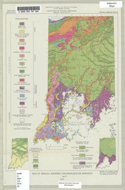
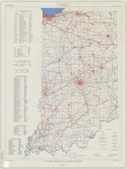
"Modified from Regional Geologic Map Series, Indiana Geological Survey." Includes insets of "Thickness of unconsolidated materials" and &...
Indiana. Geological Survey, Bleuer, N. K. (Ned Kermit), 1943-, Lineback, Jerry A. (Jerry Alvin), Hill, John R,, Gray, Henry Hamilton, 1922-, and Illinois Sta...
Publisher:
Indiana. Geological Survey
Date Created:
1979
Identifier:
VAC3073-M-01251
Genre:
Quadrangle maps, Geological maps, and Geological cross-sections
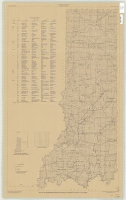
Indianapolis sheet. 1979 edition. Transverse Mercator projection. Geology compiled by H. H. Gray (Indiana) and J. A. Lineback (Illinois) from published and o...
Topical Subject: Coal mines and mining and Geographic Subject: Indiana
Creator:
Hutchison, Harold C. (Harold Christy), 1925-
Publisher:
Indiana. Geological Survey
Date Created:
1975
Identifier:
VAC3073-M-00704
Genre:
Mine maps
Geographic Location:
Coordinates: W0872723 W0862628 N0403749 N0374618
Related URL:
Catalog URL: https://iucat.iu.edu/catalog/5050615
Abstract:
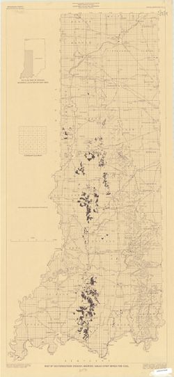
Blue line print. "Base modified from Indiana Department of Conservation, Geological Survey, Base map of portion of western Indiana, 1951." Includes...
Topical Subject: Coal mines and mining and Geographic Subject: Indiana
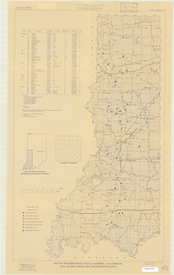
Creator:
Hutchison, Harold C. (Harold Christy), 1925-
Publisher:
Indiana. Geological Survey
Date Created:
1974
Identifier:
VAC3073-M-00711
Genre:
Thematic maps and Mine maps
Geographic Location:
Coordinates: W0880100 W0862800 N0403900 N0374500
Related URL:
Catalog URL: https://iucat.iu.edu/catalog/5046466
Abstract:
Blue line print. "Base modified from Indiana Department of Conservation, Geological Survey. Base map of portion of western Indiana, 1951." Includes...
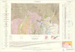
Schneider, Allan F. (Allan Frank), 1926-, Gooding, Ansel Miller, Forsyth, Jane L. (Jane Louise), 1921-, Gray, Henry Hamilton, 1922-, and Indiana. Geological ...
Publisher:
Indiana. Geological Survey
Date Created:
1972
Identifier:
VAC3073-M-01245
Genre:
Geological maps, Geological cross-sections, and Quadrangle maps
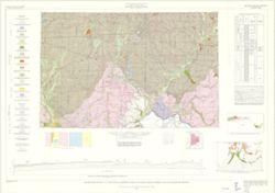
By Henry H. Gray, Jane L. Forsyth, Allan F. Schneider, and Ansel M. Gooding. Transverse Mercator projection. "Base map modified from Army Map Service, M...
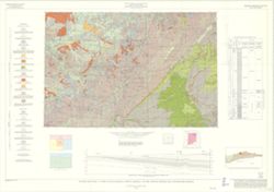
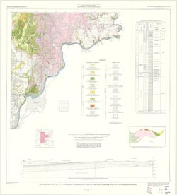
By Gerald H. Johnson and Stanley J. Keller. transverse Mercator projection. Regional geologic map , no. 8. Relief shown by profile. Includes columnar section...
By Henry H. Gray. Compiled by H. H. Gray and A. M. Burger. Drafted by J. R. Tolen. Base map modified from Army Map Service Map NJ16-6, 1964. Transverse Merca...