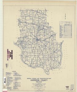
Topical Subject: Roads and Geographic Subject: Harrison County (Ind.)
Creator:
Indiana. State Highway Commission (1919-1953)
Publisher:
State Highway Commission of Indiana
Date Created:
1949
Identifier:
VAC3073-M-00181
Genre:
Road maps
Geographic Location:
Coordinates: W0862000 W0855400 N0382500 N0375700
Related URL:
Catalog URL: https://iucat.iu.edu/catalog/5732780
Abstract:
Blueline. "State roads revised to January 1, 1949." "Data obtained from State-wide Highway Planning Survey." Includes chart "Culture...
Call Number:
G4093.H4P2 1949 .I53
Caption:
Imprint: [Indianapolis?] : State Highway Commission of Indiana, 1949.
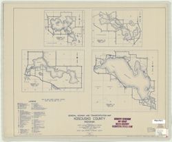
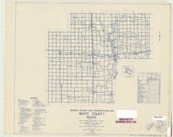
Topical Subject: Roads and Geographic Subject: Kosciusko County (Ind.)
Creator:
Indiana. State Highway Commission (1919-1953)
Publisher:
State Highway Commission of Indiana
Date Created:
1949
Identifier:
VAC3073-M-00156
Genre:
Road maps
Geographic Location:
Coordinates: W0860500 W0854000 N0412600 N0410300
Related URL:
Catalog URL: https://iucat.iu.edu/catalog/5742935
Abstract:
"State roads revised to January 1, 1949." "1937." "Data obtained from State-wide Highway Planning Survey. Includes location map and ...
Call Number:
G4093.K6 P2 1949 .I53 Suppl. Sheet
Caption:
Imprint: [Indianapolis?] : State Highway Commission of Indiana, 1949.
Physical Description:
Scale: 1:130,000 and Dimensions: 52 x 44 cm + supplementary sheet (4 maps on 1 sheet, sheet 44 x 52 cm)
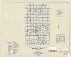
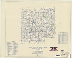
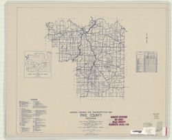
Topical Subject: Roads and Geographic Subject: Dubois County (Ind.)
Creator:
Indiana. State Highway Commission (1919-1953)
Publisher:
State Highway Commission of Indiana
Date Created:
1949
Identifier:
VAC3073-M-00142
Genre:
Road maps
Geographic Location:
Coordinates: W0870400 W0864100 N0383200 N0381200
Related URL:
Catalog URL: https://iucat.iu.edu/catalog/5704129
Abstract:
Blueline. "State roads revised to January 1, 1949." "1937." "Data obtained from Statewide Highway Planning Survey". Includes lo...
Call Number:
G4093.D8P2 1949 .I53
Caption:
Imprint: [Indianapolis?] : State Highway Commission of Indiana, 1949.
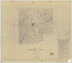
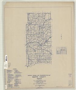
Geographic Subject: Martin County (Ind.) and Topical Subject: Roads
Creator:
Indiana. State Highway Commission (1919-1939)
Publisher:
State Highway Commission of Indiana
Date Created:
1949
Identifier:
VAC3073-M-00077
Genre:
Road maps
Geographic Location:
Coordinates: W0865500 W0864100 N0385400 N0383000
Related URL:
Catalog URL: https://iucat.iu.edu/catalog/5706861
Abstract:
Blueline. "State roads revised to January 1, 1949." "1937." "Data obtained from State-wide Highway Planning Survey." Includes ...
Call Number:
G4093.M5 P2 1949 .I53
Caption:
Imprint: [Indianapolis?] : State Highway Commission of Indiana, 1949.
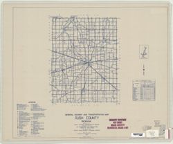
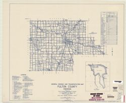
Topical Subject: Roads, Geographic Subject: Lake Manitou (Ind.), Geographic Subject: Fulton County (Ind.), and Topical Subject: Lakes
Creator:
Indiana. State Highway Commission (1919-1953)
Publisher:
State Highway Commission of Indiana
Date Created:
1949
Identifier:
VAC3073-M-00031
Genre:
Road maps
Geographic Location:
Coordinates: W0862800 W0855700 N0411000 N0405500
Related URL:
Catalog URL: https://iucat.iu.edu/catalog/5705922
Abstract:
Blueline. "State road revised to January 1, 1949." "Data obtained from Statewide Highway Planning Survey." Includes chart, "Culture ...
Call Number:
G4093.F8P2 1949 .I53
Caption:
Imprint: [Indianapolis, IN] : State Highway Commission of Indiana, 1949.