
Search Constraints
Search Results
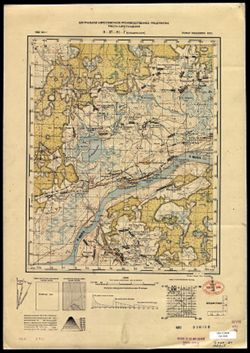
-
- Subject:
- Geographic Subject: Chernopenye, Topical Subject: Soviet Union, and Topical Subject: Maps
- Publisher:
- Центральное аэросъемочное производственное предприятие треста Аэрогеодезия
- Language:
- Russian
- Identifier:
- VAC9619-003521
- Genre:
- Topographic Maps and Military Maps
- Geographic Location:
- Coordinates: 57.5, 41, 57.667, 41.25
- Related URL:
- Catalog URL: http://iucat.iu.edu/catalog/5020131 and Download GeoTIFF: https://drive.google.com/file/d/1CbNxFdBQATCSF-pVZsCwyDuXH5qsSM5f/view?usp=sharing
- Abstract:
- Modern area represented: Chernopenye, Kostroma oblast, Russia
- Call Number:
- GM G7000 s50 .S68 sheet O-37-95-A
- City:
- Чернопенье (Chernopenye)
- Copyright Holder:
- No Copyright - United States
- Country:
- СССР (USSR)
- State/Province:
- РСФСР (RSFSR) and Ярославская область (Yaroslavl oblast)
- Physical Description:
- Scale: 1:50,000
- Persistent URL:
- http://purl.dlib.indiana.edu/iudl/images/VAC9619/VAC9619-003521
- Provenance:
- DMA Topographic Center, Army Map Service Library, OMAHA, Library of Congress Geography & Map Division
-
- Description:
- 1933
- Subject:
- Geographic Subject: Kosmynino, Topical Subject: Maps, and Topical Subject: Soviet Union
- Publisher:
- Центральное аэросъемочное производственное предприятие треста Аэрогеодезия
- Language:
- Russian
- Identifier:
- VAC9619-003520
- Genre:
- Military Maps and Topographic Maps
- Geographic Location:
- Coordinates: 57.5, 40.75, 57.667, 41
- Related URL:
- Download GeoTIFF: https://drive.google.com/file/d/1qR6BDVlq8CUzsCxPfiRsezxc0gx4jbsN/view?usp=sharing and Catalog URL: http://iucat.iu.edu/catalog/5020131
- Abstract:
- Modern area represented: Kosmynino, Kostroma oblast, Russia
- Call Number:
- GM G7000 s50 .S68 sheet O-37-94-B
- Caption:
- Не подлежит оглашению
- City:
- Косминино (Kosminino)
- Copyright Holder:
- No Copyright - United States
- Country:
- СССР (USSR)
- State/Province:
- Ивановская промышленная область (Ivanovo industrial oblast)
- Physical Description:
- Scale: 1:50,000
- Persistent URL:
- http://purl.dlib.indiana.edu/iudl/images/VAC9619/VAC9619-003520
- Provenance:
- DMA Topographic Center, Army Map Service Library, OMAHA, Library of Congress Geography & Map Division
-
- Description:
- 1933
- Subject:
- Topical Subject: Maps, Topical Subject: Soviet Union, and Geographic Subject: Gridino
- Publisher:
- Центральное аэросъемочное производственное предприятие треста Аэрогеодезия
- Language:
- Russian
- Identifier:
- VAC9619-003519
- Genre:
- Topographic Maps and Military Maps
- Geographic Location:
- Coordinates: 57.667, 41, 57.833, 41.25
- Related URL:
- Download GeoTIFF: https://drive.google.com/file/d/1uNwCIQGYN1SCfeJFPKxLNjPXiG304yJJ/view?usp=sharing and Catalog URL: http://iucat.iu.edu/catalog/5020131
- Abstract:
- Modern area represented: Gridino, Kostroma oblast, Russia
- Call Number:
- GM G7000 s50 .S68 sheet O-37-83-С
- Caption:
- Не подлежит оглашению
- City:
- Гридино (Gridino)
- Copyright Holder:
- No Copyright - United States
- Country:
- СССР (USSR)
- State/Province:
- Ивановская промышленная область (Ivanovo industrial oblast)
- Physical Description:
- Scale: 1:50,000
- Persistent URL:
- http://purl.dlib.indiana.edu/iudl/images/VAC9619/VAC9619-003519
- Provenance:
- DMA Topographic Center, Army Map Service Library, OMAHA, Library of Congress Geography & Map Division
-
- Description:
- 1938
- Subject:
- Topical Subject: Maps, Topical Subject: Soviet Union, and Geographic Subject: Klin
- Publisher:
- Главное управление геодезии и картографии при СНК СССР
- Language:
- Russian
- Date Created:
- 1941
- Identifier:
- VAC9619-003517
- Genre:
- Topographic Maps and Military Maps
- Geographic Location:
- Coordinates: 56.167, 36.5, 56.333, 36.75
- Related URL:
- Catalog URL: http://iucat.iu.edu/catalog/5020131 and Download GeoTIFF: https://drive.google.com/file/d/1ZMLM09iyeI7_y2lx4RQCcTHNIRjBbZTL/view?usp=sharing
- Abstract:
- Modern area represented: Klin, Russia
- Call Number:
- GM G7000 s50 .S68 sheet O-37-134-A
- City:
- Клин (Klin)
- Copyright Holder:
- No Copyright - United States
- Country:
- СССР (USSR)
- State/Province:
- Солнечногорский район (Solnechnogorsky district), Московская область (Moscow oblast), and Клинский район (Klinsky district)
- Physical Description:
- Scale: 1:50,000
- Persistent URL:
- http://purl.dlib.indiana.edu/iudl/images/VAC9619/VAC9619-003517
- Provenance:
- DMA Topographic Center, Army Map Service Library, Library of Congress Geography & Map Division
-
- Subject:
- Topical Subject: Soviet Union, Topical Subject: Maps, and Geographic Subject: Nekrasovskoye
- Publisher:
- Центральное аэросъемочное производственное предприятие треста Аэрогеодезия
- Language:
- Russian
- Identifier:
- VAC9619-003518
- Genre:
- Topographic Maps and Military Maps
- Geographic Location:
- Coordinates: 57.667, 40.25, 57.833, 40.5
- Related URL:
- Catalog URL: http://iucat.iu.edu/catalog/5020131 and Download GeoTIFF: https://drive.google.com/file/d/13JHb7f7c2kgIPiHm-QLjlVNKdZtic80q/view?usp=sharing
- Abstract:
- Modern area represented: Nekrasovskoye, Yaroslavl oblast, Russia
- Call Number:
- GM G7000 s50 .S68 sheet O-37-81-D
- City:
- Большие Соли (Bolshiye Soli)
- Copyright Holder:
- No Copyright - United States
- Country:
- СССР (USSR)
- State/Province:
- Ивановская область (Ivanovo oblast) and РСФСР (RSFSR)
- Physical Description:
- Scale: 1:50,000
- Persistent URL:
- http://purl.dlib.indiana.edu/iudl/images/VAC9619/VAC9619-003518
- Provenance:
- CIA Map Library, Library of Congress Geography & Map Division
-
- Description:
- 1938
- Subject:
- Topical Subject: Maps, Geographic Subject: Denkovo, and Topical Subject: Soviet Union
- Publisher:
- Главное управление геодезии и картографии при СНК СССР
- Language:
- Russian
- Date Created:
- 1941
- Identifier:
- VAC9619-003516
- Genre:
- Topographic Maps and Military Maps
- Geographic Location:
- Coordinates: 56, 36.25, 56.167, 36.5
- Related URL:
- Catalog URL: http://iucat.iu.edu/catalog/5020131 and Download GeoTIFF: https://drive.google.com/file/d/15_6DpZjY9YjpGrhF-Le1L8fdxmap_zTB/view?usp=sharing
- Abstract:
- Modern area represented: Denkovo, Russia
- Call Number:
- GM G7000 s50 .S68 sheet O-37-133-D
- City:
- Деньково (Denkovo)
- Copyright Holder:
- No Copyright - United States
- Country:
- СССР (USSR)
- State/Province:
- Волоколамский район (Volokolamsky district), Клинский район (Klinsky district), Ново-Петровский (Novopetrovsky district), and Московская область (Moscow oblast)
- Physical Description:
- Scale: 1:50,000
- Persistent URL:
- http://purl.dlib.indiana.edu/iudl/images/VAC9619/VAC9619-003516
- Provenance:
- DMA Topographic Center, Army Map Service Library, Library of Congress Geography & Map Division
-
- Subject:
- Geographic Subject: Teryayevo, Topical Subject: Soviet Union, and Topical Subject: Maps
- Publisher:
- Главное управление геодезии и картографии при СНК СССР
- Language:
- Russian
- Date Created:
- 1941
- Identifier:
- VAC9619-003515
- Genre:
- Topographic Maps and Military Maps
- Geographic Location:
- Coordinates: 56.167, 36, 56.333, 36.25
- Related URL:
- Download GeoTIFF: https://drive.google.com/file/d/10M8uz-wV7Uejy6zTPeWDdLEvJ1CG2-O-/view?usp=sharing and Catalog URL: http://iucat.iu.edu/catalog/5020131
- Abstract:
- Modern area represented: Теряево (Teryayevo), Moscow oblast, Russia
- Call Number:
- GM G7000 s50 .S68 sheet O-37-133-A
- City:
- Теряева Слобода (Teryayeva Sloboda)
- Copyright Holder:
- No Copyright - United States
- Country:
- СССР (USSR)
- State/Province:
- Волоколамский район (Volokolamsky district), Клинский район (Klinsky district), Московская область (Moscow oblast), and Лотошинский район (Lotoshinsky district)
- Physical Description:
- Scale: 1:50,000
- Persistent URL:
- http://purl.dlib.indiana.edu/iudl/images/VAC9619/VAC9619-003515
- Provenance:
- DMA Topographic Center, Army Map Service Library, Library of Congress Geography & Map Division
-
- Description:
- 1938
- Subject:
- Topical Subject: Maps, Topical Subject: Soviet Union, and Geographic Subject: Sloboda
- Publisher:
- Главное управление геодезии и картографии при СНК СССР
- Language:
- Russian
- Date Created:
- 1941
- Identifier:
- VAC9619-003514
- Genre:
- Topographic Maps and Military Maps
- Geographic Location:
- Coordinates: 56.333, 36.75, 56.5, 37
- Related URL:
- Download GeoTIFF: https://drive.google.com/file/d/1FIM5aUANKvW41Va_K16TJ3TTeA1rgXmo/view?usp=sharing and Catalog URL: http://iucat.iu.edu/catalog/5020131
- Abstract:
- Modern area represented: Sloboda, Russia
- Call Number:
- GM G7000 s50 .S68 sheet O-37-122-D
- City:
- Слобода (Sloboda)
- Copyright Holder:
- No Copyright - United States
- Country:
- СССР (USSR)
- State/Province:
- Солнечногорский район (Solnechnogorsky district), Клинский район (Klinsky district), and Московская область (Moscow oblast)
- Physical Description:
- Scale: 1:50,000
- Persistent URL:
- http://purl.dlib.indiana.edu/iudl/images/VAC9619/VAC9619-003514
- Provenance:
- DMA Topographic Center, Army Map Service Library, OMAHA, Library of Congress Geography & Map Division
-
- Description:
- 1938
- Subject:
- Topical Subject: Maps, Geographic Subject: Lotoshino, and Topical Subject: Soviet Union
- Publisher:
- Главное управление геодезии и картографии при СНК СССР
- Language:
- Russian
- Identifier:
- VAC9619-003513
- Genre:
- Military Maps and Topographic Maps
- Geographic Location:
- Coordinates: 56.16667, 35.5, 56.3333, 35.75
- Related URL:
- Catalog URL: http://iucat.iu.edu/catalog/5020131 and Download GeoTIFF: https://drive.google.com/file/d/1i9z2n6LOhMgptbpD9qBYj2kH_3jl_3Ec/view?usp=sharing
- Abstract:
- Modern area represented: Лотошино (Lotoshino), Moscow oblast, Russia
- Call Number:
- GM G7000 s50 .S68 sheet O-36-144-A
- City:
- Лотошино (Lotoshino)
- Copyright Holder:
- No Copyright - United States
- Country:
- СССР (USSR)
- State/Province:
- Московская область (Moscow oblast), Старицкий район (Staritsky district), Волоколамский район (Volokolamsky district), Шаховской район (Shakhovsky district),...
- Physical Description:
- Scale: 1:50,000
- Persistent URL:
- http://purl.dlib.indiana.edu/iudl/images/VAC9619/VAC9619-003513
- Provenance:
- DMA Topographic Center, Army Map Service Library, Library of Congress Geography & Map Division
-

- Description:
- 1939
- Subject:
- Geographic Subject: Gorodkovo, Topical Subject: Soviet Union, and Topical Subject: Maps
- Publisher:
- Главное управление геодезии и картографии при СНК СССР
- Language:
- Russian
- Date Created:
- 1941
- Identifier:
- VAC9619-003512
- Genre:
- Topographic Maps and Military Maps
- Geographic Location:
- Coordinates: 56.0, 35.25, 56.16667, 35.5
- Related URL:
- Download GeoTIFF: https://drive.google.com/file/d/1Ac04NnRe-NzKr_Rd_4abwOlEUVYMcFWL/view?usp=sharing and Catalog URL: http://iucat.iu.edu/catalog/5020131
- Abstract:
- Modern area represented: Городково (Gorodkovo), Moscow oblast, Russia
- Call Number:
- GM G7000 s50 .S68 sheet O-36-143-D
- City:
- Городково (Gorodkovo)
- Copyright Holder:
- No Copyright - United States
- Country:
- СССР (USSR)
- State/Province:
- Шаховской район (Shakhovsky district), Калининская область (Kalinin oblast), Московская область (Moscow oblast), and Погорельский район (Pogorelsky district)
- Physical Description:
- Scale: 1:50,000
- Persistent URL:
- http://purl.dlib.indiana.edu/iudl/images/VAC9619/VAC9619-003512
- Provenance:
- DMA Topographic Center, Army Map Service Library, OMAHA, Library of Congress Geography & Map Division
