
Search Constraints
You searched for:
Provenance
M. I. Map Library
Remove constraint Provenance: M. I. Map Library
« Previous |
1 - 20 of 179
|
Next »
Search Results
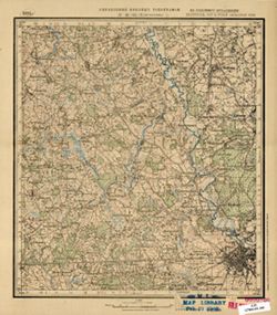
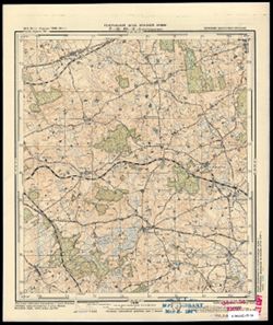
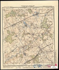
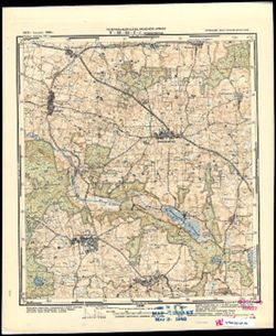
-
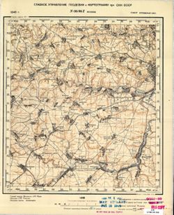
- Description:
- 1940
- Subject:
- Topical Subject: Soviet Union, Geographic Subject: Bolkhov, and Topical Subject: Maps
- Publisher:
- Главное Управление Геодезии и Картографии при СНК СССР
- Language:
- Russian
- Date Created:
- 1941
- Identifier:
- VAC9619-001478
- Genre:
- Military Maps and Topographic Maps
- Geographic Location:
- Coordinates: 53.3333, 35.75, 53.5, 36
- Related URL:
- Catalog URL: http://iucat.iu.edu/catalog/5020131 and Download GeoTIFF: https://drive.google.com/open?id=14GGU-2tZQhcnZj2XMD6SOTLnhCnhaWpk
- Abstract:
- Modern area represented: Bolkhov, Oryol oblast, Russia
- Call Number:
- G7000 s50 .S68 sheet N-36-96-D
- City:
- Болхов (Bolkhov)
- Copyright Holder:
- No Copyright - United States
- Country:
- СССР (USSR)
- State/Province:
- РСФСР (RSFSR) and Орловская область (Oryol oblast)
- Physical Description:
- Scale: 1:50,000
- Persistent URL:
- http://purl.dlib.indiana.edu/iudl/images/VAC9619/VAC9619-001478
- Provenance:
- M. I. Map Library
-
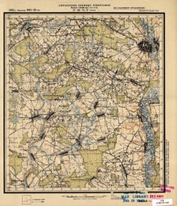
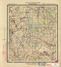
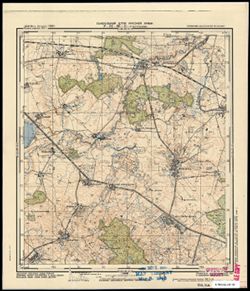
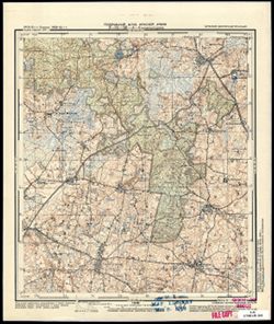
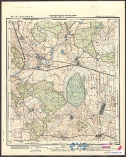
- Description:
- 1923
- Subject:
- Topical Subject: Maps, Geographic Subject: Chavusi, and Topical Subject: Soviet Union
- Publisher:
- Управление военных топографов
- Language:
- Russian
- Date Created:
- 1926
- Identifier:
- VAC9619-001402
- Genre:
- Topographic Maps and Military Maps
- Geographic Location:
- Coordinates: 53.667, 30.75, 53.833, 31
- Related URL:
- Catalog URL: http://iucat.iu.edu/catalog/5020131 and Download GeoTIFF: https://drive.google.com/open?id=19RCJP_F7aEs1hzwZ1krEnOEdA-MdnvHR
- Abstract:
- Modern area represented: Chavusi, Mogilev oblast, Belarus
- Call Number:
- GM G7000 S50 .S68 N-36-74-Г
- Caption:
- Не подлежит оглашению
- City:
- Чаусы (Chavusi)
- Copyright Holder:
- No Copyright - United States
- Country:
- СССР (USSR)
- State/Province:
- Белорусская ССР (Byelorussian Soviet Socialist Republic)
- Physical Description:
- Scale: 1:50,000
- Persistent URL:
- http://purl.dlib.indiana.edu/iudl/images/VAC9619/VAC9619-001402
- Provenance:
- M. I. Map Library
-
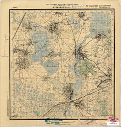
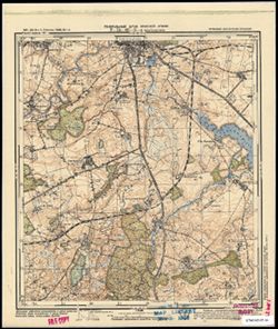
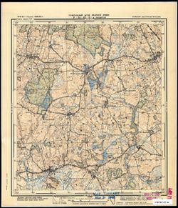
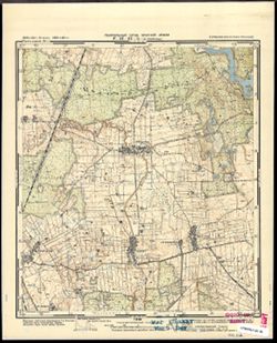
- Description:
- 1929
- Subject:
- Geographic Subject: Goleni, Topical Subject: Soviet Union, and Topical Subject: Maps
- Publisher:
- Военно-топографическое управление
- Language:
- Russian
- Identifier:
- VAC9619-001401
- Genre:
- Military Maps and Topographic Maps
- Geographic Location:
- Coordinates: 53.667, 30.5, 53.833, 30.75
- Related URL:
- Catalog URL: http://iucat.iu.edu/catalog/5020131 and Download GeoTIFF: https://drive.google.com/open?id=1BV4Dwp8i4A8x77fOV4CI3WD0Vl_svmlS
- Abstract:
- Modern area represented: Goleni, Mogilev oblast, Belarus
- Call Number:
- GM G7000 S50 .S68 N-36-74-B
- Caption:
- Секретно
- City:
- Голени (Goleni)
- Copyright Holder:
- No Copyright - United States
- Country:
- СССР (USSR)
- State/Province:
- Белорусская ССР (Byelorussian Soviet Socialist Republic) and Могилевский округ (Mogilev district)
- Physical Description:
- Scale: 1:50,000
- Persistent URL:
- http://purl.dlib.indiana.edu/iudl/images/VAC9619/VAC9619-001401
- Provenance:
- M. I. Map Library
-
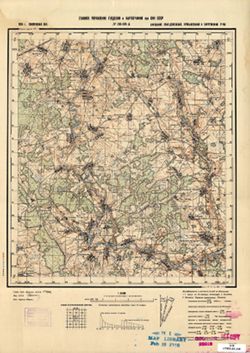
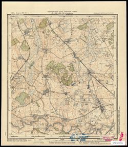
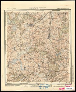
- Description:
- 1939
- Subject:
- Geographic Subject: Obolovka, Topical Subject: Soviet Union, and Topical Subject: Maps
- Publisher:
- Главное Управление Геодезии и Картографии при СНК СССР
- Language:
- Russian
- Date Created:
- 1941
- Identifier:
- VAC9619-001390
- Genre:
- Military Maps and Topographic Maps
- Geographic Location:
- Coordinates: 54.167, 34, 54.333, 34.25
- Related URL:
- Catalog URL: http://iucat.iu.edu/catalog/5020131 and Download GeoTIFF: https://drive.google.com/open?id=1VsZbplGMsLLd__zWU7u-PLSDg0zyyJ9Q
- Abstract:
- Modern area represented: Obolovka, Kaluga oblast, Russia
- Call Number:
- GM G7000 S50 .S68 N-36-69-A
- Copyright Holder:
- No Copyright - United States
- Country:
- СССР (USSR)
- State/Province:
- Смоленская область (Smolensk oblast) and РСФСР (RSFSR)
- Physical Description:
- Scale: 1:50,000
- Persistent URL:
- http://purl.dlib.indiana.edu/iudl/images/VAC9619/VAC9619-001390
- Provenance:
- M. I. Map Library
-
- Description:
- 1924
- Subject:
- Geographic Subject: Mstsislaw, Topical Subject: Soviet Union, and Topical Subject: Maps
- Publisher:
- Управление военных топографов
- Language:
- Russian
- Identifier:
- VAC9619-001375
- Genre:
- Military Maps and Topographic Maps
- Geographic Location:
- Coordinates: 54, 31.5, 54.1667, 31.75
- Related URL:
- Download GeoTIFF: https://drive.google.com/file/d/1L1ah-Q0gps1bW43RnmJmxuVOEQY7S9NL/view?usp=sharing and Catalog URL: http://iucat.iu.edu/catalog/5020131
- Abstract:
- Modern area represented: Mstsislaw, Mogilev oblast, Belarus
- Call Number:
- GM G7000 S50 .S68 N-36-64-B
- Caption:
- Не подлежит оглашению
- City:
- Мстиславль (Mstsislaw)
- Copyright Holder:
- No Copyright - United States
- Country:
- СССР (USSR)
- State/Province:
- РСФСР (RSFSR), Белорусская ССР (Byelorussian Soviet Socialist Republic), and Западная область (Western oblast)
- Physical Description:
- Scale: 1:50,000
- Persistent URL:
- http://purl.dlib.indiana.edu/iudl/images/VAC9619/VAC9619-001375
- Provenance:
- M. I. Map Library
-

- Description:
- 1924
- Subject:
- Geographic Subject: Tatarsk, Topical Subject: Maps, and Topical Subject: Soviet Union
- Publisher:
- Управление военных топографов
- Language:
- Russian
- Identifier:
- VAC9619-001373
- Genre:
- Topographic Maps and Military Maps
- Geographic Location:
- Coordinates: 54.167, 31.5, 54.333, 31.75
- Related URL:
- Catalog URL: http://iucat.iu.edu/catalog/5020131 and Download GeoTIFF: https://drive.google.com/open?id=1i1g0zyiz8i8nDK20MIZq8VFAYlEXqWpb
- Abstract:
- Modern area represented: Tatarsk, Smolensk oblast, Russia
- Call Number:
- GM G7000 S50 .S68 N-36-64-A
- Caption:
- Не подлежит оглашению
- City:
- Татарск (Tatarsk)
- Copyright Holder:
- No Copyright - United States
- Country:
- СССР (USSR)
- State/Province:
- Западная область (Western oblast), РСФСР (RSFSR), and Белорусская ССР (Byelorussian Soviet Socialist Republic)
- Physical Description:
- Scale: 1:50,000
- Persistent URL:
- http://purl.dlib.indiana.edu/iudl/images/VAC9619/VAC9619-001373
- Provenance:
- M. I. Map Library
-
- Description:
- 1929
- Subject:
- Topical Subject: Maps, Geographic Subject: Chernyewka, and Topical Subject: Soviet Union
- Publisher:
- Военно-топографическое управление
- Language:
- Russian
- Identifier:
- VAC9619-001367
- Genre:
- Military Maps and Topographic Maps
- Geographic Location:
- Coordinates: 54, 30.75, 54.167, 31
- Related URL:
- Download GeoTIFF: https://drive.google.com/open?id=1ks1AbVqIAR5BcadeBjkMuTy0LpsWS-jY and Catalog URL: http://iucat.iu.edu/catalog/5020131
- Abstract:
- Modern area represented: Chernyewka, Mogilev oblast, Belarus
- Call Number:
- GM G7000 S50 .S68 N-36-62-Г
- Caption:
- Секретно
- City:
- Черневка (Chernyewka)
- Copyright Holder:
- No Copyright - United States
- Country:
- СССР (USSR)
- State/Province:
- Белорусская ССР (Byelorussian Soviet Socialist Republic) and Могилевский округ (Mogilev district)
- Physical Description:
- Scale: 1:50,000
- Persistent URL:
- http://purl.dlib.indiana.edu/iudl/images/VAC9619/VAC9619-001367
- Provenance:
- M. I. Map Library
-
- Description:
- 1928
- Subject:
- Topical Subject: Maps, Topical Subject: Soviet Union, and Geographic Subject: Мостище (Mostyshche)
- Publisher:
- Управление военных топографов
- Language:
- Russian
- Identifier:
- VAC9619-000944
- Genre:
- Military Maps and Topographic Maps
- Geographic Location:
- Coordinates: 50.6667, 31, 50.8333, 31.25
- Related URL:
- Catalog URL: http://iucat.iu.edu/catalog/5020131 and Download GeoTIFF: https://drive.google.com/open?id=1l6N3jMmap6b0-GJ9z4qCApZcFQhcMD8y
- Abstract:
- Modern area represented: Мостище (Mostyshche), Chernihiv oblast, Ukraine
- Call Number:
- G7000 s50 .S68 sheet M-36-39-C
- Caption:
- Не подлежит оглашению
- City:
- Мостище (Mostishche)
- Copyright Holder:
- No Copyright - United States
- Country:
- СССР (USSR)
- State/Province:
- Украинская ССР (Ukrainian Soviet Socialist Republic)
- Physical Description:
- Scale: 1:50,000
- Persistent URL:
- http://purl.dlib.indiana.edu/iudl/images/VAC9619/VAC9619-000944
- Provenance:
- M. I. Map Library
-
- Description:
- 1929
- Subject:
- Geographic Subject: Ковпита (Kovpyta), Topical Subject: Maps, and Topical Subject: Soviet Union
- Publisher:
- Управление военных топографов
- Language:
- Russian
- Date Created:
- 1934
- Identifier:
- VAC9619-000922
- Genre:
- Topographic Maps and Military Maps
- Geographic Location:
- Coordinates: 51.3333, 30.75, 51.5, 31
- Related URL:
- Download GeoTIFF: https://drive.google.com/open?id=1wwFBx8Ytl_OyaIeA8BqneJwwGcqknvXo and Catalog URL: http://iucat.iu.edu/catalog/5020131
- Abstract:
- Modern area represented: Ковпита (Kovpyta), Chernihiv Oblast, Ukraine
- Call Number:
- G7000 s50 .S68 sheet M-36-14-D
- Caption:
- Не подлежит оглашению
- City:
- Колпыта (Kolpyta)
- Copyright Holder:
- No Copyright - United States
- Country:
- СССР (USSR)
- State/Province:
- Украинская ССР (Ukrainian Soviet Socialist Republic)
- Physical Description:
- Scale: 1:50,000
- Persistent URL:
- http://purl.dlib.indiana.edu/iudl/images/VAC9619/VAC9619-000922
- Provenance:
- M. I. Map Library
-
- Subject:
- Topical Subject: Soviet Union, Topical Subject: Maps, and Geographic Subject: Rogóż
- Publisher:
- Генеральный штаб Красной Армии
- Language:
- Russian
- Date Created:
- 1941
- Identifier:
- VAC9619-003811
- Genre:
- Military Maps and Topographic Maps
- Geographic Location:
- Coordinates: 54.083, 20.625, 54.1667, 20.75
- Related URL:
- Catalog URL: https://iucat.iu.edu/catalog/14701157 and Download GeoTIFF: https://drive.google.com/file/d/1giUT-j1OySHQI7HrtDK2bCgEnjETFz6O/view?usp=sharing
- Abstract:
- Modern area represented: Rogóż, Poland
- Call Number:
- G7063.K2 s25 .S6 sheet N-34-66-C-b
- City:
- Роггенхаузен (Roggenhausen)
- Copyright Holder:
- No Copyright - United States
- Country:
- Германия (Восточная Пруссия) (Germany (East Prussia))
- Physical Description:
- Scale: 1:25,000
- Persistent URL:
- http://purl.dlib.indiana.edu/iudl/images/VAC9619/VAC9619-003811
- Provenance:
- M. I. Map Library
-
- Subject:
- Topical Subject: Soviet Union, Geographic Subject: Wiatrowiec, and Topical Subject: Maps
- Publisher:
- Генеральный штаб Красной Армии
- Language:
- Russian
- Date Created:
- 1941
- Identifier:
- VAC9619-003809
- Genre:
- Topographic Maps and Military Maps
- Geographic Location:
- Coordinates: 54.167, 20.875, 54.25, 21
- Related URL:
- Download GeoTIFF: https://drive.google.com/file/d/1vOh3ptGYLgaG2TVRWOZ5aB1k8PU4GEkW/view?usp=sharing and Catalog URL: https://iucat.iu.edu/catalog/14701157
- Abstract:
- Modern area represented: Wiatrowiec, Poland
- Call Number:
- G7063.K2 s25 .S6 sheet N-34-66-B-d
- City:
- Вотеркайм (Wöterkeim)
- Copyright Holder:
- No Copyright - United States
- Country:
- Германия (Восточная Пруссия) (Germany (East Prussia))
- Physical Description:
- Scale: 1:25,000
- Persistent URL:
- http://purl.dlib.indiana.edu/iudl/images/VAC9619/VAC9619-003809
- Provenance:
- M. I. Map Library
-
- Subject:
- Geographic Subject: Bartoszyce, Topical Subject: Soviet Union, and Topical Subject: Maps
- Publisher:
- Генеральный штаб Красной Армии
- Language:
- Russian
- Date Created:
- 1941
- Identifier:
- VAC9619-003808
- Genre:
- Topographic Maps and Military Maps
- Geographic Location:
- Coordinates: 54.1667, 20.75, 54.25, 20.875
- Related URL:
- Download GeoTIFF: https://drive.google.com/file/d/1HARliuMFQGrNYsBG8UYObEUh49nofFAd/view?usp=sharing and Catalog URL: https://iucat.iu.edu/catalog/14701157
- Abstract:
- Modern area represented: Bartoszyce, Poland (South side of the city)
- Call Number:
- G7063.K2 s25 .S6 sheet N-34-66-B-c
- City:
- Бартенштайн (Bartenstein)
- Copyright Holder:
- No Copyright - United States
- Country:
- Германия (Восточная Пруссия) (Germany (East Prussia))
- Physical Description:
- Scale: 1:25,000
- Persistent URL:
- http://purl.dlib.indiana.edu/iudl/images/VAC9619/VAC9619-003808
- Provenance:
- M. I. Map Library
-
- Subject:
- Topical Subject: Soviet Union, Topical Subject: Maps, and Geographic Subject: Judyty
- Publisher:
- Генеральный штаб Красной Армии
- Language:
- Russian
- Date Created:
- 1941
- Identifier:
- VAC9619-003807
- Genre:
- Military Maps and Topographic Maps
- Geographic Location:
- Coordinates: 54.25, 20.875, 54.333, 21
- Related URL:
- Download GeoTIFF: https://drive.google.com/file/d/1XHWlJDGtBe2K9Gnt_ge1gwDKiWKZCgIK/view?usp=sharing and Catalog URL: https://iucat.iu.edu/catalog/14701157
- Abstract:
- Modern area represented: Judyty, Poland
- Call Number:
- G7063.K2 s25 .S6 sheet N-34-66-B-b
- City:
- Юдиттен (Juditten)
- Copyright Holder:
- No Copyright - United States
- Country:
- Германия (Восточная Пруссия) (Germany (East Prussia))
- Physical Description:
- Scale: 1:25,000
- Persistent URL:
- http://purl.dlib.indiana.edu/iudl/images/VAC9619/VAC9619-003807
- Provenance:
- M. I. Map Library
-
- Subject:
- Topical Subject: Soviet Union, Geographic Subject: Rodnowo, and Topical Subject: Maps
- Publisher:
- Генеральный штаб Красной Армии
- Language:
- Russian
- Date Created:
- 1941
- Identifier:
- VAC9619-003805
- Genre:
- Topographic Maps and Military Maps
- Geographic Location:
- Coordinates: 54.167, 20.625, 54.25, 20.75
- Related URL:
- Catalog URL: https://iucat.iu.edu/catalog/14701157 and Download GeoTIFF: https://drive.google.com/file/d/16Hi8om-jODF3nfEOkWkWi5cVgvkVQ6WH/view?usp=sharing
- Abstract:
- Modern area represented: Rodnowo, Poland
- Call Number:
- G7063.K2 s25 .S6 sheet N-34-66-A-d
- City:
- Редденау (Reddenau)
- Copyright Holder:
- No Copyright - United States
- Country:
- Германия (Восточная Пруссия) (Germany (East Prussia))
- Physical Description:
- Scale: 1:25,000
- Persistent URL:
- http://purl.dlib.indiana.edu/iudl/images/VAC9619/VAC9619-003805
- Provenance:
- M. I. Map Library
-
- Subject:
- Topical Subject: Soviet Union, Geographic Subject: Wojciechy, and Topical Subject: Maps
- Publisher:
- Генеральный штаб Красной Армии
- Language:
- Russian
- Date Created:
- 1941
- Identifier:
- VAC9619-003804
- Genre:
- Topographic Maps and Military Maps
- Geographic Location:
- Coordinates: 54.25, 20.625, 54.333, 20.75
- Related URL:
- Download GeoTIFF: https://drive.google.com/file/d/11bGNN0cqZMWe8n97Ikl2o5o10LId_8HK/view?usp=sharing and Catalog URL: https://iucat.iu.edu/catalog/14701157
- Abstract:
- Modern area represented: Wojciechy, Poland
- Call Number:
- G7063.K2 s25 .S6 sheet N-34-66-A-b
- City:
- Альбрехтсдорф (Albrechtsdorf)
- Copyright Holder:
- No Copyright - United States
- Country:
- Германия (Восточная Пруссия) (Germany (East Prussia))
- Physical Description:
- Scale: 1:25,000
- Persistent URL:
- http://purl.dlib.indiana.edu/iudl/images/VAC9619/VAC9619-003804
- Provenance:
- M. I. Map Library
-
- Subject:
- Topical Subject: Maps, Geographic Subject: Kandyty, and Topical Subject: Soviet Union
- Publisher:
- Генеральный штаб Красной Армии
- Language:
- Russian
- Date Created:
- 1941
- Identifier:
- VAC9619-003798
- Genre:
- Topographic Maps and Military Maps
- Geographic Location:
- Coordinates: 54.25, 20.25, 54.33333, 20.375
- Related URL:
- Catalog URL: https://iucat.iu.edu/catalog/14701157 and Download GeoTIFF: https://drive.google.com/file/d/1S1W6QXdcqP7_Eu54P4qBVINF6B8bCYEK/view?usp=sharing
- Abstract:
- Modern area represented: Kandyty, Poland
- Call Number:
- G7063.K2 s25 .S6 sheet N-34-65-B-а
- City:
- Кандиттен (Kanditten)
- Copyright Holder:
- No Copyright - United States
- Country:
- Германия (Восточная Пруссия) (Germany (East Prussia))
- Physical Description:
- Scale: 1:25,000
- Persistent URL:
- http://purl.dlib.indiana.edu/iudl/images/VAC9619/VAC9619-003798
- Provenance:
- M. I. Map Library
-
- Subject:
- Topical Subject: Soviet Union, Geographic Subject: Janikowo, and Topical Subject: Maps
- Publisher:
- Генеральный штаб Красной Армии
- Language:
- Russian
- Date Created:
- 1941
- Identifier:
- VAC9619-003799
- Genre:
- Military Maps and Topographic Maps
- Geographic Location:
- Coordinates: 54.166667, 20.375, 54.25, 20.5
- Related URL:
- Download GeoTIFF: https://drive.google.com/file/d/1Xsw9w_3pOgyqqB2i9TaLhREcbeMMsS7h/view?usp=sharing and Catalog URL: https://iucat.iu.edu/catalog/14701157
- Abstract:
- Modern area represented: Janikowo, Poland
- Call Number:
- G7063.K2 s25 .S6 sheet N-34-65-B-d
- City:
- Хансхаген (Hanshagen)
- Copyright Holder:
- No Copyright - United States
- Country:
- Германия (Восточная Пруссия) (Germany (East Prussia))
- Physical Description:
- Scale: 1:25,000
- Persistent URL:
- http://purl.dlib.indiana.edu/iudl/images/VAC9619/VAC9619-003799
- Provenance:
- M. I. Map Library
-
- Subject:
- Topical Subject: Soviet Union, Topical Subject: Maps, and Geographic Subject: Ząbrowiec
- Publisher:
- Генеральный штаб Красной Армии
- Language:
- Russian
- Date Created:
- 1941
- Identifier:
- VAC9619-003797
- Genre:
- Topographic Maps and Military Maps
- Geographic Location:
- Coordinates: 54.0, 19.875, 54.083333, 20.0
- Related URL:
- Download GeoTIFF: https://drive.google.com/file/d/1nub9sHE446K5kjM5zIXU4yACyWY9K6dq/view?usp=sharing and Catalog URL: https://iucat.iu.edu/catalog/14701157
- Abstract:
- Modern area represented: Ząbrowiec, Poland
- Call Number:
- G7063.K2 s25 .S6 sheet N-34-64-D-d
- City:
- Зоммерфельд (Sommerfeld)
- Copyright Holder:
- No Copyright - United States
- Country:
- Германия (Восточная Пруссия) (Germany (East Prussia))
- Physical Description:
- Scale: 1:25,000
- Persistent URL:
- http://purl.dlib.indiana.edu/iudl/images/VAC9619/VAC9619-003797
- Provenance:
- M. I. Map Library
-
- Subject:
- Topical Subject: Maps, Topical Subject: Soviet Union, and Geographic Subject: Słobity
- Publisher:
- Генеральный штаб Красной Армии
- Language:
- Russian
- Date Created:
- 1941
- Identifier:
- VAC9619-003795
- Genre:
- Military Maps and Topographic Maps
- Geographic Location:
- Coordinates: 54.083333, 19.75, 54.166667, 19.875
- Related URL:
- Download GeoTIFF: https://drive.google.com/file/d/1wC6BkTBVCh1PKvinAe59WAy9VgPbh8fk/view?usp=sharing and Catalog URL: https://iucat.iu.edu/catalog/14701157
- Abstract:
- Modern area represented: Słobity, Poland
- Call Number:
- G7063.K2 s25 .S6 sheet N-34-64-D-а
- City:
- Шлобиттен (Schlobitten)
- Copyright Holder:
- No Copyright - United States
- Country:
- Германия (Восточная Пруссия) (Germany (East Prussia))
- Physical Description:
- Scale: 1:25,000
- Persistent URL:
- http://purl.dlib.indiana.edu/iudl/images/VAC9619/VAC9619-003795
- Provenance:
- M. I. Map Library
-
- Subject:
- Topical Subject: Soviet Union, Topical Subject: Maps, and Geographic Subject: Stare Siedlisko
- Publisher:
- Генеральный штаб Красной Армии
- Language:
- Russian
- Date Created:
- 1941
- Identifier:
- VAC9619-003792
- Genre:
- Topographic Maps and Military Maps
- Geographic Location:
- Coordinates: 54.166667, 19.75, 54.25, 19.875
- Related URL:
- Download GeoTIFF: https://drive.google.com/file/d/1-NGFOGxtQ39d_ZGjH79l6Guy-5yjoHYB/view?usp=sharing and Catalog URL: https://iucat.iu.edu/catalog/14701157
- Abstract:
- Modern area represented: Stare Siedlisko, Poland
- Call Number:
- G7063.K2 s25 .S6 sheet N-34-64-B-c
- City:
- Эберсбах (Ebersbach)
- Copyright Holder:
- No Copyright - United States
- Country:
- Германия (Восточная Пруссия) (Germany (East Prussia))
- Physical Description:
- Scale: 1:25,000
- Persistent URL:
- http://purl.dlib.indiana.edu/iudl/images/VAC9619/VAC9619-003792
- Provenance:
- M. I. Map Library
