
Search Constraints
You searched for:
Publisher
Главное управление геодезии и картографии при СНК СССР
Remove constraint Publisher: Главное управление геодезии и картографии при СНК СССР
Search Results
-
- Description:
- 1939
- Subject:
- Topical Subject: Soviet Union, Geographic Subject: Naziya, and Topical Subject: Maps
- Publisher:
- Главное управление геодезии и картографии при СНК СССР
- Language:
- Russian
- Identifier:
- VAC9619-002120
- Genre:
- Military Maps and Topographic Maps
- Geographic Location:
- Coordinates: 59.6667, 31.5, 60, 32
- Related URL:
- Download GeoTIFF: https://drive.google.com/open?id=1B8Uh942KKV6UWAUgAW9DT4tCw9w4QylH and Catalog URL: https://iucat.iu.edu/catalog/5020129
- Abstract:
- Modern area represented: Naziya, Leningrad oblast, Russia
- Call Number:
- G7000 s100 .S7 sheet O-36-4
- Caption:
- Для служебного пользования
- City:
- Назия (Naziya)
- Copyright Holder:
- No Copyright - United States
- Country:
- СССР (USSR)
- State/Province:
- Ленинградская область (Leningrad oblast)
- Physical Description:
- Scale: 1:100,000
- Persistent URL:
- http://purl.dlib.indiana.edu/iudl/images/VAC9619/VAC9619-002120
- Provenance:
- DMA Topographic Center, Army Map Service Library, OMAHA
-
- Description:
- 1937
- Subject:
- Topical Subject: Maps, Topical Subject: Soviet Union, and Geographic Subject: Belev
- Publisher:
- Главное управление геодезии и картографии при СНК СССР
- Language:
- Russian
- Identifier:
- VAC9619-003139
- Genre:
- Topographic Maps and Military Maps
- Geographic Location:
- Coordinates: 53.667, 36, 54, 36.5
- Related URL:
- Catalog URL: https://iucat.iu.edu/catalog/5020129 and Download GeoTIFF: https://drive.google.com/file/d/1dC5B95Zg7rHaLuFhajznZpJAhrUivze3/view?usp=sharing
- Abstract:
- Modern area represented: Belev, Russia
- Call Number:
- G7000 s100 .S7 sheet N-37-73
- City:
- Белев (Belev)
- Copyright Holder:
- No Copyright - United States
- Country:
- СССР (USSR)
- State/Province:
- Орловская область (Oryol oblast), Тульская область (Tula oblast), Смоленская область (Smolensk oblast), and РСФСР (RSFSR)
- Physical Description:
- Scale: 1:100,000
- Persistent URL:
- http://purl.dlib.indiana.edu/iudl/images/VAC9619/VAC9619-003139
- Provenance:
- DMA Topographic Center, Army Map Service Library, OMAHA, Library of Congress Geography & Map Division, Auswärtiges Amt. Geographischer Dienst
-
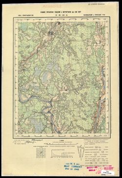
- Description:
- 1939
- Subject:
- Geographic Subject: Rudakovo, Topical Subject: Maps, and Topical Subject: Soviet Union
- Publisher:
- Главное управление геодезии и картографии при СНК СССР
- Language:
- Russian
- Identifier:
- VAC9619-002835
- Genre:
- Military Maps and Topographic Maps
- Geographic Location:
- Coordinates: 57.167, 32.25.57.333, 32.5
- Related URL:
- Catalog URL: http://iucat.iu.edu/catalog/5020131 and Download GeoTIFF: https://drive.google.com/file/d/1NPUTz0j3RjGsUXMQwZdDDhA-909EG57s/view?usp=sharing
- Abstract:
- Modern area represented: Рудаково (Rudakovo), Марёвский район (Marevskiy Rayon), Новгородская область (Novgorodskaya oblast), Russia
- Call Number:
- GM G7000 s50 .S68 sheet O-36-101-B
- City:
- Рудаково (Rudakovo)
- Copyright Holder:
- No Copyright - United States
- Country:
- СССР (USSR)
- State/Province:
- Ленинградская область (Leningrad oblast), Осташковский район (Ostashkovsky district), Калининская область (Kalinin oblast), Молвотицкий район (Molvotitsky di...
- Physical Description:
- Scale: 1:50,000
- Persistent URL:
- http://purl.dlib.indiana.edu/iudl/images/VAC9619/VAC9619-002835
- Provenance:
- DMA Topographic Center, Army Map Service Library, OMAHA, Library of Congress Geography & Map Division
-
- Description:
- 1938
- Subject:
- Geographic Subject: Torzhok, Topical Subject: Soviet Union, and Topical Subject: Maps
- Publisher:
- Главное управление геодезии и картографии при СНК СССР
- Language:
- Russian
- Identifier:
- VAC9619-002849
- Genre:
- Military Maps and Topographic Maps
- Geographic Location:
- Coordinates: 57, 34.75, 57.167, 35
- Related URL:
- Download GeoTIFF: https://drive.google.com/file/d/1XNzC-ei7_34RCP8JJeFeo-6bPwfGAXCP/view?usp=sharing and Catalog URL: http://iucat.iu.edu/catalog/5020131
- Abstract:
- Modern area represented: Торжок (Torzhok), Тверская область (Tverskaya oblast), Russia
- Call Number:
- GM G7000 s50 .S68 sheet O-36-106-D
- Caption:
- Для служебного пользования
- City:
- Торжок (Torzhok)
- Copyright Holder:
- No Copyright - United States
- Country:
- СССР (USSR)
- State/Province:
- Калининская область (Kalinin oblast) and Новоторжский район (Novotorzhsky district)
- Physical Description:
- Scale: 1:50,000
- Persistent URL:
- http://purl.dlib.indiana.edu/iudl/images/VAC9619/VAC9619-002849
- Provenance:
- DMA Topographic Center, Army Map Service Library, OMAHA, Library of Congress Geography & Map Division
-
- Description:
- 1939
- Subject:
- Geographic Subject: Khotovo, Topical Subject: Soviet Union, and Topical Subject: Maps
- Publisher:
- Главное управление геодезии и картографии при СНК СССР
- Language:
- Russian
- Identifier:
- VAC9619-003003
- Genre:
- Topographic Maps and Military Maps
- Geographic Location:
- Coordinates: 59.667, 32, 59.833, 32.25
- Related URL:
- Catalog URL: http://iucat.iu.edu/catalog/5020131 and Download GeoTIFF: https://drive.google.com/file/d/1aAxrCsTissYEBPfIjFR-WJZPjdYV7qTb/view?usp=sharing
- Abstract:
- Modern area represented: Khotovo, Leningrad oblast, Russia
- Call Number:
- GM G7000 s50 .S68 sheet O-36-5-C
- Caption:
- Секретно,Captured map
- City:
- Хотово (Khotovo)
- Copyright Holder:
- No Copyright - United States
- Country:
- СССР (USSR)
- State/Province:
- Ленинградская область (Leningrad oblast), Киришский район (Kirishsky district), Волховский район (Volkhov district), РСФСР (RSFSR), and Мгинский район (Mgins...
- Physical Description:
- Scale: 1:50,000
- Persistent URL:
- http://purl.dlib.indiana.edu/iudl/images/VAC9619/VAC9619-003003
- Provenance:
- DMA Topographic Center, Army Map Service Library, OMAHA, Library of Congress Geography & Map Division
-
- Description:
- 1938
- Subject:
- Topical Subject: Maps, Topical Subject: Soviet Union, and Geographic Subject: Kuvshinovo
- Publisher:
- Главное управление геодезии и картографии при СНК СССР
- Language:
- Russian
- Identifier:
- VAC9619-002193
- Genre:
- Topographic Maps and Military Maps
- Geographic Location:
- Coordinates: 57, 34, 57.3333, 34.5
- Related URL:
- Download GeoTIFF: https://drive.google.com/open?id=14cMMA_DD1ruubhYSXGYw2AekgUOhQ2nw and Catalog URL: https://iucat.iu.edu/catalog/5020129
- Abstract:
- Modern area represented: Кувшиново (Kuvshinovo), Tverskaya oblast, Russia
- Call Number:
- G7000 s100 .S7 sheet O-36-105
- City:
- Кувшиново (Kuvshinovo)
- Copyright Holder:
- No Copyright - United States
- Country:
- СССР (USSR)
- State/Province:
- РСФСР (RSFSR) and Калининская область (Kalinin oblast)
- Physical Description:
- Scale: 1:100,000
- Persistent URL:
- http://purl.dlib.indiana.edu/iudl/images/VAC9619/VAC9619-002193
- Provenance:
- DMA Topographic Center, Army Map Service Library, OMAHA, Library of Congress Geography & Map Division
-
- Description:
- 1939
- Subject:
- Geographic Subject: Mikhaylov, Topical Subject: Maps, and Topical Subject: Soviet Union
- Publisher:
- Главное управление геодезии и картографии при СНК СССР
- Language:
- Russian
- Identifier:
- VAC9619-003135
- Genre:
- Topographic Maps and Military Maps
- Geographic Location:
- Coordinates: 54, 39, 54.333, 39.5
- Related URL:
- Catalog URL: https://iucat.iu.edu/catalog/5020129 and Download GeoTIFF: https://drive.google.com/file/d/1acH4S5s3W_NUY50oboV3eOzzCrjtmPqV/view?usp=sharing
- Abstract:
- Modern area represented: Mikhaylov, Ryazan oblast, Russia
- Call Number:
- G7000 s100 .S7 sheet N-37-67
- Caption:
- Captured map
- City:
- Михайлов (Mikhaylov)
- Copyright Holder:
- No Copyright - United States
- Country:
- СССР (USSR)
- State/Province:
- Рязанская область (Ryazan oblast) and РСФСР (RSFSR)
- Physical Description:
- Scale: 1:100,000
- Persistent URL:
- http://purl.dlib.indiana.edu/iudl/images/VAC9619/VAC9619-003135
- Provenance:
- DMA Topographic Center, Army Map Service Library, Auswärtiges Amt. Geographischer Dienst
-
- Description:
- 1938
- Subject:
- Geographic Subject: Dvorishchi, Topical Subject: Soviet Union, and Topical Subject: Maps
- Publisher:
- Главное управление геодезии и картографии при СНК СССР
- Language:
- Russian
- Identifier:
- VAC9619-003371
- Genre:
- Military Maps and Topographic Maps
- Geographic Location:
- Coordinates: 58.5, 32.25, 58.667, 32.5
- Related URL:
- Catalog URL: http://iucat.iu.edu/catalog/5020131 and Download GeoTIFF: https://drive.google.com/file/d/1g824LzZlf3RRWsdzTBr8h7RVARtfdI_k/view?usp=sharing
- Abstract:
- Modern area represented: Дворищи (Dvorishchi), Novgorodskaya oblast, Russia
- Call Number:
- G7000 s50 .S68 sheet O-36-53-B
- Caption:
- Для служебного пользования
- City:
- Дворищи (Dvorishchi)
- Copyright Holder:
- No Copyright - United States
- Country:
- СССР (USSR)
- State/Province:
- Ленинградская область (Leningrad oblast), Маловишерский район (Malovishersky district), and Крестецкий район (Krestetsky district)
- Physical Description:
- Scale: 1:50,000
- Persistent URL:
- http://purl.dlib.indiana.edu/iudl/images/VAC9619/VAC9619-003371
- Provenance:
- M. I. Map Library
-
- Description:
- 1937
- Subject:
- Geographic Subject: Torbino, Topical Subject: Soviet Union, and Topical Subject: Maps
- Publisher:
- Главное управление геодезии и картографии при СНК СССР
- Language:
- Russian
- Identifier:
- VAC9619-002144
- Genre:
- Military Maps and Topographic Maps
- Geographic Location:
- Coordinates: 58.3333, 32.5, 58.6667, 33
- Related URL:
- Catalog URL: https://iucat.iu.edu/catalog/5020129 and Download GeoTIFF: https://drive.google.com/open?id=1523TlJvCsoVV6H9PmsxIYV22DBUQGvt6
- Abstract:
- Modern area represented: Торбино (Torbino), Novgorodskaya oblast, Russia
- Call Number:
- G7000 s100 .S7 sheet O-36-54
- Caption:
- Для служебного пользования
- City:
- Торбино (Torbino)
- Copyright Holder:
- No Copyright - United States
- Country:
- СССР (USSR)
- State/Province:
- Ленинградская область (Leningrad oblast) and РСФСР (RSFSR)
- Physical Description:
- Scale: 1:100,000
- Persistent URL:
- http://purl.dlib.indiana.edu/iudl/images/VAC9619/VAC9619-002144
- Provenance:
- DMA Topographic Center, Army Map Service Library, Library of Congress G & M Division
-
- Description:
- 1939
- Subject:
- Geographic Subject: Toropets, Topical Subject: Soviet Union, and Topical Subject: Maps
- Publisher:
- Главное управление геодезии и картографии при СНК СССР
- Language:
- Russian
- Identifier:
- VAC9619-003463
- Genre:
- Topographic Maps and Military Maps
- Geographic Location:
- Coordinates: 56.5, 31.5, 56.667, 31.75
- Related URL:
- Download GeoTIFF: https://drive.google.com/file/d/1EASaF8lo6_Fq32YArRd9sCaBlurPVfbV/view?usp=sharing and Catalog URL: http://iucat.iu.edu/catalog/5020131
- Abstract:
- Modern area represented: Торопец (Toropets), Tverskaya oblast, Russia
- Call Number:
- GM G7000 s50 .S68 sheet O-36-124-A
- Caption:
- Для служебного пользования
- City:
- Торопец (Toropets)
- Copyright Holder:
- No Copyright - United States
- Country:
- СССР (USSR)
- State/Province:
- РСФСР (RSFSR) and Калининская область (Kalinin oblast)
- Physical Description:
- Scale: 1:50,000
- Persistent URL:
- http://purl.dlib.indiana.edu/iudl/images/VAC9619/VAC9619-003463
- Provenance:
- DMA Topographic Center, Army Map Service Library, OMAHA, Library of Congress Geography & Map Division
