
Search Constraints
You searched for:
Publisher
Главное управление геодезии и картографии при СНК СССР
Remove constraint Publisher: Главное управление геодезии и картографии при СНК СССР
« Previous |
1 - 50 of 189
|
Next »
Search Results
-

- Description:
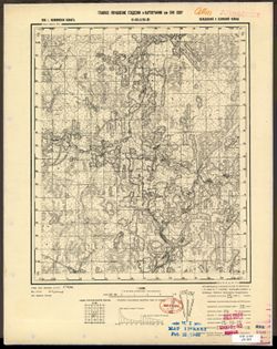
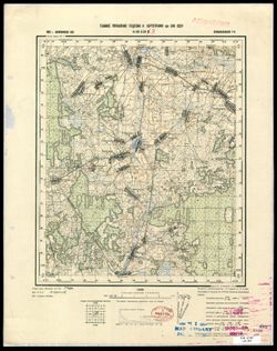
- 1938
- Subject:
- Topical Subject: Maps, Geographic Subject: Krasnogvardeyskoe, and Topical Subject: Soviet Union
- Publisher:
- Главное управление геодезии и картографии при СНК СССР
- Language:
- Russian
- Date Created:
- 1941
- Identifier:
- VAC9619-002343
- Genre:
- Topographic Maps and Military Maps
- Geographic Location:
- Coordinates: 45.667, 41.5, 46, 42
- Related URL:
- Download GeoTIFF: https://drive.google.com/file/d/1AVr-cwCpH2TyChEw-jxKdVkFJnNQ8ff2/view?usp=sharing and Catalog URL: https://iucat.iu.edu/catalog/5020129
- Abstract:
- Modern area represented: Krasnogvardeyskoe, Stavropol kray, Russia
- Call Number:
- G7000 s100 .S7 sheet L-37-84
- Caption:
- Для служебного пользования
- City:
- Молотовское (Molotovskoe)
- Copyright Holder:
- No Copyright - United States
- Country:
- СССР (USSR)
- State/Province:
- Орджоникидзевский край (Ordzhonikidze kray), Калмыцкая АССР (Kalmyk Autonomous Soviet Socialist Republic), Ростовская область (Rostov oblast), and РСФСР (RSFSR)
- Physical Description:
- Scale: 1:100,000
- Persistent URL:
- http://purl.dlib.indiana.edu/iudl/images/VAC9619/VAC9619-002343
- Provenance:
- DMA Topographic Center, Army Map Service Library, OMAHA
-
- Subject:
- Geographic Subject: Yasnogorsk, Topical Subject: Maps, and Topical Subject: Soviet Union
- Publisher:
- Главное управление геодезии и картографии при СНК СССР
- Language:
- Russian
- Date Created:
- 1941
- Identifier:
- VAC9619-003126
- Genre:
- Topographic Maps and Military Maps
- Geographic Location:
- Coordinates: 54.333, 37.5, 54.667, 38
- Related URL:
- Catalog URL: https://iucat.iu.edu/catalog/5020129 and Download GeoTIFF: https://drive.google.com/file/d/14yz9NxWnlBFIobdr2EFtwERelELXzTzE/view?usp=sharing
- Abstract:
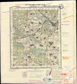
- Modern area represented: Ясногорск (Yasnogorsk), Tulskaya oblast, Russia
- Call Number:
- G7000 s100 .S7 sheet N-37-52
- Caption:
- Captured map
- City:
- Лаптево (Laptevo)
- Copyright Holder:
- No Copyright - United States
- Country:
- СССР (USSR)
- State/Province:
- Тульская область (Tula oblast) and РСФСР (RSFSR)
- Physical Description:
- Scale: 1:100,000
- Persistent URL:
- http://purl.dlib.indiana.edu/iudl/images/VAC9619/VAC9619-003126
- Provenance:
- DMA Topographic Center, Army Map Service Library, OMAHA, Library of Congress Geography & Map Division, Auswärtiges Amt. Geographischer Dienst
-
- Description:
- 1938
- Subject:
- Topical Subject: Soviet Union, Topical Subject: Maps, and Geographic Subject: Ponornitsa
- Publisher:
- Главное управление геодезии и картографии при СНК СССР
- Language:
- Russian
- Date Created:
- 1941
- Identifier:
- VAC9619-003258
- Genre:
- Topographic Maps and Military Maps
- Geographic Location:
- Coordinates: 51.667, 32.5, 52, 33
- Related URL:
- Download GeoTIFF: https://drive.google.com/file/d/1jcMqiw4doviC_niimFRwaVdI-Gcl6YTQ/view?usp=sharing and Catalog URL: https://iucat.iu.edu/catalog/5020129
- Abstract:
- Modern area represented: Ponornitsa, Chernihiv oblast, Ukraine
- Call Number:
- G7000 s100 .S7 sheet M-36-6
- City:
- Понорница (Ponornitsa)
- Copyright Holder:
- No Copyright - United States
- Country:
- СССР (USSR)
- State/Province:
- Черниговская область (Chernihiv oblast) and Украинская ССР (Ukrainian Soviet Socialist Republic)
- Physical Description:
- Scale: 1:100,000
- Persistent URL:
- http://purl.dlib.indiana.edu/iudl/images/VAC9619/VAC9619-003258
- Provenance:
- DMA Topographic Center, Army Map Service Library, OMAHA, Auswärtiges Amt. Geographischer Dienst
-
- Description:
- 1940
- Subject:
- Geographic Subject: Rylsk, Topical Subject: Maps, and Topical Subject: Soviet Union
- Publisher:
- Главное управление геодезии и картографии при СНК СССР
- Language:
- Russian
- Date Created:
- 1941
- Identifier:
- VAC9619-003268
- Genre:
- Military Maps and Topographic Maps
- Geographic Location:
- Coordinates: 51.333, 34.5, 51.667, 35
- Related URL:
- Catalog URL: https://iucat.iu.edu/catalog/5020129 and Download GeoTIFF: https://drive.google.com/file/d/17nmbolXXII1wdPqY29439uOYc2Vuo4Bi/view?usp=sharing
- Abstract:
- Modern area represented: Rylsk, Kursk oblast, Russia
- Call Number:
- G7000 s100 .S7 sheet M-36-22
- City:
- Рыльск (Rylsk)
- Copyright Holder:
- No Copyright - United States
- Country:
- СССР (USSR)
- State/Province:
- РСФСР (RSFSR) and Курская область (Kursk oblast)
- Physical Description:
- Scale: 1:100,000
- Persistent URL:
- http://purl.dlib.indiana.edu/iudl/images/VAC9619/VAC9619-003268
- Provenance:
- DMA Topographic Center, Army Map Service Library, OMAHA, Library of Congress Geography & Map Division, Auswärtiges Amt. Geographischer Dienst
-
- Description:
- 1936
- Subject:
- Topical Subject: Maps, Geographic Subject: Stepnaya, and Topical Subject: Soviet Union
- Publisher:
- Главное управление геодезии и картографии при СНК СССР
- Language:
- Russian
- Date Created:
- 1941
- Identifier:
- VAC9619-002337
- Genre:
- Topographic Maps and Military Maps
- Geographic Location:
- Coordinates: 45.667, 38, 46, 38.5
- Related URL:
- Catalog URL: https://iucat.iu.edu/catalog/5020129 and Download GeoTIFF: https://drive.google.com/file/d/1JbpHtvnICqALvD_ZX180f74-4Ca2Qrxr/view?usp=sharing
- Abstract:
- Modern area represented: Stepnaya, Russia
- Call Number:
- G7000 s100 .S7 sheet L-37-77
- Caption:
- Для служебного пользования
- City:
- Степная (Stepnaya)
- Copyright Holder:
- No Copyright - United States
- Country:
- СССР (USSR)
- State/Province:
- Краснодарский край (Krasnodar kray) and РСФСР (RSFSR)
- Physical Description:
- Scale: 1:100,000
- Persistent URL:
- http://purl.dlib.indiana.edu/iudl/images/VAC9619/VAC9619-002337
- Provenance:
- DMA Topographic Center, Army Map Service Library
-
- Description:
- 1937
- Subject:
- Topical Subject: Soviet Union, Geographic Subject: Budogoshch, and Topical Subject: Maps
- Publisher:
- Главное управление геодезии и картографии при СНК СССР
- Language:
- Russian
- Date Created:
- 1941
- Identifier:
- VAC9619-002131
- Genre:
- Military Maps and Topographic Maps
- Geographic Location:
- Coordinates: 59, 32, 59.3333, 32.5
- Related URL:
- Download GeoTIFF: https://drive.google.com/open?id=1YSF-556lOfBtGACCO2UvI9SSrGDDkMYN and Catalog URL: https://iucat.iu.edu/catalog/5020129
- Abstract:
- Modern area represented: Budogoshch, Russia
- Call Number:
- G7000 s100 .S7 sheet O-36-29
- Caption:
- Для служебного пользования
- City:
- Будогощь (Budogoshch)
- Copyright Holder:
- No Copyright - United States
- Country:
- СССР (USSR)
- State/Province:
- Чудовский район (Chudovsky district), Ленинградская область (Leningrad oblast), РСФСР (RSFSR), Киришский район (Kirishsky district), and Маловишерский район ...
- Physical Description:
- Scale: 1:100,000
- Persistent URL:
- http://purl.dlib.indiana.edu/iudl/images/VAC9619/VAC9619-002131
- Provenance:
- Army Map Service Library, Library of Congress G & M Division
-
- Description:
- 1936
- Subject:
- Topical Subject: Soviet Union, Topical Subject: Maps, and Geographic Subject: Nebolchi
- Publisher:
- Главное управление геодезии и картографии при СНК СССР
- Language:
- Russian
- Date Created:
- 1941
- Identifier:
- VAC9619-002133
- Genre:
- Topographic Maps and Military Maps
- Geographic Location:
- Coordinates: 59, 33, 59.3333, 33.5
- Related URL:
- Catalog URL: https://iucat.iu.edu/catalog/5020129 and Download GeoTIFF: https://drive.google.com/open?id=1U5gzlSz2a1NCAv6mDxB8Jh7sfuf3e5mI
- Abstract:
- Modern area represented: Неболчи (Nebolchi), Novgorodskaya oblast, Russia
- Call Number:
- G7000 s100 .S7 sheet O-36-31
- Caption:
- Для служебного пользования
- City:
- Неболчи (Nebolchi)
- Copyright Holder:
- No Copyright - United States
- Country:
- СССР (USSR)
- State/Province:
- Ленинградская область (Leningrad oblast) and РСФСР (RSFSR)
- Physical Description:
- Scale: 1:100,000
- Persistent URL:
- http://purl.dlib.indiana.edu/iudl/images/VAC9619/VAC9619-002133
- Provenance:
- DMA Topographic Center, Army Map Service Library, Library of Congress G & M Division
-
- Description:
- 1939
- Subject:
- Geographic Subject: Il’yushino, Topical Subject: Maps, and Topical Subject: Soviet Union
- Publisher:
- Главное управление геодезии и картографии при СНК СССР
- Language:
- Russian
- Date Created:
- 1941
- Identifier:
- VAC9619-003468
- Genre:
- Military Maps and Topographic Maps
- Geographic Location:
- Coordinates: 56.333, 32.5, 56.5, 32.75
- Related URL:
- Catalog URL: http://iucat.iu.edu/catalog/5020131 and Download GeoTIFF: https://drive.google.com/file/d/1gFCKXL3LEEV_HoW5baG2udOZMvB2T_-c/view?usp=sharing
- Abstract:
- Modern area represented: Ильюшино (Il’yushino), Tverskaya oblast, Russia
- Call Number:
- G7000 s50 .S68 sheet O-36-126-C
- City:
- Ильюшино (Il’yushino)
- Copyright Holder:
- No Copyright - United States
- Country:
- СССР (USSR)
- State/Province:
- Нелидовский район (Nelidovsky district), Калининская область (Kalinin oblast), and Ленинский район (Leninsky district)
- Physical Description:
- Scale: 1:50,000
- Persistent URL:
- http://purl.dlib.indiana.edu/iudl/images/VAC9619/VAC9619-003468
- Provenance:
- M. I. Map Library, Library of Congress Geography & Map Division
-
- Description:
- 1938
- Subject:
- Topical Subject: Soviet Union, Topical Subject: Maps, and Geographic Subject: Novoselki
- Publisher:
- Главное управление геодезии и картографии при СНК СССР
- Language:
- Russian
- Date Created:
- 1941
- Identifier:
- VAC9619-003506
- Genre:
- Military Maps and Topographic Maps
- Geographic Location:
- Coordinates: 56, 33.5, 56.167, 33.75
- Related URL:
- Catalog URL: http://iucat.iu.edu/catalog/5020131 and Download GeoTIFF: https://drive.google.com/file/d/1vVOP92j0feg7jZkHpknICQM830yuWRdh/view?usp=sharing
- Abstract:
- Modern area represented: Новоселки (Novoselki), Tverskaya oblast, Russia
- Call Number:
- GM G7000 s50 .S68 sheet O-36-140-C
- City:
- Новоселки (Novoselki)
- Copyright Holder:
- No Copyright - United States
- Country:
- СССР (USSR)
- State/Province:
- Калининская область (Kalinin oblast) and Оленинский район (Oleninsky district)
- Physical Description:
- Scale: 1:50,000
- Persistent URL:
- http://purl.dlib.indiana.edu/iudl/images/VAC9619/VAC9619-003506
- Provenance:
- DMA Topographic Center, Army Map Service Library, OMAHA
-
- Description:
- 1939
- Subject:
- Topical Subject: Soviet Union, Topical Subject: Maps, and Geographic Subject: Voronezh
- Publisher:
- Главное управление геодезии и картографии при СНК СССР
- Language:
- Russian
- Date Created:
- 1941
- Identifier:
- VAC9619-003259
- Genre:
- Topographic Maps and Military Maps
- Geographic Location:
- Coordinates: 51.667, 33, 52, 33.5
- Related URL:
- Catalog URL: https://iucat.iu.edu/catalog/5020129 and Download GeoTIFF: https://drive.google.com/file/d/1wkzHfaQ0hqJWsSKZl0nr7EeOORHorj2j/view?usp=sharing
- Abstract:
- Modern area represented: Voronezh, Sumy oblast, Ukraine
- Call Number:
- G7000 s100 .S7 sheet M-36-7
- City:
- Воронеж (Voronezh)
- Copyright Holder:
- No Copyright - United States
- Country:
- СССР (USSR)
- State/Province:
- Украинская ССР (Ukrainian Soviet Socialist Republic), Сумская область (Sumy oblast), and Черниговская область (Chernihiv oblast)
- Physical Description:
- Scale: 1:100,000
- Persistent URL:
- http://purl.dlib.indiana.edu/iudl/images/VAC9619/VAC9619-003259
- Provenance:
- DMA Topographic Center, Army Map Service Library, OMAHA, Atlasblatt
-
- Description:
- 1938
- Subject:
- Geographic Subject: Pryamukhino, Topical Subject: Maps, and Topical Subject: Soviet Union
- Publisher:
- Главное управление геодезии и картографии при СНК СССР
- Language:
- Russian
- Date Created:
- 1941
- Identifier:
- VAC9619-002899
- Genre:
- Military Maps and Topographic Maps
- Geographic Location:
- Coordinates: 56.833, 34.25, 57, 34.5
- Related URL:
- Catalog URL: http://iucat.iu.edu/catalog/5020131 and Download GeoTIFF: https://drive.google.com/file/d/1wgoZ8GCh8qkMdSZsDU8QuxF15aFr0Ndj/view?usp=sharing
- Abstract:
- Modern area represented: Прямухино (Pryamukhino), Tverskaya oblast, Russia
- Call Number:
- GM G7000 s50 .S68 sheet O-36-117-В
- Caption:
- Для служебного пользования
- City:
- Прямухино (Pryamukhino)
- Copyright Holder:
- No Copyright - United States
- Country:
- СССР (USSR)
- State/Province:
- Калининская область (Kalinin oblast), Каменский район (Kamensky district), and Луковниковский район (Lukovnikovsky district)
- Physical Description:
- Scale: 1:50,000
- Persistent URL:
- http://purl.dlib.indiana.edu/iudl/images/VAC9619/VAC9619-002899
- Provenance:
- DMA Topographic Center, Army Map Service Library, OMAHA, Library of Congress Geography & Map Division
-
- Description:
- 1939
- Subject:
- Topical Subject: Soviet Union, Topical Subject: Maps, and Geographic Subject: Shuvayevo
- Publisher:
- Главное управление геодезии и картографии при СНК СССР
- Language:
- Russian
- Date Created:
- 1941
- Identifier:
- VAC9619-002891
- Genre:
- Topographic Maps and Military Maps
- Geographic Location:
- Coordinates: 56.833, 33, 57, 33.25
- Related URL:
- Download GeoTIFF: https://drive.google.com/file/d/13FWxkADRE7fKlwOO1oh0LeFe8xTQPSzX/view?usp=sharing and Catalog URL: http://iucat.iu.edu/catalog/5020131
- Abstract:
- Modern area represented: Шуваево (Shuvayevo), Tverskaya oblast, Russia
- Call Number:
- GM G7000 s50 .S68 sheet O-36-115-A
- Caption:
- Для служебного пользования
- City:
- Шуваево (Shuvayevo)
- Copyright Holder:
- No Copyright - United States
- Country:
- СССР (USSR)
- State/Province:
- Калининская область (Kalinin oblast) and РСФСР (RSFSR)
- Physical Description:
- Scale: 1:50,000
- Persistent URL:
- http://purl.dlib.indiana.edu/iudl/images/VAC9619/VAC9619-002891
- Provenance:
- DMA Topographic Center, Army Map Service Library, OMAHA, Library of Congress Geography & Map Division
-

- Description:
- 1937
- Subject:
- Geographic Subject: Lyuban, Topical Subject: Maps, and Topical Subject: Soviet Union
- Publisher:
- Главное управление геодезии и картографии при СНК СССР
- Language:
- Russian
- Date Created:
- 1941
- Identifier:
- VAC9619-000038
- Genre:
- Military Maps and Topographic Maps
- Geographic Location:
- Coordinates: 59.3333, 31.25, 59.5, 31.5
- Related URL:
- Catalog URL: http://iucat.iu.edu/catalog/5020131 and Download GeoTIFF: https://drive.google.com/open?id=1pCEJjO8p7ASUgF6_aNi1rh6126bkDjgo
- Abstract:
- Modern area represented: Lyuban, Russia
- Call Number:
- G7000 s50 .S68 sheet O-36-15-D
- Caption:
- Для служебного пользования,Captured map
- City:
- Любань (Lyuban)
- Copyright Holder:
- No Copyright - United States
- Country:
- СССР (USSR)
- State/Province:
- Ленинградская область (Leningrad oblast), Тосненский район (Tosnensky district), and РСФСР (RSFSR)
- Physical Description:
- Scale: 1:50,000
- Persistent URL:
- http://purl.dlib.indiana.edu/iudl/images/VAC9619/VAC9619-000038
- Provenance:
- DMA Topographic Center, Army Map Service Library, Library of Congress Geography & Map Division
-
- Description:
- 1939
- Subject:
- Geographic Subject: Dubrovki, Topical Subject: Maps, and Topical Subject: Soviet Union
- Publisher:
- Главное управление геодезии и картографии при СНК СССР
- Language:
- Russian
- Date Created:
- 1941
- Identifier:
- VAC9619-002893
- Genre:
- Military Maps and Topographic Maps
- Geographic Location:
- Coordinates: 56.667, 33, 56.833, 33.25
- Related URL:
- Catalog URL: http://iucat.iu.edu/catalog/5020131 and Download GeoTIFF: https://drive.google.com/file/d/11w3Bp0joUPKgvkQ2d6XuwvsEuh3saXCy/view?usp=sharing
- Abstract:
- Modern area represented: Дубровки (Dubrovki), Tverskaya oblast, Russia
- Call Number:
- GM G7000 s50 .S68 sheet O-36-115-C
- Caption:
- Для служебного пользования
- City:
- Дубровки (Dubrovki)
- Copyright Holder:
- No Copyright - United States
- Country:
- СССР (USSR)
- State/Province:
- Пеновский район (Penovsky district), Калининская область (Kalinin oblast), and Кировский район (Kirov district)
- Physical Description:
- Scale: 1:50,000
- Persistent URL:
- http://purl.dlib.indiana.edu/iudl/images/VAC9619/VAC9619-002893
- Provenance:
- DMA Topographic Center, Army Map Service Library, OMAHA, Library of Congress Geography & Map Division
-
- Description:
- 1938
- Subject:
- Topical Subject: Maps, Geographic Subject: Golenishchevo, and Topical Subject: Soviet Union
- Publisher:
- Главное управление геодезии и картографии при СНК СССР
- Language:
- Russian
- Date Created:
- 1941
- Identifier:
- VAC9619-002902
- Genre:
- Topographic Maps and Military Maps
- Geographic Location:
- Coordinates: 56.833, 35, 57, 35.25
- Related URL:
- Download GeoTIFF: https://drive.google.com/file/d/1VtibtoQxHRE70YG4v1Z_BmotZkR5tx_t/view?usp=sharing and Catalog URL: http://iucat.iu.edu/catalog/5020131
- Abstract:
- Modern area represented: Голенищево (Golenishchevo), Tverskaya oblast, Russia
- Call Number:
- GM G7000 s50 .S68 sheet O-36-119-A
- City:
- Голенищево (Golenishchevo)
- Copyright Holder:
- No Copyright - United States
- Country:
- СССР (USSR)
- State/Province:
- Медновский район (Mednovsky district), Калининская область (Kalinin oblast), Новоторжский район (Novotorzhsky district), and Высоковский район (Vysokovsky di...
- Physical Description:
- Scale: 1:50,000
- Persistent URL:
- http://purl.dlib.indiana.edu/iudl/images/VAC9619/VAC9619-002902
- Provenance:
- Army Map Service Library, OMAHA, Library of Congress Geography & Map Division
-
- Description:
- 1939
- Subject:
- Geographic Subject: Venev, Topical Subject: Maps, and Topical Subject: Soviet Union
- Publisher:
- Главное управление геодезии и картографии при СНК СССР
- Language:
- Russian
- Date Created:
- 1941
- Identifier:
- VAC9619-003127
- Genre:
- Military Maps and Topographic Maps
- Geographic Location:
- Coordinates: 54.333, 38, 54.667, 38.5
- Related URL:
- Catalog URL: https://iucat.iu.edu/catalog/5020129 and Download GeoTIFF: https://drive.google.com/file/d/1huo8223fKmqHNHQ73Boeu97sA0Aj_YEb/view?usp=sharing
- Abstract:
- Modern area represented: Венев (Venev), Tulskaya oblast, Russia
- Call Number:
- G7000 s100 .S7 sheet N-37-53
- Caption:
- Для cлужебного пользования
- City:
- Венев (Venev)
- Copyright Holder:
- No Copyright - United States
- Country:
- СССР (USSR)
- State/Province:
- Тульская область (Tula oblast), РСФСР (RSFSR), and Московская область (Moscow oblast)
- Physical Description:
- Scale: 1:100,000
- Persistent URL:
- http://purl.dlib.indiana.edu/iudl/images/VAC9619/VAC9619-003127
- Provenance:
- DMA Topographic Center, Army Map Service Library, OMAHA, Library of Congress Geography & Map Division
-
- Description:
- 1939
- Subject:
- Geographic Subject: Lyuban, Topical Subject: Maps, and Topical Subject: Soviet Union
- Publisher:
- Главное управление геодезии и картографии при СНК СССР
- Language:
- Russian
- Date Created:
- 1941
- Identifier:
- VAC9619-002124
- Genre:
- Military Maps and Topographic Maps
- Geographic Location:
- Coordinates: 59.3333, 31, 59.6667, 31.5
- Related URL:
- Download GeoTIFF: https://drive.google.com/open?id=1XoMqH9A81q94V0iQ2ZXQ0WNYxt3K5y4j and Catalog URL: https://iucat.iu.edu/catalog/5020129
- Abstract:
- Modern area represented: Lyuban, Leningrad oblast, Russia
- Call Number:
- G7000 s100 .S7 sheet O-36-15
- Caption:
- Для служебного пользования
- City:
- Любань (Lyuban)
- Copyright Holder:
- No Copyright - United States
- Country:
- СССР (USSR)
- State/Province:
- РСФСР (RSFSR) and Ленинградская область (Leningrad oblast)
- Physical Description:
- Scale: 1:100,000
- Persistent URL:
- http://purl.dlib.indiana.edu/iudl/images/VAC9619/VAC9619-002124
- Provenance:
- DMA Topographic Center, Army Map Service Library, OMAHA
-
- Description:
- 1930
- Subject:
- Geographic Subject: Ipatovo, Topical Subject: Soviet Union, and Topical Subject: Maps
- Publisher:
- Главное управление геодезии и картографии при СНК СССР
- Language:
- Russian
- Date Created:
- 1941
- Identifier:
- VAC9619-002075
- Genre:
- Topographic Maps and Military Maps
- Geographic Location:
- Coordinates: 45.6667, 42.5, 46, 43
- Related URL:
- Download GeoTIFF: https://drive.google.com/open?id=1uYm7E4Ln86KvT-Fc9-5nOxrUsVGDIYGe and Catalog URL: https://iucat.iu.edu/catalog/5020129
- Abstract:
- Modern area represented: Ipatovo, Stavropol kray, Russia
- Call Number:
- G7000 s100 .S7 sheet L-38-74
- Caption:
- Для служебного пользования
- City:
- Ипатово (Ipatovo)
- Copyright Holder:
- No Copyright - United States
- Country:
- СССР (USSR)
- State/Province:
- Калмыцкая АССР (Kalmyk Autonomous Soviet Socialist Republic), РСФСР (RSFSR), and Орджоникидзевский край (Ordzhonikidze kray)
- Physical Description:
- Scale: 1:100,000
- Persistent URL:
- http://purl.dlib.indiana.edu/iudl/images/VAC9619/VAC9619-002075
- Provenance:
- CIA Map Library
-

- Description:
- 1938
- Subject:
- Geographic Subject: Ramen'ye, Topical Subject: Soviet Union, and Topical Subject: Maps
- Publisher:
- Главное управление геодезии и картографии при СНК СССР
- Language:
- Russian
- Date Created:
- 1941
- Identifier:
- VAC9619-003473
- Genre:
- Topographic Maps and Military Maps
- Geographic Location:
- Coordinates: 56.333, 34, 56.5, 34.25
- Related URL:
- Download GeoTIFF: https://drive.google.com/file/d/1qh-E-lgJptpwG6nUxUBiR_gBwnFCrbrW/view?usp=sharing and Catalog URL: http://iucat.iu.edu/catalog/5020131
- Abstract:
- Modern area represented: Раменье (Ramen'ye), Tverskaya oblast, Russia
- Call Number:
- G7000 s50 .S68 sheet O-36-129-C
- City:
- Раменье (Ramen'ye)
- Copyright Holder:
- No Copyright - United States
- Country:
- СССР (USSR)
- State/Province:
- Луковниковский район (Lukovnikovsky district), Калининская область (Kalinin oblast), Молодотудский район (Molodotudsky district), and Ржевский район (Rzhevsk...
- Physical Description:
- Scale: 1:50,000
- Persistent URL:
- http://purl.dlib.indiana.edu/iudl/images/VAC9619/VAC9619-003473
- Provenance:
- DMA Topographic Center, Army Map Service Library, OMAHA, Library of Congress Geography & Map Division
-
- Description:
- 1939
- Subject:
- Topical Subject: Soviet Union, Geographic Subject: Vysokoye, and Topical Subject: Maps
- Publisher:
- Главное управление геодезии и картографии при СНК СССР
- Language:
- Russian
- Date Created:
- 1941
- Identifier:
- VAC9619-003470
- Genre:
- Topographic Maps and Military Maps
- Geographic Location:
- Coordinates: 56.333, 32.75, 56.5, 33
- Related URL:
- Download GeoTIFF: https://drive.google.com/file/d/12E5i-f2khtKqePPSxPnAOJT4oAAmYPRD/view?usp=sharing and Catalog URL: http://iucat.iu.edu/catalog/5020131
- Abstract:
- Modern area represented: Высокое (Vysokoye), Tverskaya oblast, Russia
- Call Number:
- G7000 s50 .S68 sheet O-36-126-D
- City:
- Высокое (Vysokoye)
- Copyright Holder:
- No Copyright - United States
- Country:
- СССР (USSR)
- State/Province:
- Нелидовский район (Nelidovsky district), Ленинский район (Leninsky district), Молодотудский район (Molodotudsky district), and Калининская область (Kalinin o...
- Physical Description:
- Scale: 1:50,000
- Persistent URL:
- http://purl.dlib.indiana.edu/iudl/images/VAC9619/VAC9619-003470
- Provenance:
- DMA Topographic Center, Army Map Service Library, OMAHA, Library of Congress Geography & Map Division
-
- Description:
- 1938
- Subject:
- Topical Subject: Soviet Union, Geographic Subject: Tysyatskoye, and Topical Subject: Maps
- Publisher:
- Главное управление геодезии и картографии при СНК СССР
- Language:
- Russian
- Date Created:
- 1941
- Identifier:
- VAC9619-002848
- Genre:
- Topographic Maps and Military Maps
- Geographic Location:
- Coordinates: 57, 34.25, 57.167, 34.5
- Related URL:
- Download GeoTIFF: https://drive.google.com/file/d/18o3IQmUtRccKjPuKL9e4V3ItSU5attPq/view?usp=sharing and Catalog URL: http://iucat.iu.edu/catalog/5020131
- Abstract:
- Modern area represented: Тысяцкое (Tysyatskoye), Тверская область (Tverskaya oblast), Russia
- Call Number:
- GM G7000 s50 .S68 sheet O-36-105-D
- Caption:
- Для служебного пользования and Captured map
- City:
- Тысяцкое (Tysyatskoye)
- Copyright Holder:
- No Copyright - United States
- Country:
- СССР (USSR)
- State/Province:
- Есеновичский район (Yesenovichsky district), Каменский район (Kamensky district), Новоторжский район (Novotorzhsky district), and Калининская область (Kalini...
- Physical Description:
- Scale: 1:50,000
- Persistent URL:
- http://purl.dlib.indiana.edu/iudl/images/VAC9619/VAC9619-002848
- Provenance:
- DMA Topographic Center, Army Map Service Library, OMAHA, Library of Congress Geography & Map Division
-
- Description:
- 1936
- Subject:
- Topical Subject: Maps, Geographic Subject: Svetlograd, and Topical Subject: Soviet Union
- Publisher:
- Главное управление геодезии и картографии при СНК СССР
- Language:
- Russian
- Date Created:
- 1941
- Identifier:
- VAC9619-002169
- Genre:
- Military Maps and Topographic Maps
- Geographic Location:
- Coordinates: 45, 42.5, 45.33333, 43
- Related URL:
- Catalog URL: https://iucat.iu.edu/catalog/5020129 and Download GeoTIFF: https://drive.google.com/open?id=1uFPKdptgUTl0ZXnLCivKm0m4gwI7N7YD
- Abstract:
- Modern area represented: Svetlograd, Stavropol kray, Russia
- Call Number:
- G7000 s100 .S7 sheet L-38-98
- Caption:
- Для служебного пользования
- City:
- Петровское (Petrovskoye)
- Copyright Holder:
- No Copyright - United States
- Country:
- СССР (USSR)
- State/Province:
- Орджоникидзевский край (Ordzhonikidze kray) and РСФСР (RSFSR)
- Physical Description:
- Scale: 1:100,000
- Persistent URL:
- http://purl.dlib.indiana.edu/iudl/images/VAC9619/VAC9619-002169
- Provenance:
- CIA Map Library
-
- Description:
- 1939
- Subject:
- Topical Subject: Maps, Topical Subject: Soviet Union, and Geographic Subject: Staritsa
- Publisher:
- Главное управление геодезии и картографии при СНК СССР
- Language:
- Russian
- Date Created:
- 1941
- Identifier:
- VAC9619-002834
- Genre:
- Military Maps and Topographic Maps
- Geographic Location:
- Coordinates: 57.167, 31.75, 57.333, 32
- Related URL:
- Catalog URL: http://iucat.iu.edu/catalog/5020131 and Download GeoTIFF: https://drive.google.com/file/d/1fl4L7GVIlX3UXBuwHrA6QVyThKUkZMBU/view?usp=sharing
- Abstract:
- Modern area represented: Старица (Staritsa), Марёвский район (Marevskiy Rayon), Новгородская область (Novgorodskaya oblast), Russia
- Call Number:
- GM G7000 s50 .S68 sheet O-36-100-B
- Caption:
- Captured map
- City:
- Старица (Staritsa)
- Copyright Holder:
- No Copyright - United States
- Country:
- СССР (USSR)
- State/Province:
- Ленинградская область (Leningrad oblast) and Молвотицкий район (Molvotitsky district)
- Physical Description:
- Scale: 1:50,000
- Persistent URL:
- http://purl.dlib.indiana.edu/iudl/images/VAC9619/VAC9619-002834
- Provenance:
- Army Map Service Library, OMAHA, Library of Congress Geography & Map Division
-
- Description:
- 1926
- Subject:
- Topical Subject: Soviet Union, Topical Subject: Maps, and Geographic Subject: Rostov
- Publisher:
- Главное управление геодезии и картографии при СНК СССР
- Language:
- Russian
- Date Created:
- 1941
- Identifier:
- VAC9619-002286
- Genre:
- Topographic Maps and Military Maps
- Geographic Location:
- Coordinates: 47, 39.5, 47.3333, 40
- Related URL:
- Catalog URL: https://iucat.iu.edu/catalog/5020129 and Download GeoTIFF: https://drive.google.com/file/d/1XcqLQR-DzZL4b2V2aY4UGhly62ywbl77/view?usp=sharing
- Abstract:
- Modern area represented: Rostov, Russia
- Call Number:
- G7000 s100 .S7 sheet L-37-32
- Caption:
- Для служебного пользования
- City:
- Ростов (Rostov)
- Copyright Holder:
- No Copyright - United States
- Country:
- СССР (USSR)
- State/Province:
- Ростовская область (Rostov oblast) and РСФСР (RSFSR)
- Physical Description:
- Scale: 1:100,000
- Persistent URL:
- http://purl.dlib.indiana.edu/iudl/images/VAC9619/VAC9619-002286
- Provenance:
- DMA Topographic Center, Army Map Service Library
-
- Description:
- 1937
- Subject:
- Topical Subject: Soviet Union, Topical Subject: Maps, and Geographic Subject: Odoyev
- Publisher:
- Главное управление геодезии и картографии при СНК СССР
- Language:
- Russian
- Date Created:
- 1941
- Identifier:
- VAC9619-003140
- Genre:
- Military Maps and Topographic Maps
- Geographic Location:
- Coordinates: 53.667, 36.5, 54, 37
- Related URL:
- Download GeoTIFF: https://drive.google.com/file/d/1Rfcat4yYBKvRkGoglrTkSzSB3Rn_qvXI/view?usp=sharing and Catalog URL: https://iucat.iu.edu/catalog/5020129
- Abstract:
- Modern area represented: Одоев (Odoyev), Tulskaya oblast, Russia
- Call Number:
- G7000 s100 .S7 sheet N-37-74
- City:
- Одоево (Odoyevo)
- Copyright Holder:
- No Copyright - United States
- Country:
- СССР (USSR)
- State/Province:
- РСФСР (RSFSR) and Тульская область (Tula oblast)
- Physical Description:
- Scale: 1:100,000
- Persistent URL:
- http://purl.dlib.indiana.edu/iudl/images/VAC9619/VAC9619-003140
- Provenance:
- DMA Topographic Center, Army Map Service Library, OMAHA, Library of Congress Geography & Map Division, Geographic Names Branch
-
- Description:
- 1938
- Subject:
- Topical Subject: Soviet Union, Topical Subject: Maps, and Geographic Subject: Bol’shoye Ploskoye
- Publisher:
- Главное управление геодезии и картографии при СНК СССР
- Language:
- Russian
- Date Created:
- 1941
- Identifier:
- VAC9619-002850
- Genre:
- Topographic Maps and Military Maps
- Geographic Location:
- Coordinates: 57.167, 35.25, 57.333, 35.5
- Related URL:
- Catalog URL: http://iucat.iu.edu/catalog/5020131 and Download GeoTIFF: https://drive.google.com/file/d/1QbTVGhpTcwzq68sfhurfKNa6ZaCBc5b9/view?usp=sharing
- Abstract:
- Modern area represented: Большое Плоское (Bol’shoye Ploskoye), Тверская область (Tverskaya oblast), Russia
- Call Number:
- GM G7000 s50 .S68 sheet O-36-107-B
- Caption:
- Captured map
- City:
- Большое Плоское (Bol’shoye Ploskoye)
- Copyright Holder:
- No Copyright - United States
- Country:
- СССР (USSR)
- State/Province:
- Новоторжский район (Novotorzhsky district), Лихославльский район (Likhoslavlsky district), and Калининская область (Kalinin oblast)
- Physical Description:
- Scale: 1:50,000
- Persistent URL:
- http://purl.dlib.indiana.edu/iudl/images/VAC9619/VAC9619-002850
- Provenance:
- DMA Topographic Center, Army Map Service Library, OMAHA, Library of Congress Geography & Map Division
-

- Description:
- 1939
- Subject:
- Topical Subject: Maps, Geographic Subject: Vyshegorod, and Topical Subject: Soviet Union
- Publisher:
- Главное управление геодезии и картографии при СНК СССР
- Language:
- Russian
- Date Created:
- 1941
- Identifier:
- VAC9619-002897
- Genre:
- Military Maps and Topographic Maps
- Geographic Location:
- Coordinates: 56.6667, 33.5, 56.8333, 33.75
- Related URL:
- Catalog URL: http://iucat.iu.edu/catalog/5020131 and Download GeoTIFF: https://drive.google.com/file/d/1Yz4ZBUF-IvzvEjei_et63zhO83cB3S2-/view?usp=sharing
- Abstract:
- Modern area represented: Вышегород (Vyshegorod), Tverskaya oblast, Russia
- Call Number:
- GM G7000 s50 .S68 sheet О-36-116-C
- Caption:
- Для служебного пользования
- City:
- Вышегород (Vyshegorod)
- Copyright Holder:
- No Copyright - United States
- Country:
- СССР (USSR)
- State/Province:
- Калининская область (Kalinin oblast) and Кировский район (Kirov district)
- Physical Description:
- Scale: 1:50,000
- Persistent URL:
- http://purl.dlib.indiana.edu/iudl/images/VAC9619/VAC9619-002897
- Provenance:
- DMA Topographic Center, Army Map Service Library, OMAHA, Library of Congress Geography & Map Division
-
- Description:
- 1939
- Subject:
- Topical Subject: Soviet Union, Geographic Subject: Kolomna, and Topical Subject: Maps
- Publisher:
- Главное управление геодезии и картографии при СНК СССР
- Language:
- Russian
- Date Created:
- 1941
- Identifier:
- VAC9619-003094
- Genre:
- Military Maps and Topographic Maps
- Geographic Location:
- Coordinates: 55, 38.5, 55.333, 39
- Related URL:
- Catalog URL: https://iucat.iu.edu/catalog/5020129 and Download GeoTIFF: https://drive.google.com/file/d/1R-CkbwaDJZ-gIFEX3L5pDRh29r_POtHa/view?usp=sharing
- Abstract:
- Modern area represented: Kolomna, Moscow oblast, Russia
- Call Number:
- G7000 s100 .S7 sheet N-37-30
- Caption:
- Для служебного пользования
- City:
- Коломна (Kolomna)
- Copyright Holder:
- No Copyright - United States
- Country:
- СССР (USSR)
- State/Province:
- РСФСР (RSFSR) and Московская область (Moscow oblast)
- Physical Description:
- Scale: 1:100,000
- Persistent URL:
- http://purl.dlib.indiana.edu/iudl/images/VAC9619/VAC9619-003094
- Provenance:
- DMA Topographic Center, Army Map Service Library, OMAHA, Library of Congress Geography & Map Division, Geographic Names Branch
-
- Description:
- 1939
- Subject:
- Topical Subject: Maps, Geographic Subject: Novoyuryevo, and Topical Subject: Soviet Union
- Publisher:
- Главное управление геодезии и картографии при СНК СССР
- Language:
- Russian
- Date Created:
- 1941
- Identifier:
- VAC9619-003155
- Genre:
- Topographic Maps and Military Maps
- Geographic Location:
- Coordinates: 53.333, 40.5, 53.667, 41
- Related URL:
- Catalog URL: https://iucat.iu.edu/catalog/5020129 and Download GeoTIFF: https://drive.google.com/file/d/1MFnYn_pEKen3UiH6Y-od_0ekRDE1T3j-/view?usp=sharing
- Abstract:
- Modern area represented: Novoyuryevo, Russia
- Call Number:
- G7000 s100 .S7 sheet N-37-94
- Caption:
- Captured map
- City:
- Новоюрьево (Novoyuryevo)
- Copyright Holder:
- No Copyright - United States
- Country:
- СССР (USSR)
- State/Province:
- Тамбовская область (Tambov oblast), Рязанская область (Ryazan oblast), and РСФСР (RSFSR)
- Physical Description:
- Scale: 1:100,000
- Persistent URL:
- http://purl.dlib.indiana.edu/iudl/images/VAC9619/VAC9619-003155
- Provenance:
- DMA Topographic Center, Army Map Service Library
-
- Description:
- 1939
- Subject:
- Topical Subject: Soviet Union, Geographic Subject: Khitino, and Topical Subject: Maps
- Publisher:
- Главное управление геодезии и картографии при СНК СССР
- Language:
- Russian
- Date Created:
- 1941
- Identifier:
- VAC9619-002840
- Genre:
- Topographic Maps and Military Maps
- Geographic Location:
- Coordinates: 57, 32.75, 57.167, 33
- Related URL:
- Catalog URL: http://iucat.iu.edu/catalog/5020131 and Download GeoTIFF: https://drive.google.com/file/d/13eMfofnRHi-hf1T0ZA2QwUnPBArwXQY_/view?usp=sharing
- Abstract:
- Modern area represented: Хитино (Khitino), Тверская область (Tverskaya oblast), Russia
- Call Number:
- GM G7000 s50 .S68 sheet O-36-102-D
- Caption:
- Для служебного пользования
- City:
- Хитино (Khitino)
- Copyright Holder:
- No Copyright - United States
- Country:
- СССР (USSR)
- State/Province:
- Пеновский район (Penovsky district), Осташковский район (Ostashkovsky district), and Калининская область (Kalinin oblast)
- Physical Description:
- Scale: 1:50,000
- Persistent URL:
- http://purl.dlib.indiana.edu/iudl/images/VAC9619/VAC9619-002840
- Provenance:
- DMA Topographic Center, Army Map Service Library, OMAHA, Library of Congress Geography & Map Division, Geographic Names Branch
-
- Description:
- 1938
- Subject:
- Geographic Subject: Feryazkino, Topical Subject: Soviet Union, and Topical Subject: Maps
- Publisher:
- Главное управление геодезии и картографии при СНК СССР
- Language:
- Russian
- Date Created:
- 1941
- Identifier:
- VAC9619-003478
- Genre:
- Topographic Maps and Military Maps
- Geographic Location:
- Coordinates: 56.333, 35.75, 56.5, 36
- Related URL:
- Catalog URL: http://iucat.iu.edu/catalog/5020131 and Download GeoTIFF: https://drive.google.com/file/d/17W365JTid2GpJ9Vsdxn-jOk35JchUcHB/view?usp=sharing
- Abstract:
- Modern area represented: Ферязкино (Feryazkino), Tverskaya oblast, Russia
- Call Number:
- G7000 s50 .S68 sheet O-36-132-D
- City:
- Большое Ферязкино (Bol’shoye Feryazkino)
- Copyright Holder:
- No Copyright - United States
- Country:
- СССР (USSR)
- State/Province:
- Лотошинский район (Lotoshinsky district), Московская область (Moscow oblast), Калининская область (Kalinin oblast), and Тургиновский район (Turginovsky distr...
- Physical Description:
- Scale: 1:50,000
- Persistent URL:
- http://purl.dlib.indiana.edu/iudl/images/VAC9619/VAC9619-003478
- Provenance:
- DMA Topographic Center, Army Map Service Library, Library of Congress Geography & Map Division
-
- Description:
- 1939
- Subject:
- Topical Subject: Maps, Topical Subject: Soviet Union, and Geographic Subject: Grylevo
- Publisher:
- Главное управление геодезии и картографии при СНК СССР
- Language:
- Russian
- Date Created:
- 1941
- Identifier:
- VAC9619-003469
- Genre:
- Military Maps and Topographic Maps
- Geographic Location:
- Coordinates: 56.5, 32.75, 56.667, 33
- Related URL:
- Download GeoTIFF: https://drive.google.com/file/d/1QjGmO0DeaIwByion1ZVfgkNgLjktqFbW/view?usp=sharing and Catalog URL: http://iucat.iu.edu/catalog/5020131
- Abstract:
- Modern area represented: Грылево (Grylevo), Tverskaya oblast, Russia
- Call Number:
- G7000 s50 .S68 sheet O-36-126-B
- City:
- Грылево (Grylevo)
- Copyright Holder:
- No Copyright - United States
- Country:
- СССР (USSR)
- State/Province:
- Пеновский район (Penovsky district), Ленинский район (Leninsky district), Калининская область (Kalinin oblast), and Молодотудский район (Molodotudsky district)
- Physical Description:
- Scale: 1:50,000
- Persistent URL:
- http://purl.dlib.indiana.edu/iudl/images/VAC9619/VAC9619-003469
- Provenance:
- Army Map Service Library, OMAHA
-

- Description:
- 1939
- Subject:
- Geographic Subject: Felistovo, Topical Subject: Maps, and Topical Subject: Soviet Union
- Publisher:
- Главное управление геодезии и картографии при СНК СССР
- Language:
- Russian
- Date Created:
- 1941
- Identifier:
- VAC9619-002894
- Genre:
- Military Maps and Topographic Maps
- Geographic Location:
- Coordinates: 56.667, 33.25, 56.833, 33.5
- Related URL:
- Download GeoTIFF: https://drive.google.com/file/d/1e3n-bYV2JUuoXJS278EseNAJhPVS7Wyc/view?usp=sharing and Catalog URL: http://iucat.iu.edu/catalog/5020131
- Abstract:
- Modern area represented: Фелистово (Felistovo), Tverskaya oblast, Russia
- Call Number:
- GM G7000 s50 .S68 sheet O-36-115-D
- Caption:
- Для служебного пользования
- City:
- Фелистово (Felistovo)
- Copyright Holder:
- No Copyright - United States
- Country:
- СССР (USSR)
- State/Province:
- Кировский район (Kirov district) and Калининская область (Kalinin oblast)
- Physical Description:
- Scale: 1:50,000
- Persistent URL:
- http://purl.dlib.indiana.edu/iudl/images/VAC9619/VAC9619-002894
- Provenance:
- DMA Topographic Center, Army Map Service Library, OMAHA, Library of Congress Geography & Map Division
-
- Description:
- 1938
- Subject:
- Topical Subject: Soviet Union, Geographic Subject: Demyansk, and Topical Subject: Maps
- Publisher:
- Главное управление геодезии и картографии при СНК СССР
- Language:
- Russian
- Date Created:
- 1941
- Identifier:
- VAC9619-002186
- Genre:
- Topographic Maps and Military Maps
- Geographic Location:
- Coordinates: 57.3333, 32, 57.6667, 32.5
- Related URL:
- Catalog URL: https://iucat.iu.edu/catalog/5020129 and Download GeoTIFF: https://drive.google.com/open?id=1BZn8_6UHOHxS9rXqkXT9DxmFIAG4rdVd
- Abstract:
- Modern area represented: Демянск (Demyansk), Novgorodskaya oblast, Russia
- Call Number:
- G7000 s100 .S7 sheet O-36-89
- Caption:
- Для служебного пользования
- City:
- Демянск (Demyansk)
- Copyright Holder:
- No Copyright - United States
- Country:
- СССР (USSR)
- State/Province:
- Ленинградская область (Leningrad oblast) and РСФСР (RSFSR)
- Physical Description:
- Scale: 1:100,000
- Persistent URL:
- http://purl.dlib.indiana.edu/iudl/images/VAC9619/VAC9619-002186
- Provenance:
- DMA Topographic Center, Army Map Service Library, OMAHA, Library of Congress Geography & Map Division
-
- Description:
- 1939
- Subject:
- Topical Subject: Soviet Union, Topical Subject: Maps, and Geographic Subject: Ostrov
- Publisher:
- Главное управление геодезии и картографии при СНК СССР
- Language:
- Russian
- Date Created:
- 1941
- Identifier:
- VAC9619-002957
- Genre:
- Military Maps and Topographic Maps
- Geographic Location:
- Coordinates: 60, 31.75, 60.167, 32
- Related URL:
- Catalog URL: http://iucat.iu.edu/catalog/5020131 and Download GeoTIFF: https://drive.google.com/file/d/17pBS93leK5HdBIyVCAHPECmK_QwD68KD/view?usp=sharing
- Abstract:
- Modern area represented: Ostrov, Russia
- Call Number:
- GM G7000 s50 .S68 sheet P-36-136-D
- Caption:
- Для служебного пользования
- City:
- Остров (Ostrov)
- Copyright Holder:
- No Copyright - United States
- Country:
- СССР (USSR)
- State/Province:
- Волховский район (Volkhov district), Мгинский район (Mginsky district), РСФСР (RSFSR), and Ленинградская область (Leningrad oblast)
- Physical Description:
- Scale: 1:50,000
- Persistent URL:
- http://purl.dlib.indiana.edu/iudl/images/VAC9619/VAC9619-002957
- Provenance:
- DMA Topographic Center, Army Map Service Library, OMAHA, Library of Congress Geography & Map Division
-
- Description:
- 1939
- Subject:
- Topical Subject: Soviet Union, Topical Subject: Maps, and Geographic Subject: Sopkovo
- Publisher:
- Главное управление геодезии и картографии при СНК СССР
- Language:
- Russian
- Date Created:
- 1941
- Identifier:
- VAC9619-002844
- Genre:
- Topographic Maps and Military Maps
- Geographic Location:
- Coordinates: 57, 33.75, 57.167, 34
- Related URL:
- Catalog URL: http://iucat.iu.edu/catalog/5020131 and Download GeoTIFF: https://drive.google.com/file/d/18FH-llDMmXXbl0gZPsN4umcqhipvl5E2/view?usp=sharing
- Abstract:
- Modern area represented: Сопково (Sopkovo), Тверская область (Tverskaya oblast), Russia
- Call Number:
- GM G7000 s50 .S68 sheet O-36-104-D
- Caption:
- Для служебного пользования
- City:
- Сапково (Sapkovo)
- Copyright Holder:
- No Copyright - United States
- Country:
- СССР (USSR)
- State/Province:
- Калининская область (Kalinin oblast), Каменский район (Kamensky district), Есеновичский район (Yesenovichsky district), Кировский район (Kirov district), and...
- Physical Description:
- Scale: 1:50,000
- Persistent URL:
- http://purl.dlib.indiana.edu/iudl/images/VAC9619/VAC9619-002844
- Provenance:
- DMA Topographic Center, Army Map Service Library, OMAHA, Library of Congress Geography & Map Division
-
- Description:
- 1935
- Subject:
- Geographic Subject: Beloomut, Topical Subject: Soviet Union, and Topical Subject: Maps
- Publisher:
- Главное управление геодезии и картографии при СНК СССР
- Language:
- Russian
- Date Created:
- 1941
- Identifier:
- VAC9619-003104
- Genre:
- Topographic Maps and Military Maps
- Geographic Location:
- Coordinates: 54.667, 39.5, 55, 40
- Related URL:
- Catalog URL: https://iucat.iu.edu/catalog/5020129 and Download GeoTIFF: https://drive.google.com/file/d/1ytSBhHkK0h6zsHI_yGAVMdzh18II2O-T/view?usp=sharing
- Abstract:
- Modern area represented: Beloomut, Russia
- Call Number:
- G7000 s100 .S7 sheet N-37-43
- Caption:
- Для служебного пользования
- City:
- Белоомут (Beloomut)
- Copyright Holder:
- No Copyright - United States
- Country:
- СССР (USSR)
- State/Province:
- РСФСР (RSFSR), Московская область (Moscow oblast), and Рязанская область (Ryazan oblast)
- Physical Description:
- Scale: 1:100,000
- Persistent URL:
- http://purl.dlib.indiana.edu/iudl/images/VAC9619/VAC9619-003104
- Provenance:
- DMA Topographic Center, Army Map Service Library, Geographic Names Branch
-
- Description:
- 1939
- Subject:
- Geographic Subject: Shishkovo, Topical Subject: Soviet Union, and Topical Subject: Maps
- Publisher:
- Главное управление геодезии и картографии при СНК СССР
- Language:
- Russian
- Date Created:
- 1941
- Identifier:
- VAC9619-002187
- Genre:
- Military Maps and Topographic Maps
- Geographic Location:
- Coordinates: 57.3333, 32.5, 57.6667, 33
- Related URL:
- Download GeoTIFF: https://drive.google.com/open?id=1t9eliFe23sv-tiuF09y-YiGhMD-CSu9x and Catalog URL: https://iucat.iu.edu/catalog/5020129
- Abstract:
- Modern area represented: Шишково (Shishkovo), Novgorodskaya oblast, Russia
- Call Number:
- G7000 s100 .S7 sheet O-36-90
- Caption:
- Для служебного пользования
- City:
- Шишково (Shishkovo)
- Copyright Holder:
- No Copyright - United States
- Country:
- СССР (USSR)
- State/Province:
- Калининская область (Kalinin oblast), РСФСР (RSFSR), and Ленинградская область (Leningrad oblast)
- Physical Description:
- Scale: 1:100,000
- Persistent URL:
- http://purl.dlib.indiana.edu/iudl/images/VAC9619/VAC9619-002187
- Provenance:
- DMA Topographic Center, Army Map Service Library, OMAHA, Library of Congress Geography & Map Division
-
- Description:
- 1938
- Subject:
- Topical Subject: Maps, Geographic Subject: Pavlikovo, and Topical Subject: Soviet Union
- Publisher:
- Главное управление геодезии и картографии при СНК СССР
- Language:
- Russian
- Date Created:
- 1941
- Identifier:
- VAC9619-003472
- Genre:
- Topographic Maps and Military Maps
- Geographic Location:
- Coordinates: 56.5, 34.25, 56.667, 34.5
- Related URL:
- Download GeoTIFF: https://drive.google.com/file/d/1cM86uH12YBkYFhQNZjwCtN7j02FCIzUX/view?usp=sharing and Catalog URL: http://iucat.iu.edu/catalog/5020131
- Abstract:
- Modern area represented: Павликово (Pavlikovo), Tverskaya oblast, Russia
- Call Number:
- G7000 s50 .S68 sheet O-36-129-B
- City:
- Павликово (Pavlikovo)
- Copyright Holder:
- No Copyright - United States
- Country:
- СССР (USSR)
- State/Province:
- Луковниковский район (Lukovnikovsky district) and Калининская область (Kalinin oblast)
- Physical Description:
- Scale: 1:50,000
- Persistent URL:
- http://purl.dlib.indiana.edu/iudl/images/VAC9619/VAC9619-003472
- Provenance:
- M. I. Map Library, Library of Congress Geography & Map Division
-
- Description:
- 1939
- Subject:
- Topical Subject: Soviet Union, Geographic Subject: Shuya, and Topical Subject: Maps
- Publisher:
- Главное управление геодезии и картографии при СНК СССР
- Language:
- Russian
- Date Created:
- 1941
- Identifier:
- VAC9619-002151
- Genre:
- Topographic Maps and Military Maps
- Geographic Location:
- Coordinates: 58, 33, 58.3333, 33.5
- Related URL:
- Catalog URL: https://iucat.iu.edu/catalog/5020129 and Download GeoTIFF: https://drive.google.com/open?id=12B3cJ_5IrjQRm_PXq7FKNN4Nd9o_O4NM
- Abstract:
- Modern area represented: Шуя (Shuya), Novgorodskaya oblast, Russia
- Call Number:
- G7000 s100 .S7 sheet O-36-67
- Caption:
- Captured map and Для служебного пользования
- City:
- Шуя (Shuya)
- Copyright Holder:
- No Copyright - United States
- Country:
- СССР (USSR)
- State/Province:
- РСФСР (RSFSR) and Ленинградская область (Leningrad oblast)
- Physical Description:
- Scale: 1:100,000
- Persistent URL:
- http://purl.dlib.indiana.edu/iudl/images/VAC9619/VAC9619-002151
- Provenance:
- DMA Topographic Center, Army Map Service Library, OMAHA, Library of Congress Geography & Map Division
-
- Description:
- 1938
- Subject:
- Geographic Subject: Likhoslavl', Topical Subject: Soviet Union, and Topical Subject: Maps
- Publisher:
- Главное управление геодезии и картографии при СНК СССР
- Language:
- Russian
- Date Created:
- 1941
- Identifier:
- VAC9619-002852
- Genre:
- Military Maps and Topographic Maps
- Geographic Location:
- Coordinates: 57, 35.25, 57.167, 35.5
- Related URL:
- Download GeoTIFF: https://drive.google.com/file/d/1_1d7nZrOWqXaKo7w86AM92cd9KGEpK5Y/view?usp=sharing and Catalog URL: http://iucat.iu.edu/catalog/5020131
- Abstract:
- Modern area represented: Лихославль (Likhoslavl'), Тверская область (Tverskaya oblast), Russia
- Call Number:
- GM G7000 s50 .S68 sheet O-36-107-D
- City:
- Лихославль (Likhoslavl')
- Copyright Holder:
- No Copyright - United States
- Country:
- СССР (USSR)
- State/Province:
- Новоторжский район (Novotorzhsky district), Лихославльский район (Likhoslavlsky district), Калининская область (Kalinin oblast), and Медновский район (Mednov...
- Physical Description:
- Scale: 1:50,000
- Persistent URL:
- http://purl.dlib.indiana.edu/iudl/images/VAC9619/VAC9619-002852
- Provenance:
- M. I. Map Library
-
- Description:
- 1936
- Subject:
- Geographic Subject: Takhta, Topical Subject: Soviet Union, and Topical Subject: Maps
- Publisher:
- Главное управление геодезии и картографии при СНК СССР
- Language:
- Russian
- Date Created:
- 1941
- Identifier:
- VAC9619-002074
- Genre:
- Topographic Maps and Military Maps
- Geographic Location:
- Coordinates: 45.6667, 42, 46, 42.5
- Related URL:
- Catalog URL: https://iucat.iu.edu/catalog/5020129 and Download GeoTIFF: https://drive.google.com/open?id=1ebwUSJqRRABKNvP7cBe4RJhm_MDJtD4M
- Abstract:
- Modern area represented: Takhta, Stavropol kray, Russia
- Call Number:
- G7000 s100 .S7 sheet L-38-73
- Caption:
- Для служебного пользования
- City:
- Тахта (Takhta)
- Copyright Holder:
- No Copyright - United States
- Country:
- СССР (USSR)
- State/Province:
- РСФСР (RSFSR), Орджоникидзевский край (Ordzhonikidze kray), and Калмыцкая АССР (Kalmyk Autonomous Soviet Socialist Republic)
- Physical Description:
- Scale: 1:100,000
- Persistent URL:
- http://purl.dlib.indiana.edu/iudl/images/VAC9619/VAC9619-002074
- Provenance:
- Geographic Names Branch, Library of Congress G & M Division
-
- Description:
- 1939
- Subject:
- Topical Subject: Soviet Union, Geographic Subject: Kokovkino, and Topical Subject: Maps
- Publisher:
- Главное управление геодезии и картографии при СНК СССР
- Language:
- Russian
- Date Created:
- 1941
- Identifier:
- VAC9619-002837
- Genre:
- Topographic Maps and Military Maps
- Geographic Location:
- Coordinates: 57.167, 32.5, 57.333, 32.75
- Related URL:
- Catalog URL: http://iucat.iu.edu/catalog/5020131 and Download GeoTIFF: https://drive.google.com/file/d/14OEiZ6HQvQugXqeydMOpnvxaMe3ARFWE/view?usp=sharing
- Abstract:
- Modern area represented: Коковкино (Kokovkino), Тверская область (Tverskaya oblast), Russia
- Call Number:
- GM G7000 s50 .S68 sheet O-36-102-A
- Caption:
- Для служебного пользования
- City:
- Коковкино (Kokovkino)
- Copyright Holder:
- No Copyright - United States
- Country:
- СССР (USSR)
- State/Province:
- Калининская область (Kalinin oblast), Осташковский район (Ostashkovsky district), Пеновский район (Penovsky district), Ленинградская область (Leningrad oblas...
- Physical Description:
- Scale: 1:50,000
- Persistent URL:
- http://purl.dlib.indiana.edu/iudl/images/VAC9619/VAC9619-002837
- Provenance:
- DMA Topographic Center, Army Map Service Library, OMAHA, Library of Congress Geography & Map Division, Geographic Names Branch
-
- Description:
- 1936
- Subject:
- Geographic Subject: Oktyabrskoye, Topical Subject: Maps, and Topical Subject: Soviet Union
- Publisher:
- Главное управление геодезии и картографии при СНК СССР
- Language:
- Russian
- Date Created:
- 1941
- Identifier:
- VAC9619-002160
- Genre:
- Military Maps and Topographic Maps
- Geographic Location:
- Coordinates: 45.3333, 42.5, 45.6667, 43
- Related URL:
- Catalog URL: https://iucat.iu.edu/catalog/5020129 and Download GeoTIFF: https://drive.google.com/open?id=1WkVt36FFEsQFL0DIUFDkyXz9u-WMgFlz
- Abstract:
- Modern area represented: Oktyabrskoye, Stavropol kray, Russia
- Call Number:
- G7000 s100 .S7 sheet L-38-86
- Caption:
- Для служебного пользования
- City:
- Книгинское (Kniginskoye)
- Copyright Holder:
- No Copyright - United States
- Country:
- СССР (USSR)
- State/Province:
- Орджоникидзевский край (Ordzhonikidze kray) and РСФСР (RSFSR)
- Physical Description:
- Scale: 1:100,000
- Persistent URL:
- http://purl.dlib.indiana.edu/iudl/images/VAC9619/VAC9619-002160
- Provenance:
- CIA Map Library
-
- Description:
- 1938
- Subject:
- Topical Subject: Maps, Topical Subject: Soviet Union, and Geographic Subject: Polomenitsy
- Publisher:
- Главное управление геодезии и картографии при СНК СССР
- Language:
- Russian
- Date Created:
- 1941
- Identifier:
- VAC9619-002904
- Genre:
- Military Maps and Topographic Maps
- Geographic Location:
- Coordinates: 56.667, 35, 56.833, 35.25
- Related URL:
- Catalog URL: http://iucat.iu.edu/catalog/5020131 and Download GeoTIFF: https://drive.google.com/file/d/1_WPD2YySqDnn5ZOBE2eLEB6FMHHGimLb/view?usp=sharing
- Abstract:
- Modern area represented: Поломеницы (Polomenitsy), Tverskaya oblast, Russia
- Call Number:
- GM G7000 s50 .S68 sheet O-36-119-C
- City:
- Поломеницы (Polomenitsy)
- Copyright Holder:
- No Copyright - United States
- Country:
- СССР (USSR)
- State/Province:
- Емельяновский район (Yemelyanovsky district), Высоковский район (Vysokovsky district), Медновский район (Mednovsky district), and Калининская область (Kalini...
- Physical Description:
- Scale: 1:50,000
- Persistent URL:
- http://purl.dlib.indiana.edu/iudl/images/VAC9619/VAC9619-002904
- Provenance:
- M. I. Map Library
-
- Description:
- 1938
- Subject:
- Topical Subject: Maps, Geographic Subject: Plotnikovo, and Topical Subject: Soviet Union
- Publisher:
- Главное управление геодезии и картографии при СНК СССР
- Language:
- Russian
- Date Created:
- 1941
- Identifier:
- VAC9619-003474
- Genre:
- Military Maps and Topographic Maps
- Geographic Location:
- Coordinates: 56.333, 34.25, 56.5, 34.5
- Related URL:
- Catalog URL: http://iucat.iu.edu/catalog/5020131 and Download GeoTIFF: https://drive.google.com/file/d/1rtSI05x2OGdyNyY9GkpIk8olI5V_zoPE/view?usp=sharing
- Abstract:
- Modern area represented: Плотниково (Plotnikovo), Tverskaya oblast, Russia
- Call Number:
- G7000 s50 .S68 sheet O-36-129-D
- City:
- Плотниково (Plotnikovo)
- Copyright Holder:
- No Copyright - United States
- Country:
- СССР (USSR)
- State/Province:
- Ржевский район (Rzhevsky district), Калининская область (Kalinin oblast), and Луковниковский район (Lukovnikovsky district)
- Physical Description:
- Scale: 1:50,000
- Persistent URL:
- http://purl.dlib.indiana.edu/iudl/images/VAC9619/VAC9619-003474
- Provenance:
- DMA Topographic Center, Army Map Service Library, OMAHA, Library of Congress Geography & Map Division
-
- Description:
- 1939
- Subject:
- Topical Subject: Maps, Geographic Subject: Torbino, and Topical Subject: Soviet Union
- Publisher:
- Главное управление геодезии и картографии при СНК СССР
- Language:
- Russian
- Date Created:
- 1941
- Identifier:
- VAC9619-003374
- Genre:
- Military Maps and Topographic Maps
- Geographic Location:
- Coordinates: 58.5, 32.75, 58.667, 33
- Related URL:
- Download GeoTIFF: https://drive.google.com/file/d/1REcpv4d51hjjI3DlbpCjUEu2PCsUgHsu/view?usp=sharing and Catalog URL: http://iucat.iu.edu/catalog/5020131
- Abstract:
- Modern area represented: Торбино (Torbino), Novgorodskaya oblast, Russia
- Call Number:
- G7000 s50 .S68 sheet O-36-54-B
- Caption:
- Для служебного пользования and Captured map
- City:
- Торбино (Torbino)
- Copyright Holder:
- No Copyright - United States
- Country:
- СССР (USSR)
- State/Province:
- Ленинградская область (Leningrad oblast)
- Physical Description:
- Scale: 1:50,000
- Persistent URL:
- http://purl.dlib.indiana.edu/iudl/images/VAC9619/VAC9619-003374
- Provenance:
- DMA Topographic Center, Army Map Service Library, OMAHA, Library of Congress Geography & Map Division
-
- Description:
- 1939
- Subject:
- Topical Subject: Soviet Union, Geographic Subject: Moshenskoye, and Topical Subject: Maps
- Publisher:
- Главное управление геодезии и картографии при СНК СССР
- Language:
- Russian
- Date Created:
- 1941
- Identifier:
- VAC9619-002147
- Genre:
- Topographic Maps and Military Maps
- Geographic Location:
- Coordinates: 58.3333, 34.5, 58.6667, 35
- Related URL:
- Catalog URL: https://iucat.iu.edu/catalog/5020129 and Download GeoTIFF: https://drive.google.com/open?id=1H1PDXO20HVacaK1QpFLYROOYQkRPAt9M
- Abstract:
- Modern area represented: Мошенское (Moshenskoye), Novgorodskaya oblast, Russia
- Call Number:
- G7000 s100 .S7 sheet O-36-58
- Caption:
- Captured map
- City:
- Мошенское (Moshenskoye)
- Copyright Holder:
- No Copyright - United States
- Country:
- СССР (USSR)
- State/Province:
- Ленинградская область (Leningrad oblast) and РСФСР (RSFSR)
- Physical Description:
- Scale: 1:100,000
- Persistent URL:
- http://purl.dlib.indiana.edu/iudl/images/VAC9619/VAC9619-002147
- Provenance:
- DMA Topographic Center, Army Map Service Library, OMAHA, Library of Congress Geography & Map Division
-
- Description:
- 1938
- Subject:
- Topical Subject: Maps, Topical Subject: Soviet Union, and Geographic Subject: Sloboda
- Publisher:
- Главное управление геодезии и картографии при СНК СССР
- Language:
- Russian
- Date Created:
- 1941
- Identifier:
- VAC9619-003514
- Genre:
- Topographic Maps and Military Maps
- Geographic Location:
- Coordinates: 56.333, 36.75, 56.5, 37
- Related URL:
- Download GeoTIFF: https://drive.google.com/file/d/1FIM5aUANKvW41Va_K16TJ3TTeA1rgXmo/view?usp=sharing and Catalog URL: http://iucat.iu.edu/catalog/5020131
- Abstract:
- Modern area represented: Sloboda, Russia
- Call Number:
- GM G7000 s50 .S68 sheet O-37-122-D
- City:
- Слобода (Sloboda)
- Copyright Holder:
- No Copyright - United States
- Country:
- СССР (USSR)
- State/Province:
- Солнечногорский район (Solnechnogorsky district), Клинский район (Klinsky district), and Московская область (Moscow oblast)
- Physical Description:
- Scale: 1:50,000
- Persistent URL:
- http://purl.dlib.indiana.edu/iudl/images/VAC9619/VAC9619-003514
- Provenance:
- DMA Topographic Center, Army Map Service Library, OMAHA, Library of Congress Geography & Map Division
-
- Description:
- 1939
- Subject:
- Topical Subject: Soviet Union, Topical Subject: Maps, and Geographic Subject: Kravotyn'
- Publisher:
- Главное управление геодезии и картографии при СНК СССР
- Language:
- Russian
- Date Created:
- 1941
- Identifier:
- VAC9619-002841
- Genre:
- Topographic Maps and Military Maps
- Geographic Location:
- Coordinates: 57.167, 33, 57.333, 33.25
- Related URL:
- Download GeoTIFF: https://drive.google.com/file/d/1ES4pkCBJt5r7GmAOEju7JNpB3uXWh-H0/view?usp=sharing and Catalog URL: http://iucat.iu.edu/catalog/5020131
- Abstract:
- Modern area represented: Кравотынь (Kravotyn'), Тверская область (Tverskaya oblast), Russia
- Call Number:
- GM G7000 s50 .S68 sheet O-36-103-A
- Caption:
- Captured map and Для служебного пользования
- City:
- Кравотынь (Kravotyn')
- Copyright Holder:
- No Copyright - United States
- Country:
- СССР (USSR)
- State/Province:
- Калининская область (Kalinin oblast) and Осташковский район (Ostashkovsky district)
- Physical Description:
- Scale: 1:50,000
- Persistent URL:
- http://purl.dlib.indiana.edu/iudl/images/VAC9619/VAC9619-002841
- Provenance:
- DMA Topographic Center, Army Map Service Library, Library of Congress Geography & Map Division

- « Previous
- Next »
- 1
- 2
- 3
- 4