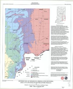
"This map data was compiled in 1997 from information available at the time, but was unpublished until until 2002, the map does not reflect any changes i...
Topical Subject: Caves, Geographic Subject: Indiana, Topical Subject: Springs, Topical Subject: Sinkholes, and Topical Subject: Karst
Creator:
Powell, Richard L.
Publisher:
Indiana. Geological Survey
Date Created:
2002
Identifier:
VAC3073-M-00135
Genre:
Geological maps
Geographic Location:
Coordinates: W0870002 W0854608 N0394722 N0375826
Related URL:
Catalog URL: https://iucat.iu.edu/catalog/5325676
Abstract:
"This map data was compiled in 1997 from information available at the time, but was unpublished until until 2002, the map does not reflect any changes i...
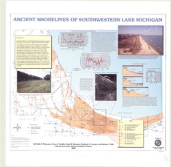
Geographic Subject: Porter County (Ind.), Geographic Subject: Indiana, Geographic Subject: Michigan, Lake, Coast (Ind.), Topical Subject: Lakes, Topical Subj...
Creator:
Thompson, Todd A. (Todd Alan), 1959-
Publisher:
Indiana. Geological Survey
Date Created:
2000
Identifier:
VAC3073-M-00193
Genre:
Thematic maps
Geographic Location:
Coordinates: W0873136 W0871307 N0414539 N0410943
Related URL:
Catalog URL: https://iucat.iu.edu/catalog/4898581
Abstract:
Includes illustrations, text, graphs showing "Lake-level fluctuations over the past 4,700 years" and a timeline showing historical events since 116...
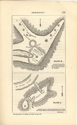
At head of first title: Plate H , At head of second title: Plate I. Relief shown by hachures and spot heights. Shows prehistoric forts [Miami Fort and Oberti...
Call Number:
QE109 .A2
Caption:
Imprint: [Indianapolis] : [Geological Survey of Indiana], [1879] and Imprint: [Indianapolis] : [Indianapolis Journal Company, State printers], [1879]
Physical Description:
Dimensions: 22 x 14 cm and Scale: Scale not given.
Alternate Identifier:
Title Control Number: a18387663 and Alternate ID: 390723IP
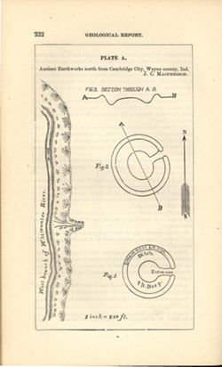
At head of title: Plate A. Relief shown by profile and spot heights. Includes pictorial map of west branch of Whitewater River and three figures showing heig...
Call Number:
G4094.C15E15 1878 .M33
Caption:
Imprint: [Indianapolis] : [Indianapolis Journal Company, State printers], [1879] and Imprint: [Indianapolis] : [Geological Survey of Indiana], [1879]
Physical Description:
Dimensions: on sheet 22 x 13 cm and Scale: Approximately 1:2,400. 1 inch = 200 ft.
Alternate Identifier:
Alternate ID: 390723IP and Title Control Number: a18387638
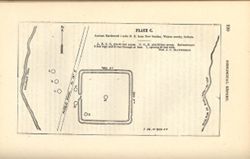
At head of title: Plate C. Shows streams, pits, and earthwork [Indiana Adena Square?] with measurements. Detached from: Eighth, ninth, and tenth annual re...
Call Number:
G4094.N438 1978 .M33
Caption:
Imprint: [Indianapolis] : [Indianapolis Journal Company, State printers], [1879] and Imprint: [Indianapolis] : [Geological Survey of Indiana], [1879]
Physical Description:
Dimensions: on sheet 14 x 21 cm and Scale: Approximately 1:6,000. 1 inch = 500 ft.
Alternate Identifier:
Alternate ID: 390723IP and Title Control Number: a18387636