
Search Constraints
You searched for:
Provenance
DMA Topographic Center, Army Map Service Library, Library of Congress Geography & Map Division
Remove constraint Provenance: DMA Topographic Center, Army Map Service Library, Library of Congress Geography & Map Division
« Previous |
1 - 50 of 273
|
Next »
Search Results
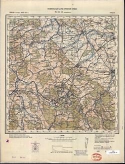
-
- Description:
- 1935
- Subject:
- Topical Subject: Maps, Geographic Subject: Alyaty, and Topical Subject: Soviet Union
- Publisher:
- Генеральный штаб РККА
- Language:
- Russian
- Identifier:
- VAC9619-000512
- Genre:
- Military Maps and Topographic Maps
- Geographic Location:
- Coordinates: 39.6667, 49, 40, 49.5
- Related URL:
- Download GeoTIFF: https://drive.google.com/open?id=1thXNAZgQOY6cyuKzY6_hqN1qSN1REE2m and Catalog URL: https://iucat.iu.edu/catalog/5020129
- Abstract:
- Modern area represented: Alyaty, Baku, Azerbaijan.
- Call Number:
- G7000 s100 .S7 sheet J-39-3
- Caption:
- Не подлежит оглашению
- City:
- Алят-Пристань (Alyat-Pristan)
- Copyright Holder:
- No Copyright - United States
- Country:
- СССР (USSR)
- State/Province:
- Азербайджанская ССР (Azerbaijan Soviet Socialist Republic)
- Physical Description:
- Scale: 1:100,000
- Persistent URL:
- http://purl.dlib.indiana.edu/iudl/images/VAC9619/VAC9619-000512
- Provenance:
- DMA Topographic Center, Army Map Service Library, Library of Congress Geography & Map Division
-
- Description:
- 1936
- Subject:
- Topical Subject: Soviet Union, Geographic Subject: Şǝki, and Topical Subject: Maps
- Publisher:
- Даг. Водхоз
- Language:
- Russian
- Identifier:
- VAC9619-000817
- Genre:
- Military Maps and Topographic Maps
- Geographic Location:
- Coordinates: 41, 47, 41.3333, 47.5
- Related URL:
- Catalog URL: https://iucat.iu.edu/catalog/5020129 and Download GeoTIFF: https://drive.google.com/open?id=1c6nxY2kfBPOUTDNfuEZcq4Tq78EEvbf7
- Abstract:
- Modern area represented: Şǝki, Azerbaijan
- Call Number:
- G7000 s100 .S7 sheet K-38-107
- Copyright Holder:
- No Copyright - United States
- Country:
- СССР (USSR)
- State/Province:
- Азербайджанская ССР (Azerbaijan Soviet Socialist Republic) and Дагестанская АССР (Dagestan Autonomous Soviet Socialist Republic)
- Physical Description:
- Scale: 1:100,000
- Persistent URL:
- http://purl.dlib.indiana.edu/iudl/images/VAC9619/VAC9619-000817
- Provenance:
- DMA Topographic Center, Army Map Service Library, Library of Congress Geography & Map Division
-
- Description:
- 1936
- Subject:
- Topical Subject: Maps, Geographic Subject: Xaçmaz, and Topical Subject: Soviet Union
- Publisher:
- Даг. Водхоз
- Language:
- Russian
- Identifier:
- VAC9619-000788
- Genre:
- Topographic Maps and Military Maps
- Geographic Location:
- Coordinates: 41, 47.5, 41.3333, 48
- Related URL:
- Download GeoTIFF: https://drive.google.com/open?id=1oAbQEfccsKQfpeydd9HG8SpzThNWvahL and Catalog URL: https://iucat.iu.edu/catalog/5020129
- Abstract:
- Modern area represented: Xaçmaz, Oğuz rayon, Azerbaijan
- Call Number:
- G7000 s100 .S7 sheet K-38-108
- Copyright Holder:
- No Copyright - United States
- Country:
- СССР (USSR)
- State/Province:
- Докузпаринский район (Dokuzparinsky district), Ахтынский район (Akhtynsky district), Азербайджанская ССР (Azerbaijan Soviet Socialist Republic), and Дагестан...
- Physical Description:
- Scale: 1:100,000
- Persistent URL:
- http://purl.dlib.indiana.edu/iudl/images/VAC9619/VAC9619-000788
- Provenance:
- DMA Topographic Center, Army Map Service Library, Library of Congress Geography & Map Division
-
- Description:
- 1886
- Subject:
- Topical Subject: Maps, Topical Subject: Soviet Union, and Geographic Subject: Zayukovo
- Publisher:
- Генеральный штаб Красной Армии
- Language:
- Russian
- Date Created:
- 1942
- Identifier:
- VAC9619-000768
- Genre:
- Military Maps and Topographic Maps
- Geographic Location:
- Coordinates: 43.3333, 43, 43.6667, 43.5
- Related URL:
- Download GeoTIFF: https://drive.google.com/open?id=1ZvJc3OHAg6vpcikjFr92BMG60irdKLJA and Catalog URL: https://iucat.iu.edu/catalog/5020129
- Abstract:
- Modern area represented: Zayukovo, Kabardino-Balkariya Republic, Russia
- Call Number:
- G7000 s100 .S7 sheet K-38-15
- Caption:
- Для служебного пользования
- City:
- Заюково (Zayukovo)
- Copyright Holder:
- No Copyright - United States
- Country:
- СССР (USSR)
- State/Province:
- РСФСР (RSFSR) and Кабардино-Балкарская АССР (Kabardino-Balkar Autonomous Soviet Socialist Republic)
- Physical Description:
- Scale: 1:100,000
- Persistent URL:
- http://purl.dlib.indiana.edu/iudl/images/VAC9619/VAC9619-000768
- Provenance:
- DMA Topographic Center, Army Map Service Library, Library of Congress Geography & Map Division
-
- Description:
- 1865
- Subject:
- Geographic Subject: Vladikavkaz, Topical Subject: Soviet Union, and Topical Subject: Maps
- Publisher:
- Генеральный штаб Красной Армии
- Language:
- Russian
- Date Created:
- 1942
- Identifier:
- VAC9619-000771
- Genre:
- Military Maps and Topographic Maps
- Geographic Location:
- Coordinates: 43, 44.5, 43.3333, 45
- Related URL:
- Catalog URL: https://iucat.iu.edu/catalog/5020129 and Download GeoTIFF: https://drive.google.com/open?id=1kDKKODnPr23wD5i0h8neJQlTz_2AADEd
- Abstract:
- Modern area represented: Vladikavkaz, North Ossetia, Russia
- Call Number:
- G7000 s100 .S7 sheet K-38-30
- Caption:
- Для служебного пользования
- City:
- Орджоникидзе (Ordzhonikidze)
- Copyright Holder:
- No Copyright - United States
- Country:
- СССР (USSR)
- State/Province:
- Северо-Осетинская АССР (North Ossetian Autonomous Soviet Socialist Republic), Чечено-Ингушская АССР (Checheno-Ingush Autonomous Soviet Socialist Republic), a...
- Physical Description:
- Scale: 1:100,000
- Persistent URL:
- http://purl.dlib.indiana.edu/iudl/images/VAC9619/VAC9619-000771
- Provenance:
- DMA Topographic Center, Army Map Service Library, Library of Congress Geography & Map Division
-
- Description:
- 1926
- Subject:
- Geographic Subject: Petropavlovskiy, Topical Subject: Soviet Union, and Topical Subject: Maps
- Publisher:
- Генеральный штаб Красной Армии
- Language:
- Russian
- Date Created:
- 1942
- Identifier:
- VAC9619-000776
- Genre:
- Military Maps and Topographic Maps
- Geographic Location:
- Coordinates: 43.6667, 43.5, 44, 44
- Related URL:
- Catalog URL: https://iucat.iu.edu/catalog/5020129 and Download GeoTIFF: https://drive.google.com/open?id=1dg7f6EBuVklTPJaZtvCy_PTDJEXMZyd5
- Abstract:
- Modern area represented: Petropavlovskiy, Kabardino-Balkariya republic, Russia
- Call Number:
- G7000 s100 .S7 sheet K-38-4
- Caption:
- Для служебного пользования
- City:
- Новопавловская (Petropavlovskaya)
- Copyright Holder:
- No Copyright - United States
- Country:
- СССР (USSR)
- State/Province:
- Орджоникидзевский край (Ordzhonikidze kray), Кабардино-Балкарская АССР (Kabardino-Balkar Autonomous Soviet Socialist Republic), and РСФСР (RSFSR)
- Physical Description:
- Scale: 1:100,000
- Persistent URL:
- http://purl.dlib.indiana.edu/iudl/images/VAC9619/VAC9619-000776
- Provenance:
- DMA Topographic Center, Army Map Service Library, Library of Congress Geography & Map Division
-
- Description:
- 1925
- Subject:
- Topical Subject: Maps, Geographic Subject: Prokhladniy, and Topical Subject: Soviet Union
- Publisher:
- Генеральный штаб Красной Армии
- Language:
- Russian
- Date Created:
- 1942
- Identifier:
- VAC9619-000808
- Genre:
- Topographic Maps and Military Maps
- Geographic Location:
- Coordinates: 43.6667, 44, 44, 44.5
- Related URL:
- Download GeoTIFF: https://drive.google.com/open?id=1OjKt08J0_fPt0XbJ57tpvB64eHbCRPc1 and Catalog URL: https://iucat.iu.edu/catalog/5020129
- Abstract:
- Modern area represented: Prokhladniy, Kabardino-Balkariya republic, Russia
- Call Number:
- G7000 s100 .S7 sheet K-38-5
- Caption:
- Секретно
- City:
- Прохладный (Prokhladniy)
- Copyright Holder:
- No Copyright - United States
- Country:
- СССР (USSR)
- State/Province:
- Орджоникидзевский край (Ordzhonikidze kray), РСФСР (RSFSR), and Кабардино-Балкарская АССР (Kabardino-Balkar Autonomous Soviet Socialist Republic)
- Physical Description:
- Scale: 1:100,000
- Persistent URL:
- http://purl.dlib.indiana.edu/iudl/images/VAC9619/VAC9619-000808
- Provenance:
- DMA Topographic Center, Army Map Service Library, Library of Congress Geography & Map Division
-
- Description:
- 1936
- Subject:
- Topical Subject: Maps and Topical Subject: Soviet Union
- Publisher:
- Даг. Водхоз
- Language:
- Russian
- Identifier:
- VAC9619-000772
- Genre:
- Topographic Maps and Military Maps
- Geographic Location:
- Coordinates: 41.3333, 47.5, 41.6667, 48
- Related URL:
- Download GeoTIFF: https://drive.google.com/open?id=1kQKHZZZPe8TQw3T5gDkNi8cCUREBa3cE and Catalog URL: https://iucat.iu.edu/catalog/5020129
- Call Number:
- G7000 s100 .S7 sheet K-38-96
- Copyright Holder:
- No Copyright - United States
- Country:
- СССР (USSR)
- State/Province:
- Ахтынский район (Akhtynsky district), Азербайджанская ССР (Azerbaijan Soviet Socialist Republic), Курахский район (Kurakhsky district), and Дагестанская АССР...
- Physical Description:
- Scale: 1:100,000
- Persistent URL:
- http://purl.dlib.indiana.edu/iudl/images/VAC9619/VAC9619-000772
- Provenance:
- DMA Topographic Center, Army Map Service Library, Library of Congress Geography & Map Division
-
- Description:
- 1900
- Subject:
- Topical Subject: Maps, Geographic Subject: Deva, and Topical Subject: Soviet Union
- Publisher:
- Генеральный штаб Красной Армии
- Language:
- Russian
- Date Created:
- 1940
- Identifier:
- VAC9619-001255
- Genre:
- Topographic Maps and Military Maps
- Geographic Location:
- Coordinates: 45.6667, 22.5, 46, 23
- Related URL:
- Download GeoTIFF: https://drive.google.com/open?id=15eZ-SSDrKDZRKb7EoGa8LOVMH1kY1aG8 and Catalog URL: https://iucat.iu.edu/catalog/5020129
- Abstract:
- Modern area represented: Deva, Hunedoara county, Romania
- Call Number:
- G7000 s100 .S7 sheet L-34-82
- City:
- Дева (Deva)
- Copyright Holder:
- No Copyright - United States
- Country:
- Румыния (Romania)
- Physical Description:
- Scale: 1:100,000
- Persistent URL:
- http://purl.dlib.indiana.edu/iudl/images/VAC9619/VAC9619-001255
- Provenance:
- DMA Topographic Center, Army Map Service Library, Library of Congress Geography & Map Division
-
- Description:
- 1891
- Subject:
- Topical Subject: Soviet Union, Topical Subject: Maps, and Geographic Subject: Ploieşti
- Publisher:
- Генеральный штаб Красной Армии
- Language:
- Russian
- Date Created:
- 1940
- Identifier:
- VAC9619-001710
- Genre:
- Military Maps and Topographic Maps
- Geographic Location:
- Coordinates: 44.6667, 26, 45, 26.5
- Related URL:
- Catalog URL: https://iucat.iu.edu/catalog/5020129 and Download GeoTIFF: https://drive.google.com/open?id=1kbO5Fn1_gAfzsDWVCBnsh83RvgIf2cLC
- Abstract:
- Modern area represented: Ploieşti, Prahova county, Romania
- Call Number:
- G7000 s100 .S7 sheet L-35-113
- City:
- Плоешти (Ploieşti)
- Copyright Holder:
- No Copyright - United States
- Country:
- Румыния (Romania)
- Physical Description:
- Scale: 1:100,000
- Persistent URL:
- http://purl.dlib.indiana.edu/iudl/images/VAC9619/VAC9619-001710
- Provenance:
- DMA Topographic Center, Army Map Service Library, Library of Congress Geography & Map Division
-
- Description:
- 1894
- Subject:
- Topical Subject: Maps, Geographic Subject: Tătaru, and Topical Subject: Soviet Union
- Publisher:
- Генеральный штаб Красной Армии
- Language:
- Russian
- Date Created:
- 1940
- Identifier:
- VAC9619-001756
- Genre:
- Military Maps and Topographic Maps
- Geographic Location:
- Coordinates: 44.6667, 27, 45, 27.5
- Related URL:
- Catalog URL: https://iucat.iu.edu/catalog/5020129 and Download GeoTIFF: https://drive.google.com/open?id=12-p_BHuRv8fuQGL5nfUTZsaVfPTWOkwj
- Abstract:
- Modern area represented: Tătaru, Brăila county, Romania
- Call Number:
- G7000 s100 .S7 sheet L-35-115
- City:
- Татару (Tătaru)
- Copyright Holder:
- No Copyright - United States
- Country:
- Румыния (Romania)
- Physical Description:
- Scale: 1:100,000
- Persistent URL:
- http://purl.dlib.indiana.edu/iudl/images/VAC9619/VAC9619-001756
- Provenance:
- DMA Topographic Center, Army Map Service Library, Library of Congress Geography & Map Division
-
- Subject:
- Geographic Subject: Hârseşti, Topical Subject: Soviet Union, and Topical Subject: Maps
- Publisher:
- Генеральный штаб РККА
- Language:
- Russian
- Identifier:
- VAC9619-001777
- Genre:
- Military Maps and Topographic Maps
- Geographic Location:
- Coordinates: 44.3333, 24.5, 44.6667, 25
- Related URL:
- Download GeoTIFF: https://drive.google.com/open?id=1Px5ryFeOWbg1yCr2fCXtOC6VLQimBANV and Catalog URL: https://iucat.iu.edu/catalog/5020129
- Abstract:
- Modern area represented: Hârseşti, Argeş county, Romania
- Call Number:
- G7000 s100 .S7 sheet L-35-122
- City:
- Хырсешти (Hârseşti)
- Copyright Holder:
- No Copyright - United States
- Country:
- Румыния (Romania)
- Physical Description:
- Scale: 1:100,000
- Persistent URL:
- http://purl.dlib.indiana.edu/iudl/images/VAC9619/VAC9619-001777
- Provenance:
- DMA Topographic Center, Army Map Service Library, Library of Congress Geography & Map Division
-
- Description:
- 1905
- Subject:
- Topical Subject: Soviet Union, Topical Subject: Maps, and Geographic Subject: Roșiorii de Vede
- Publisher:
- Генеральный штаб РККА
- Language:
- Russian
- Date Created:
- 1940
- Identifier:
- VAC9619-001805
- Genre:
- Topographic Maps and Military Maps
- Geographic Location:
- Coordinates: 44, 24.5, 44.3333, 25
- Related URL:
- Catalog URL: https://iucat.iu.edu/catalog/5020129 and Download GeoTIFF: https://drive.google.com/open?id=1FL58q-DJnIMTpAZZgJSsyZUt5SSzmh7X
- Abstract:
- Modern area represented: Roșiorii de Vede, Teleorman county, Romania
- Call Number:
- G7000 s100 .S7 sheet L-35-134
- City:
- Рошиори - Де Веде (Roșiorii de Vede)
- Copyright Holder:
- No Copyright - United States
- Country:
- Румыния (Romania)
- Physical Description:
- Scale: 1:100,000
- Persistent URL:
- http://purl.dlib.indiana.edu/iudl/images/VAC9619/VAC9619-001805
- Provenance:
- DMA Topographic Center, Army Map Service Library, Library of Congress Geography & Map Division
-
- Description:
- 1883
- Subject:
- Topical Subject: Maps, Geographic Subject: Drăgăneşti-Vlaşca, and Topical Subject: Soviet Union
- Publisher:
- Генеральный штаб Красной Армии
- Language:
- Russian
- Date Created:
- 1940
- Identifier:
- VAC9619-001808
- Genre:
- Topographic Maps and Military Maps
- Geographic Location:
- Coordinates: 44, 25.5, 44.3333, 26
- Related URL:
- Download GeoTIFF: https://drive.google.com/open?id=1kk3WO5ndJeaX7rwmkETltz7GczrbyMJb and Catalog URL: https://iucat.iu.edu/catalog/5020129
- Abstract:
- Modern area represented: Drăgăneşti-Vlaşca, Giurgiu county, Romania
- Call Number:
- G7000 s100 .S7 sheet L-35-136
- City:
- Дрэгэнешти (Drăgăneşti)
- Copyright Holder:
- No Copyright - United States
- Country:
- Румыния (Romania)
- Physical Description:
- Scale: 1:100,000
- Persistent URL:
- http://purl.dlib.indiana.edu/iudl/images/VAC9619/VAC9619-001808
- Provenance:
- DMA Topographic Center, Army Map Service Library, Library of Congress Geography & Map Division
-
- Description:
- 1893
- Subject:
- Topical Subject: Maps, Topical Subject: Soviet Union, and Geographic Subject: Budeşti
- Publisher:
- Генеральный штаб Красной Армии
- Language:
- Russian
- Date Created:
- 1940
- Identifier:
- VAC9619-001809
- Genre:
- Military Maps and Topographic Maps
- Geographic Location:
- Coordinates: 44, 26, 44.3333, 26.5
- Related URL:
- Catalog URL: https://iucat.iu.edu/catalog/5020129 and Download GeoTIFF: https://drive.google.com/open?id=1tDXhb1hBuYrOkSbvJmeKh7J1IEkm384b
- Abstract:
- Modern area represented: Budeşti, Giurgiu county, Romania
- Call Number:
- G7000 s100 .S7 sheet L-35-137
- City:
- Будешти (Budeşti)
- Copyright Holder:
- No Copyright - United States
- Country:
- Румыния (Romania) and Болгария (Bulgaria)
- Physical Description:
- Scale: 1:100,000
- Persistent URL:
- http://purl.dlib.indiana.edu/iudl/images/VAC9619/VAC9619-001809
- Provenance:
- DMA Topographic Center, Army Map Service Library, Library of Congress Geography & Map Division
-
- Description:
- 1894
- Subject:
- Geographic Subject: Târgu Frumos, Topical Subject: Maps, and Topical Subject: Soviet Union
- Publisher:
- Управление военных топографов РККА
- Language:
- Russian
- Date Created:
- 1895
- Identifier:
- VAC9619-001513
- Genre:
- Topographic Maps and Military Maps
- Geographic Location:
- Coordinates: 47, 27, 47.3333, 27.5
- Related URL:
- Catalog URL: https://iucat.iu.edu/catalog/5020129 and Download GeoTIFF: https://drive.google.com/open?id=1LC0U4QZ-lg_KQMIgNHXryuR7uKbf-_vN
- Abstract:
- Modern area represented: Târgu Frumos, Iași county, Romania
- Call Number:
- G7000 s100 .S7 sheet L-35-31
- City:
- Тыргул Фрумос (Târgu Frumos)
- Copyright Holder:
- No Copyright - United States
- Country:
- Румыния (Romania)
- Physical Description:
- Scale: 1:100,000
- Persistent URL:
- http://purl.dlib.indiana.edu/iudl/images/VAC9619/VAC9619-001513
- Provenance:
- DMA Topographic Center, Army Map Service Library, Library of Congress Geography & Map Division
-
- Description:
- 1874
- Subject:
- Topical Subject: Soviet Union, Geographic Subject: Hryhoriopol, and Topical Subject: Maps
- Publisher:
- Генеральный штаб РККА
- Language:
- Russian
- Date Created:
- 1916
- Identifier:
- VAC9619-001531
- Genre:
- Military Maps and Topographic Maps
- Geographic Location:
- Coordinates: 47, 29, 47.3333, 29.5
- Related URL:
- Download GeoTIFF: https://drive.google.com/open?id=19E1iGxfkWQpzLaVEysUOs-ieDNfm5LYO and Catalog URL: https://iucat.iu.edu/catalog/5020129
- Abstract:
- Modern area represented: Hryhoriopol, Stînga Nistrului, Moldova
- Call Number:
- G7000 s100 .S7 sheet L-35-35
- Caption:
- Не подлежит оглашению
- City:
- Григориополь (Hryhoriopol)
- Copyright Holder:
- No Copyright - United States
- State/Province:
- Бессарабия (Bessarabia), Молдавская АССР (Moldavian Autonomous Soviet Socialist Republic), and Украинская ССР (Ukrainian Soviet Socialist Republic)
- Physical Description:
- Scale: 1:100,000
- Persistent URL:
- http://purl.dlib.indiana.edu/iudl/images/VAC9619/VAC9619-001531
- Provenance:
- DMA Topographic Center, Army Map Service Library, Library of Congress Geography & Map Division
-
- Description:
- 1894
- Subject:
- Topical Subject: Soviet Union, Topical Subject: Maps, and Geographic Subject: Negreşti
- Publisher:
- Генеральный штаб РККА
- Language:
- Russian
- Date Created:
- 1895
- Identifier:
- VAC9619-001541
- Genre:
- Military Maps and Topographic Maps
- Geographic Location:
- Coordinates: 46.6667, 27, 47, 27.5
- Related URL:
- Download GeoTIFF: https://drive.google.com/open?id=1KiVcQS9h2V8YjS-0jjEWuBTmMX1dih2O and Catalog URL: https://iucat.iu.edu/catalog/5020129
- Abstract:
- Modern area represented: Negreşti, Strășeni district, Moldova
- Call Number:
- G7000 s100 .S7 sheet L-35-43
- City:
- Негрешть (Negreşti)
- Copyright Holder:
- No Copyright - United States
- Country:
- Румыния (Romania)
- Physical Description:
- Scale: 1:100,000
- Persistent URL:
- http://purl.dlib.indiana.edu/iudl/images/VAC9619/VAC9619-001541
- Provenance:
- DMA Topographic Center, Army Map Service Library, Library of Congress Geography & Map Division
-
- Description:
- 1929
- Subject:
- Topical Subject: Soviet Union, Geographic Subject: Berezivka, and Topical Subject: Maps
- Publisher:
- Управление военных топографов РККА
- Language:
- Russian
- Date Created:
- 1930
- Identifier:
- VAC9619-001874
- Genre:
- Topographic Maps and Military Maps
- Geographic Location:
- Coordinates: 47, 30.5, 47.3333, 31
- Related URL:
- Catalog URL: https://iucat.iu.edu/catalog/5020129 and Download GeoTIFF: https://drive.google.com/open?id=1tjPZZpubs6FnCKvxrgC4b9CZsV8yHLrS
- Abstract:
- Modern area represented: Berezivka, Odessa oblast, Ukraine
- Call Number:
- G7000 s100 .S7 sheet L-36-26
- Caption:
- Не подлежит оглашению
- City:
- Березовка (Berezivka)
- Copyright Holder:
- No Copyright - United States
- Country:
- СССР (USSR)
- State/Province:
- Одесская область (Odessa oblast) and Украинская ССР (Ukrainian Soviet Socialist Republic)
- Physical Description:
- Scale: 1:100,000
- Persistent URL:
- http://purl.dlib.indiana.edu/iudl/images/VAC9619/VAC9619-001874
- Provenance:
- DMA Topographic Center, Army Map Service Library, Library of Congress Geography & Map Division
-
- Description:
- 1930
- Subject:
- Topical Subject: Maps, Topical Subject: Soviet Union, and Geographic Subject: Velyka Lepetykha
- Publisher:
- Генеральный штаб Красной Армии
- Language:
- Russian
- Date Created:
- 1942
- Identifier:
- VAC9619-001876
- Genre:
- Topographic Maps and Military Maps
- Geographic Location:
- Coordinates: 47, 33.5, 47.3333, 34
- Related URL:
- Catalog URL: https://iucat.iu.edu/catalog/5020129 and Download GeoTIFF: https://drive.google.com/open?id=1KEO4HekmlEItJ6LWmCEklRcW04fJsr0O
- Abstract:
- Modern area represented: Velyka Lepetykha, Kherson oblast, Ukraine
- Call Number:
- G7000 s100 .S7 sheet L-36-32
- Caption:
- Для служебного пользования
- City:
- Бол. Лепатиха (Bolshaya Lepatikha)
- Copyright Holder:
- No Copyright - United States
- Country:
- СССР (USSR)
- State/Province:
- Украинская ССР (Ukrainian Soviet Socialist Republic)
- Physical Description:
- Scale: 1:100,000
- Persistent URL:
- http://purl.dlib.indiana.edu/iudl/images/VAC9619/VAC9619-001876
- Provenance:
- DMA Topographic Center, Army Map Service Library, Library of Congress Geography & Map Division
-
- Description:
- 1930
- Subject:
- Geographic Subject: Kachkarivka, Topical Subject: Soviet Union, and Topical Subject: Maps
- Publisher:
- Управление военных топографов
- Language:
- Russian
- Date Created:
- 1933
- Identifier:
- VAC9619-000109
- Genre:
- Military Maps and Topographic Maps
- Geographic Location:
- Coordinates: 47, 33.5, 47.1667, 33.75
- Related URL:
- https://drive.google.com/open?id=1W43g9MiU8xvPdVcAWPMDiWnj5AHoRdgg, Catalog URL: http://iucat.iu.edu/catalog/5020131, and Download GeoTIFF: https://drive.goo...
- Abstract:
- Modern area represented: Kachkarivka, Kherson oblast, Ukraine
- Call Number:
- G7000 s50 .S68 sheet L-36-32-C
- Caption:
- Не подлежит оглашению
- City:
- Качкаровка (Kachkarovka)
- Copyright Holder:
- No Copyright - United States
- Country:
- СССР (USSR)
- State/Province:
- Украинская ССР (Ukrainian Soviet Socialist Republic)
- Physical Description:
- Scale: 1:50,000
- Persistent URL:
- http://purl.dlib.indiana.edu/iudl/images/VAC9619/VAC9619-000109
- Provenance:
- DMA Topographic Center, Army Map Service Library, Library of Congress Geography & Map Division
-
- Description:
- 1936
- Subject:
- Topical Subject: Maps, Topical Subject: Soviet Union, and Geographic Subject: Kostyantynivka
- Publisher:
- Генеральный штаб Красной Армии
- Language:
- Russian
- Date Created:
- 1941
- Identifier:
- VAC9619-000119
- Genre:
- Military Maps and Topographic Maps
- Geographic Location:
- Coordinates: 46.6667, 35.25, 46.8333, 35.5
- Related URL:
- Catalog URL: http://iucat.iu.edu/catalog/5020131 and Download GeoTIFF: https://drive.google.com/open?id=1cvI6y3nWL3_S1WAgybfQljHxZY24g9Xw
- Abstract:
- Modern area represented: Kostyantynivka, Zaporizhia oblast, Ukraine
- Call Number:
- G7000 s50 .S68 sheet L-36-47-D
- Caption:
- Для служебного пользования
- City:
- Константиновка (Konstantinovka)
- Copyright Holder:
- No Copyright - United States
- Country:
- СССР (USSR)
- State/Province:
- Запорожская область (Zaporizhia oblast) and Украинская ССР (Ukrainian Soviet Socialist Republic)
- Physical Description:
- Scale: 1:50,000
- Persistent URL:
- http://purl.dlib.indiana.edu/iudl/images/VAC9619/VAC9619-000119
- Provenance:
- DMA Topographic Center, Army Map Service Library, Library of Congress Geography & Map Division
-
- Subject:
- Topical Subject: Maps, Topical Subject: Soviet Union, and Geographic Subject: Kirovske
- Publisher:
- Генеральный штаб Красной Армии
- Language:
- Russian
- Identifier:
- VAC9619-000125
- Genre:
- Military Maps and Topographic Maps
- Geographic Location:
- Coordinates: 45.5, 33, 45.6667, 33.25
- Related URL:
- Catalog URL: http://iucat.iu.edu/catalog/5020131 and Download GeoTIFF: https://drive.google.com/open?id=1AwKYN21EtvBVGa9TOHyWkObOF3Of-6ZK
- Abstract:
- Modern area represented: Kirovske, Republic of Crimea, Ukraine
- Call Number:
- G7000 s50 .S68 sheet L-36-91-A
- Caption:
- Для служебного пользования
- City:
- Совхоз Кирова (Sovkhoz Kirova)
- Copyright Holder:
- No Copyright - United States
- Country:
- СССР (USSR)
- State/Province:
- Украинская ССР (Ukrainian Soviet Socialist Republic) and Крымская АССР (Crimean Autonomous Soviet Socialist Republic)
- Physical Description:
- Scale: 1:50,000
- Persistent URL:
- http://purl.dlib.indiana.edu/iudl/images/VAC9619/VAC9619-000125
- Provenance:
- DMA Topographic Center, Army Map Service Library, Library of Congress Geography & Map Division
-
- Subject:
- Topical Subject: Maps, Topical Subject: Soviet Union, and Geographic Subject: Ivanovskaya
- Publisher:
- Генеральный штаб Красной Армии
- Language:
- Russian
- Date Created:
- 1941
- Identifier:
- VAC9619-000136
- Genre:
- Topographic Maps and Military Maps
- Geographic Location:
- Coordinates: 45.1667, 38.25, 45.3333, 38.5
- Related URL:
- Download GeoTIFF: https://drive.google.com/open?id=1PT7DJWKnoX18bFhDVpk--LmrcJbl114Z and Catalog URL: http://iucat.iu.edu/catalog/5020131
- Abstract:
- Modern area represented: Ivanovskaya, Krasnodar kray, Russia
- Call Number:
- G7000 s50 .S68 sheet L-37-101-B
- Caption:
- Для служебного пользования
- City:
- Ивановская (Ivanovskaya)
- Copyright Holder:
- No Copyright - United States
- Country:
- СССР (USSR)
- State/Province:
- РСФСР (RSFSR) and Краснодарский край (Krasnodar kray)
- Physical Description:
- Scale: 1:50,000
- Persistent URL:
- http://purl.dlib.indiana.edu/iudl/images/VAC9619/VAC9619-000136
- Provenance:
- DMA Topographic Center, Army Map Service Library, Library of Congress Geography & Map Division
-
- Subject:
- Topical Subject: Soviet Union, Geographic Subject: Byeglitskaya Spit, and Topical Subject: Maps
- Publisher:
- Генеральный штаб Красной Армии
- Language:
- Russian
- Identifier:
- VAC9619-000126
- Genre:
- Topographic Maps and Military Maps
- Geographic Location:
- Coordinates: 47, 38.5, 47.1667, 38.75
- Related URL:
- Catalog URL: http://iucat.iu.edu/catalog/5020131 and Download GeoTIFF: https://drive.google.com/open?id=1v122mO_SmKQSM5zBex63FJBogjJZ8VRs
- Abstract:
- Modern area represented: Byeglitskaya Spit, Rostov oblast, Russia
- Call Number:
- G7000 s50 .S68 sheet L-37-30-B
- Caption:
- Для служебного пользования
- City:
- Хутора Беглицкая Коса (Khutora Byeglitskaya Kosa)
- Copyright Holder:
- No Copyright - United States
- Country:
- СССР (USSR)
- State/Province:
- РСФСР (RSFSR) and Ростовская область (Rostov oblast)
- Physical Description:
- Scale: 1:50,000
- Persistent URL:
- http://purl.dlib.indiana.edu/iudl/images/VAC9619/VAC9619-000126
- Provenance:
- DMA Topographic Center, Army Map Service Library, Library of Congress Geography & Map Division
-
- Description:
- 1926
- Subject:
- Topical Subject: Soviet Union, Topical Subject: Maps, and Geographic Subject: Novokuznetsovka
- Publisher:
- Генеральный штаб Красной Армии
- Language:
- Russian
- Date Created:
- 1941
- Identifier:
- VAC9619-002298
- Genre:
- Military Maps and Topographic Maps
- Geographic Location:
- Coordinates: 46.6667, 40.5, 47, 41
- Related URL:
- Catalog URL: https://iucat.iu.edu/catalog/5020129 and Download GeoTIFF: https://drive.google.com/file/d/1sfqT_AJuBAAUv8hm-9cOJcZvvbSOsD7N/view?usp=sharing
- Abstract:
- Modern area represented: Novokuznetsovka, Russia
- Call Number:
- G7000 s100 .S7 sheet L-37-46
- Caption:
- Для служебного пользования
- City:
- Ново-Кузнецовка (Novo-Kuznetsovka)
- Copyright Holder:
- No Copyright - United States
- Country:
- СССР (USSR)
- State/Province:
- Ростовская область (Rostov oblast) and РСФСР (RSFSR)
- Physical Description:
- Scale: 1:100,000
- Persistent URL:
- http://purl.dlib.indiana.edu/iudl/images/VAC9619/VAC9619-002298
- Provenance:
- DMA Topographic Center, Army Map Service Library, Library of Congress Geography & Map Division
-
- Description:
- 1937
- Subject:
- Topical Subject: Maps, Topical Subject: Soviet Union, and Geographic Subject: Peresyp
- Publisher:
- Генеральный штаб Красной Армии
- Language:
- Russian
- Date Created:
- 1941
- Identifier:
- VAC9619-002346
- Genre:
- Military Maps and Topographic Maps
- Geographic Location:
- Coordinates: 45.333, 37, 45.667, 37.5
- Related URL:
- Catalog URL: https://iucat.iu.edu/catalog/5020129 and Download GeoTIFF: https://drive.google.com/file/d/1et56BJZlxN599zRb53buMBYVstda6Ec_/view?usp=sharing
- Abstract:
- Modern area represented: Peresyp, Russia
- Call Number:
- G7000 s100 .S7 sheet L-37-87
- Caption:
- Для служебного пользования
- City:
- Пересыпь (Peresyp)
- Copyright Holder:
- No Copyright - United States
- Country:
- СССР (USSR)
- State/Province:
- Краснодарский край (Krasnodar kray) and РСФСР (RSFSR)
- Physical Description:
- Scale: 1:100,000
- Persistent URL:
- http://purl.dlib.indiana.edu/iudl/images/VAC9619/VAC9619-002346
- Provenance:
- DMA Topographic Center, Army Map Service Library, Library of Congress Geography & Map Division
-

- Description:
- 1933
- Subject:
- Topical Subject: Soviet Union, Geographic Subject: Taman, and Topical Subject: Maps
- Publisher:
- Генеральный штаб Красной Армии
- Language:
- Russian
- Date Created:
- 1941
- Identifier:
- VAC9619-002358
- Genre:
- Topographic Maps and Military Maps
- Geographic Location:
- Coordinates: 45, 36.5, 45.333, 37
- Related URL:
- Download GeoTIFF: https://drive.google.com/file/d/1X763anMOD-wQf-npLvv0Rk-_nGzkuqHb/view?usp=sharing and Catalog URL: https://iucat.iu.edu/catalog/5020129
- Abstract:
- Modern area represented: Taman, Russia
- Call Number:
- G7000 s100 .S7 sheet L-37-98
- Caption:
- Для служебного пользования
- City:
- Тамань (Taman)
- Copyright Holder:
- No Copyright - United States
- Country:
- СССР (USSR)
- State/Province:
- РСФСР (RSFSR) and Краснодарский край (Krasnodar kray)
- Physical Description:
- Scale: 1:100,000
- Persistent URL:
- http://purl.dlib.indiana.edu/iudl/images/VAC9619/VAC9619-002358
- Provenance:
- DMA Topographic Center, Army Map Service Library, Library of Congress Geography & Map Division
-
- Description:
- 1881
- Subject:
- Topical Subject: Maps, Geographic Subject: Wałbrzych, and Topical Subject: Soviet Union
- Publisher:
- Генеральный штаб Красной Армии
- Language:
- Russian
- Date Created:
- 1941
- Identifier:
- VAC9619-002612
- Genre:
- Topographic Maps and Military Maps
- Geographic Location:
- Coordinates: 50.66667, 16.0, 51.0, 16.5
- Related URL:
- Download GeoTIFF: https://drive.google.com/file/d/1kFsiMhki6AQE-SCAeAGcI3MVKvGeIKR4/view?usp=sharing and Catalog URL: https://iucat.iu.edu/catalog/5020129
- Abstract:
- Modern area represented: Wałbrzych, Lower Silesian province, Poland
- Call Number:
- G7000 s100 .S7 sheet M-33-45
- City:
- Вальденбург (Waldenburg)
- Copyright Holder:
- No Copyright - United States
- Country:
- Германия (Germany)
- Physical Description:
- Scale: 1:100,000
- Persistent URL:
- http://purl.dlib.indiana.edu/iudl/images/VAC9619/VAC9619-002612
- Provenance:
- DMA Topographic Center, Army Map Service Library, Library of Congress Geography & Map Division
-
- Description:
- 1925
- Subject:
- Geographic Subject: Uzhhorod, Topical Subject: Soviet Union, and Topical Subject: Maps
- Publisher:
- Генеральный штаб РККА
- Language:
- Russian
- Date Created:
- 1931
- Identifier:
- VAC9619-003036
- Genre:
- Topographic Maps and Military Maps
- Geographic Location:
- Coordinates: 48.333, 22, 48.667, 22.5
- Related URL:
- Download GeoTIFF: https://drive.google.com/file/d/1DdieUulMtsvn8jRNO_P8TCGdHSITuvCE/view?usp=sharing and Catalog URL: https://iucat.iu.edu/catalog/5020129
- Abstract:
- Modern area represented: Uzhhorod, Zakarpatska oblast, Ukraine
- Call Number:
- G7000 s100 .S7 sheet M-34-129
- City:
- Ужгород (Uzhhorod)
- Copyright Holder:
- No Copyright - United States
- Country:
- Чехословакия (Czechoslovakia)
- Physical Description:
- Scale: 1:100,000
- Persistent URL:
- http://purl.dlib.indiana.edu/iudl/images/VAC9619/VAC9619-003036
- Provenance:
- DMA Topographic Center, Army Map Service Library, Library of Congress Geography & Map Division
-
- Subject:
- Topical Subject: Soviet Union, Geographic Subject: Matcze, and Topical Subject: Maps
- Publisher:
- Управление военных топографов
- Language:
- Russian
- Identifier:
- VAC9619-000173
- Genre:
- Topographic Maps and Military Maps
- Geographic Location:
- Coordinates: 50.8333, 23.75, 51, 24
- Related URL:
- Download GeoTIFF: https://drive.google.com/open?id=1w4S5kfabLil1_SK9L226S6jIdRPXVU_6 and Catalog URL: http://iucat.iu.edu/catalog/5020131
- Abstract:
- Modern area represented: Matcze, Poland
- Call Number:
- G7000 s50 .S68 sheet M-34-48-B
- City:
- Матче (Matcze)
- Copyright Holder:
- No Copyright - United States
- Country:
- Польша (Poland)
- Physical Description:
- Scale: 1:50,000
- Persistent URL:
- http://purl.dlib.indiana.edu/iudl/images/VAC9619/VAC9619-000173
- Provenance:
- DMA Topographic Center, Army Map Service Library, Library of Congress Geography & Map Division
-
- Description:
- 1895
- Subject:
- Topical Subject: Soviet Union, Topical Subject: Maps, and Geographic Subject: Jędrzejów
- Publisher:
- Генеральный штаб Красной Армии
- Language:
- Russian
- Date Created:
- 1940
- Identifier:
- VAC9619-002854
- Genre:
- Military Maps and Topographic Maps
- Geographic Location:
- Coordinates: 50.333, 20, 50.667, 20.5
- Related URL:
- Catalog URL: https://iucat.iu.edu/catalog/5020129 and Download GeoTIFF: https://drive.google.com/file/d/1a3ZFZV7QLg3yM0GPS100bYjRs810vrlM/view?usp=sharing
- Abstract:
- Modern area represented: Jędrzejów, Świętokrzyskie province, Poland
- Call Number:
- G7000 s100 .S7 sheet M-34-53
- City:
- Енджеюв (Jędrzejów)
- Copyright Holder:
- No Copyright - United States
- State/Province:
- Область государственных интересов Германии (Region of German state interests)
- Physical Description:
- Scale: 1:100,000
- Persistent URL:
- http://purl.dlib.indiana.edu/iudl/images/VAC9619/VAC9619-002854
- Provenance:
- DMA Topographic Center, Army Map Service Library, Library of Congress Geography & Map Division
-
- Description:
- 1893
- Subject:
- Topical Subject: Soviet Union, Geographic Subject: Staszów, and Topical Subject: Maps
- Publisher:
- Генеральный штаб Красной Армии
- Language:
- Russian
- Date Created:
- 1940
- Identifier:
- VAC9619-002856
- Genre:
- Military Maps and Topographic Maps
- Geographic Location:
- Coordinates: 50.333, 21, 50.667, 21.5
- Related URL:
- Download GeoTIFF: https://drive.google.com/file/d/1R2h75uIaVFfookFli0p85iELEPArrEVP/view?usp=sharing and Catalog URL: https://iucat.iu.edu/catalog/5020129
- Abstract:
- Modern area represented: Staszów, Świętokrzyskie province, Poland
- Call Number:
- G7000 s100 .S7 sheet M-34-55
- City:
- Сташув (Staszów)
- Copyright Holder:
- No Copyright - United States
- State/Province:
- Область государственных интересов Германии (Region of German state interests)
- Physical Description:
- Scale: 1:100,000
- Persistent URL:
- http://purl.dlib.indiana.edu/iudl/images/VAC9619/VAC9619-002856
- Provenance:
- DMA Topographic Center, Army Map Service Library, Library of Congress Geography & Map Division
-

- Description:
- 1882
- Subject:
- Geographic Subject: Racibórz, Topical Subject: Soviet Union, and Topical Subject: Maps
- Publisher:
- Генеральный штаб Красной Армии
- Language:
- Russian
- Date Created:
- 1940
- Identifier:
- VAC9619-002860
- Genre:
- Military Maps and Topographic Maps
- Geographic Location:
- Coordinates: 50, 18, 50.333, 18.5
- Related URL:
- Download GeoTIFF: https://drive.google.com/file/d/1XcG44qM_SkibVzjFK8EuHetzDeu3O5g7/view?usp=sharing and Catalog URL: https://iucat.iu.edu/catalog/5020129
- Abstract:
- Modern area represented: Racibórz, Silesian province, Poland
- Call Number:
- G7000 s100 .S7 sheet M-34-61
- City:
- Ратибор (Ratibor)
- Copyright Holder:
- No Copyright - United States
- Country:
- Германия (Germany)
- Physical Description:
- Scale: 1:100,000
- Persistent URL:
- http://purl.dlib.indiana.edu/iudl/images/VAC9619/VAC9619-002860
- Provenance:
- DMA Topographic Center, Army Map Service Library, Library of Congress Geography & Map Division
-
- Description:
- 1883
- Subject:
- Topical Subject: Maps, Topical Subject: Soviet Union, and Geographic Subject: Zabrze
- Publisher:
- Генеральный штаб Красной Армии
- Language:
- Russian
- Date Created:
- 1940
- Identifier:
- VAC9619-002861
- Genre:
- Military Maps and Topographic Maps
- Geographic Location:
- Coordinates: 50, 18.5, 50.333, 19
- Related URL:
- Catalog URL: https://iucat.iu.edu/catalog/5020129 and Download GeoTIFF: https://drive.google.com/file/d/1sDDZR5sQRloUr3WJ3L7tUb7R4IcBSezh/view?usp=sharing
- Abstract:
- Modern area represented: Zabrze, Silesian province, Poland
- Call Number:
- G7000 s100 .S7 sheet M-34-62
- City:
- Гинденбург (Hindenburg)
- Copyright Holder:
- No Copyright - United States
- Country:
- Германия (Germany)
- Physical Description:
- Scale: 1:100,000
- Persistent URL:
- http://purl.dlib.indiana.edu/iudl/images/VAC9619/VAC9619-002861
- Provenance:
- DMA Topographic Center, Army Map Service Library, Library of Congress Geography & Map Division
-
- Subject:
- Geographic Subject: Jasło, Topical Subject: Maps, and Topical Subject: Soviet Union
- Publisher:
- Генеральный штаб Красной Армии
- Language:
- Russian
- Date Created:
- 1943
- Identifier:
- VAC9619-000178
- Genre:
- Topographic Maps and Military Maps
- Geographic Location:
- Coordinates: 49.6667, 21.25, 49.8333, 21.5
- Related URL:
- Catalog URL: http://iucat.iu.edu/catalog/5020131 and Download GeoTIFF: https://drive.google.com/open?id=1HQRs0pK457yCY1tiMtx2foO5xTSlg9rk
- Abstract:
- Modern area represented: Jasło, Poland
- Call Number:
- G7000 s50 .S68 sheet M-34-79-D
- City:
- Ясло (Jasło)
- Copyright Holder:
- No Copyright - United States
- Country:
- Польша (Poland)
- Physical Description:
- Scale: 1:50,000
- Persistent URL:
- http://purl.dlib.indiana.edu/iudl/images/VAC9619/VAC9619-000178
- Provenance:
- DMA Topographic Center, Army Map Service Library, Library of Congress Geography & Map Division
-
- Subject:
- Topical Subject: Maps, Topical Subject: Soviet Union, and Geographic Subject: Frysztak
- Publisher:
- Генеральный штаб Красной Армии
- Language:
- Russian
- Date Created:
- 1943
- Identifier:
- VAC9619-000179
- Genre:
- Military Maps and Topographic Maps
- Geographic Location:
- Coordinates: 49.8333, 21.5, 50, 21.75
- Related URL:
- Download GeoTIFF: https://drive.google.com/open?id=16mENTIlZH45cJpi2Pr7YQ57b0HAKA-Rp and Catalog URL: http://iucat.iu.edu/catalog/5020131
- Abstract:
- Modern area represented: Frysztak, Poland
- Call Number:
- G7000 s50 .S68 sheet M-34-80-A
- City:
- Фрыштак (Frysztak)
- Copyright Holder:
- No Copyright - United States
- Country:
- Польша (Poland)
- Physical Description:
- Scale: 1:50,000
- Persistent URL:
- http://purl.dlib.indiana.edu/iudl/images/VAC9619/VAC9619-000179
- Provenance:
- DMA Topographic Center, Army Map Service Library, Library of Congress Geography & Map Division
-
- Subject:
- Topical Subject: Soviet Union, Geographic Subject: Strzyżów, and Topical Subject: Maps
- Publisher:
- Генеральный штаб Красной Армии
- Language:
- Russian
- Date Created:
- 1943
- Identifier:
- VAC9619-000181
- Genre:
- Topographic Maps and Military Maps
- Geographic Location:
- Coordinates: 49.8333, 21.75, 50, 22
- Related URL:
- Catalog URL: http://iucat.iu.edu/catalog/5020131 and Download GeoTIFF: https://drive.google.com/open?id=1IYl9syhOqlAjMnR_3WqBPuQfUHC40fJ1
- Abstract:
- Modern area represented: Strzyżów, Poland
- Call Number:
- G7000 s50 .S68 sheet M-34-80-B
- City:
- Стшижув (Strzyżów)
- Copyright Holder:
- No Copyright - United States
- Country:
- Польша (Poland)
- Physical Description:
- Scale: 1:50,000
- Persistent URL:
- http://purl.dlib.indiana.edu/iudl/images/VAC9619/VAC9619-000181
- Provenance:
- DMA Topographic Center, Army Map Service Library, Library of Congress Geography & Map Division
-
- Subject:
- Topical Subject: Maps, Topical Subject: Soviet Union, and Geographic Subject: Krosno
- Publisher:
- Генеральный штаб Красной Армии
- Language:
- Russian
- Date Created:
- 1943
- Identifier:
- VAC9619-000180
- Genre:
- Topographic Maps and Military Maps
- Geographic Location:
- Coordinates: 49.6667, 21.75, 49.8333, 22
- Related URL:
- Catalog URL: http://iucat.iu.edu/catalog/5020131 and Download GeoTIFF: https://drive.google.com/open?id=1i6y6k2A4-v2FgtsWT5txAUDDwEN1bHXq
- Abstract:
- Modern area represented: Krosno, Poland
- Call Number:
- G7000 s50 .S68 sheet M-34-80-D
- City:
- Кросно (Krosno)
- Copyright Holder:
- No Copyright - United States
- Country:
- Польша (Poland)
- Physical Description:
- Scale: 1:50,000
- Persistent URL:
- http://purl.dlib.indiana.edu/iudl/images/VAC9619/VAC9619-000180
- Provenance:
- DMA Topographic Center, Army Map Service Library, Library of Congress Geography & Map Division
-
- Subject:
- Topical Subject: Soviet Union, Geographic Subject: Dynów, and Topical Subject: Maps
- Publisher:
- Генеральный штаб Красной Армии
- Language:
- Russian
- Date Created:
- 1943
- Identifier:
- VAC9619-000183
- Genre:
- Military Maps and Topographic Maps
- Geographic Location:
- Coordinates: 49.6667, 22, 49.8333, 22.25
- Related URL:
- Download GeoTIFF: https://drive.google.com/open?id=1QEhZxZW6Eoytn5gTtbbuufDWKvYcjSuH and Catalog URL: http://iucat.iu.edu/catalog/5020131
- Abstract:
- Modern area represented: Dynów, Poland
- Call Number:
- G7000 s50 .S68 sheet M-34-81-C
- Caption:
- Для служебного пользования
- City:
- Дынув
- Copyright Holder:
- No Copyright - United States
- Country:
- СССР (USSR) and Польша (Poland)
- State/Province:
- Украинская ССР (Ukrainian Soviet Socialist Republic) and Дрогобычская область (Drohobych oblast)
- Physical Description:
- Scale: 1:50,000
- Persistent URL:
- http://purl.dlib.indiana.edu/iudl/images/VAC9619/VAC9619-000183
- Provenance:
- DMA Topographic Center, Army Map Service Library, Library of Congress Geography & Map Division
-

- Subject:
- Geographic Subject: Bircza, Topical Subject: Soviet Union, and Topical Subject: Maps
- Publisher:
- Генеральный штаб Красной Армии
- Language:
- Russian
- Date Created:
- 1943
- Identifier:
- VAC9619-000184
- Genre:
- Military Maps and Topographic Maps
- Geographic Location:
- Coordinates: 49.6667, 22.25, 49.8333, 22.5
- Related URL:
- Download GeoTIFF: https://drive.google.com/open?id=1KQ9mMl-4WzKNSWSqYRqtFgxKC7F8DwZe and Catalog URL: http://iucat.iu.edu/catalog/5020131
- Abstract:
- Modern area represented: Bircza, Poland
- Call Number:
- G7000 s50 .S68 sheet M-34-81-D
- Caption:
- Для служебного пользования
- City:
- Бирча
- Copyright Holder:
- No Copyright - United States
- Country:
- СССР (USSR) and Польша (Poland)
- State/Province:
- Украинская ССР (Ukrainian Soviet Socialist Republic) and Дрогобычская область (Drohobych oblast)
- Physical Description:
- Scale: 1:50,000
- Persistent URL:
- http://purl.dlib.indiana.edu/iudl/images/VAC9619/VAC9619-000184
- Provenance:
- DMA Topographic Center, Army Map Service Library, Library of Congress Geography & Map Division
-
- Subject:
- Topical Subject: Soviet Union, Topical Subject: Maps, and Geographic Subject: Rokietnica
- Publisher:
- Генеральный штаб Красной Армии
- Language:
- Russian
- Date Created:
- 1943
- Identifier:
- VAC9619-000185
- Genre:
- Military Maps and Topographic Maps
- Geographic Location:
- Coordinates: 49.8333, 22.5, 50, 22.75
- Related URL:
- Catalog URL: http://iucat.iu.edu/catalog/5020131 and Download GeoTIFF: https://drive.google.com/open?id=16n9m0aaaa60osaY_BJ5cwasgwGDeIByJ
- Abstract:
- Modern area represented: Rokietnica, Poland
- Call Number:
- G7000 s50 .S68 sheet M-34-82-A
- City:
- Рокетница (Rokietnica)
- Copyright Holder:
- No Copyright - United States
- Country:
- Польша (Poland)
- Physical Description:
- Scale: 1:50,000
- Persistent URL:
- http://purl.dlib.indiana.edu/iudl/images/VAC9619/VAC9619-000185
- Provenance:
- DMA Topographic Center, Army Map Service Library, Library of Congress Geography & Map Division
-
- Subject:
- Geographic Subject: Przemyśl, Topical Subject: Soviet Union, and Topical Subject: Maps
- Publisher:
- Генеральный штаб Красной Армии
- Language:
- Russian
- Identifier:
- VAC9619-000187
- Genre:
- Topographic Maps and Military Maps
- Geographic Location:
- Coordinates: 49.6667, 22.75, 49.8333, 23
- Related URL:
- Download GeoTIFF: https://drive.google.com/open?id=1pTVYAWxsTFQ1URShfsj5GL7qERL0u0Kz and Catalog URL: http://iucat.iu.edu/catalog/5020131
- Abstract:
- Modern area represented: Przemyśl, Poland
- Call Number:
- zsheet M-34-82-D and G7000 s50 .S68
- Caption:
- Для служебного пользования
- City:
- Перемышль (Peremyshl’)
- Copyright Holder:
- No Copyright - United States
- Country:
- СССР (USSR) and Польша (Poland)
- State/Province:
- Дрогобычская область (Drohobych oblast) and Украинская ССР (Ukrainian Soviet Socialist Republic)
- Physical Description:
- Scale: 1:50,000
- Persistent URL:
- http://purl.dlib.indiana.edu/iudl/images/VAC9619/VAC9619-000187
- Provenance:
- DMA Topographic Center, Army Map Service Library, Library of Congress Geography & Map Division
-
- Description:
- 1940
- Subject:
- Geographic Subject: Hirske, Topical Subject: Soviet Union, and Topical Subject: Maps
- Publisher:
- Генеральный штаб Красной Армии
- Language:
- Russian
- Date Created:
- 1943
- Identifier:
- VAC9619-000189
- Genre:
- Military Maps and Topographic Maps
- Geographic Location:
- Coordinates: 49.3333, 23.75, 49.5, 24
- Related URL:
- Catalog URL: http://iucat.iu.edu/catalog/5020131 and Download GeoTIFF: https://drive.google.com/open?id=10lWgN5O-R7CViGknjll3h009WsLeDRcm
- Abstract:
- Modern area represented: Hirske, Ukraine
- Call Number:
- G7000 s50 .S68 sheet M-34-96-D
- Caption:
- Для служебного пользования
- City:
- Горуцко (Gorutsko)
- Copyright Holder:
- No Copyright - United States
- Country:
- СССР (USSR)
- State/Province:
- Дрогобычская область (Drohobych oblast) and Украинская ССР (Ukrainian Soviet Socialist Republic)
- Physical Description:
- Scale: 1:50,000
- Persistent URL:
- http://purl.dlib.indiana.edu/iudl/images/VAC9619/VAC9619-000189
- Provenance:
- DMA Topographic Center, Army Map Service Library, Library of Congress Geography & Map Division
-
- Description:
- 1907
- Subject:
- Geographic Subject: Dubrivka, Topical Subject: Maps, and Topical Subject: Soviet Union
- Publisher:
- Управление военных топографов
- Language:
- Russian
- Identifier:
- VAC9619-000224
- Genre:
- Topographic Maps and Military Maps
- Geographic Location:
- Coordinates: 50.333, 27.25, 50.5, 27.5
- Related URL:
- Download GeoTIFF: https://drive.google.com/open?id=1DqBlt52-zC1HDgroBy_rGq3NZsSEitpR and Catalog URL: http://iucat.iu.edu/catalog/5020131
- Abstract:
- Modern area represented: Dubrivka, Zhytomyr oblast, Ukraine
- Call Number:
- G7000 s50 .S68 sheet M-35-55-D
- Caption:
- Не подлежит оглашению
- City:
- Дубровка (Dubrovka)
- Copyright Holder:
- No Copyright - United States
- Country:
- СССР (USSR)
- State/Province:
- Украинская ССР (Ukrainian Soviet Socialist Republic) and Киевская область (Kyiv oblast)
- Physical Description:
- Scale: 1:50,000
- Persistent URL:
- http://purl.dlib.indiana.edu/iudl/images/VAC9619/VAC9619-000224
- Provenance:
- DMA Topographic Center, Army Map Service Library, Library of Congress Geography & Map Division
-
- Subject:
- Topical Subject: Soviet Union, Geographic Subject: Novohrad-Volynskyi, and Topical Subject: Maps
- Publisher:
- Управление военных топографов
- Language:
- Russian
- Identifier:
- VAC9619-000225
- Genre:
- Topographic Maps and Military Maps
- Geographic Location:
- Coordinates: 50.5, 27.5, 50.667, 27.75
- Related URL:
- Download GeoTIFF: https://drive.google.com/open?id=1fuobHWnqoqR1IFgHGEaQjSiGFcxmYlde and Catalog URL: http://iucat.iu.edu/catalog/5020131
- Abstract:
- Modern area represented: Novohrad-Volynskyi, Zhytomyr oblast, Ukraine
- Call Number:
- G7000 s50 .S68 sheet M-35-56-A
- Caption:
- Не подлежит оглашению
- City:
- Новоград-Волынск (Novograd-Volynsk)
- Copyright Holder:
- No Copyright - United States
- Country:
- СССР (USSR)
- State/Province:
- Киевская область (Kyiv oblast) and Украинская ССР (Ukrainian Soviet Socialist Republic)
- Physical Description:
- Scale: 1:50,000
- Persistent URL:
- http://purl.dlib.indiana.edu/iudl/images/VAC9619/VAC9619-000225
- Provenance:
- DMA Topographic Center, Army Map Service Library, Library of Congress Geography & Map Division
-
- Description:
- 1907
- Subject:
- Geographic Subject: Dovbysh, Topical Subject: Maps, and Topical Subject: Soviet Union
- Publisher:
- Управление военных топографов РККА
- Language:
- Russian
- Date Created:
- 1932
- Identifier:
- VAC9619-000226
- Genre:
- Military Maps and Topographic Maps
- Geographic Location:
- Coordinates: 50.333, 27.75, 50.5, 28
- Related URL:
- Download GeoTIFF: https://drive.google.com/open?id=1ljvwmMWe-E8NE0bQ7bmBUNbEqBi75_sS and Catalog URL: http://iucat.iu.edu/catalog/5020131
- Abstract:
- Modern area represented: Dovbysh, Zhytomyr oblast, Ukraine
- Call Number:
- G7000 s50 .S68 sheet M-34-56-D
- Caption:
- Не подлежит оглашению,Captured map
- City:
- Мархлевск (Markhlevsk)
- Copyright Holder:
- No Copyright - United States
- Country:
- СССР (USSR)
- State/Province:
- Киевская область (Kyiv oblast) and Украинская ССР (Ukrainian Soviet Socialist Republic)
- Physical Description:
- Scale: 1:50,000
- Persistent URL:
- http://purl.dlib.indiana.edu/iudl/images/VAC9619/VAC9619-000226
- Provenance:
- DMA Topographic Center, Army Map Service Library, Library of Congress Geography & Map Division
-
- Description:
- 1932
- Subject:
- Topical Subject: Soviet Union, Geographic Subject: Khoroshiv, and Topical Subject: Maps
- Publisher:
- Управление военных топографов
- Language:
- Russian
- Identifier:
- VAC9619-000227
- Genre:
- Topographic Maps and Military Maps
- Geographic Location:
- Coordinates: 50.5, 28.25, 50.667, 28.5
- Related URL:
- Catalog URL: http://iucat.iu.edu/catalog/5020131 and Download GeoTIFF: https://drive.google.com/open?id=1e3O8Ns8l_Aw1wfcaq0cB5-dCU7lJXyuu
- Abstract:
- Modern area represented: Khoroshiv, Zhytomyr oblast, Ukraine
- Call Number:
- G7000 s50 .S68 sheet M-35-47-B
- Caption:
- Не подлежит оглашению
- City:
- Володарск (Volodarsk)
- Copyright Holder:
- No Copyright - United States
- Country:
- СССР (USSR)
- State/Province:
- Украинская ССР (Ukrainian Soviet Socialist Republic) and Киевская область (Kyiv oblast)
- Physical Description:
- Scale: 1:50,000
- Persistent URL:
- http://purl.dlib.indiana.edu/iudl/images/VAC9619/VAC9619-000227
- Provenance:
- DMA Topographic Center, Army Map Service Library, Library of Congress Geography & Map Division
-
- Description:
- 1932
- Subject:
- Topical Subject: Soviet Union, Topical Subject: Maps, and Geographic Subject: Toporyshche
- Publisher:
- Управление военных топографов
- Language:
- Russian
- Identifier:
- VAC9619-000228
- Genre:
- Topographic Maps and Military Maps
- Geographic Location:
- Coordinates: 50.5, 28.5, 50.667, 28.75
- Related URL:
- Download GeoTIFF: https://drive.google.com/open?id=1LhJMtQ-tQz8Ua-dBqHfGM7I0lvKh52HD and Catalog URL: http://iucat.iu.edu/catalog/5020131
- Abstract:
- Modern area represented: Toporyshche, Zhytomyr oblast, Ukraine
- Call Number:
- zsheet M-35-58-A and G7000 s50 .S68
- Caption:
- Не подлежит оглашению
- City:
- Топорище (Toporyshche)
- Copyright Holder:
- No Copyright - United States
- Country:
- СССР (USSR)
- State/Province:
- Киевская область (Kyiv oblast) and Украинская ССР (Ukrainian Soviet Socialist Republic)
- Physical Description:
- Scale: 1:50,000
- Persistent URL:
- http://purl.dlib.indiana.edu/iudl/images/VAC9619/VAC9619-000228
- Provenance:
- DMA Topographic Center, Army Map Service Library, Library of Congress Geography & Map Division
-
- Description:
- 1913
- Subject:
- Topical Subject: Maps, Topical Subject: Soviet Union, and Geographic Subject: Korolivka
- Publisher:
- Управление военных топографов
- Language:
- Russian
- Identifier:
- VAC9619-000230
- Genre:
- Topographic Maps and Military Maps
- Geographic Location:
- Coordinates: 50.5, 29.5, 50.667, 29.75
- Related URL:
- Download GeoTIFF: https://drive.google.com/open?id=1uJeg9WNHL3DDKReIw5jLXBH5srbtQW2F and Catalog URL: http://iucat.iu.edu/catalog/5020131
- Abstract:
- Modern area represented: Korolivka, Kyiv oblast, Ukraine
- Call Number:
- G7000 s50 .S68 sheet M-35-60-A
- Caption:
- Не подлежит оглашению
- City:
- Королевка (Korolevka)
- Copyright Holder:
- No Copyright - United States
- Country:
- СССР (USSR)
- State/Province:
- Киевская область (Kyiv oblast) and Украинская ССР (Ukrainian Soviet Socialist Republic)
- Physical Description:
- Scale: 1:50,000
- Persistent URL:
- http://purl.dlib.indiana.edu/iudl/images/VAC9619/VAC9619-000230
- Provenance:
- DMA Topographic Center, Army Map Service Library, Library of Congress Geography & Map Division
