Indiana University
Indiana University
IU
Skip to Content
Digital Collections
Toggle navigation
Digital
Collections
Switch language
English
Switch language
Deutsch
English
Español
Français
Italiano
Português do Brasil
中文
Login
Home
About
Contact
Search Digital Collections
Go
×
Search Constraints
Start Over
You searched for:
Date Created
1939
Remove constraint Date Created: 1939
Holding Location
B-WELLS
Remove constraint Holding Location: B-WELLS
« Previous |
1
-
10
of
95
|
Next »
Sort by relevance ▼
relevance ▼
recently updated
title ▲
title ▼
date created ▲
date created ▼
pages ▲
pages ▼
collection size ▲
collection size ▼
Number of results to display per page
10 per page
10
per page
20
per page
50
per page
100
per page
View results as:
List
Gallery
Masonry
Search Results
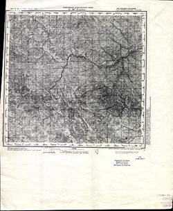
L-35-3 Селетин
N-35-138 Лунинец
N-35-102 Несьвеж
N-35-101 Барановичи
N-35-101 Барановичи
N-35-82 Березино
N-35-70 Борисов
N-35-68 Логойск
O-36-49-Б Батецкая
O-36-37-Б Торковичи
« Previous
Next »
1
2
3
4
5
…
9
10
Toggle facets
Limit your search
Type
Image
95
Creator
Stevens, Katherine (Mapmaker)
12
Geological Survey (U.S.)
5
Renshawe, John H.
3
McKinney, R. C. (Robert C.)
2
U.S. Lake Survey
2
Butler, Chas. T.
1
Cooke, Chas. E. (Charles E.)
1
Hawkins, Geo. T. (George T.)
1
Noble, Claude E.
1
Parke County (Ind.). Land Use Planning Committee
1
more
Creators
»
Subject
Topical Subject: Soviet Union
74
Topical Subject: Maps
73
Topical Subject: Landowners
15
Topical Subject: Real property
15
Geographic Subject: Baranovichi
2
Geographic Subject: Benton (Monroe County, Ind. : Township)
2
Geographic Subject: Lake County (Ind.)
2
Geographic Subject: Batetskaya
1
Geographic Subject: Bean Blossom (Monroe County, Ind. : Township)
1
Geographic Subject: Bloomington (Monroe County, Ind. : Township)
1
more
Subjects
»
Language
Russian
74
Publisher
Генеральный штаб РККА
44
Генеральный штаб Красной Армии
27
Stevens, Katherine (Mapmaker)
12
Geological Survey (U.S.)
5
Noble, Claude E.
1
Skinner, John, of Winslow, Indiana
1
United States. Bureau of Agricultural Economics
1
[Jennings County?]
1
Главное Управление Геодезии и Картографии при СНК СССР
1
Главное управление геодезии и картографии при СНК СССР
1
more
Publishers
»
Date Created
1939
[remove]
95
Pages
0-99 pages
95
Collections
Russian Military Topographic Map Collection
74
Indiana Historic Maps
21
State
deposited
95
Campus
IUB
95
City
Барановичи (Baranovichi)
2
Батецкая (Batetskaya)
1
Березино (Byerazino)
1
Борисов (Borisov)
1
Вайвара (Vaivara)
1
Васкелово (Vaskelovo)
1
Вирмутйоки (Virmutjoki)
1
Виру-Роэла (Viru-Roela)
1
Виру-Ягупи (Viru-Jaagupi)
1
Волди (Voldi)
1
Country
Финляндия (Finland)
44
СССР (USSR)
21
Эстония (Estonia)
12
Латвия (Latvia)
2
Румыния (Romania)
1
State/Province
РСФСР (RSFSR)
10
Белорусская ССР (Byelorussian Soviet Socialist Republic)
7
Ленинградская область (Leningrad oblast)
7
Аландские острова (Åland)
5
Минская область (Minsk oblast)
4
Барановичская область (Baranavichy oblast)
3
Карело-Финская ССР (Karelo-Finnish Soviet Socialist Republic)
3
Могилевская область (Mogilev oblast)
2
Украинская ССР (Ukrainian Soviet Socialist Republic)
2
Калининская область (Kalinin oblast)
1
Holding Location
B-WELLS
[remove]
95
Provenance
DMA Topographic Center, Army Map Service Library, OMAHA
44
Katherine Stevens. Township maps of Monroe County, Indiana, [1939]
12
Army Map Service Library, OMAHA, Library of Congress Geography & Map Division
9
DMA Topographic Center, Army Map Service Library, OMAHA, Library of Congress Geography & Map Division
6
DMA Topographic Center, Army Map Service Library
5
Part of Geological Survey (U.S.). Indiana 1:62,500.
5
DMA Topographic Center, Army Map Service Library, OMAHA, Auswärtiges Amt. Geographischer Dienst
4
Army Map Service Library, Library of Congress Geography & Map Division, OMAHA
1
CIA Map Branch -- Received, G000-30
1
CIA Map Library
1