
Search Constraints
You searched for:
Date Created
1941
Remove constraint Date Created: 1941
Publisher
Генеральный штаб Красной Армии
Remove constraint Publisher: Генеральный штаб Красной Армии
Search Results
-
- Subject:
- Topical Subject: Soviet Union, Geographic Subject: Kąkolewnica, and Topical Subject: Maps
- Publisher:
- Генеральный штаб Красной Армии
- Language:
- Russian
- Date Created:
- 1941
- Identifier:
- VAC9619-000153
- Genre:
- Topographic Maps and Military Maps
- Geographic Location:
- Coordinates: 51.8333, 22.5, 52, 22.75
- Related URL:
- Download GeoTIFF: https://drive.google.com/open?id=19CkkXHlE8nQuJ8AA3-Q69wmJr7QHjvmC and Catalog URL: http://iucat.iu.edu/catalog/5020131
- Abstract:
- Modern area represented: Kąkolewnica, Poland
- Call Number:
- G7000 s50 .S68 sheet M-34-10-A
- City:
- Конколевница (Kąkolewnica)
- Copyright Holder:
- No Copyright - United States
- Country:
- Область государственных интересов Германии (Region of German state interest)
- Physical Description:
- Scale: 1:50,000
- Persistent URL:
- http://purl.dlib.indiana.edu/iudl/images/VAC9619/VAC9619-000153
- Provenance:
- DMA Topographic Center, Army Map Service Library, OMAHA, Library of Congress Geography & Map Division
-
- Subject:
- Geographic Subject: Adamów, Topical Subject: Soviet Union, and Topical Subject: Maps
- Publisher:
- Генеральный штаб Красной Армии
- Language:
- Russian
- Date Created:
- 1941
- Identifier:
- VAC9619-000152
- Genre:
- Military Maps and Topographic Maps
- Geographic Location:
- Coordinates: 51.6667, 22.25, 51.8333, 22.5
- Related URL:
- Catalog URL: http://iucat.iu.edu/catalog/5020131 and Download GeoTIFF: https://drive.google.com/open?id=1A-V7YGDpgwqwkoOLI21eRM4SMuIlnrUM
- Abstract:
- Modern area represented: Adamów, Poland
- Call Number:
- G7000 s50 .S68 sheet M-34-9-D
- City:
- Адамув (Adamów)
- Copyright Holder:
- No Copyright - United States
- Country:
- Область государственных интересов Германии (Region of German state interest)
- Physical Description:
- Scale: 1:50,000
- Persistent URL:
- http://purl.dlib.indiana.edu/iudl/images/VAC9619/VAC9619-000152
- Provenance:
- Library of Congress Geography & Map Division
-
- Subject:
- Topical Subject: Maps, Geographic Subject: Okrzeja, and Topical Subject: Soviet Union
- Publisher:
- Генеральный штаб Красной Армии
- Language:
- Russian
- Date Created:
- 1941
- Identifier:
- VAC9619-000151
- Genre:
- Topographic Maps and Military Maps
- Geographic Location:
- Coordinates: 51.6667, 22, 51.8333, 22.25
- Related URL:
- Catalog URL: http://iucat.iu.edu/catalog/5020131 and Download GeoTIFF: https://drive.google.com/open?id=1V9nAHHjmqyYmIwZvQR3lZZfnsP3KbSWZ
- Abstract:
- Modern area represented: Okrzeja, Poland
- Call Number:
- G7000 s50 .S68 sheet M-34-9-C
- City:
- Окшея (Okrzeja)
- Copyright Holder:
- No Copyright - United States
- Country:
- Область государственных интересов Германии (Region of German state interest)
- Physical Description:
- Scale: 1:50,000
- Persistent URL:
- http://purl.dlib.indiana.edu/iudl/images/VAC9619/VAC9619-000151
- Provenance:
- DMA Topographic Center, Army Map Service Library, OMAHA, Library of Congress Geography & Map Division
-
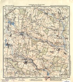
- Subject:
- Topical Subject: Maps, Geographic Subject: Łuków, and Topical Subject: Soviet Union
- Publisher:
- Генеральный штаб Красной Армии
- Language:
- Russian
- Date Created:
- 1941
- Identifier:
- VAC9619-000150
- Genre:
- Topographic Maps and Military Maps
- Geographic Location:
- Coordinates: 51.8333, 22.25, 52, 22.5
- Related URL:
- Catalog URL: http://iucat.iu.edu/catalog/5020131 and Download GeoTIFF: https://drive.google.com/open?id=1sVY22nb7fS4CKXtxkjdjvtQnaxd4cO87
- Abstract:
- Modern area represented: Łuków, Poland
- Call Number:
- G7000 s50 .S68 sheet M-34-9-B
- City:
- Луков (Łuków)
- Copyright Holder:
- No Copyright - United States
- Country:
- Область государственных интересов Германии (Region of German state interest)
- Physical Description:
- Scale: 1:50,000
- Persistent URL:
- http://purl.dlib.indiana.edu/iudl/images/VAC9619/VAC9619-000150
- Provenance:
- DMA Topographic Center, Army Map Service Library, OMAHA, Library of Congress Geography & Map Division
-
- Subject:
- Topical Subject: Soviet Union, Topical Subject: Maps, and Geographic Subject: Nowy Dwór Mazowiecki
- Publisher:
- Генеральный штаб Красной Армии
- Language:
- Russian
- Date Created:
- 1941
- Identifier:
- VAC9619-000146
- Genre:
- Military Maps and Topographic Maps
- Geographic Location:
- Coordinates: 52.3333, 20.5, 52.5, 20.6667
- Related URL:
- Download GeoTIFF: https://drive.google.com/open?id=1jjJwHRaXBPCIZUG-msLmfYa5McZJk4Zs and Catalog URL: http://iucat.iu.edu/catalog/5020131
- Abstract:
- Modern area represented: Nowy Dwór Mazowiecki, Poland
- Call Number:
- G7000 s50 .S68 sheet N-34-126-C
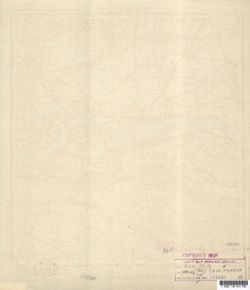
- Caption:
- Captured map
- City:
- Модлин (Modlin)
- Copyright Holder:
- No Copyright - United States
- Country:
- Область государственных интересов Германии (Region of German state interest)
- Physical Description:
- Scale: 1:50,000
- Persistent URL:
- http://purl.dlib.indiana.edu/iudl/images/VAC9619/VAC9619-000146
- Provenance:
- Army Map Service Library, OMAHA, Library of Congress Geography & Map Division
-
- Subject:
- Topical Subject: Maps, Geographic Subject: Magnuszew, and Topical Subject: Soviet Union
- Publisher:
- Генеральный штаб Красной Армии
- Language:
- Russian
- Date Created:
- 1941
- Identifier:
- VAC9619-000147
- Genre:
- Military Maps and Topographic Maps
- Geographic Location:
- Coordinates: 51.6667, 21.25, 51.8333, 21.5
- Related URL:
- Download GeoTIFF: https://drive.google.com/open?id=1Cte1Ddv4E2azkPg6vpqzVtkhMnlK4-Gw and Catalog URL: http://iucat.iu.edu/catalog/5020131
- Abstract:
- Modern area represented: Magnuszew, Poland
- Call Number:
- G7000 s50 .S68 sheet M-34-7-D
- City:
- Магнушев (Magnuszew)
- Copyright Holder:
- No Copyright - United States
- Country:
- Область государственных интересов Германии (Region of German state interest)
- Physical Description:
- Scale: 1:50,000
- Persistent URL:
- http://purl.dlib.indiana.edu/iudl/images/VAC9619/VAC9619-000147
- Provenance:
- DMA Topographic Center, Army Map Service Library, OMAHA, Library of Congress Geography & Map Division
-
- Subject:
- Geographic Subject: Stanin, Topical Subject: Soviet Union, and Topical Subject: Maps
- Publisher:
- Генеральный штаб Красной Армии
- Language:
- Russian
- Date Created:
- 1941
- Identifier:
- VAC9619-000149
- Genre:
- Military Maps and Topographic Maps
- Geographic Location:
- Coordinates: 51.8333, 22, 52, 22.25
- Related URL:
- Download GeoTIFF: https://drive.google.com/open?id=1KwDIG_y5qJ1ZdhiXD-EPvC2uUltKuYZ5 and Catalog URL: http://iucat.iu.edu/catalog/5020131
- Abstract:
- Modern area represented: Stanin, Poland
- Call Number:
- G7000 s50 .S68 sheet M-34-9-A
- City:
- Станин (Stanin)
- Copyright Holder:
- No Copyright - United States
- Country:
- Область государственных интересов Германии (Region of German state interest)
- Physical Description:
- Scale: 1:50,000
- Persistent URL:
- http://purl.dlib.indiana.edu/iudl/images/VAC9619/VAC9619-000149
- Provenance:
- DMA Topographic Center, Army Map Service Library, OMAHA, Library of Congress Geography & Map Division
-
- Subject:
- Topical Subject: Maps, Topical Subject: Soviet Union, and Geographic Subject: Żelechów
- Publisher:
- Генеральный штаб Красной Армии
- Language:
- Russian
- Date Created:
- 1941
- Identifier:
- VAC9619-000148
- Genre:
- Topographic Maps and Military Maps
- Geographic Location:
- Coordinates: 51.6667, 21.75, 51.8333, 22
- Related URL:
- Download GeoTIFF: https://drive.google.com/open?id=1vF61DI2wuJiPyW85jY0RMnb1dubq2gjD and Catalog URL: http://iucat.iu.edu/catalog/5020131
- Abstract:
- Modern area represented: Żelechów, Poland
- Call Number:
- G7000 s50 .S68 sheet M-34-8-D
- City:
- Желехув (Żelechów)
- Copyright Holder:
- No Copyright - United States
- Country:
- Область государственных интересов Германии (Region of German state interest)
- Physical Description:
- Scale: 1:50,000
- Persistent URL:
- http://purl.dlib.indiana.edu/iudl/images/VAC9619/VAC9619-000148
- Provenance:
- DMA Topographic Center, Army Map Service Library, OMAHA, Library of Congress Geography & Map Division
-
- Description:
- 1939
- Subject:
- Topical Subject: Soviet Union, Geographic Subject: Otradnoye, and Topical Subject: Maps
- Publisher:
- Генеральный штаб Красной Армии
- Language:
- Russian
- Date Created:
- 1941
- Identifier:
- VAC9619-000006
- Genre:
- Military Maps and Topographic Maps
- Geographic Location:
- Coordinates: 59.6667, 30.75, 59.8333, 31
- Related URL:
- Catalog URL: http://iucat.iu.edu/catalog/5020131 and Download GeoTIFF: https://drive.google.com/open?id=13COc5AgGZxXZZGDEvwCTHdGopCfnaIpJ
- Abstract:
- Modern area represented: Otradnoye, Russia
- Call Number:
- G7000 s50 .S68 sheet O-36-2-D
- Caption:
- Секретно
- City:
- Отрадное (Otradnoye)
- Copyright Holder:
- No Copyright - United States
- Country:
- СССР (USSR)
- State/Province:
- Ленинградская область (Leningrad oblast) and РСФСР (RSFSR)
- Physical Description:
- Scale: 1:50,000
- Persistent URL:
- http://purl.dlib.indiana.edu/iudl/images/VAC9619/VAC9619-000006
- Provenance:
- DMA Topographic Center, Army Map Service Library, OMAHA, Library of Congress Geography & Map Division
-
- Description:
- 1939
- Subject:
- Topical Subject: Maps, Geographic Subject: Kolpino, and Topical Subject: Soviet Union
- Publisher:
- Генеральный штаб Красной Армии
- Language:
- Russian
- Date Created:
- 1941
- Identifier:
- VAC9619-000005
- Genre:
- Topographic Maps and Military Maps
- Geographic Location:
- Coordinates: 59.6667, 30.5, 59.8333, 30.75
- Related URL:
- Download GeoTIFF: https://drive.google.com/open?id=1kGu3hZQppIl96eGP8w6F_llnnTJlbJhM and Catalog URL: http://iucat.iu.edu/catalog/5020131
- Abstract:
- Modern area represented: Kolpino, Russia
- Call Number:
- G7000 s50 .S68 sheet O-36-2-C
- Caption:
- Секретно,Captured map
- City:
- Колпино (Kolpino)
- Copyright Holder:
- No Copyright - United States
- Country:
- СССР (USSR)
- State/Province:
- РСФСР (RSFSR) and Ленинградская область (Leningrad oblast)
- Physical Description:
- Scale: 1:50,000
- Persistent URL:
- http://purl.dlib.indiana.edu/iudl/images/VAC9619/VAC9619-000005
- Provenance:
- Army Map Service Library, OMAHA, Library of Congress Geography & Map Division
