
Search Constraints
You searched for:
Date Created
1940
Remove constraint Date Created: 1940
Language
Russian
Remove constraint Language: Russian
State/Province
Вилейская область (Vileyka oblast)
Remove constraint State/Province: Вилейская область (Vileyka oblast)
1 - 5 of 5
Search Results
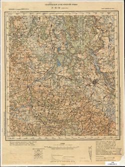
-
- Description:
- 1899
- Subject:
- Geographic Subject: Yuratsishki, Topical Subject: Soviet Union, and Topical Subject: Maps
- Publisher:
- Генеральный штаб Красной Армии
- Language:
- Russian
- Date Created:
- 1940
- Identifier:
- VAC9619-004065
- Genre:
- Topographic Maps and Military Maps
- Geographic Location:
- Coordinates: 54, 25.5, 54.333, 26
- Related URL:
- Download GeoTIFF: https://drive.google.com/file/d/1S208tYzBNgJlOJ0Z-RWb-phjImadfveI/view?usp=sharing and Catalog URL: https://iucat.iu.edu/catalog/5020129
- Abstract:
- Modern area represented: Yuratsishki, Hrodna oblast, Belarus
- Call Number:
- G7000 s100 .S7 sheet N-35-64
- Caption:
- Для служебного пользования
- City:
- Юратишки (Yuratsishki)
- Copyright Holder:
- No Copyright - United States
- Country:
- СССР (USSR)
- State/Province:
- Барановичская область (Baranavichy oblast), Вилейская область (Vileyka oblast), and Белорусская ССР (Byelorussian Soviet Socialist Republic)
- Physical Description:
- Scale: 1:100,000
- Persistent URL:
- http://purl.dlib.indiana.edu/iudl/images/VAC9619/VAC9619-004065
- Provenance:
- DMA Topographic Center, Army Map Service Library
-
- Description:
- 1904
- Subject:
- Geographic Subject: Vileyka, Topical Subject: Soviet Union, and Topical Subject: Maps
- Publisher:
- Генеральный штаб Красной Армии
- Language:
- Russian
- Date Created:
- 1940
- Identifier:
- VAC9619-004056
- Genre:
- Military Maps and Topographic Maps
- Geographic Location:
- Coordinates: 54.333, 26.5, 54.667, 27
- Related URL:
- Download GeoTIFF: https://drive.google.com/file/d/1kyEkVOJvt8AXa5spmn7Jfn3fOLgVscJy/view?usp=sharing and Catalog URL: https://iucat.iu.edu/catalog/5020129
- Abstract:
- Modern area represented: Vileyka, Belarus
- Call Number:
- G7000 s100 .S7 sheet N-35-54
- City:
- Вилейка (Vileyka)
- Copyright Holder:
- No Copyright - United States
- Country:
- СССР (USSR)
- State/Province:
- Вилейская область (Vileyka oblast) and Белорусская ССР (Byelorussian Soviet Socialist Republic)
- Physical Description:
- Scale: 1:100,000
- Persistent URL:
- http://purl.dlib.indiana.edu/iudl/images/VAC9619/VAC9619-004056
- Provenance:
- DMA Topographic Center, Army Map Service Library
-
- Description:
- 1903
- Subject:
- Geographic Subject: Smarhon, Topical Subject: Maps, and Topical Subject: Soviet Union
- Publisher:
- Генеральный штаб Красной Армии
- Language:
- Russian
- Date Created:
- 1940
- Identifier:
- VAC9619-004055
- Genre:
- Topographic Maps and Military Maps
- Geographic Location:
- Coordinates: 54.333, 26, 54.667, 26.5
- Related URL:
- Download GeoTIFF: https://drive.google.com/file/d/1Hyh1FTHPh2WfcSA6rFTZ67hecvz2-9cA/view?usp=sharing and Catalog URL: https://iucat.iu.edu/catalog/5020129
- Abstract:
- Modern area represented: Smarhon, Hrodna oblast, Belarus
- Call Number:
- G7000 s100 .S7 sheet N-35-53
- City:
- Сморгонь (Smarhon)
- Copyright Holder:
- No Copyright - United States
- Country:
- СССР (USSR)
- State/Province:
- Белорусская ССР (Byelorussian Soviet Socialist Republic) and Вилейская область (Vileyka oblast)
- Physical Description:
- Scale: 1:100,000
- Persistent URL:
- http://purl.dlib.indiana.edu/iudl/images/VAC9619/VAC9619-004055
- Provenance:
- DMA Topographic Center, Army Map Service Library
-
- Description:
- 1902
- Subject:
- Topical Subject: Maps, Topical Subject: Soviet Union, and Geographic Subject: Kanstantsinava
- Publisher:
- Генеральный штаб Красной Армии
- Language:
- Russian
- Date Created:
- 1940
- Identifier:
- VAC9619-004043
- Genre:
- Military Maps and Topographic Maps
- Geographic Location:
- Coordinates: 54.667, 26, 55, 26.5
- Related URL:
- Download GeoTIFF: https://drive.google.com/file/d/1fERWEWK0tAjQ0A3TwarxKhNxb2zUh5xs/view?usp=sharing and Catalog URL: https://iucat.iu.edu/catalog/5020129
- Abstract:
- Modern area represented: Kanstantsinava, Belarus
- Call Number:
- G7000 s100 .S7 sheet N-35-41
- Caption:
- Для служебного пользования
- City:
- Константинов (Konstantinov)
- Copyright Holder:
- No Copyright - United States
- Country:
- СССР (USSR)
- State/Province:
- Литовская ССР (Lithuanian Soviet Socialist Republic), Вилейская область (Vileyka oblast), and Белорусская ССР (Byelorussian Soviet Socialist Republic)
- Physical Description:
- Scale: 1:100,000
- Persistent URL:
- http://purl.dlib.indiana.edu/iudl/images/VAC9619/VAC9619-004043
- Provenance:
- DMA Topographic Center, Army Map Service Library
-
- Description:
- 1896
- Subject:
- Topical Subject: Soviet Union, Geographic Subject: Pabradė, and Topical Subject: Maps
- Publisher:
- Генеральный штаб Красной Армии
- Language:
- Russian
- Date Created:
- 1940
- Identifier:
- VAC9619-004042
- Genre:
- Military Maps and Topographic Maps
- Geographic Location:
- Coordinates: 54.667, 25.5, 55, 26
- Related URL:
- Catalog URL: https://iucat.iu.edu/catalog/5020129 and Download GeoTIFF: https://drive.google.com/file/d/1YFsfTU9po10RXE5Yt1qzruLaxNk6ivoW/view?usp=sharing
- Abstract:
- Modern area represented: Pabradė, Lithuania
- Call Number:
- G7000 s100 .S7 sheet N-35-40
- Caption:
- Для служебного пользования
- City:
- Подбродзе (Podbrodze)
- Copyright Holder:
- No Copyright - United States
- Country:
- СССР (USSR)
- State/Province:
- Белорусская ССР (Byelorussian Soviet Socialist Republic), Литовская ССР (Lithuanian Soviet Socialist Republic), and Вилейская область (Vileyka oblast)
- Physical Description:
- Scale: 1:100,000
- Persistent URL:
- http://purl.dlib.indiana.edu/iudl/images/VAC9619/VAC9619-004042
- Provenance:
- DMA Topographic Center, Army Map Service Library
