
Search Constraints
You searched for:
Country
Польша (Poland)
Remove constraint Country: Польша (Poland)
Country
СССР (USSR)
Remove constraint Country: СССР (USSR)
Provenance
DMA Topographic Center, Army Map Service Library, OMAHA, Library of Congress Geography & Map Division
Remove constraint Provenance: DMA Topographic Center, Army Map Service Library, OMAHA, Library of Congress Geography & Map Division
1 - 8 of 8
Search Results
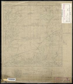
-
- Description:
- 1909
- Subject:
- Topical Subject: Soviet Union, Geographic Subject: Rokytne, and Topical Subject: Maps
- Publisher:
- Генеральный штаб РККА
- Language:
- Russian
- Date Created:
- 1910
- Identifier:
- VAC9619-003110
- Genre:
- Topographic Maps and Military Maps
- Geographic Location:
- Coordinates: 51, 27, 51.333, 27.5
- Related URL:
- Download GeoTIFF: https://drive.google.com/file/d/15D76DyRFPEKsC74NMx-YBm89YPBAbzlF/view?usp=sharing and Catalog URL: https://iucat.iu.edu/catalog/5020129
- Abstract:
- Modern area represented: Rokytne, Rivne oblast, Ukraine
- Call Number:
- G7000 s100 .S7 sheet M-35-31
- Caption:
- Не подлежит оглашению
- City:
- Рокитно (Rokytne)
- Copyright Holder:
- No Copyright - United States
- Country:
- Польша (Poland) and СССР (USSR)
- State/Province:
- Украинская ССР (Ukrainian Soviet Socialist Republic) and Житомирская область (Zhytomyr oblast)
- Physical Description:
- Scale: 1:100,000
- Persistent URL:
- http://purl.dlib.indiana.edu/iudl/images/VAC9619/VAC9619-003110
- Provenance:
- DMA Topographic Center, Army Map Service Library, OMAHA, Library of Congress Geography & Map Division
-
- Description:
- 1931
- Subject:
- Geographic Subject: Lyudzyanyevichy, Topical Subject: Soviet Union, and Topical Subject: Maps
- Publisher:
- Управление военных топографов
- Language:
- Russian
- Identifier:
- VAC9619-000805
- Genre:
- Military Maps and Topographic Maps
- Geographic Location:
- Coordinates: 52.167, 27.5, 52.333, 27.75
- Related URL:
- Download GeoTIFF: https://drive.google.com/open?id=1Iz6igjqfubylUvJDRkPnaNLvnw66JNjs and Catalog URL: http://iucat.iu.edu/catalog/5020131
- Abstract:
- Modern area represented: Lyudzyanyevichy, Homyel oblast, Belarus
- Call Number:
- G7000 s50 .s68 sheet N-35-140-A
- Caption:
- Не подлежит оглашению
- City:
- Люденевичи (Lyudenevichi)
- Copyright Holder:
- No Copyright - United States
- Country:
- Польша (Poland) and СССР (USSR)
- State/Province:
- Белорусская ССР (Byelorussian Soviet Socialist Republic)
- Physical Description:
- Scale: 1:50,000
- Persistent URL:
- http://purl.dlib.indiana.edu/iudl/images/VAC9619/VAC9619-000805
- Provenance:
- DMA Topographic Center, Army Map Service Library, OMAHA, Library of Congress Geography & Map Division
-

- Subject:
- Geographic Subject: Mikashevichy, Topical Subject: Soviet Union, and Topical Subject: Maps
- Publisher:
- Генеральный штаб РККА
- Language:
- Russian
- Identifier:
- VAC9619-000802
- Genre:
- Military Maps and Topographic Maps
- Geographic Location:
- Coordinates: 52.167, 27.25, 52.333, 27.5
- Related URL:
- Catalog URL: http://iucat.iu.edu/catalog/5020131 and Download GeoTIFF: https://drive.google.com/open?id=158CB0vm9B2tc2bHOMOQdft1MDwUmRNDH
- Abstract:
- Modern area represented: Mikashevichy, Brest oblast, Belarus
- Call Number:
- G7000 s50 .s68 sheet N-35-139-B
- Caption:
- Не подлежит оглашению
- City:
- Микашевиче (Mikaszewicze)
- Copyright Holder:
- No Copyright - United States
- Country:
- СССР (USSR) and Польша (Poland)
- State/Province:
- Полесская область (Polesia oblast) and Белорусская ССР (Byelorussian Soviet Socialist Republic)
- Physical Description:
- Scale: 1:50,000
- Persistent URL:
- http://purl.dlib.indiana.edu/iudl/images/VAC9619/VAC9619-000802
- Provenance:
- DMA Topographic Center, Army Map Service Library, OMAHA, Library of Congress Geography & Map Division
-
- Subject:
- Topical Subject: Soviet Union, Geographic Subject: Магільна (Mahil’na), and Topical Subject: Maps
- Publisher:
- Генеральный штаб РККА
- Language:
- Russian
- Identifier:
- VAC9619-000643
- Genre:
- Military Maps and Topographic Maps
- Geographic Location:
- Coordinates: 53.333, 26.75, 53.5, 27
- Related URL:
- Download GeoTIFF: https://drive.google.com/open?id=11-YaO33WFuytxASEWZ2JSRVvJvpTVnvK and Catalog URL: http://iucat.iu.edu/catalog/5020131
- Abstract:
- Modern area represented: Магільна (Mahil’na), Minsk Oblast, Belarus
- Call Number:
- G7000 s50 .S68 sheet N-35-90-D
- Caption:
- Не подлежит оглашению and Captured map
- City:
- Могильно (Mogil'no)
- Copyright Holder:
- No Copyright - United States
- Country:
- Польша (Poland) and СССР (USSR)
- State/Province:
- Белорусская ССР (Byelorussian Soviet Socialist Republic)
- Physical Description:
- Scale: 1:50,000
- Persistent URL:
- http://purl.dlib.indiana.edu/iudl/images/VAC9619/VAC9619-000643
- Provenance:
- DMA Topographic Center, Army Map Service Library, OMAHA, Library of Congress Geography & Map Division
-
- Subject:
- Geographic Subject: Slabada (Slabada), Topical Subject: Soviet Union, and Topical Subject: Maps
- Publisher:
- Управление военных топографов РККА
- Language:
- Russian
- Identifier:
- VAC9619-000641
- Genre:
- Military Maps and Topographic Maps
- Geographic Location:
- Coordinates: 53.5, 26.75, 53.667, 27
- Related URL:
- Download GeoTIFF: https://drive.google.com/open?id=1yvhxZ36MOk-sOh0q-bYrOEGycfvIlTsl and Catalog URL: http://iucat.iu.edu/catalog/5020131
- Abstract:
- Modern area represented: Slabada (Slabada), Minsk Oblast, Belarus
- Call Number:
- G7000 s50 .S68 sheet N-35-90-B
- Caption:
- Не подлежит оглашению
- City:
- Слобода (Sloboda)
- Copyright Holder:
- No Copyright - United States
- Country:
- СССР (USSR) and Польша (Poland)
- State/Province:
- Белорусская ССР (Byelorussian Soviet Socialist Republic)
- Physical Description:
- Scale: 1:50,000
- Persistent URL:
- http://purl.dlib.indiana.edu/iudl/images/VAC9619/VAC9619-000641
- Provenance:
- DMA Topographic Center, Army Map Service Library, OMAHA, Library of Congress Geography & Map Division
-
- Subject:
- Geographic Subject: Kylykyiv, Topical Subject: Soviet Union, and Topical Subject: Maps
- Publisher:
- Управление военных топографов РККА
- Language:
- Russian
- Date Created:
- 1932
- Identifier:
- VAC9619-000222
- Genre:
- Topographic Maps and Military Maps
- Geographic Location:
- Coordinates: 50.5, 27, 50.667, 27.25
- Related URL:
- Download GeoTIFF: https://drive.google.com/open?id=1Y9wUaxz3y48-qxkJlwKX7xLRzY0AHUBF and Catalog URL: http://iucat.iu.edu/catalog/5020131
- Abstract:
- Modern area represented: Kylykyiv, Khmelnytskyi oblast, Ukraine
- Call Number:
- G7000 s50 .S68 sheet M-35-55-A
- Caption:
- Не подлежит оглашению
- City:
- Киликиев (Kilikiyev)
- Copyright Holder:
- No Copyright - United States
- Country:
- СССР (USSR) and Польша (Poland)
- State/Province:
- Киевская область (Kyiv oblast) and Украинская ССР (Ukrainian Soviet Socialist Republic)
- Physical Description:
- Scale: 1:50,000
- Persistent URL:
- http://purl.dlib.indiana.edu/iudl/images/VAC9619/VAC9619-000222
- Provenance:
- DMA Topographic Center, Army Map Service Library, OMAHA, Library of Congress Geography & Map Division
-
- Subject:
- Topical Subject: Maps, Topical Subject: Soviet Union, and Geographic Subject: Staryi Kryvyn
- Publisher:
- Управление военных топографов РККА
- Language:
- Russian
- Identifier:
- VAC9619-000221
- Genre:
- Military Maps and Topographic Maps
- Geographic Location:
- Coordinates: 50.333, 26.5, 50.5, 26.75
- Related URL:
- Download GeoTIFF: https://drive.google.com/open?id=1NeVgdKaOZrGWcahMxFINq_u0xqb86lzF and Catalog URL: http://iucat.iu.edu/catalog/5020131
- Abstract:
- Modern area represented: Staryi Kryvyn, Khmelnytskyi oblast, Ukraine
- Call Number:
- G7000 s50 .S68 sheet M-35-54-C
- Caption:
- Не подлежит оглашению
- City:
- Кривин (Krivin)
- Copyright Holder:
- No Copyright - United States
- Country:
- Польша (Poland) and СССР (USSR)
- State/Province:
- Украинская ССР (Ukrainian Soviet Socialist Republic) and Винницкая область (Vinnytsia oblast)
- Physical Description:
- Scale: 1:50,000
- Persistent URL:
- http://purl.dlib.indiana.edu/iudl/images/VAC9619/VAC9619-000221
- Provenance:
- DMA Topographic Center, Army Map Service Library, OMAHA, Library of Congress Geography & Map Division
-
- Subject:
- Geographic Subject: Radymno, Topical Subject: Maps, and Topical Subject: Soviet Union
- Publisher:
- Генеральный штаб Красной Армии
- Language:
- Russian
- Date Created:
- 1943
- Identifier:
- VAC9619-000186
- Genre:
- Topographic Maps and Military Maps
- Geographic Location:
- Coordinates: 49.8333, 22.75, 50, 23
- Related URL:
- Download GeoTIFF: https://drive.google.com/open?id=1pqBU3q09-3jEad3cJnm_hpV3oPYNXXhm and Catalog URL: http://iucat.iu.edu/catalog/5020131
- Abstract:
- Modern area represented: Radymno, Poland
- Call Number:
- G7000 s50 .S68 sheet M-34-82-B
- Caption:
- Для служебного пользования
- City:
- Радымно (Radymno)
- Copyright Holder:
- No Copyright - United States
- Country:
- СССР (USSR) and Польша (Poland)
- State/Province:
- Украинская ССР (Ukrainian Soviet Socialist Republic), Дрогобычская область (Drohobych oblast), and Львовская область (Lviv oblast)
- Physical Description:
- Scale: 1:50,000
- Persistent URL:
- http://purl.dlib.indiana.edu/iudl/images/VAC9619/VAC9619-000186
- Provenance:
- DMA Topographic Center, Army Map Service Library, OMAHA, Library of Congress Geography & Map Division
