
Search Constraints
You searched for:
Provenance
CIA Map Library
Remove constraint Provenance: CIA Map Library
« Previous |
1 - 50 of 172
|
Next »
Search Results
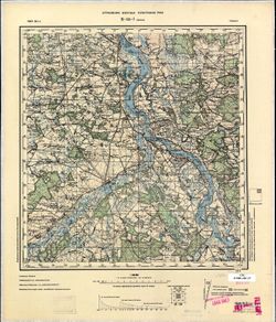
-
- Description:
- 1922
- Subject:
- Topical Subject: Soviet Union, Topical Subject: Maps, and Geographic Subject: Mytishchi
- Publisher:
- Управление военных топографов
- Language:
- Russian
- Date Created:
- 1929
- Identifier:
- VAC9619-001586
- Genre:
- Military Maps and Topographic Maps
- Geographic Location:
- Coordinates: 55.8667, 37.75, 56, 38
- Related URL:
- Catalog URL: http://iucat.iu.edu/catalog/5020131 and Download GeoTIFF: https://drive.google.com/open?id=1PxyJ7XDtUzjmwpjIlxN45-6k_XMUG50I
- Abstract:
- Modern area represented: Mytishchi, Moscow oblast, Russia
- Call Number:
- G7000 s50 .S68 sheet N-37-4-B
- City:
- Мытищи (Mytishchi)
- Copyright Holder:
- No Copyright - United States
- Country:
- СССР (USSR)
- State/Province:
- РСФСР (RSFSR) and Московская область (Moscow oblast)
- Physical Description:
- Scale: 1:50,000
- Persistent URL:
- http://purl.dlib.indiana.edu/iudl/images/VAC9619/VAC9619-001586
- Provenance:
- CIA Map Library
-
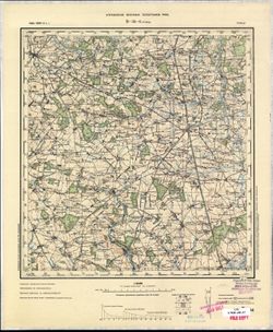
- Description:
- 1888
- Subject:
- Topical Subject: Maps, Geographic Subject: Roman, and Topical Subject: Soviet Union
- Publisher:
- Генеральный штаб РККА
- Language:
- Russian
- Date Created:
- 1940
- Identifier:
- VAC9619-001540
- Genre:
- Military Maps and Topographic Maps
- Geographic Location:
- Coordinates: 46.6667, 26.5, 47, 27
- Related URL:
- Download GeoTIFF: https://drive.google.com/open?id=1i2pvbe1wRYaxyTOVF2cgHePtUEz_ZnoF and Catalog URL: https://iucat.iu.edu/catalog/5020129
- Abstract:
- Modern area represented: Roman, Neamţ county, Romania
- Call Number:
- G7000 s100 .S7 sheet L-35-42
- City:
- Роман (Roman)
- Copyright Holder:
- No Copyright - United States
- Country:
- Румыния (Romania)
- Physical Description:
- Scale: 1:100,000
- Persistent URL:
- http://purl.dlib.indiana.edu/iudl/images/VAC9619/VAC9619-001540
- Provenance:
- CIA Map Library
-
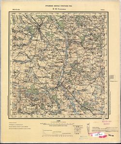
- Description:
- 1873
- Subject:
- Topical Subject: Soviet Union, Topical Subject: Maps, and Geographic Subject: Călărasi-Targ
- Publisher:
- Генеральный штаб РККА
- Language:
- Russian
- Date Created:
- 1940
- Identifier:
- VAC9619-001529
- Genre:
- Topographic Maps and Military Maps
- Geographic Location:
- Coordinates: 47, 28, 47.3333, 28.5
- Related URL:
- Download GeoTIFF: https://drive.google.com/open?id=1tChuAu9yqWs5ys8Z7tNhOEmgq69Apb3I and Catalog URL: https://iucat.iu.edu/catalog/5020129
- Abstract:
- Modern area represented: Călărasi-Targ, Călăraşi county, Moldova
- Call Number:
- G7000 s100 .S7 sheet L-35-33
- City:
- Калараш-Тырг (Călărasi-Targ)
- Copyright Holder:
- No Copyright - United States
- Country:
- Румыния (Romania)
- State/Province:
- Бессарабия (Bessarabia)
- Physical Description:
- Scale: 1:100,000
- Persistent URL:
- http://purl.dlib.indiana.edu/iudl/images/VAC9619/VAC9619-001529
- Provenance:
- CIA Map Library
-
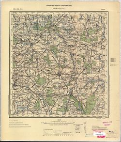
- Description:
- 1873
- Subject:
- Topical Subject: Maps, Topical Subject: Soviet Union, and Geographic Subject: Slobidka
- Publisher:
- Генеральный штаб РККА
- Language:
- Russian
- Date Created:
- 1933
- Identifier:
- VAC9619-001502
- Genre:
- Military Maps and Topographic Maps
- Geographic Location:
- Coordinates: 47.6667, 29, 48, 29.5
- Related URL:
- Download GeoTIFF: https://drive.google.com/open?id=12hPOl2XNIpsYO7n4_yTuCA5VYkAUpSEV and Catalog URL: https://iucat.iu.edu/catalog/5020129
- Abstract:
- Modern area represented: Slobidka, Odessa oblast, Ukraine
- Call Number:
- G7000 s100 .S7 sheet L-35-11
- Caption:
- Не подлежит оглашению
- City:
- Пос. Слободка (Slobodka village)
- Copyright Holder:
- No Copyright - United States
- State/Province:
- Украинская ССР (Ukrainian Soviet Socialist Republic), Бессарабия (Bessarabia), and Молдавская АССР (Moldavian Autonomous Soviet Socialist Republic)
- Physical Description:
- Scale: 1:100,000
- Persistent URL:
- http://purl.dlib.indiana.edu/iudl/images/VAC9619/VAC9619-001502
- Provenance:
- CIA Map Library
-
- Subject:
- Topical Subject: Maps, Topical Subject: Soviet Union, and Geographic Subject: Dorohoi
- Language:
- Russian
- Identifier:
- VAC9619-001484
- Genre:
- Military Maps and Topographic Maps
- Geographic Location:
- Coordinates: 47.6667, 26, 48, 26.5
- Related URL:
- Download GeoTIFF: https://drive.google.com/open?id=1_okPkJQP2ytUi_A9hy_wDuSNNnN_6zmt and Catalog URL: https://iucat.iu.edu/catalog/5020129
- Abstract:
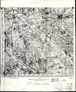
- Modern area represented: Dorohoi, Botoşani county, Romania
- Call Number:
- G7000 s100 .S7 sheet L-35-5
- Copyright Holder:
- No Copyright - United States
- Physical Description:
- Scale: 1:100,000
- Persistent URL:
- http://purl.dlib.indiana.edu/iudl/images/VAC9619/VAC9619-001484
- Provenance:
- CIA Map Library
-
- Description:
- 1894
- Subject:
- Geographic Subject: Radauti, Topical Subject: Maps, and Topical Subject: Soviet Union
- Publisher:
- Управление военных топографов
- Language:
- Russian
- Date Created:
- 1896
- Identifier:
- VAC9619-001476
- Genre:
- Military Maps and Topographic Maps
- Geographic Location:
- Coordinates: 47.6667, 25.5, 48, 26
- Related URL:
- Catalog URL: https://iucat.iu.edu/catalog/5020129 and Download GeoTIFF: https://drive.google.com/open?id=1Fs-EOKsTjzwn8kRjdd33KxXLufCNUkix
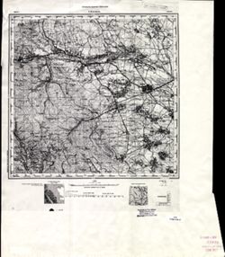
- Abstract:
- Modern area represented: Radauti, Suceava county, Romania
- Call Number:
- G7000 s100 .S7 sheet L-35-4
- Caption:
- Для служебного пользования
- City:
- Рэдэуци (Radauti)
- Copyright Holder:
- No Copyright - United States
- Country:
- Румыния (Romania)
- Physical Description:
- Scale: 1:100,000
- Persistent URL:
- http://purl.dlib.indiana.edu/iudl/images/VAC9619/VAC9619-001476
- Provenance:
- CIA Map Library
-
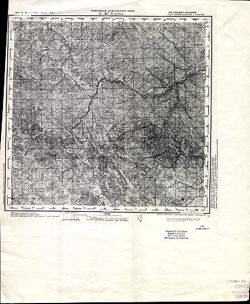
- Description:
- 1873
- Subject:
- Geographic Subject: Selyatyn, Topical Subject: Maps, and Topical Subject: Soviet Union
- Publisher:
- Генеральный штаб Красной Армии
- Language:
- Russian
- Date Created:
- 1939
- Identifier:
- VAC9619-001472
- Genre:
- Military Maps and Topographic Maps
- Geographic Location:
- Coordinates: 47.6667, 25, 48, 25.5
- Related URL:
- Download GeoTIFF: https://drive.google.com/open?id=1v6zIUxpzw2mb5AD7jE4-hVpFfWBpe8B8 and Catalog URL: https://iucat.iu.edu/catalog/5020129
- Abstract:
- Modern area represented: Selyatyn, Chernivtsi oblast, Ukraine
- Call Number:
- G7000 s100 .S7 sheet L-35-3
- Caption:
- Для служебного пользования
- City:
- Селетин (Selyatyn)
- Copyright Holder:
- No Copyright - United States
- Country:
- Румыния (Romania)
- State/Province:
- Украинская ССР (Ukrainian Soviet Socialist Republic) and Черновицкая область (Chernivtsi oblast)
- Physical Description:
- Scale: 1:100,000
- Persistent URL:
- http://purl.dlib.indiana.edu/iudl/images/VAC9619/VAC9619-001472
- Provenance:
- CIA Map Library
-
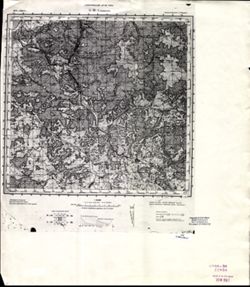
- Description:
- 1874
- Subject:
- Topical Subject: Maps, Topical Subject: Soviet Union, and Geographic Subject: Velykyy Bychkiv
- Publisher:
- Генеральный штаб РККА
- Language:
- Russian
- Date Created:
- 1930
- Identifier:
- VAC9619-001463
- Genre:
- Topographic Maps and Military Maps
- Geographic Location:
- Coordinates: 47.6667, 24, 48, 24.5
- Related URL:
- Download GeoTIFF: https://drive.google.com/open?id=1-ZSf5C8bFAhpm68pW7TQgPOdfxwZluL5 and Catalog URL: https://iucat.iu.edu/catalog/5020129
- Abstract:
- Modern area represented: Velykyy Bychkiv, Transcarpathia oblast, Ukraine
- Call Number:
- G7000 s100 .S7 sheet L-35-1
- City:
- Над-Бочко (Nad-Bochko)
- Copyright Holder:
- No Copyright - United States
- Country:
- Чехословакия (Czechoslovakia) and Румыния (Romania)
- Physical Description:
- Scale: 1:100,000
- Persistent URL:
- http://purl.dlib.indiana.edu/iudl/images/VAC9619/VAC9619-001463
- Provenance:
- CIA Map Library
-
- Subject:
- Topical Subject: Maps, Geographic Subject: Kumiecie Małe, and Topical Subject: Soviet Union
- Publisher:
- Генеральный штаб Красной Армии
- Language:
- Russian
- Date Created:
- 1941
- Identifier:
- VAC9619-003778
- Genre:
- Topographic Maps and Military Maps
- Geographic Location:
- Coordinates: 54.33333, 22.25, 54.416667, 22.375
- Related URL:
- Catalog URL: https://iucat.iu.edu/catalog/14701157 and Download GeoTIFF: https://drive.google.com/file/d/1j12pjvPCePKzJkTpigHGtx5NAOBSbMzH/view?usp=sharing
- Abstract:
- Modern area represented: abandoned populated place. The nearest populated place is Kumiecie Małe (former Klein Kummetschen), Poland.
- Call Number:
- G7063.K2 s25 .S6 sheet N-34-57-D-c
- City:
- Ропонатшен (Roponatschen)
- Copyright Holder:
- No Copyright - United States
- Country:
- Германия (Восточная Пруссия) (Germany (East Prussia))
- Physical Description:
- Scale: 1:25,000
- Persistent URL:
- http://purl.dlib.indiana.edu/iudl/images/VAC9619/VAC9619-003778
- Provenance:
- CIA Map Library
-
- Subject:
- Geographic Subject: Ushakovo, Topical Subject: Soviet Union, and Topical Subject: Maps
- Publisher:
- Генеральный штаб РККА
- Language:
- Russian
- Date Created:
- 1940
- Identifier:
- VAC9619-003736
- Genre:
- Military Maps and Topographic Maps
- Geographic Location:
- Coordinates: 54.583333, 20.25, 54.6667, 20.375
- Related URL:
- Download GeoTIFF: https://drive.google.com/file/d/1PMPgJ10b_4v4k-6FjGMUeU0Jthiq58VT/view?usp=sharing and Catalog URL: https://iucat.iu.edu/catalog/14701157
- Abstract:
- Modern area represented: not marked on the map and the nearest populated place is Ушаково (Ushakovo), former Brandenburg, Kaliningradskaya oblast, Russia
- Call Number:
- G7063.K2 s25 .S6 sheet N-34-53-B-а
- City:
- Тенген (Tengen)
- Copyright Holder:
- No Copyright - United States
- Country:
- Германия (Восточная Пруссия) (Germany (East Prussia))
- Physical Description:
- Scale: 1:25,000
- Persistent URL:
- http://purl.dlib.indiana.edu/iudl/images/VAC9619/VAC9619-003736
- Provenance:
- CIA Map Library
-
- Description:
- 1924
- Subject:
- Topical Subject: Maps, Topical Subject: Soviet Union, and Geographic Subject: Bologoye
- Publisher:
- Главное геодезическое управление
- Language:
- Russian
- Identifier:
- VAC9619-003526
- Genre:
- Military Maps and Topographic Maps
- Geographic Location:
- Coordinates: 57.83333, 34.0, 58.0, 34.25
- Related URL:
- Download GeoTIFF: https://drive.google.com/file/d/1lKo1upa-fCEH_6HHmrxRE5MEUJX84ipc/view?usp=sharing and Catalog URL: http://iucat.iu.edu/catalog/5020131
- Abstract:
- Modern area represented: Бологое (Bologoye), Tverskaya oblast, Russia
- Call Number:
- GM G7000 s50 .S68 sheet O-36-81-A
- Caption:
- Не подлежит оглашению
- City:
- Бологое (Bologoye)
- Copyright Holder:
- No Copyright - United States
- Country:
- СССР (USSR)
- State/Province:
- РСФСР (RSFSR) and Ленинградская область (Leningrad oblast)
- Physical Description:
- Scale: 1:50,000
- Persistent URL:
- http://purl.dlib.indiana.edu/iudl/images/VAC9619/VAC9619-003526
- Provenance:
- CIA Map Library
-
- Description:
- 1927
- Subject:
- Topical Subject: Soviet Union, Geographic Subject: Shoptovo, and Topical Subject: Maps
- Publisher:
- Военно-топографическое управление
- Language:
- Russian
- Identifier:
- VAC9619-003504
- Genre:
- Topographic Maps and Military Maps
- Geographic Location:
- Coordinates: 56.0, 33.0, 56.16667, 33.25
- Related URL:
- Catalog URL: http://iucat.iu.edu/catalog/5020131 and Download GeoTIFF: https://drive.google.com/file/d/1jBZ7c8YBwoL20pu6vc6Qs9-_gZvQX4Sd/view?usp=sharing
- Abstract:
- Modern area represented: Шоптово (Shoptovo), Tverskaya oblast, Russia
- Call Number:
- GM G7000 s50 .S68 sheet O-36-139-C
- City:
- Шопотово (Shopotovo)
- Copyright Holder:
- No Copyright - United States
- Country:
- СССР (USSR)
- State/Province:
- РСФСР (RSFSR) and Западная область (Western oblast)
- Physical Description:
- Scale: 1:50,000
- Persistent URL:
- http://purl.dlib.indiana.edu/iudl/images/VAC9619/VAC9619-003504
- Provenance:
- CIA Map Library
-
- Description:
- 1875
- Subject:
- Topical Subject: Soviet Union, Geographic Subject: Drohobych, and Topical Subject: Maps
- Publisher:
- Генеральный штаб Красной Армии
- Language:
- Russian
- Date Created:
- 1940
- Identifier:
- VAC9619-003027
- Genre:
- Military Maps and Topographic Maps
- Geographic Location:
- Coordinates: 49.333, 23.5, 49.667, 24
- Related URL:
- Catalog URL: https://iucat.iu.edu/catalog/5020129 and Download GeoTIFF: https://drive.google.com/file/d/10E4Z3oRj75pa2_d4MwidMWMnRE09xm2x/view?usp=sharing
- Abstract:
- Modern area represented: Drohobych, Lviv oblast, Ukraine
- Call Number:
- G7000 s100 .S7 sheet M-34-96
- City:
- Дрогобыч (Drohobych)
- Copyright Holder:
- No Copyright - United States
- Country:
- СССР (USSR)
- State/Province:
- Украинская ССР (Ukrainian Soviet Socialist Republic), Дрогобычская область (Drohobych oblast), and Львовская область (Lviv oblast)
- Physical Description:
- Scale: 1:100,000
- Persistent URL:
- http://purl.dlib.indiana.edu/iudl/images/VAC9619/VAC9619-003027
- Provenance:
- CIA Map Library
-
- Description:
- 1918
- Subject:
- Geographic Subject: Wola Michowa, Topical Subject: Soviet Union, and Topical Subject: Maps
- Publisher:
- Генеральный штаб РККА
- Language:
- Russian
- Date Created:
- 1930
- Identifier:
- VAC9619-003029
- Genre:
- Military Maps and Topographic Maps
- Geographic Location:
- Coordinates: 49, 22, 49.333, 22.5
- Related URL:
- Catalog URL: https://iucat.iu.edu/catalog/5020129 and Download GeoTIFF: https://drive.google.com/file/d/1gIN67lRHUmXMAreXLfv0KuKc2MGQwhLr/view?usp=sharing
- Abstract:
- Modern area represented: Wola Michowa, Subcarpathian province, Poland
- Call Number:
- G7000 s100 .S7 sheet M-34-105
- City:
- Воля Михова (Wola Michowa)
- Copyright Holder:
- No Copyright - United States
- Country:
- Чехословакия (Czechoslovakia) and Польша (Poland)
- Physical Description:
- Scale: 1:100,000
- Persistent URL:
- http://purl.dlib.indiana.edu/iudl/images/VAC9619/VAC9619-003029
- Provenance:
- CIA Map Library
-
- Description:
- 1909
- Subject:
- Geographic Subject: Lutowiska, Topical Subject: Soviet Union, and Topical Subject: Maps
- Publisher:
- Генеральный штаб РККА
- Language:
- Russian
- Date Created:
- 1930
- Identifier:
- VAC9619-003030
- Genre:
- Military Maps and Topographic Maps
- Geographic Location:
- Coordinates: 49, 22.5, 49.333, 23
- Related URL:
- Catalog URL: https://iucat.iu.edu/catalog/5020129 and Download GeoTIFF: https://drive.google.com/file/d/1Krhy099-J2gYbPw-jiaJdVsFpUXCwMvQ/view?usp=sharing
- Abstract:
- Modern area represented: Lutowiska, Subcarpathian province, Poland
- Call Number:
- G7000 s100 .S7 sheet M-34-106
- City:
- Лютовиска (Lutowiska)
- Copyright Holder:
- No Copyright - United States
- Country:
- Чехословакия (Czechoslovakia) and Польша (Poland)
- Physical Description:
- Scale: 1:100,000
- Persistent URL:
- http://purl.dlib.indiana.edu/iudl/images/VAC9619/VAC9619-003030
- Provenance:
- CIA Map Library
-
- Description:
- 1875
- Subject:
- Geographic Subject: Turka, Topical Subject: Soviet Union, and Topical Subject: Maps
- Publisher:
- Управление военных топографов РККА
- Language:
- Russian
- Identifier:
- VAC9619-003031
- Genre:
- Military Maps and Topographic Maps
- Geographic Location:
- Coordinates: 49, 23, 49.333, 23.5
- Related URL:
- Catalog URL: https://iucat.iu.edu/catalog/5020129 and Download GeoTIFF: https://drive.google.com/file/d/1xsabPkNPb0oNgpwEGZFLqG16tio9EfkL/view?usp=sharing
- Abstract:
- Modern area represented: Turka, Lviv oblast, Ukraine
- Call Number:
- G7000 s100 .S7 sheet M-34-107
- City:
- Турка (Turka)
- Copyright Holder:
- No Copyright - United States
- Country:
- Польша (Poland)
- Physical Description:
- Scale: 1:100,000
- Persistent URL:
- http://purl.dlib.indiana.edu/iudl/images/VAC9619/VAC9619-003031
- Provenance:
- CIA Map Library
-
- Description:
- 1875
- Subject:
- Topical Subject: Maps, Geographic Subject: Stryi, and Topical Subject: Soviet Union
- Publisher:
- Управление военных топографов РККА
- Language:
- Russian
- Identifier:
- VAC9619-003032
- Genre:
- Topographic Maps and Military Maps
- Geographic Location:
- Coordinates: 49, 23.5, 49.333, 24
- Related URL:
- Download GeoTIFF: https://drive.google.com/file/d/1m69aijWH7x29h9SgndppVfXfVxppcnxQ/view?usp=sharing and Catalog URL: https://iucat.iu.edu/catalog/5020129
- Abstract:
- Modern area represented: Stryi, Lviv oblast, Ukraine
- Call Number:
- G7000 s100 .S7 sheet M-34-108
- City:
- Стрый (Stryi)
- Copyright Holder:
- No Copyright - United States
- Country:
- Польша (Poland)
- Physical Description:
- Scale: 1:100,000
- Persistent URL:
- http://purl.dlib.indiana.edu/iudl/images/VAC9619/VAC9619-003032
- Provenance:
- CIA Map Library
-
- Description:
- 1934
- Subject:
- Geographic Subject: Tomaszów Lubelski, Topical Subject: Soviet Union, and Topical Subject: Maps
- Publisher:
- Генеральный штаб Красной Армии
- Language:
- Russian
- Date Created:
- 1944
- Identifier:
- VAC9619-002859
- Genre:
- Military Maps and Topographic Maps
- Geographic Location:
- Coordinates: 50.333, 23, 50.667, 23.5
- Related URL:
- Catalog URL: https://iucat.iu.edu/catalog/5020129 and Download GeoTIFF: https://drive.google.com/file/d/1YII3rUEldUE3OnWxXVmL_97jykQAPc7O/view?usp=sharing
- Abstract:
- Modern area represented: Tomaszów Lubelski, Lublin province, Poland
- Call Number:
- G7000 s100 .S7 sheet M-34-59
- City:
- Томашув (Tomaszów)
- Copyright Holder:
- No Copyright - United States
- Country:
- СССР (USSR) and Польша (Poland)
- State/Province:
- Львовская область (Lviv oblast) and Украинская ССР (Ukrainian Soviet Socialist Republic)
- Physical Description:
- Scale: 1:100,000
- Persistent URL:
- http://purl.dlib.indiana.edu/iudl/images/VAC9619/VAC9619-002859
- Provenance:
- CIA Map Library
-
- Description:
- 1894
- Subject:
- Topical Subject: Maps, Geographic Subject: Tarnobrzeg, and Topical Subject: Soviet Union
- Publisher:
- Управление военных топографов РККА
- Language:
- Russian
- Date Created:
- 1898
- Identifier:
- VAC9619-002857
- Genre:
- Topographic Maps and Military Maps
- Geographic Location:
- Coordinates: 50.333, 21.5, 50.667, 22
- Related URL:
- Catalog URL: https://iucat.iu.edu/catalog/5020129 and Download GeoTIFF: https://drive.google.com/file/d/1k5A6_QCVcQAaX7ALA4Azdex9BTzfps-5/view?usp=sharing
- Abstract:
- Modern area represented: Tarnobrzeg, Subcarpathian province, Poland
- Call Number:
- G7000 s100 .S7 sheet M-34-56
- City:
- Тарнобжег (Tarnobrzeg)
- Copyright Holder:
- No Copyright - United States
- Country:
- Польша (Poland)
- Physical Description:
- Scale: 1:100,000
- Persistent URL:
- http://purl.dlib.indiana.edu/iudl/images/VAC9619/VAC9619-002857
- Provenance:
- CIA Map Library
-
- Description:
- 1939
- Subject:
- Topical Subject: Maps, Topical Subject: Soviet Union, and Geographic Subject: Khashchuvate
- Publisher:
- Геологическое управление УССР
- Language:
- Russian
- Identifier:
- VAC9619-002823
- Genre:
- Topographic Maps and Military Maps
- Geographic Location:
- Coordinates: 48.166667, 29.75 and 48.333333, 30.0
- Related URL:
- Download GeoTIFF: https://drive.google.com/file/d/1dkBqrwE4DSuUP4urzzVyihRUC7FdYd_f/view?usp=sharing and Catalog URL: http://iucat.iu.edu/catalog/5020131
- Abstract:
- Modern area represented: Khashchuvate, Kirovohrad oblast, Ukraine
- Call Number:
- G7000 s50 .S68 sheet M-35-144-Б
- Caption:
- Для служебного пользования
- Copyright Holder:
- No Copyright - United States
- Country:
- СССР (USSR)
- State/Province:
- Молдавская АССР (Moldavian Autonomous Soviet Socialist Republic), Окникцкая область (Ocnița oblast), and Одесская область (Odessa oblast)
- Physical Description:
- Scale: 1:50,000
- Persistent URL:
- http://purl.dlib.indiana.edu/iudl/images/VAC9619/VAC9619-002823
- Provenance:
- CIA Map Library
-
- Description:
- 1886
- Subject:
- Topical Subject: Maps, Topical Subject: Soviet Union, and Geographic Subject: Krotoszyn
- Publisher:
- Генеральный штаб Красной Армии
- Language:
- Russian
- Date Created:
- 1940
- Identifier:
- VAC9619-002601
- Genre:
- Military Maps and Topographic Maps
- Geographic Location:
- Coordinates: 51.667, 17, 52, 17.5
- Related URL:
- Catalog URL: https://iucat.iu.edu/catalog/5020129 and Download GeoTIFF: https://drive.google.com/file/d/1_dL56LQQ7RKKwx98a_coOrEKj2OxyFw1/view?usp=sharing
- Abstract:
- Modern area represented: Krotoszyn, Greater Poland province, Poland
- Call Number:
- G7000 s100 .S7 sheet M-33-11
- City:
- Кротошин (Krotoszyn)
- Copyright Holder:
- No Copyright - United States
- Country:
- Германия (Germany)
- Physical Description:
- Scale: 1:100,000
- Persistent URL:
- http://purl.dlib.indiana.edu/iudl/images/VAC9619/VAC9619-002601
- Provenance:
- CIA Map Library
-
- Description:
- 1885
- Subject:
- Topical Subject: Maps, Geographic Subject: Solec Nad Wisłą, and Topical Subject: Soviet Union
- Publisher:
- Генеральный штаб РККА
- Language:
- Russian
- Date Created:
- 1894
- Identifier:
- VAC9619-002776
- Genre:
- Military Maps and Topographic Maps
- Geographic Location:
- Coordinates: 51, 21.5, 51.333, 22
- Related URL:
- Catalog URL: https://iucat.iu.edu/catalog/5020129 and Download GeoTIFF: https://drive.google.com/file/d/1HT5RoCEc8RZ4Ln1BZNicJgtEYJAkrTZd/view?usp=sharing
- Abstract:
- Modern area represented: Solec Nad Wisłą, Mazovia province, Poland
- Call Number:
- G7000 s100 .S7 sheet M-34-32
- City:
- Солец (Solec)
- Copyright Holder:
- No Copyright - United States
- Country:
- Польша (Poland)
- Physical Description:
- Scale: 1:100,000
- Persistent URL:
- http://purl.dlib.indiana.edu/iudl/images/VAC9619/VAC9619-002776
- Provenance:
- CIA Map Library
-
- Description:
- 1893
- Subject:
- Geographic Subject: Gmina Przedbórz, Topical Subject: Maps, and Topical Subject: Soviet Union
- Publisher:
- Управление военных топографов РККА
- Language:
- Russian
- Date Created:
- 1899
- Identifier:
- VAC9619-002768
- Genre:
- Military Maps and Topographic Maps
- Geographic Location:
- Coordinates: 51, 19.5, 51.333, 20
- Related URL:
- Download GeoTIFF: https://drive.google.com/file/d/1M_2ykSCyIgEOuJq47FQzQExuJVUKHDPI/view?usp=sharing and Catalog URL: https://iucat.iu.edu/catalog/5020129
- Abstract:
- Modern area represented: Gmina Przedbórz, Łódź province, Poland
- Call Number:
- G7000 s100 .S7 sheet M-34-28
- City:
- Пшедбуж (Przedbórz)
- Copyright Holder:
- No Copyright - United States
- Country:
- Польша (Poland)
- Physical Description:
- Scale: 1:100,000
- Persistent URL:
- http://purl.dlib.indiana.edu/iudl/images/VAC9619/VAC9619-002768
- Provenance:
- CIA Map Library
-
- Description:
- 1880
- Subject:
- Topical Subject: Maps, Topical Subject: Soviet Union, and Geographic Subject: Kurów
- Publisher:
- Генеральный штаб РККА
- Language:
- Russian
- Date Created:
- 1924
- Identifier:
- VAC9619-002756
- Genre:
- Topographic Maps and Military Maps
- Geographic Location:
- Coordinates: 51.333, 22, 51.667, 22.5
- Related URL:
- Catalog URL: https://iucat.iu.edu/catalog/5020129 and Download GeoTIFF: https://drive.google.com/file/d/1rwBZFZ8w8xza5icsOZ-GqL93B9wVfkGT/view?usp=sharing
- Abstract:
- Modern area represented: Kurów, Lublin province, Poland
- Call Number:
- G7000 s100 .S7 sheet M-34-21
- City:
- Курув (Kurów)
- Copyright Holder:
- No Copyright - United States
- Country:
- Польша (Poland)
- Physical Description:
- Scale: 1:100,000
- Persistent URL:
- http://purl.dlib.indiana.edu/iudl/images/VAC9619/VAC9619-002756
- Provenance:
- CIA Map Library
-
- Description:
- 1884
- Subject:
- Topical Subject: Maps, Geographic Subject: Dęblin, and Topical Subject: Soviet Union
- Publisher:
- Генеральный штаб РККА
- Language:
- Russian
- Date Created:
- 1886
- Identifier:
- VAC9619-002754
- Genre:
- Military Maps and Topographic Maps
- Geographic Location:
- Coordinates: 51.333, 21.5, 51.667, 22
- Related URL:
- Download GeoTIFF: https://drive.google.com/file/d/1OTR6yiYWsoorim5tt6qyn2E93qavt1RL/view?usp=sharing and Catalog URL: https://iucat.iu.edu/catalog/5020129
- Abstract:
- Modern area represented: Dęblin, Lublin province, Poland
- Call Number:
- G7000 s100 .S7 sheet M-34-20
- City:
- Демблин (Dęblin)
- Copyright Holder:
- No Copyright - United States
- Country:
- Польша (Poland)
- Physical Description:
- Scale: 1:100,000
- Persistent URL:
- http://purl.dlib.indiana.edu/iudl/images/VAC9619/VAC9619-002754
- Provenance:
- CIA Map Library
-
- Description:
- 1885
- Subject:
- Topical Subject: Soviet Union, Topical Subject: Maps, and Geographic Subject: Nowe Miasto nad Pilicą
- Publisher:
- Управление военных топографов РККА
- Language:
- Russian
- Date Created:
- 1897
- Identifier:
- VAC9619-002752
- Genre:
- Topographic Maps and Military Maps
- Geographic Location:
- Coordinates: 51.333, 20.5, 51.667, 21
- Related URL:
- Download GeoTIFF: https://drive.google.com/file/d/1NXYWFqjzav-vrYvT366Qis_7jG4g2Ydq/view?usp=sharing and Catalog URL: https://iucat.iu.edu/catalog/5020129
- Abstract:
- Modern area represented: Nowe Miasto nad Pilicą, Mazovia province, Poland
- Call Number:
- G7000 s100 .S7 sheet M-34-18
- City:
- Новэ Място (Nowe Miasto)
- Copyright Holder:
- No Copyright - United States
- Country:
- Польша (Poland)
- Physical Description:
- Scale: 1:100,000
- Persistent URL:
- http://purl.dlib.indiana.edu/iudl/images/VAC9619/VAC9619-002752
- Provenance:
- CIA Map Library
-
- Description:
- 1891
- Subject:
- Topical Subject: Soviet Union, Geographic Subject: Piotrków Trybunalski, and Topical Subject: Maps
- Publisher:
- Управление военных топографов РККА
- Language:
- Russian
- Date Created:
- 1901
- Identifier:
- VAC9619-002749
- Genre:
- Topographic Maps and Military Maps
- Geographic Location:
- Coordinates: 51.333, 19.5, 51.667, 20
- Related URL:
- Download GeoTIFF: https://drive.google.com/file/d/14ONzOcmLa3MBr_YV5eVDodlf1K31KL6Z/view?usp=sharing and Catalog URL: https://iucat.iu.edu/catalog/5020129
- Abstract:
- Modern area represented: Piotrków Trybunalski, Łódź province, Poland
- Call Number:
- G7000 s100 .S7 sheet M-34-16
- City:
- Пиотркув (Piotrków)
- Copyright Holder:
- No Copyright - United States
- Country:
- Польша (Poland)
- Physical Description:
- Scale: 1:100,000
- Persistent URL:
- http://purl.dlib.indiana.edu/iudl/images/VAC9619/VAC9619-002749
- Provenance:
- CIA Map Library
-
- Description:
- 1899
- Subject:
- Topical Subject: Soviet Union, Geographic Subject: Pabianice, and Topical Subject: Maps
- Publisher:
- Управление военных топографов РККА
- Language:
- Russian
- Date Created:
- 1901
- Identifier:
- VAC9619-002747
- Genre:
- Military Maps and Topographic Maps
- Geographic Location:
- Coordinates: 51.333, 19, 51.667, 19.5
- Related URL:
- Download GeoTIFF: https://drive.google.com/file/d/1F2jCRCRCFkmivVRaW8AfwwH3viu35wS1/view?usp=sharing and Catalog URL: https://iucat.iu.edu/catalog/5020129
- Abstract:
- Modern area represented: Pabianice, Łódź province, Poland
- Call Number:
- G7000 s100 .S7 sheet M-34-15
- City:
- Пабянице (Pabianice)
- Copyright Holder:
- No Copyright - United States
- Country:
- Польша (Poland)
- Physical Description:
- Scale: 1:100,000
- Persistent URL:
- http://purl.dlib.indiana.edu/iudl/images/VAC9619/VAC9619-002747
- Provenance:
- CIA Map Library
-
- Description:
- 1899
- Subject:
- Topical Subject: Soviet Union, Geographic Subject: Zduńska Wola, and Topical Subject: Maps
- Publisher:
- Управление военных топографов РККА
- Language:
- Russian
- Date Created:
- 1901
- Identifier:
- VAC9619-002745
- Genre:
- Military Maps and Topographic Maps
- Geographic Location:
- Coordinates: 51.333, 18.5, 51.667, 19
- Related URL:
- Download GeoTIFF: https://drive.google.com/file/d/1iDdCe8NMRim_cfPF8V1QFbtWePJh5N63/view?usp=sharing and Catalog URL: https://iucat.iu.edu/catalog/5020129
- Abstract:
- Modern area represented: Zduńska Wola, Łódź province, Poland
- Call Number:
- G7000 s100 .S7 sheet M-34-14
- City:
- Здуньска Воля (Zduńska Wola)
- Copyright Holder:
- No Copyright - United States
- Country:
- Польша (Poland)
- Physical Description:
- Scale: 1:100,000
- Persistent URL:
- http://purl.dlib.indiana.edu/iudl/images/VAC9619/VAC9619-002745
- Provenance:
- CIA Map Library
-
- Description:
- 1888
- Subject:
- Topical Subject: Maps, Geographic Subject: Gmina Błaszki, and Topical Subject: Soviet Union
- Publisher:
- Генеральный штаб РККА
- Language:
- Russian
- Date Created:
- 1901
- Identifier:
- VAC9619-002743
- Genre:
- Military Maps and Topographic Maps
- Geographic Location:
- Coordinates: 51.333, 18, 51.667, 18.5
- Related URL:
- Download GeoTIFF: https://drive.google.com/file/d/1VlqDWtwQ9iLMppisSzfrXjaJ1Epof7j4/view?usp=sharing and Catalog URL: https://iucat.iu.edu/catalog/5020129
- Abstract:
- Modern area represented: Gmina Błaszki, Łódź province, Poland
- Call Number:
- G7000 s100 .S7 sheet M-34-13
- City:
- Блашки (Błaszki)
- Copyright Holder:
- No Copyright - United States
- Physical Description:
- Scale: 1:100,000
- Persistent URL:
- http://purl.dlib.indiana.edu/iudl/images/VAC9619/VAC9619-002743
- Provenance:
- CIA Map Library
-
- Description:
- 1881
- Subject:
- Geographic Subject: Międzyrzec Podlaski, Topical Subject: Soviet Union, and Topical Subject: Maps
- Publisher:
- Управление военных топографов РККА
- Language:
- Russian
- Date Created:
- 1914
- Identifier:
- VAC9619-002738
- Genre:
- Topographic Maps and Military Maps
- Geographic Location:
- Coordinates: 51.667, 22.5, 52, 23
- Related URL:
- Catalog URL: https://iucat.iu.edu/catalog/5020129 and Download GeoTIFF: https://drive.google.com/file/d/1HRydnkILuQSo7gGn8bUUuz4QFgo4aNTn/view?usp=sharing
- Abstract:
- Modern area represented: Międzyrzec Podlaski, Lublin province, Poland
- Call Number:
- G7000 s100 .S7 sheet M-34-10
- City:
- Межиречье (Międzyrzec)
- Copyright Holder:
- No Copyright - United States
- Country:
- Польша (Poland)
- Physical Description:
- Scale: 1:100,000
- Persistent URL:
- http://purl.dlib.indiana.edu/iudl/images/VAC9619/VAC9619-002738
- Provenance:
- CIA Map Library
-
- Description:
- 1884
- Subject:
- Geographic Subject: Garwolin, Topical Subject: Maps, and Topical Subject: Soviet Union
- Publisher:
- Управление военных топографов РККА
- Language:
- Russian
- Date Created:
- 1911
- Identifier:
- VAC9619-002734
- Genre:
- Topographic Maps and Military Maps
- Geographic Location:
- Coordinates: 51.667, 21.5, 52, 22
- Related URL:
- Catalog URL: https://iucat.iu.edu/catalog/5020129 and Download GeoTIFF: https://drive.google.com/file/d/1O6NBDeRI7ydg09tm-zOfLmSsczootWdF/view?usp=sharing
- Abstract:
- Modern area represented: Garwolin, Mazovia province, Poland
- Call Number:
- G7000 s100 .S7 sheet M-34-8
- City:
- Гарволин (Garwolin)
- Copyright Holder:
- No Copyright - United States
- Country:
- Польша (Poland)
- Physical Description:
- Scale: 1:100,000
- Persistent URL:
- http://purl.dlib.indiana.edu/iudl/images/VAC9619/VAC9619-002734
- Provenance:
- CIA Map Library
-
- Description:
- 1884
- Subject:
- Geographic Subject: Warka, Topical Subject: Soviet Union, and Topical Subject: Maps
- Publisher:
- Управление военных топографов РККА
- Language:
- Russian
- Date Created:
- 1885
- Identifier:
- VAC9619-002732
- Genre:
- Topographic Maps and Military Maps
- Geographic Location:
- Coordinates: 51.667, 21, 52, 21.5
- Related URL:
- Catalog URL: https://iucat.iu.edu/catalog/5020129 and Download GeoTIFF: https://drive.google.com/file/d/1dTJ8v70ZCaCYwKfIMpYrVA_dq2ninTlF/view?usp=sharing
- Abstract:
- Modern area represented: Warka, Mazovia province, Poland
- Call Number:
- G7000 s100 .S7 sheet M-34-7
- City:
- Варка (Warka)
- Copyright Holder:
- No Copyright - United States
- Country:
- Польша (Poland)
- Physical Description:
- Scale: 1:100,000
- Persistent URL:
- http://purl.dlib.indiana.edu/iudl/images/VAC9619/VAC9619-002732
- Provenance:
- CIA Map Library
-
- Description:
- 1885
- Subject:
- Geographic Subject: Grójec, Topical Subject: Maps, and Topical Subject: Soviet Union
- Publisher:
- Управление военных топографов РККА
- Language:
- Russian
- Date Created:
- 1891
- Identifier:
- VAC9619-002729
- Genre:
- Topographic Maps and Military Maps
- Geographic Location:
- Coordinates: 51.667, 20.5, 52, 21
- Related URL:
- Download GeoTIFF: https://drive.google.com/file/d/1p3dH14D5e4ldwbMazt_iZ3bCF1aS8mw-/view?usp=sharing and Catalog URL: https://iucat.iu.edu/catalog/5020129
- Abstract:
- Modern area represented: Grójec, Mazovia province, Poland
- Call Number:
- G7000 s100 .S7 sheet M-34-6
- City:
- Груйец (Grójec)
- Copyright Holder:
- No Copyright - United States
- Country:
- Польша (Poland)
- Physical Description:
- Scale: 1:100,000
- Persistent URL:
- http://purl.dlib.indiana.edu/iudl/images/VAC9619/VAC9619-002729
- Provenance:
- CIA Map Library
-
- Description:
- 1888
- Subject:
- Geographic Subject: Skierniewice, Topical Subject: Soviet Union, and Topical Subject: Maps
- Publisher:
- Управление военных топографов РККА
- Language:
- Russian
- Date Created:
- 1898
- Identifier:
- VAC9619-002727
- Genre:
- Topographic Maps and Military Maps
- Geographic Location:
- Coordinates: 51.667, 20, 52, 20.5
- Related URL:
- Download GeoTIFF: https://drive.google.com/file/d/1d93X-UrVxpB-PPGR_2nN2lFdJaYNAI9l/view?usp=sharing and Catalog URL: https://iucat.iu.edu/catalog/5020129
- Abstract:
- Modern area represented: Skierniewice, Łódź province, Poland
- Call Number:
- G7000 s100 .S7 sheet M-34-5
- City:
- Скерневицэ (Skierniewice)
- Copyright Holder:
- No Copyright - United States
- Country:
- Польша (Poland)
- Physical Description:
- Scale: 1:100,000
- Persistent URL:
- http://purl.dlib.indiana.edu/iudl/images/VAC9619/VAC9619-002727
- Provenance:
- CIA Map Library
-
- Description:
- 1890
- Subject:
- Geographic Subject: Brzeziny, Topical Subject: Maps, and Topical Subject: Soviet Union
- Publisher:
- Управление военных топографов РККА
- Language:
- Russian
- Date Created:
- 1902
- Identifier:
- VAC9619-002725
- Genre:
- Military Maps and Topographic Maps
- Geographic Location:
- Coordinates: 51.667, 19.5, 52, 20
- Related URL:
- Catalog URL: https://iucat.iu.edu/catalog/5020129 and Download GeoTIFF: https://drive.google.com/file/d/15lz3-vA1V0dBg-vTebutySku1NEiAaeM/view?usp=sharing
- Abstract:
- Modern area represented: Brzeziny, Łódź province, Poland
- Call Number:
- G7000 s100 .S7 sheet M-34-4
- City:
- Бжезины (Brzeziny)
- Copyright Holder:
- No Copyright - United States
- Country:
- Польша (Poland)
- Physical Description:
- Scale: 1:100,000
- Persistent URL:
- http://purl.dlib.indiana.edu/iudl/images/VAC9619/VAC9619-002725
- Provenance:
- CIA Map Library
-
- Description:
- 1901
- Subject:
- Topical Subject: Soviet Union, Geographic Subject: Łódź, and Topical Subject: Maps
- Publisher:
- Управление военных топографов РККА
- Language:
- Russian
- Date Created:
- 1902
- Identifier:
- VAC9619-002723
- Genre:
- Topographic Maps and Military Maps
- Geographic Location:
- Coordinates: 51.667, 19, 52, 19.5
- Related URL:
- Download GeoTIFF: https://drive.google.com/file/d/1Mp3idgnooJzivr0VRYBpRjKnY9HgZlRG/view?usp=sharing and Catalog URL: https://iucat.iu.edu/catalog/5020129
- Abstract:
- Modern area represented: Łódź, Łódź province, Poland
- Call Number:
- G7000 s100 .S7 sheet M-34-3
- City:
- Лодзь (Łódź)
- Copyright Holder:
- No Copyright - United States
- Country:
- Польша (Poland)
- Physical Description:
- Scale: 1:100,000
- Persistent URL:
- http://purl.dlib.indiana.edu/iudl/images/VAC9619/VAC9619-002723
- Provenance:
- CIA Map Library
-
- Description:
- 1901
- Subject:
- Geographic Subject: Uniejów, Topical Subject: Maps, and Topical Subject: Soviet Union
- Publisher:
- Управление военных топографов РККА
- Language:
- Russian
- Date Created:
- 1903
- Identifier:
- VAC9619-002721
- Genre:
- Military Maps and Topographic Maps
- Geographic Location:
- Coordinates: 51.667, 18.5, 52, 19
- Related URL:
- Catalog URL: https://iucat.iu.edu/catalog/5020129 and Download GeoTIFF: https://drive.google.com/file/d/1Z2XASPxOuBLm2jcy8DqA1qtSk23vmVjw/view?usp=sharing
- Abstract:
- Modern area represented: Uniejów, Łódź province, Poland
- Call Number:
- G7000 s100 .S7 sheet M-34-2
- City:
- Унейув (Uniejów)
- Copyright Holder:
- No Copyright - United States
- Country:
- Польша (Poland)
- Physical Description:
- Scale: 1:100,000
- Persistent URL:
- http://purl.dlib.indiana.edu/iudl/images/VAC9619/VAC9619-002721
- Provenance:
- CIA Map Library
-
- Description:
- 1900
- Subject:
- Topical Subject: Soviet Union, Geographic Subject: Kalisz, and Topical Subject: Maps
- Publisher:
- Управление военных топографов РККА
- Language:
- Russian
- Date Created:
- 1904
- Identifier:
- VAC9619-002719
- Genre:
- Military Maps and Topographic Maps
- Geographic Location:
- Coordinates: 51.667, 18, 52, 18.5
- Related URL:
- Download GeoTIFF: https://drive.google.com/file/d/13dLPHy_1H2bOo5hON50kKniZuPrKzI1p/view?usp=sharing and Catalog URL: https://iucat.iu.edu/catalog/5020129
- Abstract:
- Modern area represented: Kalisz, Greater Poland province, Poland
- Call Number:
- G7000 s100 .S7 sheet M-34-1
- City:
- Калиш (Kalisz)
- Copyright Holder:
- No Copyright - United States
- Country:
- Польша (Poland)
- Physical Description:
- Scale: 1:100,000
- Persistent URL:
- http://purl.dlib.indiana.edu/iudl/images/VAC9619/VAC9619-002719
- Provenance:
- CIA Map Library
-
- Subject:
- Geographic Subject: Priipalu, Topical Subject: Maps, and Topical Subject: Soviet Union
- Publisher:
- Генеральный штаб РККА
- Language:
- Russian
- Identifier:
- VAC9619-002703
- Genre:
- Topographic Maps and Military Maps
- Geographic Location:
- Coordinates: 57.833, 26, 58, 26.25
- Related URL:
- Download GeoTIFF: https://drive.google.com/file/d/1ADEJvKwz69luR84II9placS_C_E0Tjvj/view?usp=sharing and Catalog URL: http://iucat.iu.edu/catalog/5020131
- Abstract:
- Modern area represented: Priipalu, Estonia
- Call Number:
- GM G7000 s50 .S68 sheet O-35-77-A
- City:
- Прийпало (Priipalu)
- Copyright Holder:
- No Copyright - United States
- Country:
- Латвия (Latvia) and Эстония (Estonia)
- Physical Description:
- Scale: 1:50,000
- Persistent URL:
- http://purl.dlib.indiana.edu/iudl/images/VAC9619/VAC9619-002703
- Provenance:
- CIA Map Library
-
- Description:
- 1940
- Subject:
- Topical Subject: Soviet Union, Topical Subject: Maps, and Geographic Subject: Lagan
- Publisher:
- Генеральный штаб Красной Армии
- Language:
- Russian
- Date Created:
- 1942
- Identifier:
- VAC9619-002597
- Genre:
- Military Maps and Topographic Maps
- Geographic Location:
- Coordinates: 45.333, 47, 45.667, 47.5
- Related URL:
- Catalog URL: https://iucat.iu.edu/catalog/5020129 and Download GeoTIFF: https://drive.google.com/file/d/118xqIxVJbCLMYzPknJMFF-ICTqV1twyN/view?usp=sharing
- Abstract:
- Modern area represented: Lagan, Kalmykiya Republic, Russia
- Call Number:
- G7000 s100 .S7 sheet L-38-95
- Caption:
- Для служебного пользования
- City:
- Лагань (Lagan)
- Copyright Holder:
- No Copyright - United States
- Country:
- СССР (USSR)
- State/Province:
- РСФСР (RSFSR), Сталинградская область (Stalingrad oblast), and Калмыцкая АССР (Kalmyk Autonomous Soviet Socialist Republic)
- Physical Description:
- Scale: 1:100,000
- Persistent URL:
- http://purl.dlib.indiana.edu/iudl/images/VAC9619/VAC9619-002597
- Provenance:
- CIA Map Library
-
- Description:
- 1941
- Subject:
- Topical Subject: Soviet Union, Geographic Subject: Naryn Khuduk, and Topical Subject: Maps
- Publisher:
- Генеральный штаб Красной Армии
- Language:
- Russian
- Date Created:
- 1942
- Identifier:
- VAC9619-002596
- Genre:
- Topographic Maps and Military Maps
- Geographic Location:
- Coordinates: 45.333, 46.5, 45.667, 47
- Related URL:
- Catalog URL: https://iucat.iu.edu/catalog/5020129 and Download GeoTIFF: https://drive.google.com/file/d/1V21zweeUxfPtxEE1eyaHMGOZBg7JZ5Ds/view?usp=sharing
- Abstract:
- Modern area represented: Naryn Khuduk, Kalmykiya Republic, Russia
- Call Number:
- G7000 s100 .S7 sheet L-38-94
- Caption:
- Для служебного пользования
- City:
- Нарын-Худук (Naryn-Khuduk)
- Copyright Holder:
- No Copyright - United States
- Country:
- СССР (USSR)
- State/Province:
- РСФСР (RSFSR) and Калмыцкая АССР (Kalmyk Autonomous Soviet Socialist Republic)
- Physical Description:
- Scale: 1:100,000
- Persistent URL:
- http://purl.dlib.indiana.edu/iudl/images/VAC9619/VAC9619-002596
- Provenance:
- CIA Map Library
-
- Description:
- 1940
- Subject:
- Topical Subject: Soviet Union, Topical Subject: Maps, and Geographic Subject: Vyselki
- Publisher:
- Генеральный штаб Красной Армии
- Language:
- Russian
- Date Created:
- 1941
- Identifier:
- VAC9619-002352
- Genre:
- Topographic Maps and Military Maps
- Geographic Location:
- Coordinates: 45.333, 39.5, 45.667, 40
- Related URL:
- Download GeoTIFF: https://drive.google.com/file/d/1FvtRCQ_lqYSm5lBe4sGeetoWyTjpXu2N/view?usp=sharing and Catalog URL: https://iucat.iu.edu/catalog/5020129
- Abstract:
- Modern area represented: Vyselki, Russia
- Call Number:
- G7000 s100 .S7 sheet L-37-92
- Caption:
- Для служебного пользования
- City:
- Выселки (Vyselki)
- Copyright Holder:
- No Copyright - United States
- Country:
- СССР (USSR)
- State/Province:
- Краснодарский край (Krasnodar kray) and РСФСР (RSFSR)
- Physical Description:
- Scale: 1:100,000
- Persistent URL:
- http://purl.dlib.indiana.edu/iudl/images/VAC9619/VAC9619-002352
- Provenance:
- CIA Map Library
-
- Description:
- 1937
- Subject:
- Topical Subject: Maps, Topical Subject: Soviet Union, and Geographic Subject: Korenovsk
- Publisher:
- Главное управление геодезии и картографии при СНК СССР
- Language:
- Russian
- Date Created:
- 1941
- Identifier:
- VAC9619-002350
- Genre:
- Military Maps and Topographic Maps
- Geographic Location:
- Coordinates: 45.333, 39, 45.667, 39.5
- Related URL:
- Catalog URL: https://iucat.iu.edu/catalog/5020129 and Download GeoTIFF: https://drive.google.com/file/d/1k8Ine9tC7gekM2mn4zNWcCJKnfZBh2cs/view?usp=sharing
- Abstract:
- Modern area represented: Korenovsk, Russia
- Call Number:
- G7000 s100 .S7 sheet L-37-91
- Caption:
- Для служебного пользования
- City:
- Кореновская (Korenovskaya)
- Copyright Holder:
- No Copyright - United States
- Country:
- СССР (USSR)
- State/Province:
- Краснодарский край (Krasnodar kray) and РСФСР (RSFSR)
- Physical Description:
- Scale: 1:100,000
- Persistent URL:
- http://purl.dlib.indiana.edu/iudl/images/VAC9619/VAC9619-002350
- Provenance:
- CIA Map Library
-
- Description:
- 1929
- Subject:
- Topical Subject: Maps, Geographic Subject: Krasnoarmeyskaya, and Topical Subject: Soviet Union
- Publisher:
- Главное управление геодезии и картографии при СНК СССР
- Language:
- Russian
- Date Created:
- 1941
- Identifier:
- VAC9619-002348
- Genre:
- Topographic Maps and Military Maps
- Geographic Location:
- Coordinates: 45.333, 38, 45.667, 38.5
- Related URL:
- Catalog URL: https://iucat.iu.edu/catalog/5020129 and Download GeoTIFF: https://drive.google.com/file/d/13tlybP2KWwshxHZMrbOxr9_AaD-gjxz-/view?usp=sharing
- Abstract:
- Modern area represented: Krasnoarmeyskaya, Russia
- Call Number:
- G7000 s100 .S7 sheet L-37-89
- City:
- Красноармейская (Krasnoarmeyskaya)
- Copyright Holder:
- No Copyright - United States
- Country:
- СССР (USSR)
- State/Province:
- Краснодарский край (Krasnodar kray) and РСФСР (RSFSR)
- Physical Description:
- Scale: 1:100,000
- Persistent URL:
- http://purl.dlib.indiana.edu/iudl/images/VAC9619/VAC9619-002348
- Provenance:
- CIA Map Library
-
- Description:
- 1934
- Subject:
- Topical Subject: Maps, Topical Subject: Soviet Union, and Geographic Subject: Petrovskaya
- Publisher:
- Главное управление геодезии и картографии при СНК СССР
- Language:
- Russian
- Date Created:
- 1938
- Identifier:
- VAC9619-002347
- Genre:
- Topographic Maps and Military Maps
- Geographic Location:
- Coordinates: 45.333, 37.5, 45.667, 38
- Related URL:
- Catalog URL: https://iucat.iu.edu/catalog/5020129 and Download GeoTIFF: https://drive.google.com/file/d/1029Jux4cMhV7T-CDlD5yFWtEeQSL-8ab/view?usp=sharing
- Abstract:
- Modern area represented: Petrovskaya, Russia
- Call Number:
- G7000 s100 .S7 sheet L-37-88
- Caption:
- Для служебного пользования
- City:
- Петровская (Petrovskaya)
- Copyright Holder:
- No Copyright - United States
- Country:
- СССР (USSR)
- State/Province:
- РСФСР (RSFSR) and Краснодарский край (Krasnodar kray)
- Physical Description:
- Scale: 1:100,000
- Persistent URL:
- http://purl.dlib.indiana.edu/iudl/images/VAC9619/VAC9619-002347
- Provenance:
- CIA Map Library
-
- Description:
- 1929
- Subject:
- Geographic Subject: Novopokrovskaya, Topical Subject: Soviet Union, and Topical Subject: Maps
- Publisher:
- Генеральный штаб Красной Армии
- Language:
- Russian
- Date Created:
- 1941
- Identifier:
- VAC9619-002341
- Genre:
- Topographic Maps and Military Maps
- Geographic Location:
- Coordinates: 45.667, 40.5, 46, 41
- Related URL:
- Download GeoTIFF: https://drive.google.com/file/d/19fDUMprNtMR3Orl_Toiy1MMll60YY-HW/view?usp=sharing and Catalog URL: https://iucat.iu.edu/catalog/5020129
- Abstract:
- Modern area represented: Novopokrovskaya, Krasnodar kray, Russia
- Call Number:
- G7000 s100 .S7 sheet L-37-82
- Caption:
- Для служебного пользования
- City:
- Ново-Покровская (Novo-Pokrovskaya)
- Copyright Holder:
- No Copyright - United States
- Country:
- СССР (USSR)
- State/Province:
- Орджоникидзевский край (Ordzhonikidze kray), Краснодарский край (Krasnodar kray), and РСФСР (RSFSR)
- Physical Description:
- Scale: 1:100,000
- Persistent URL:
- http://purl.dlib.indiana.edu/iudl/images/VAC9619/VAC9619-002341
- Provenance:
- CIA Map Library
-
- Description:
- 1940
- Subject:
- Topical Subject: Maps, Topical Subject: Soviet Union, and Geographic Subject: Novorozhdestvenskaya
- Publisher:
- Генеральный штаб Красной Армии
- Language:
- Russian
- Date Created:
- 1941
- Identifier:
- VAC9619-002340
- Genre:
- Topographic Maps and Military Maps
- Geographic Location:
- Coordinates: 45.667, 39.5, 46, 40
- Related URL:
- Download GeoTIFF: https://drive.google.com/file/d/19NQErKnkUWVhRcBjR4daepFJ4dKJ_qLg/view?usp=sharing and Catalog URL: https://iucat.iu.edu/catalog/5020129
- Abstract:
- Modern area represented: Novorozhdestvenskaya, Russia
- Call Number:
- G7000 s100 .S7 sheet L-37-80
- Caption:
- Для служебного пользования
- City:
- Ново-Рождественская (Novo-Rozhdestvenskaya)
- Copyright Holder:
- No Copyright - United States
- Country:
- СССР (USSR)
- State/Province:
- Краснодарский край (Krasnodar kray) and РСФСР (RSFSR)
- Physical Description:
- Scale: 1:100,000
- Persistent URL:
- http://purl.dlib.indiana.edu/iudl/images/VAC9619/VAC9619-002340
- Provenance:
- CIA Map Library
-
- Description:
- 1937
- Subject:
- Topical Subject: Maps, Geographic Subject: Chelbasskaya, and Topical Subject: Soviet Union
- Publisher:
- Главное управление геодезии и картографии при СНК СССР
- Language:
- Russian
- Date Created:
- 1941
- Identifier:
- VAC9619-002339
- Genre:
- Military Maps and Topographic Maps
- Geographic Location:
- Coordinates: 45.667, 39, 46, 39.5
- Related URL:
- Catalog URL: https://iucat.iu.edu/catalog/5020129 and Download GeoTIFF: https://drive.google.com/file/d/1IXG3ne7Of04fTNzkAKYmu144IXa1RZS1/view?usp=sharing
- Abstract:
- Modern area represented: Chelbasskaya, Russia
- Call Number:
- G7000 s100 .S7 sheet L-37-79
- Caption:
- Для служебного пользования
- City:
- Челбасская (Chelbasskaya)
- Copyright Holder:
- No Copyright - United States
- Country:
- СССР (USSR)
- State/Province:
- РСФСР (RSFSR) and Краснодарский край (Krasnodar kray)
- Physical Description:
- Scale: 1:100,000
- Persistent URL:
- http://purl.dlib.indiana.edu/iudl/images/VAC9619/VAC9619-002339
- Provenance:
- CIA Map Library
-
- Description:
- 1940
- Subject:
- Geographic Subject: Nezamayevskaya, Topical Subject: Soviet Union, and Topical Subject: Maps
- Publisher:
- Генеральный штаб Красной Армии
- Language:
- Russian
- Date Created:
- 1941
- Identifier:
- VAC9619-002331
- Genre:
- Military Maps and Topographic Maps
- Geographic Location:
- Coordinates: 46, 40, 46.3333, 40.5
- Related URL:
- Catalog URL: https://iucat.iu.edu/catalog/5020129 and Download GeoTIFF: https://drive.google.com/file/d/1KWYrAI3qHrR_O6WF5vmeSjmXKm7q3Sio/view?usp=sharing
- Abstract:
- Modern area represented: Nezamayevskaya, Russia
- Call Number:
- G7000 s100 .S7 sheet L-37-69
- Caption:
- Для служебного пользования
- City:
- Незамаевская (Nezamayevskaya)
- Copyright Holder:
- No Copyright - United States
- Country:
- СССР (USSR)
- State/Province:
- Ростовская область (Rostov oblast), РСФСР (RSFSR), and Краснодарский край (Krasnodar kray)
- Physical Description:
- Scale: 1:100,000
- Persistent URL:
- http://purl.dlib.indiana.edu/iudl/images/VAC9619/VAC9619-002331
- Provenance:
- CIA Map Library

- « Previous
- Next »
- 1
- 2
- 3
- 4