

![[Monroe County, Indiana, existing use of land.] Sheet 14. Unincorporated communities, Monroe County, Indiana, existing use of land](https://iiif.uits.iu.edu/iiif/2/zk51wj270%2Ffiles%2F62b7ef2f-84c1-4e40-a5e2-39ef248cf3ce/full/250,/0/default.jpg)
![[Monroe County, Indiana, existing use of land.] Sheet 6. Van Buren Township, Monroe County, Indiana, existing use of land](https://iiif.uits.iu.edu/iiif/2/js957j36n%2Ffiles%2Fb7c53c79-855f-4c3c-87bb-abc60884f2ba/full/250,/0/default.jpg)
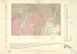
![[Monroe County, Indiana, existing use of land.] Sheet 10. Salt Creek Township, Monroe County, Indiana, existing use of land](https://iiif.uits.iu.edu/iiif/2/41688m61r%2Ffiles%2F794b5ec7-9465-4a56-a95f-23c98afc60dc/full/250,/0/default.jpg)
![[Monroe County, Indiana, existing use of land.] Sheet 5. Richland Township, Monroe County, Indiana, existing use of land](https://iiif.uits.iu.edu/iiif/2/2z10xt559%2Ffiles%2Fccd422c0-2373-4819-b6e9-60a0db266735/full/250,/0/default.jpg)
![[Monroe County, Indiana, existing use of land.] Sheet 9. Polk Township, Monroe County, Indiana, existing use of land](https://iiif.uits.iu.edu/iiif/2/th83n346m%2Ffiles%2F98da6cf6-258c-482d-aae7-a3cd05bc5456/full/250,/0/default.jpg)
![[Monroe County, Indiana, existing use of land.] Sheet 3. Perry Township, Monroe County, Indiana, existing use of land](https://iiif.uits.iu.edu/iiif/2/v405tf204%2Ffiles%2Fbadb621b-741e-4e53-9deb-4d9093251dcd/full/250,/0/default.jpg)
![Monroe County, Indiana, existing use of land. Sheet 1 [Index map]](https://iiif.uits.iu.edu/iiif/2/m039m802g%2Ffiles%2F61ffcc89-f677-469c-9d08-e45a2fe17a72/full/250,/0/default.jpg)
![[Monroe County, Indiana, existing use of land.] Sheet 7. Indian Creek Township, Monroe County, Indiana, existing use of land](https://iiif.uits.iu.edu/iiif/2/k356b6509%2Ffiles%2Fb57dc2b2-49f8-4d22-945b-30cd2e61374f/full/250,/0/default.jpg)
![[Monroe County, Indiana, existing use of land.] Sheet 8. Clear Creek Township, Monroe County, Indiana, existing use of land](https://iiif.uits.iu.edu/iiif/2/3r075z830%2Ffiles%2F6624980a-c7ac-4eaf-bb62-798890fa2939/full/250,/0/default.jpg)
Limit your search
- 1961[remove]154
- 0-99 pages154
- Schellie Associates. Monroe County Indiana, Existing Use of Land. [Bloomington, Indiana] : Monroe County Plan Commission, 1961.11
- Indiana state highway system1
- Indiana. Geological Survey. Regional geologic map.1
- Monroe County, Indiana, Existing Use of Land1
- Regional geologic map.1
- Salt Creek Township, Monroe County, Indiana, Existing Use of Land1