
Search Constraints
You searched for:
Subject
Topical Subject: Lakes
Remove constraint Subject: Topical Subject: Lakes
« Previous |
21 - 30 of 30
|
Next »
Search Results
-
- Subject:
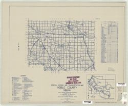
- Geographic Subject: Sylvan Lake (Ind.), Topical Subject: Roads, Topical Subject: Lakes, and Geographic Subject: Noble County (Ind.)
- Creator:
- Indiana. State Highway Commission (1919-1953)
- Publisher:
- State Highway Commission of Indiana
- Date Created:
- 1949
- Identifier:
- VAC3073-M-00264
- Genre:
- Road maps
- Geographic Location:
- Coordinates: W0853900 W0851200 N0413400 N0411600
- Related URL:
- Catalog URL: https://iucat.iu.edu/catalog/5707671
- Abstract:
- Blueline. "State roads revised to January 1, 1949." "1937." "Data obtained from State-wide Highway Planning Survey." Includes l...
- Call Number:
- G4093.N6 P2 1949 .I53
- Caption:
- Imprint: [Indianapolis?] : State Highway Commission of Indiana, 1949.
- Physical Description:
- Dimensions: 44 x 52 cm and Scale: 1:130,000
- Alternate Identifier:
- Title Control Number: a5707671
- Persistent URL:
- https://purl.dlib.indiana.edu/iudl/images/VAC3073/VAC3073-M-00264
-
- Subject:
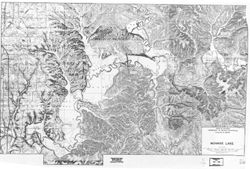
- Topical Subject: Lakes, Geographic Subject: Monroe, Lake (Ind.), and Topical Subject: Reservoirs
- Creator:
- Indiana. Department of Natural Resources. Division of Water
- Publisher:
- Indiana. Department of Natural Resources. Division of Water
- Date Created:
- 1986
- Identifier:
- VAC3073-M-00240
- Genre:
- Thematic maps and Bathymetric maps
- Geographic Location:
- Coordinates: W0863228 W0861911 N0390634 N0385928
- Related URL:
- Catalog URL: https://iucat.iu.edu/catalog/5307088
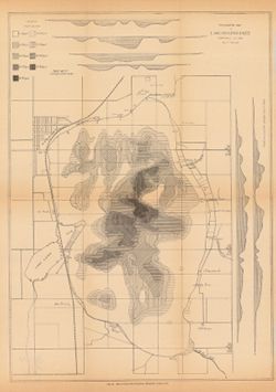
- Abstract:
- Xerographic copy. Relief shown by contours and spot heights. "1986." Map created from US Geological Survey topographic quadrangles for ...
- Call Number:
- G4092.M6 C3 1986 .I53
- Caption:
- Imprint: [Indianapolis] : The Division, [1986]
- Physical Description:
- Scale: 1:24,000 and Dimensions: 59 x 89 cm
- Alternate Identifier:
- Title Control Number: a5307088
- Persistent URL:
- https://purl.dlib.indiana.edu/iudl/images/VAC3073/VAC3073-M-00240
-
- Subject:
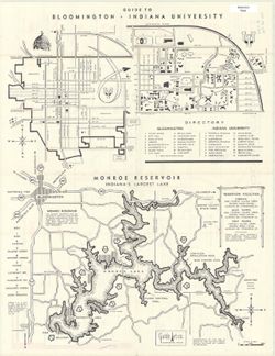
- Topical Subject: Lakes, Geographic Subject: Bloomington (Ind.), Geographic Subject: Monroe, Lake (Ind.), Topical Subject: Indiana University, Bloomington, Ge...
- Creator:
- Guide Art Co.
- Publisher:
- Guide Art Co.
- Date Created:
- 1965
- Identifier:
- VAC3073-M-00229
- Genre:
- Thematic maps and Tourist maps
- Geographic Location:
- Coordinates: W0863432 W0861532 N0391115 N0390033
- Related URL:
- Catalog URL: https://iucat.iu.edu/catalog/5298952
- Abstract:
- Includes indexes to buildings and services, some indicated by pictorially.
- Call Number:
- G4094.B5 E635 1965 .G85
- Caption:
- Imprint: Bloomington, Ind. : Guide Art, [1965]
- Physical Description:
- Scale: Scales differ. and Dimensions: 44 x 56 cm
- Alternate Identifier:
- Title Control Number: a5298952
- Persistent URL:
- https://purl.dlib.indiana.edu/iudl/images/VAC3073/VAC3073-M-00229
-
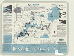
- Subject:
- Geographic Subject: Monroe, Lake (Ind.), Topical Subject: Lakes, and Topical Subject: Reservoirs
- Creator:
- Guide Art Co.
- Publisher:
- [publisher not identified]
- Date Created:
- 1971
- Identifier:
- VAC3073-M-00207
- Genre:
- Tourist maps and Pictorial maps
- Geographic Location:
- Coordinates: W0863238 W0861207 N0391240 N0385806
- Related URL:
- Catalog URL: https://iucat.iu.edu/catalog/5301880
- Abstract:
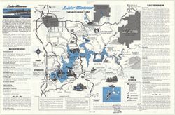
- Folded title: Tourist guide to Lake Monroe, Indiana's largest lake. Includes text, recreation information, and 9 recreation area maps. Advertisements...
- Call Number:
- G4092.M6E635 1971 .G8
- Caption:
- Imprint: Bloomington, Ind. : [publisher not identified], [1971]
- Physical Description:
- Dimensions: 43 x 56 cm and Scale: 1:80,000
- Alternate Identifier:
- Title Control Number: a5301880
- Persistent URL:
- https://purl.dlib.indiana.edu/iudl/images/VAC3073/VAC3073-M-00207
-
- Subject:
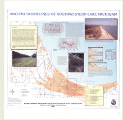
- Geographic Subject: Porter County (Ind.), Geographic Subject: Indiana, Geographic Subject: Michigan, Lake, Coast (Ind.), Topical Subject: Lakes, Topical Subj...
- Creator:
- Thompson, Todd A. (Todd Alan), 1959-
- Publisher:
- Indiana. Geological Survey
- Date Created:
- 2000
- Identifier:
- VAC3073-M-00193
- Genre:
- Thematic maps
- Geographic Location:
- Coordinates: W0873136 W0871307 N0414539 N0410943
- Related URL:
- Catalog URL: https://iucat.iu.edu/catalog/4898581
- Abstract:
- Includes illustrations, text, graphs showing "Lake-level fluctuations over the past 4,700 years" and a timeline showing historical events since 116...
- Call Number:
- G4093 .L3C2 2000 .T486
- Caption:
- Imprint: [Bloomington, Ind.] : Indiana University, Indiana Geological Survey, 2000.
- Physical Description:
- Dimensions: 76 x 87 cm and Scale: 1:59,000
- Alternate Identifier:
- Title Control Number: a4898581
- Persistent URL:
- https://purl.dlib.indiana.edu/iudl/images/VAC3073/VAC3073-M-00193
-
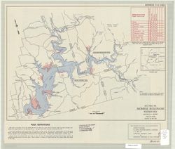
- Subject:
- Topical Subject: Reservoirs, Geographic Subject: Monroe, Lake (Ind.), and Topical Subject: Lakes
- Creator:
- United States. Army. Corps of Engineers. Louisville District
- Publisher:
- United States. Army. Corps of Engineers
- Date Created:
- 1965
- Identifier:
- VAC3073-M-00118
- Genre:
- Maps
- Geographic Location:
- Coordinates: W0863242 W0861509 N0390928 N0390024
- Related URL:
- Catalog URL: https://iucat.iu.edu/catalog/5302360
- Abstract:
- Includes "Recreation sites" table, "Vicinity map", and text on recto. Includes text, illustrations, "Section along centerline of out...
- Call Number:
- G4092.M6 1965 .U5
- Caption:
- Imprint: [Louisville, Ky.?] : U.S. Army Corps of Engineers, [1965]
- Physical Description:
- Scale: 1:80,000 and Dimensions: 32 x 44 cm
- Alternate Identifier:
- Title Control Number: a5302360
- Persistent URL:
- https://purl.dlib.indiana.edu/iudl/images/VAC3073/VAC3073-M-00118
-
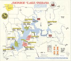
- Subject:
- Topical Subject: Lakes, Geographic Subject: Indiana, Topical Subject: Reservoirs, and Geographic Subject: Monroe, Lake (Ind.)
- Creator:
- United States. Army. Corps of Engineers. Louisville District
- Date Created:
- 1970
- Identifier:
- VAC3073-M-00109
- Genre:
- Thematic maps
- Geographic Location:
- Coordinates: W0863045 W0863036 N0390034 N0390024
- Related URL:
- Catalog URL: https://iucat.iu.edu/catalog/6064107
- Abstract:
- Text, illustrations, and vicinity map on verso.
- Call Number:
- G4092.M6E63 1970 .U5
- Caption:
- Imprint: Louisville, Ky.: The Corps., 197-?.
- Physical Description:
- Scale: Approximately 1:77,000 and Dimensions: 39 x 45 cm
- Alternate Identifier:
- Title Control Number: a6064107
- Persistent URL:
- https://purl.dlib.indiana.edu/iudl/images/VAC3073/VAC3073-M-00109
-
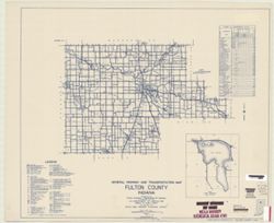
- Subject:
- Topical Subject: Roads, Geographic Subject: Lake Manitou (Ind.), Geographic Subject: Fulton County (Ind.), and Topical Subject: Lakes
- Creator:
- Indiana. State Highway Commission (1919-1953)
- Publisher:
- State Highway Commission of Indiana
- Date Created:
- 1949
- Identifier:
- VAC3073-M-00031
- Genre:
- Road maps
- Geographic Location:
- Coordinates: W0862800 W0855700 N0411000 N0405500
- Related URL:
- Catalog URL: https://iucat.iu.edu/catalog/5705922
- Abstract:
- Blueline. "State road revised to January 1, 1949." "Data obtained from Statewide Highway Planning Survey." Includes chart, "Culture ...
- Call Number:
- G4093.F8P2 1949 .I53
- Caption:
- Imprint: [Indianapolis, IN] : State Highway Commission of Indiana, 1949.
- Physical Description:
- Dimensions: 44 x 52 cm and Scale: 1:130,000
- Alternate Identifier:
- Title Control Number: a5705922
- Persistent URL:
- https://purl.dlib.indiana.edu/iudl/images/VAC3073/VAC3073-M-00031
-
- Subject:
- Topical Subject: Reservoirs, Geographic Subject: Bloomington Region (Ind.), Topical Subject: Lakes, and Geographic Subject: Monroe, Lake (Ind.)
- Creator:
- Guide Art Co. and Skirvin, Jack E.
- Publisher:
- Guide Art Co.
- Date Created:
- 1980
- Identifier:
- VAC3073-M-00012
- Genre:
- Pictorial maps and Tourist maps
- Geographic Location:
- Coordinates: W0863115 W0861826 N0390718 N0385940
- Related URL:
- Catalog URL: https://iucat.iu.edu/catalog/5302210
- Abstract:
- Text, advertisements, and 9 Lake Monroe area maps showing businesses on verso.
- Call Number:
- G4092.M6 E635 1980 .G85
- Caption:
- Imprint: Bloomington, Ind. : Guide Art Co., c1980.
- Physical Description:
- Dimensions: on sheet 28 x 44 cm and Scale: 1:125,000
- Alternate Identifier:
- Title Control Number: a5302210
- Persistent URL:
- https://purl.dlib.indiana.edu/iudl/images/VAC3073/VAC3073-M-00012
-
- Subject:
- Geographic Subject: Maxinkuckee, Lake (Ind.), Topical Subject: IGS Annual Reports, Topical Subject: Lakes, Geographic Subject: Marshall County (Ind.), Geogra...
- Creator:
- Scovell, J. T. (Josiah Thomas), 1841-
- Publisher:
- Indiana. Department of Geology and Natural Resources
- Date Created:
- 1901
- Identifier:
- VAC3073-M-00003
- Genre:
- Bathymetric maps and Topographic maps
- Geographic Location:
- Coordinates: W0862605 W0862248 N0411337 N0411052
- Related URL:
- Catalog URL: https://iucat.iu.edu/catalog/18279165
- Abstract:
- Depth shown by isolines, patterning, and profile. In addition to Lake Maxinkuckee, the map shows local sites including Marmont (now Culver), a railroad, mill...
- Call Number:
- G4092.M33 1900 .S36
- Caption:
- Imprint: [Indianapolis] : [Indiana. Department of Geology and Natural Resources], [1901]
- Physical Description:
- Scale: Approximately 1:14,630 and Dimensions: on sheet 44 x 33 cm
- Alternate Identifier:
- Title Control Number: a18279165 and Alternate ID: 390726IP
- Persistent URL:
- https://purl.dlib.indiana.edu/iudl/images/VAC3073/VAC3073-M-00003
- Provenance:
- 25th Annual Report (1900) / Indiana. Department of Geology and Natural Resources.

- « Previous
- Next »
- 1
- 2
- 3