
Search Constraints
You searched for:
Publisher
Главное управление геодезии и картографии при СНК СССР
Remove constraint Publisher: Главное управление геодезии и картографии при СНК СССР
« Previous |
1 - 10 of 189
|
Next »
Search Results
-
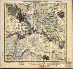
- Description:
- 1938
- Subject:
- Topical Subject: Maps, Topical Subject: Soviet Union, and Geographic Subject: Slavyansk-na-Kubani
- Publisher:
- Главное управление геодезии и картографии при СНК СССР
- Language:
- Russian
- Date Created:
- 1941
- Identifier:
- VAC9619-002360
- Genre:
- Topographic Maps and Military Maps
- Geographic Location:
- Coordinates: 45, 38, 45.333, 38.5
- Related URL:
- Catalog URL: https://iucat.iu.edu/catalog/5020129 and Download GeoTIFF: https://drive.google.com/file/d/1dDVpO5eXZ3hvJ1_1_fgMwdPJLC9kNLZ3/view?usp=sharing
- Abstract:
- Modern area represented: Slavyansk-na-Kubani, Russia
- Call Number:
- G7000 s100 .S7 sheet L-37-101
- Caption:
- Для служебного пользования
- City:
- Славянская (Slavyanskaya)
- Copyright Holder:
- No Copyright - United States
- Country:
- СССР (USSR)
- State/Province:
- РСФСР (RSFSR) and Краснодарский край (Krasnodar kray)
- Physical Description:
- Scale: 1:100,000
- Persistent URL:
- http://purl.dlib.indiana.edu/iudl/images/VAC9619/VAC9619-002360
- Provenance:
- CIA Map Library, Library of Congress Geography & Map Division
-
- Description:
- 1940
- Subject:
- Topical Subject: Soviet Union, Geographic Subject: Pashkovskaya, and Topical Subject: Maps
- Publisher:
- Главное управление геодезии и картографии при СНК СССР
- Language:
- Russian
- Date Created:
- 1941
- Identifier:
- VAC9619-002361
- Genre:
- Military Maps and Topographic Maps
- Geographic Location:
- Coordinates: 45, 39, 45.333, 39.5
- Related URL:
- Download GeoTIFF: https://drive.google.com/file/d/1qj8vccZtr5i4G21hUZIBa-EU9JUlKk6w/view?usp=sharing and Catalog URL: https://iucat.iu.edu/catalog/5020129
- Abstract:
- Modern area represented: Pashkovskaya, Russia
- Call Number:
- G7000 s100 .S7 sheet L-37-103
- Caption:
- Для служебного пользования
- City:
- Пашковская (Pashkovskaya)
- Copyright Holder:
- No Copyright - United States
- Country:
- СССР (USSR)
- State/Province:
- Краснодарский край (Krasnodar kray) and РСФСР (RSFSR)
- Physical Description:
- Scale: 1:100,000
- Persistent URL:
- http://purl.dlib.indiana.edu/iudl/images/VAC9619/VAC9619-002361
- Provenance:
- DMA Topographic Center, Army Map Service Library, Heeresplankammer Gruppe Archive Auslandskartenarchiv
-
- Description:
- 1926
- Subject:
- Geographic Subject: Azov, Geographic Subject: Rostov oblast, Topical Subject: Soviet Union, and Topical Subject: Maps
- Publisher:
- Главное управление геодезии и картографии при СНК СССР
- Language:
- Russian
- Date Created:
- 1940
- Identifier:
- VAC9619-002285
- Genre:
- Topographic Maps and Military Maps
- Geographic Location:
- Coordinates: 47, 39, 47.3333, 39.5
- Related URL:
- Download GeoTIFF: https://drive.google.com/file/d/1ZVtvAnypf4ZFXI2NppFs0SerXf00lb1Z/view?usp=sharing and Catalog URL: https://iucat.iu.edu/catalog/5020129
- Abstract:
- Modern area represented: Azov, Russia
- Call Number:
- G7000 s100 .S7 sheet L-37-31
- Caption:
- Для служебного пользования
- City:
- Азов (Azov)
- Copyright Holder:
- No Copyright - United States
- Country:
- СССР (USSR)
- State/Province:
- Ростовская область (Rostov oblast) and РСФСР (RSFSR)
- Physical Description:
- Scale: 1:100,000
- Persistent URL:
- http://purl.dlib.indiana.edu/iudl/images/VAC9619/VAC9619-002285
- Provenance:
- Geographic Names Branch, Heeresplankammer 1. Abt. (Pl. A.) Auslandskartenarchiv
-
- Description:
- 1926
- Subject:
- Topical Subject: Soviet Union, Topical Subject: Maps, and Geographic Subject: Rostov
- Publisher:
- Главное управление геодезии и картографии при СНК СССР
- Language:
- Russian
- Date Created:
- 1941
- Identifier:
- VAC9619-002286
- Genre:
- Topographic Maps and Military Maps
- Geographic Location:
- Coordinates: 47, 39.5, 47.3333, 40
- Related URL:
- Catalog URL: https://iucat.iu.edu/catalog/5020129 and Download GeoTIFF: https://drive.google.com/file/d/1XcqLQR-DzZL4b2V2aY4UGhly62ywbl77/view?usp=sharing
- Abstract:
- Modern area represented: Rostov, Russia
- Call Number:
- G7000 s100 .S7 sheet L-37-32
- Caption:
- Для служебного пользования
- City:
- Ростов (Rostov)
- Copyright Holder:
- No Copyright - United States
- Country:
- СССР (USSR)
- State/Province:
- Ростовская область (Rostov oblast) and РСФСР (RSFSR)
- Physical Description:
- Scale: 1:100,000
- Persistent URL:
- http://purl.dlib.indiana.edu/iudl/images/VAC9619/VAC9619-002286
- Provenance:
- DMA Topographic Center, Army Map Service Library
-
- Description:
- 1935
- Subject:
- Geographic Subject: Aleksandrovka, Topical Subject: Maps, and Topical Subject: Soviet Union
- Publisher:
- Главное управление геодезии и картографии при СНК СССР
- Language:
- Russian
- Date Created:
- 1940
- Identifier:
- VAC9619-002294
- Genre:
- Military Maps and Topographic Maps
- Geographic Location:
- Coordinates: 46.6667, 39, 47, 39.5
- Related URL:
- Catalog URL: https://iucat.iu.edu/catalog/5020129 and Download GeoTIFF: https://drive.google.com/file/d/12RMoPzLmycgdNa_ZeRr0BYWXrRKFao9C/view?usp=sharing
- Abstract:
- Modern area represented: Aleksandrovka, Krasnodar kray, Russia
- Call Number:
- G7000 s100 .S7 sheet L-37-43
- Caption:
- Для служебного пользования
- City:
- Александровка (Aleksandrovka)
- Copyright Holder:
- No Copyright - United States
- Country:
- СССР (USSR)
- State/Province:
- Краснодарский край (Krasnodar kray), Ростовская область (Rostov oblast), and РСФСР (RSFSR)
- Physical Description:
- Scale: 1:100,000
- Persistent URL:
- http://purl.dlib.indiana.edu/iudl/images/VAC9619/VAC9619-002294
- Provenance:
- DMA Topographic Center, Army Map Service Library, OMAHA, Library of Congress Geography & Map Division
-
- Description:
- 1935
- Subject:
- Topical Subject: Maps, Topical Subject: Soviet Union, and Geographic Subject: Kamyshevatskaya
- Publisher:
- Главное управление геодезии и картографии при СНК СССР
- Language:
- Russian
- Date Created:
- 1940
- Identifier:
- VAC9619-002469
- Genre:
- Topographic Maps and Military Maps
- Geographic Location:
- Coordinates: 46.333, 37.5, 46.667, 38
- Related URL:
- Catalog URL: https://iucat.iu.edu/catalog/5020129 and Download GeoTIFF: https://drive.google.com/file/d/1FZNP0AszmtgO2r8VCGGm5F4L25pPyivc/view?usp=sharing
- Abstract:
- Modern area represented: Kamyshevatskaya, Russia
- Call Number:
- G7000 s100 .S7 sheet L-37-52
- Caption:
- Для служебного пользования
- City:
- Станница Камышеватская (Kamyshevatskaya)
- Copyright Holder:
- No Copyright - United States
- Country:
- СССР (USSR)
- State/Province:
- Краснодарский край (Krasnodar kray) and РСФСР (RSFSR)
- Physical Description:
- Scale: 1:100,000
- Persistent URL:
- http://purl.dlib.indiana.edu/iudl/images/VAC9619/VAC9619-002469
- Provenance:
- DMA Topographic Center, Library of Congress G & M Division, OMAHA, Army Map Service Library
-
- Description:
- 1935
- Subject:
- Topical Subject: Maps, Geographic Subject: Primorsko-Akhtarsk, and Topical Subject: Soviet Union
- Publisher:
- Главное управление геодезии и картографии при СНК СССР
- Language:
- Russian
- Date Created:
- 1941
- Identifier:
- VAC9619-002328
- Genre:
- Topographic Maps and Military Maps
- Geographic Location:
- Coordinates: 46, 38, 46.3333, 38.5
- Related URL:
- Catalog URL: https://iucat.iu.edu/catalog/5020129 and Download GeoTIFF: https://drive.google.com/file/d/1ewOVZfHJkultmnEPuV5g1xtQzXm1FKEb/view?usp=sharing
- Abstract:
- Modern area represented: Primorsko-Akhtarsk, Russia
- Call Number:
- G7000 s100 .S7 sheet L-37-65
- Caption:
- Для служебного пользования
- City:
- Приморско-Ахтарская (Primorsko-Akhtarskaya)
- Copyright Holder:
- No Copyright - United States
- Country:
- СССР (USSR)
- State/Province:
- Краснодарский край (Krasnodar kray) and РСФСР (RSFSR)
- Physical Description:
- Scale: 1:100,000
- Persistent URL:
- http://purl.dlib.indiana.edu/iudl/images/VAC9619/VAC9619-002328
- Provenance:
- DMA Topographic Center, Army Map Service Library
-
- Description:
- 1925
- Subject:
- Topical Subject: Maps, Topical Subject: Soviet Union, and Geographic Subject: Belaya Glina
- Publisher:
- Главное управление геодезии и картографии при СНК СССР
- Language:
- Russian
- Date Created:
- 1941
- Identifier:
- VAC9619-002332
- Genre:
- Topographic Maps and Military Maps
- Geographic Location:
- Coordinates: 46, 40.5, 46.3333, 41
- Related URL:
- Download GeoTIFF: https://drive.google.com/file/d/16ok6NmTf8d6f0gWQVCGVYyo4CYtRyilo/view?usp=sharing and Catalog URL: https://iucat.iu.edu/catalog/5020129
- Abstract:
- Modern area represented: Belaya Glina, Russia
- Call Number:
- G7000 s100 .S7 sheet L-37-70
- Caption:
- Для служебного пользования
- City:
- Белая Глина (Belaya Glina)
- Copyright Holder:
- No Copyright - United States
- Country:
- СССР (USSR)
- State/Province:
- Краснодарский край (Krasnodar kray), Ростовская область (Rostov oblast), and РСФСР (RSFSR)
- Physical Description:
- Scale: 1:100,000
- Persistent URL:
- http://purl.dlib.indiana.edu/iudl/images/VAC9619/VAC9619-002332
- Provenance:
- DMA Topographic Center, Army Map Service Library
-
- Description:
- 1936
- Subject:
- Topical Subject: Maps, Geographic Subject: Stepnaya, and Topical Subject: Soviet Union
- Publisher:
- Главное управление геодезии и картографии при СНК СССР
- Language:
- Russian
- Date Created:
- 1941
- Identifier:
- VAC9619-002337
- Genre:
- Topographic Maps and Military Maps
- Geographic Location:
- Coordinates: 45.667, 38, 46, 38.5
- Related URL:
- Catalog URL: https://iucat.iu.edu/catalog/5020129 and Download GeoTIFF: https://drive.google.com/file/d/1JbpHtvnICqALvD_ZX180f74-4Ca2Qrxr/view?usp=sharing
- Abstract:
- Modern area represented: Stepnaya, Russia
- Call Number:
- G7000 s100 .S7 sheet L-37-77
- Caption:
- Для служебного пользования
- City:
- Степная (Stepnaya)
- Copyright Holder:
- No Copyright - United States
- Country:
- СССР (USSR)
- State/Province:
- Краснодарский край (Krasnodar kray) and РСФСР (RSFSR)
- Physical Description:
- Scale: 1:100,000
- Persistent URL:
- http://purl.dlib.indiana.edu/iudl/images/VAC9619/VAC9619-002337
- Provenance:
- DMA Topographic Center, Army Map Service Library
-
- Description:
- 1936
- Subject:
- Topical Subject: Soviet Union, Geographic Subject: Rogovskaya, and Topical Subject: Maps
- Publisher:
- Главное управление геодезии и картографии при СНК СССР
- Language:
- Russian
- Date Created:
- 1940
- Identifier:
- VAC9619-002338
- Genre:
- Topographic Maps and Military Maps
- Geographic Location:
- Coordinates: 45.667, 38.5, 46, 39
- Related URL:
- Download GeoTIFF: https://drive.google.com/file/d/1Z_my8K4ECfFywgELXq5ypJAneao9d9kI/view?usp=sharing and Catalog URL: https://iucat.iu.edu/catalog/5020129
- Abstract:
- Modern area represented: Rogovskaya, Russia
- Call Number:
- G7000 s100 .S7 sheet L-37-78
- Caption:
- Для служебного пользования
- City:
- Станица Роговская (Stanitsa Rogovskaya)
- Copyright Holder:
- No Copyright - United States
- Country:
- СССР (USSR)
- State/Province:
- РСФСР (RSFSR) and Краснодарский край (Krasnodar kray)
- Physical Description:
- Scale: 1:100,000
- Persistent URL:
- http://purl.dlib.indiana.edu/iudl/images/VAC9619/VAC9619-002338
- Provenance:
- Army Map Service Library
