Records of Indiana University president. Organized in two series, the collection primarily consists of incoming correspondence during Swain's tenure. Include...
The bulk of Indiana University’s Russian Military Topographic Map Collection is made up of the Soviet Red Army topographic maps, which were produced for defense and economic planning. This collection came to Indiana University from the duplicate map room of the Library of Congress Map Collection in the early 1990s. These maps cover not only parts of Russia and Eastern Europe, but extend as far north as Scandinavia, as far west as Germany and the Netherlands, and as far south as Iran.
View an interactive index map of the collection (https://iu.maps.arcgis.com/apps/webappviewer/index.html?id=3003eaf8107048aeabd74b74a1481cb4).
This project was supported by a Digitizing Hidden Collections grant from the Council on Library and Information Resources (CLIR). The grant program is made possible by funding from The Andrew W. Mellon Foundation.
William V. S. Tubman (1895-1971), Liberia’s longest serving President, served from 1944–1971. Tubman’s presidency was marked by great changes in the economy,...
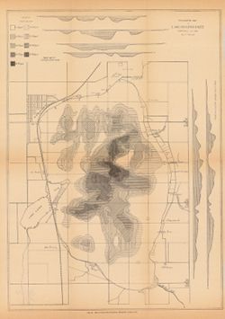
The IUB Map Collections contain digitized public domain maps from the Indiana University Bloomington Libraries print map collections. Maps in the digital collection range from the early nineteenth century to the present and feature: Geologic, topographic, and highway maps of Indiana in the Indiana Historic Maps Collection; Russian military topographic maps produced for defense and economic planning in the Russian Military Topographic Map Collection. The print IUB Map Collections are located on the 2nd floor of the East Tower of the Herman B Wells Library, 1320 East Tenth Street, Bloomington, Indiana 47405. To suggest maps to add to the digital collection or for more information, please contact us at libmaps@iu.edu.
Indiana Historic Maps provides images of a small portion of maps that focus on Indiana. The majority of this collection focuses on maps produced prior to 1923 unless known to be in the public domain as state or federal documents. In addition, Indiana University Bloomington holds an outstanding collection of print maps by and about geographic areas covering the state of Indiana. Most well known of these are the Sanborn Fire Insurance maps which have been digitized through 1923 and now available at: https://libraries.indiana.edu/union-list-sanborn-maps. In addition we own many maps produced by Indiana State government agencies including state and county highway maps, IGS geologic maps and DNR park maps; U.S. Federal agencies such as the USGS topographic maps, Congressional survey maps and AMS maps from the 1940s; as well as privately produced maps for the state but also cities and counties.
The first president of what was then Indiana College was elected by the Board of Trustees in 1829. Herman B Wells was named interim president in 1937 and pre...
The Meier mss., 1927-2010, consists of the correspondence and papers of education reformer Deborah W. Meier (1931-), who is frequently credited with founding...
The collection consists of correspondence, reports, records, minutes, and other miscellaneous manuscript items. These materials are typically either photocop...

 6470Works
 262Works
 811Works
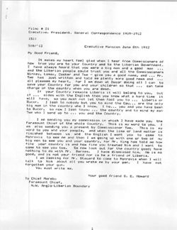 533Works