
Search Constraints
You searched for:
Provenance
DMA Topographic Center, Army Map Service Library
Remove constraint Provenance: DMA Topographic Center, Army Map Service Library
« Previous |
1 - 10 of 221
|
Next »
Search Results
-
- Description:
- 1889
- Subject:
- Topical Subject: Maps, Topical Subject: Soviet Union, Geographic Subject: Republic of Crimea, and Geographic Subject: Simferopol
- Publisher:
- Генеральный штаб Красной Армии
- Language:
- Russian
- Date Created:
- 1941
- Identifier:
- VAC9619-001964
- Genre:
- Military Maps and Topographic Maps
- Geographic Location:
- Coordinates: 44.6667, 34, 45, 34.5
- Related URL:
- Catalog URL: https://iucat.iu.edu/catalog/5020129 and Download GeoTIFF: https://drive.google.com/file/d/1amvhrChXpoTfj7psOh9J6iw00E8WWa7q/view?usp=sharing
- Abstract:
- Modern area represented: Simferopol, Republic of Crimea, Ukraine
- Call Number:
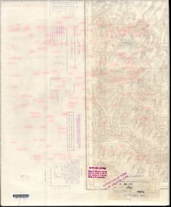
- G7000 s100 .S7 sheet L-36-117
- Caption:
- Для служебного пользования
- City:
- Симферополь (Simferopol)
- Copyright Holder:
- No Copyright - United States
- Country:
- СССР (USSR)
- State/Province:
- Крымская АССР (Crimean Autonomous Soviet Socialist Republic) and РСФСР (RSFSR)
- Physical Description:
- Scale: 1:100,000
- Persistent URL:
- http://purl.dlib.indiana.edu/iudl/images/VAC9619/VAC9619-001964
- Provenance:
- DMA Topographic Center, Army Map Service Library
-
- Description:
- 1929
- Subject:
- Geographic Subject: Троїцьке (Troyitske), Topical Subject: Soviet Union, and Topical Subject: Maps
- Publisher:
- Управление военных топографов
- Language:
- Russian
- Identifier:
- VAC9619-000120
- Genre:
- Topographic Maps and Military Maps
- Geographic Location:
- Coordinates: 46.5, 30, 46.6667, 30.25
- Related URL:
- Catalog URL: http://iucat.iu.edu/catalog/5020131, Download GeoTIFF: https://drive.google.com/open?id=1UDMuWV6KgCLjaqKbjycJK5oUTerwh9NA, and https://drive.goo...
- Abstract:
- Modern area represented: Troyitske, Odessa oblast, Ukraine
- Call Number:
- G7000 s50 .S68 sheet L-36-49-A
- Caption:
- Не подлежит оглашению,Секретно
- City:
- Троицкое (Troitskoye)
- Copyright Holder:
- No Copyright - United States
- Country:
- СССР (USSR)
- State/Province:
- Одесская область (Odessa oblast) and Украинская ССР (Ukrainian Soviet Socialist Republic)
- Physical Description:
- Scale: 1:50,000
- Persistent URL:
- http://purl.dlib.indiana.edu/iudl/images/VAC9619/VAC9619-000120
- Provenance:
- DMA Topographic Center, Army Map Service Library
-
- Description:
- 1926
- Subject:
- Topical Subject: Maps, Geographic Subject: Grushevskaya, and Topical Subject: Soviet Union
- Publisher:
- Генеральный штаб Красной Армии
- Language:
- Russian
- Date Created:
- 1941
- Identifier:
- VAC9619-002006
- Genre:
- Topographic Maps and Military Maps
- Geographic Location:
- Coordinates: 47.3333, 39.5, 47.6667, 40
- Related URL:
- Catalog URL: https://iucat.iu.edu/catalog/5020129 and Download GeoTIFF: https://drive.google.com/open?id=142dOU_I0P9WXPhKJgiCrx-ldSjSb1GRW
- Abstract:
- Modern area represented: Grushevskaya, Rostov oblast, Russia
- Call Number:
- G7000 s100 .S7 sheet L-37-20
- Caption:
- Для служебного пользования
- City:
- Грушевская (Grushevskaya)
- Copyright Holder:
- No Copyright - United States
- Country:
- СССР (USSR)
- State/Province:
- Ростовская область (Rostov oblast) and РСФСР (RSFSR)
- Physical Description:
- Scale: 1:100,000
- Persistent URL:
- http://purl.dlib.indiana.edu/iudl/images/VAC9619/VAC9619-002006
- Provenance:
- DMA Topographic Center, Army Map Service Library
-
- Description:
- 1926
- Subject:
- Topical Subject: Soviet Union, Topical Subject: Maps, and Geographic Subject: Rostov
- Publisher:
- Главное управление геодезии и картографии при СНК СССР
- Language:
- Russian
- Date Created:
- 1941
- Identifier:
- VAC9619-002286
- Genre:
- Topographic Maps and Military Maps
- Geographic Location:
- Coordinates: 47, 39.5, 47.3333, 40
- Related URL:
- Catalog URL: https://iucat.iu.edu/catalog/5020129 and Download GeoTIFF: https://drive.google.com/file/d/1XcqLQR-DzZL4b2V2aY4UGhly62ywbl77/view?usp=sharing
- Abstract:
- Modern area represented: Rostov, Russia
- Call Number:
- G7000 s100 .S7 sheet L-37-32
- Caption:
- Для служебного пользования
- City:
- Ростов (Rostov)
- Copyright Holder:
- No Copyright - United States
- Country:
- СССР (USSR)
- State/Province:
- Ростовская область (Rostov oblast) and РСФСР (RSFSR)
- Physical Description:
- Scale: 1:100,000
- Persistent URL:
- http://purl.dlib.indiana.edu/iudl/images/VAC9619/VAC9619-002286
- Provenance:
- DMA Topographic Center, Army Map Service Library
-
- Description:
- 1926
- Subject:
- Geographic Subject: Zhuravlyovka, Topical Subject: Soviet Union, and Topical Subject: Maps
- Publisher:
- Генеральный штаб Красной Армии
- Language:
- Russian
- Date Created:
- 1941
- Identifier:
- VAC9619-002299
- Genre:
- Military Maps and Topographic Maps
- Geographic Location:
- Coordinates: 46.6667, 41, 47, 41.5
- Related URL:
- Catalog URL: https://iucat.iu.edu/catalog/5020129 and Download GeoTIFF: https://drive.google.com/file/d/1RZe7TX8nGnwp5iv7M1fYWr1GLhQJkoo7/view?usp=sharing
- Abstract:
- Modern area represented: Zhuravlyovka, Russia
- Call Number:
- G7000 s100 .S7 sheet L-37-47
- Caption:
- Для служебного пользования
- City:
- Журавлевка (Zhuravlyovka)
- Copyright Holder:
- No Copyright - United States
- Country:
- СССР (USSR)
- State/Province:
- Ростовская область (Rostov oblast) and РСФСР (RSFSR)
- Physical Description:
- Scale: 1:100,000
- Persistent URL:
- http://purl.dlib.indiana.edu/iudl/images/VAC9619/VAC9619-002299
- Provenance:
- DMA Topographic Center, Army Map Service Library
-
- Description:
- 1935
- Subject:
- Topical Subject: Soviet Union, Geographic Subject: Yasenskaya, and Topical Subject: Maps
- Publisher:
- Генеральный штаб Красной Армии
- Language:
- Russian
- Date Created:
- 1940
- Identifier:
- VAC9619-002320
- Genre:
- Military Maps and Topographic Maps
- Geographic Location:
- Coordinates: 46.3333, 38, 46.6667, 38.5
- Related URL:
- Catalog URL: https://iucat.iu.edu/catalog/5020129 and Download GeoTIFF: https://drive.google.com/file/d/1ANfBQuPlscLZ3TLWYKArV4_UX4oV-Ab6/view?usp=sharing
- Abstract:
- Modern area represented: Yasenskaya, Russia
- Call Number:
- G7000 s100 .S7 sheet L-37-53
- Caption:
- Для служебного пользования
- City:
- Ст-ца Ясенская (Yasenskaya)
- Copyright Holder:
- No Copyright - United States
- Country:
- СССР (USSR)
- State/Province:
- РСФСР (RSFSR) and Краснодарский край (Krasnodar kray)
- Physical Description:
- Scale: 1:100,000
- Persistent URL:
- http://purl.dlib.indiana.edu/iudl/images/VAC9619/VAC9619-002320
- Provenance:
- DMA Topographic Center, Army Map Service Library
-
- Description:
- 1935
- Subject:
- Topical Subject: Soviet Union, Topical Subject: Maps, and Geographic Subject: Staroshcherbinovskaya
- Publisher:
- Генеральный штаб Красной Армии
- Language:
- Russian
- Date Created:
- 1940
- Identifier:
- VAC9619-002321
- Genre:
- Military Maps and Topographic Maps
- Geographic Location:
- Coordinates: 46.3333, 38.5, 46.6667, 39
- Related URL:
- Catalog URL: https://iucat.iu.edu/catalog/5020129 and Download GeoTIFF: https://drive.google.com/file/d/1ra_mJa5O-R4zF0rl3TtNkSQRl0GDEvcn/view?usp=sharing
- Abstract:
- Modern area represented: Staroshcherbinovskaya, Russia
- Call Number:
- G7000 s100 .S7 sheet L-37-54
- Caption:
- Для служебного пользования
- City:
- Ст-ца Старо-Щербиновская (Staro-Shcherbinovskaya)
- Copyright Holder:
- No Copyright - United States
- Country:
- СССР (USSR)
- State/Province:
- РСФСР (RSFSR), Краснодарский край (Krasnodar kray), and Ростовская область (Rostov oblast)
- Physical Description:
- Scale: 1:100,000
- Persistent URL:
- http://purl.dlib.indiana.edu/iudl/images/VAC9619/VAC9619-002321
- Provenance:
- DMA Topographic Center, Army Map Service Library
-
- Description:
- 1935
- Subject:
- Topical Subject: Maps, Geographic Subject: Primorsko-Akhtarsk, and Topical Subject: Soviet Union
- Publisher:
- Главное управление геодезии и картографии при СНК СССР
- Language:
- Russian
- Date Created:
- 1941
- Identifier:
- VAC9619-002328
- Genre:
- Topographic Maps and Military Maps
- Geographic Location:
- Coordinates: 46, 38, 46.3333, 38.5
- Related URL:
- Catalog URL: https://iucat.iu.edu/catalog/5020129 and Download GeoTIFF: https://drive.google.com/file/d/1ewOVZfHJkultmnEPuV5g1xtQzXm1FKEb/view?usp=sharing
- Abstract:
- Modern area represented: Primorsko-Akhtarsk, Russia
- Call Number:
- G7000 s100 .S7 sheet L-37-65
- Caption:
- Для служебного пользования
- City:
- Приморско-Ахтарская (Primorsko-Akhtarskaya)
- Copyright Holder:
- No Copyright - United States
- Country:
- СССР (USSR)
- State/Province:
- Краснодарский край (Krasnodar kray) and РСФСР (RSFSR)
- Physical Description:
- Scale: 1:100,000
- Persistent URL:
- http://purl.dlib.indiana.edu/iudl/images/VAC9619/VAC9619-002328
- Provenance:
- DMA Topographic Center, Army Map Service Library
-
- Description:
- 1940
- Subject:
- Topical Subject: Soviet Union, Geographic Subject: Leningradskaya, and Topical Subject: Maps
- Publisher:
- Генеральный штаб Красной Армии
- Language:
- Russian
- Date Created:
- 1941
- Identifier:
- VAC9619-002329
- Genre:
- Military Maps and Topographic Maps
- Geographic Location:
- Coordinates: 46, 39, 46.3333, 39.5
- Related URL:
- Download GeoTIFF: https://drive.google.com/file/d/1O9ZH2ptxPJJ9cDyD-JH5mXSQdZcyF-6n/view?usp=sharing and Catalog URL: https://iucat.iu.edu/catalog/5020129
- Abstract:
- Modern area represented: Leningradskaya, Russia
- Call Number:
- G7000 s100 .S7 sheet L-37-67
- Caption:
- Для служебного пользования
- City:
- Ленинградская (Leningradskaya)
- Copyright Holder:
- No Copyright - United States
- Country:
- СССР (USSR)
- State/Province:
- Краснодарский край (Krasnodar kray) and РСФСР (RSFSR)
- Physical Description:
- Scale: 1:100,000
- Persistent URL:
- http://purl.dlib.indiana.edu/iudl/images/VAC9619/VAC9619-002329
- Provenance:
- DMA Topographic Center, Army Map Service Library
-
- Description:
- 1940
- Subject:
- Geographic Subject: Pavlovskaya, Topical Subject: Maps, and Topical Subject: Soviet Union
- Publisher:
- Генеральный штаб Красной Армии
- Language:
- Russian
- Date Created:
- 1941
- Identifier:
- VAC9619-002330
- Genre:
- Topographic Maps and Military Maps
- Geographic Location:
- Coordinates: 46, 39.5, 46.3333, 40
- Related URL:
- Download GeoTIFF: https://drive.google.com/file/d/1xbqEApJ5hSLMPVxfU-oodDof-dkkXh20/view?usp=sharing and Catalog URL: https://iucat.iu.edu/catalog/5020129
- Abstract:
- Modern area represented: Pavlovskaya, Russia
- Call Number:
- G7000 s100 .S7 sheet L-37-68
- Caption:
- Для служебного пользования
- City:
- Павловская (Pavlovskaya)
- Copyright Holder:
- No Copyright - United States
- Country:
- СССР (USSR)
- State/Province:
- Краснодарский край (Krasnodar kray) and РСФСР (RSFSR)
- Physical Description:
- Scale: 1:100,000
- Persistent URL:
- http://purl.dlib.indiana.edu/iudl/images/VAC9619/VAC9619-002330
- Provenance:
- DMA Topographic Center, Army Map Service Library
