
Search Constraints
You searched for:
Type
Image
Remove constraint Type: Image
Pages
0-99 pages
Remove constraint Pages: 0-99 pages
State/Province
Харьковская область (Kharkiv oblast)
Remove constraint State/Province: Харьковская область (Kharkiv oblast)
State
deposited
Remove constraint State: deposited
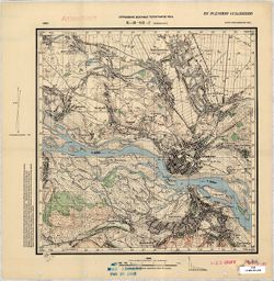
Search Results
-
- Description:
- 1931
- Subject:
- Geographic Subject: Prigarovka, Topical Subject: Soviet Union, and Topical Subject: Maps
- Publisher:
- Управление военных топографов
- Language:
- Russian
- Date Created:
- 1932
- Identifier:
- VAC9619-001075
- Genre:
- Military Maps and Topographic Maps
- Geographic Location:
- Coordinates: 49, 33.75, 49.167, 34
- Related URL:
- DataCORE Dataset Download: https://datacore.iu.edu/concern/data_sets/w37637645
- Abstract:
- Modern area represented: Prigarovka, Poltava oblast, Ukraine
- Call Number:
- G7000 s50 .S68 М-36-104-Г
- Caption:
- Не подлежит оглашению
- City:
- Пригаривка (Prigarovka)
- Copyright Holder:
- No Copyright - United States
- Country:
- СССР (USSR)
- State/Province:
- Украинская ССР (Ukrainian Soviet Socialist Republic) and Харьковская область (Kharkiv oblast)
- Physical Description:
- Scale: 1:50,000
- Persistent URL:
- http://purl.dlib.indiana.edu/iudl/images/VAC9619/VAC9619-001075
- Provenance:
- DMA Topographic Center, Army Map Service Library, OMAHA, Library of Congress Geography & Map Division
-
- Description:
- 1931
- Subject:
- Geographic Subject: Kozelshchyna, Topical Subject: Maps, and Topical Subject: Soviet Union
- Publisher:
- Управление военных топографов РККА
- Language:
- Russian
- Date Created:
- 1932
- Identifier:
- VAC9619-001073
- Genre:
- Topographic Maps and Military Maps
- Geographic Location:
- Coordinates: 49.1667, 33.75, 49.3333, 34
- Related URL:
- DataCORE Dataset Download: https://datacore.iu.edu/concern/data_sets/zp38wd40p
- Abstract:
- Modern area represented: Kozelshchyna, Poltava oblast, Ukraine
- Call Number:
- G7000 s50 .S68 М-36-104-Б
- Caption:
- Не подлежит оглашению
- City:
- Козельщина (Kozelshchyna)
- Copyright Holder:
- No Copyright - United States
- Country:
- СССР (USSR)
- State/Province:
- Украинская ССР (Ukrainian Soviet Socialist Republic) and Харьковская область (Kharkiv oblast)
- Physical Description:
- Scale: 1:50,000
- Persistent URL:
- http://purl.dlib.indiana.edu/iudl/images/VAC9619/VAC9619-001073
- Provenance:
- DMA Topographic Center, Army Map Service Library, OMAHA, Library of Congress Geography & Map Division
-
- Description:
- 1931
- Subject:
- Topical Subject: Maps, Geographic Subject: Manzheliya, and Topical Subject: Soviet Union
- Publisher:
- Управление военных топографов
- Language:
- Russian
- Date Created:
- 1932
- Identifier:
- VAC9619-001072
- Genre:
- Topographic Maps and Military Maps
- Geographic Location:
- Coordinates: 49, 32.75, 49.1667, 33
- Related URL:
- DataCORE Dataset Download: https://datacore.iu.edu/concern/data_sets/t435gd77m
- Abstract:
- Modern area represented: Manzheliya, Poltava oblast,, Ukraine
- Call Number:
- G7000 s50 .S68 М-36-104-А
- Caption:
- Не подлежит оглашению
- City:
- С. Манжелия (Manzheliya)
- Copyright Holder:
- No Copyright - United States
- Country:
- СССР (USSR)
- State/Province:
- Украинская ССР (Ukrainian Soviet Socialist Republic) and Харьковская область (Kharkiv oblast)
- Physical Description:
- Scale: 1:50,000
- Persistent URL:
- http://purl.dlib.indiana.edu/iudl/images/VAC9619/VAC9619-001072
- Provenance:
- DMA Topographic Center, Army Map Service Library, Library of Congress Geography & Map Division
-
- Description:
- 1929
- Subject:
- Topical Subject: Soviet Union, Geographic Subject: Kremenchuk, and Topical Subject: Maps
- Publisher:
- Управление военных топографов РККА
- Language:
- Russian
- Identifier:
- VAC9619-001071
- Genre:
- Military Maps and Topographic Maps
- Geographic Location:
- Coordinates: 49, 33.25, 49.167, 33.5
- Related URL:
- DataCORE Dataset Download: https://datacore.iu.edu/concern/data_sets/2r36tz379
- Abstract:
- Modern area represented: Kremenchuk, Poltava oblast, Ukraine
- Call Number:
- G7000 s50 .S68 М-36-103-Г
- Caption:
- Не подлежит оглашению
- City:
- Кременчуг (Kremenchuk)
- Copyright Holder:
- No Copyright - United States
- Country:
- СССР (USSR)
- State/Province:
- Харьковская область (Kharkiv oblast) and Украинская ССР (Ukrainian Soviet Socialist Republic)
- Physical Description:
- Scale: 1:50,000
- Persistent URL:
- http://purl.dlib.indiana.edu/iudl/images/VAC9619/VAC9619-001071
- Provenance:
- M. I. Map Library, G000-30, GS, RA, Atlasblatt
-
- Description:
- 1929
- Subject:
- Topical Subject: Soviet Union, Geographic Subject: Velikaya Andrusovka, and Topical Subject: Maps
- Publisher:
- Управление военных топографов РККА
- Language:
- Russian
- Identifier:
- VAC9619-001067
- Genre:
- Military Maps and Topographic Maps
- Geographic Location:
- Coordinates: 49, 32.75, 49.1667, 33
- Related URL:
- DataCORE Dataset Download: https://datacore.iu.edu/concern/data_sets/pn89d7377
- Abstract:
- Modern area represented: Velikaya Andrusovka, Kirovohrad oblast, Ukraine
- Call Number:
- G7000 s50 .S68 М-36-102-Г
- Caption:
- Не подлежит оглашению,Рассекречено
- City:
- Андрусовка (Andrusovka)
- Copyright Holder:
- No Copyright - United States
- Country:
- СССР (USSR)
- State/Province:
- Украинская ССР (Ukrainian Soviet Socialist Republic), Харьковская область (Kharkiv oblast), and Киевская область (Kyiv oblast)
- Physical Description:
- Scale: 1:50,000
- Persistent URL:
- http://purl.dlib.indiana.edu/iudl/images/VAC9619/VAC9619-001067
- Provenance:
- DMA Topographic Center, Army Map Service Library, Library of Congress Geography & Map Division
-
- Description:
- 1929
- Subject:
- Geographic Subject: Rublivka, Topical Subject: Soviet Union, and Topical Subject: Maps
- Publisher:
- Управление военных топографов РККА
- Language:
- Russian
- Identifier:
- VAC9619-001069
- Genre:
- Topographic Maps and Military Maps
- Geographic Location:
- Coordinates: 49.1667, 33.25, 49.3333, 33.5
- Related URL:
- DataCORE Dataset Download: https://datacore.iu.edu/concern/data_sets/ng451j32g
- Abstract:
- Modern area represented: Rublivka, Poltava oblast, Ukraine
- Call Number:
- G7000 s50 .S68 М-36-103-Б
- Caption:
- Не подлежит оглашению,Рассекречено
- City:
- Рублевка (Rublivka)
- Copyright Holder:
- No Copyright - United States
- Country:
- СССР (USSR)
- State/Province:
- Украинская ССР (Ukrainian Soviet Socialist Republic) and Харьковская область (Kharkiv oblast)
- Physical Description:
- Scale: 1:50,000
- Persistent URL:
- http://purl.dlib.indiana.edu/iudl/images/VAC9619/VAC9619-001069
- Provenance:
- DMA Topographic Center, Army Map Service Library, OMAHA, Library of Congress Geography & Map Division
-
- Description:
- 1932
- Subject:
- Geographic Subject: Chernyavshchyna, Topical Subject: Maps, and Topical Subject: Soviet Union
- Publisher:
- Генеральный штаб Красной Армии
- Language:
- Russian
- Date Created:
- 1942
- Identifier:
- VAC9619-001112
- Genre:
- Military Maps and Topographic Maps
- Geographic Location:
- Coordinates: 48.8667, 35.75, 49, 36
- Related URL:
- DataCORE Dataset Download: https://datacore.iu.edu/concern/data_sets/qj72p781x
- Abstract:
- Modern area represented: Chernyavshchyna, Dnipropetrovsk oblast, Ukraine
- Call Number:
- G7000 s50 .S68 М-36-120-Б
- Caption:
- Для служебного пользования
- City:
- Чернявщино (Chernyavshchyna)
- Copyright Holder:
- No Copyright - United States
- Country:
- СССР (USSR)
- State/Province:
- Харьковская область (Kharkiv oblast), Украинская ССР (Ukrainian Soviet Socialist Republic), and Днепропетровская область (Dnipropetrovsk oblast)
- Physical Description:
- Scale: 1:50,000
- Persistent URL:
- http://purl.dlib.indiana.edu/iudl/images/VAC9619/VAC9619-001112
- Provenance:
- DMA Topographic Center, Army Map Service Library, Library of Congress Geography & Map Division
-
- Description:
- 1941
- Subject:
- Topical Subject: Soviet Union, Geographic Subject: Holubivka, and Topical Subject: Maps
- Publisher:
- Генеральный штаб Красной Армии
- Language:
- Russian
- Date Created:
- 1942
- Identifier:
- VAC9619-001110
- Genre:
- Military Maps and Topographic Maps
- Geographic Location:
- Coordinates: 48.8667, 35.25, 49, 35.5
- Related URL:
- DataCORE Dataset Download: https://datacore.iu.edu/concern/data_sets/j38607609
- Abstract:
- Modern area represented: Holubivka, Dnipropetrovsk oblast, Ukraine
- Call Number:
- G7000 s50 .S68 М-36-119-Б
- Caption:
- Для служебного пользования
- City:
- Голубовка (Holubivka)
- Copyright Holder:
- No Copyright - United States
- Country:
- СССР (USSR)
- State/Province:
- Украинская ССР (Ukrainian Soviet Socialist Republic), Днепропетровская область (Dnipropetrovsk oblast), and Харьковская область (Kharkiv oblast)
- Physical Description:
- Scale: 1:50,000
- Persistent URL:
- http://purl.dlib.indiana.edu/iudl/images/VAC9619/VAC9619-001110
- Provenance:
- DMA Topographic Center, Army Map Service Library, Library of Congress Geography & Map Division
-
- Subject:
- Topical Subject: Maps, Geographic Subject: Nova Vodolaha, and Topical Subject: Soviet Union
- Publisher:
- Генеральный штаб Красной Армии
- Language:
- Russian
- Identifier:
- VAC9619-001018
- Genre:
- Military Maps and Topographic Maps
- Geographic Location:
- Coordinates: 49.6667, 35.75, 49.8333, 36
- Related URL:
- DataCORE Dataset Download: https://datacore.iu.edu/concern/data_sets/rv042t79h
- Abstract:
- Modern area represented: Нова Водолага (Nova Vodolaha), Kharkiv oblast, Ukraine
- Call Number:
- G7000 s50 .S68 sheet M-36-84-D
- Caption:
- Для служебного пользования
- City:
- Новая Водолага (Novaya Vodolaga)
- Copyright Holder:
- No Copyright - United States
- Country:
- СССР (USSR)
- State/Province:
- Украинская ССР (Ukrainian Soviet Socialist Republic) and Харьковская область (Kharkiv oblast)
- Physical Description:
- Scale: 1:50,000
- Persistent URL:
- http://purl.dlib.indiana.edu/iudl/images/VAC9619/VAC9619-001018
- Provenance:
- DMA Topographic Center, Army Map Service Library, Library of Congress Geography & Map Division
-
- Subject:
- Topical Subject: Maps, Geographic Subject: Snizhkiv, and Topical Subject: Soviet Union
- Publisher:
- Генеральный штаб Красной Армии
- Language:
- Russian
- Identifier:
- VAC9619-001017
- Genre:
- Topographic Maps and Military Maps
- Geographic Location:
- Coordinates: 49.6667, 35.5, 49.8333, 35.75
- Related URL:
- DataCORE Dataset Download: https://datacore.iu.edu/concern/data_sets/xw42n864w
- Abstract:
- Modern area represented: Сніжків (Snizhkiv), Kharkiv oblast, Ukraine
- Call Number:
- G7000 s50 .S68 sheet M-36-84-B
- Caption:
- Для служебного пользования
- City:
- Снежково (Snezhkovo)
- Copyright Holder:
- No Copyright - United States
- Country:
- СССР (USSR)
- State/Province:
- Харьковская область (Kharkiv oblast) and Украинская ССР (Ukrainian Soviet Socialist Republic)
- Physical Description:
- Scale: 1:50,000
- Persistent URL:
- http://purl.dlib.indiana.edu/iudl/images/VAC9619/VAC9619-001017
- Provenance:
- DMA Topographic Center, Army Map Service Library, OMAHA, Library of Congress Geography & Map Division
