
Search Constraints
You searched for:
Creator
Borden, W. W. (William Wesley), 1823-1906
Remove constraint Creator: Borden, W. W. (William Wesley), 1823-1906
1 - 4 of 4
Search Results
-
- Subject:
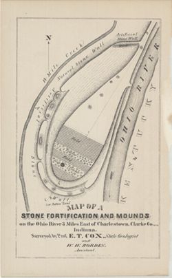
- Geographic Subject: Ohio River, Topical Subject: IGS Annual Reports, Topical Subject: Rivers, Topical Subject: Mounds, Topical Subject: Fortification, Geogra...
- Creator:
- Cox, E. T. (Edward Travers), 1821-1907 and Borden, W. W. (William Wesley), 1823-1906
- Publisher:
- Indiana. Geological Survey
- Date Created:
- 1873
- Identifier:
- VAC3073-M-01542
- Genre:
- Pictorial maps
- Geographic Location:
- Coordinates: W0853723 W0853635 N0382605 N0382513
- Related URL:
- Catalog URL: https://iucat.iu.edu/catalog/18318556
- Abstract:
- Surveyed by Prof. E. T. Cox and W. W. Borden. Pictorial map showing natural and artificial stone walls surrounding fields, timber, and mounds between the Ohi...
- Call Number:
- G4093.C4R4 1873 .C69
- Caption:
- Imprint: Indianapolis : Braden & Burford, Steam Lith., [1873] and Imprint: [Indianapolis] : [Geological Survey of Indiana], [1874]
- Physical Description:
- Dimensions: on sheet 22 x 14 cm and Scale: Scale not given.
- Alternate Identifier:
- Title Control Number: a18318556 and Alternate ID: 390723IP
- Persistent URL:
- https://purl.dlib.indiana.edu/iudl/images/VAC3073/VAC3073-M-01542
- Provenance:
- 5th Annual Report (1873) / Indiana. Geological Survey.
-
- Subject:
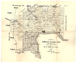
- Topical Subject: IGS Annual Reports, Topical Subject: Real property, Geographic Subject: Jefferson County (Ind.), and Topical Subject: Landowners
- Creator:
- Borden, W. W. (William Wesley), 1823-1906
- Publisher:
- Indiana. Geological Survey
- Date Created:
- 1875
- Identifier:
- VAC3073-M-01172
- Genre:
- Cadastral maps
- Geographic Location:
- Coordinates: W0853944 W0851048 N0385447 N0383436
- Related URL:
- Catalog URL: https://iucat.iu.edu/catalog/18318691
- Abstract:
- Prepared for the sixth annual report of E.T. Cox, State Geologist, geology by W.W. Borden. Relief shown by hachures. Shows cities and towns, railroads, and l...
- Call Number:
- G4093.J5C5 1874 .B6
- Caption:
- Imprint: [Indianapolis, Indiana] : [Sentinel Co., printers], [1875] and Imprint: [Indianapolis] : [Geological Survey of Indiana], [1875]
- Physical Description:
- Dimensions: 40 x 35 cm, on sheet 39 x 47 cm and Scale: Approximately 1:130,000
- Alternate Identifier:
- Alternate ID: 390723IP and Title Control Number: a18318691
- Persistent URL:
- https://purl.dlib.indiana.edu/iudl/images/VAC3073/VAC3073-M-01172
- Provenance:
- 6th Annual Report (1874) / Indiana. Geological Survey.
-
- Subject:
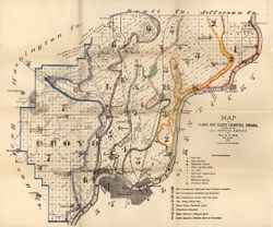
- Topical Subject: Geology, Geographic Subject: Clark County (Ind.), Topical Subject: Mines and mineral resources, Geographic Subject: Floyd County (Ind.), and...
- Creator:
- Cox, E. T. (Edward Travers), 1821-1907 and Borden, W. W. (William Wesley), 1823-1906
- Publisher:
- Indiana. Geological Survey
- Date Created:
- 1874
- Identifier:
- VAC3073-M-01155
- Genre:
- Geological maps
- Geographic Location:
- Coordinates: W0860258 W0852426 N0383636 N0380900
- Related URL:
- Catalog URL: https://iucat.iu.edu/catalog/18318611
- Abstract:
- Prepared for the 5th annual report of Prof. E.T. Cox, State Geologist, 1873 , geology by W.W. Borden. Relief shown by hachures. Shows cities and towns, railr...
- Call Number:
- G4093.C4C5 1873 .B6
- Caption:
- Imprint: [Indianapolis] : [Geological Survey of Indiana], [1874] and Imprint: [Indianapolis] : [Sentinel Co., printers], [1874]
- Physical Description:
- Dimensions: on sheet 41 x 49 cm and Scale: Approximately 1:130,000
- Alternate Identifier:
- Alternate ID: 390723IP and Title Control Number: a18318611
- Persistent URL:
- https://purl.dlib.indiana.edu/iudl/images/VAC3073/VAC3073-M-01155
- Provenance:
- 5th Annual Report (1873) / Indiana. Geological Survey.
-
- Subject:
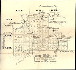
- Topical Subject: Landowners, Geographic Subject: Scott County (Ind.), Topical Subject: IGS Annual Reports, and Topical Subject: Real property
- Creator:
- Borden, W. W. (William Wesley), 1823-1906
- Publisher:
- Indiana. Geological Survey
- Date Created:
- 1875
- Identifier:
- VAC3073-M-01147
- Genre:
- Cadastral maps
- Geographic Location:
- Coordinates: W0855524 W0853733 N0385016 N0383454
- Related URL:
- Catalog URL: https://iucat.iu.edu/catalog/18318693
- Abstract:
- Prepared for the sixth annual report of E.T. Cox, State Geologist / geology by W.W. Borden, 1874. Relief shown by hachures. Shows cities and towns, railroads...
- Call Number:
- G4093.S3G46 1874 .B6
- Caption:
- Imprint: [Indianapolis] : [Geological Survey of Indiana], [1875] and Imprint: [Indianapolis, Indiana] : [Sentinel Co., printers], [1875]
- Physical Description:
- Scale: Approximately 1:130,000 and Dimensions: 31 x 30 cm, on sheet 38 x 35 cm
- Alternate Identifier:
- Alternate ID: 390723IP and Title Control Number: a18318693
- Persistent URL:
- https://purl.dlib.indiana.edu/iudl/images/VAC3073/VAC3073-M-01147
- Provenance:
- 6th Annual Report (1874) / Indiana. Geological Survey.
