
Search Constraints
You searched for:
Provenance
DMA Topographic Center, Army Map Service Library, OMAHA, Library of Congress Geography & Map Division
Remove constraint Provenance: DMA Topographic Center, Army Map Service Library, OMAHA, Library of Congress Geography & Map Division
Publisher
Главное управление геодезии и картографии при СНК СССР
Remove constraint Publisher: Главное управление геодезии и картографии при СНК СССР
1 - 79 of 79
Search Results
-
- Description:
- 1938
- Subject:
- Geographic Subject: Zhilotkovo, Topical Subject: Maps, and Topical Subject: Soviet Union
- Publisher:
- Главное управление геодезии и картографии при СНК СССР
- Language:
- Russian
- Date Created:
- 1941
- Identifier:
- VAC9619-003536
- Genre:
- Military Maps and Topographic Maps
- Geographic Location:
- Coordinates: 57.5, 34, 57.667, 34.25
- Related URL:
- Download GeoTIFF: https://drive.google.com/file/d/1Pe-aFLW2Qa6vUmm_dwALhMl2GYKWwbBC/view?usp=sharing and Catalog URL: http://iucat.iu.edu/catalog/5020131
- Abstract:
- Modern area represented: Жилотково (Zhilotkovo), Tverskaya oblast, Russia
- Call Number:
- GM G7000 s50 .S68 sheet O-36-93-A
- City:
- Жилотково (Zhilotkovo)
- Copyright Holder:
- No Copyright - United States
- Country:
- СССР (USSR)
- State/Province:
- Бологовский район (Bologovsky district), Вышневолоцкий район (Vyshnevolotsky district), and Калининская область (Kalinin oblast)
- Physical Description:
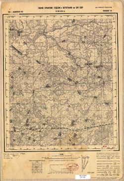
- Scale: 1:50,000
- Persistent URL:
- http://purl.dlib.indiana.edu/iudl/images/VAC9619/VAC9619-003536
- Provenance:
- DMA Topographic Center, Army Map Service Library, OMAHA, Library of Congress Geography & Map Division
-
- Description:
- 1939
- Subject:
- Topical Subject: Maps, Geographic Subject: Kostruble, and Topical Subject: Soviet Union
- Publisher:
- Главное управление геодезии и картографии при СНК СССР
- Language:
- Russian
- Date Created:
- 1941
- Identifier:
- VAC9619-003535
- Genre:
- Topographic Maps and Military Maps
- Geographic Location:
- Coordinates: 57.3333, 33.5, 57.5, 33.75
- Related URL:
- Catalog URL: http://iucat.iu.edu/catalog/5020131 and Download GeoTIFF: https://drive.google.com/file/d/1QDlMGkmv8VYRkMLbUljh11YMjbuAlbNM/view?usp=sharing
- Abstract:
- Modern area represented: Кострубле (Kostruble), Tverskaya oblast, Russia
- Call Number:
- GM G7000 s50 .S68 sheet O-36-92-C
- Caption:
- Для служебного пользования
- City:
- Каструбли (Kastrubli)
- Copyright Holder:
- No Copyright - United States
- Country:
- СССР (USSR)
- State/Province:
- Фировский район (Firovsky district), Калининская область (Kalinin oblast), and Осташковский район (Ostashkovsky district)
- Physical Description:
- Scale: 1:50,000
- Persistent URL:
- http://purl.dlib.indiana.edu/iudl/images/VAC9619/VAC9619-003535
- Provenance:
- DMA Topographic Center, Army Map Service Library, OMAHA, Library of Congress Geography & Map Division
-

- Description:
- 1938
- Subject:
- Geographic Subject: Nalyuchi, Topical Subject: Soviet Union, and Topical Subject: Maps
- Publisher:
- Главное управление геодезии и картографии при СНК СССР
- Language:
- Russian
- Date Created:
- 1940
- Identifier:
- VAC9619-003525
- Genre:
- Military Maps and Topographic Maps
- Geographic Location:
- Coordinates: 57.66667, 31.75, 57.83333, 32.0
- Related URL:
- Download GeoTIFF: https://drive.google.com/file/d/1sFselxWPujPodWUqJlqPIV8m91n3gL0P/view?usp=sharing and Catalog URL: http://iucat.iu.edu/catalog/5020131
- Abstract:
- Modern area represented: Налючи (Nalyuchi), Novgorodskaya oblast, Russia
- Call Number:
- GM G7000 s50 .S68 sheet O-36-76-D
- Caption:
- Для служебного пользования
- City:
- Налючи (Nalyuchi)
- Copyright Holder:
- No Copyright - United States
- Country:
- СССР (USSR)
- State/Province:
- Лычковский район (Lychkovsky district), Старорусский район (Starorussky district), Демянский район (Demyansky district), Ленинградская область (Leningrad obl...
- Physical Description:
- Scale: 1:50,000
- Persistent URL:
- http://purl.dlib.indiana.edu/iudl/images/VAC9619/VAC9619-003525
- Provenance:
- DMA Topographic Center, Army Map Service Library, OMAHA, Library of Congress Geography & Map Division
-
- Description:
- 1938
- Subject:
- Geographic Subject: Selikhovo, Topical Subject: Maps, and Topical Subject: Soviet Union
- Publisher:
- Главное управление геодезии и картографии при СНК СССР
- Language:
- Russian
- Date Created:
- 1941
- Identifier:
- VAC9619-003523
- Genre:
- Topographic Maps and Military Maps
- Geographic Location:
- Coordinates: 56.5, 36.75, 56.667, 37
- Related URL:
- Catalog URL: http://iucat.iu.edu/catalog/5020131 and Download GeoTIFF: https://drive.google.com/file/d/1rCotVjjaQLPnjUbK9attztcgGVRXarAQ/view?usp=sharing
- Abstract:
- Modern area represented: Селихово (Selikhovo), Tverskaya oblast, Russia
- Call Number:
- GM G7000 s50 .S68 sheet O-37-122-B
- City:
- Селехово (Selekhovo)
- Copyright Holder:
- No Copyright - United States
- Country:
- СССР (USSR)
- State/Province:
- Калининская область (Kalinin oblast), Клинский район (Klinsky district), Московская область (Moscow oblast), Конаковский район (Konakovsky district), and Зав...
- Physical Description:
- Scale: 1:50,000
- Persistent URL:
- http://purl.dlib.indiana.edu/iudl/images/VAC9619/VAC9619-003523
- Provenance:
- DMA Topographic Center, Army Map Service Library, OMAHA, Library of Congress Geography & Map Division
-
- Description:
- 1938
- Subject:
- Topical Subject: Maps, Topical Subject: Soviet Union, and Geographic Subject: Sloboda
- Publisher:
- Главное управление геодезии и картографии при СНК СССР
- Language:
- Russian
- Date Created:
- 1941
- Identifier:
- VAC9619-003514
- Genre:
- Topographic Maps and Military Maps
- Geographic Location:
- Coordinates: 56.333, 36.75, 56.5, 37
- Related URL:
- Download GeoTIFF: https://drive.google.com/file/d/1FIM5aUANKvW41Va_K16TJ3TTeA1rgXmo/view?usp=sharing and Catalog URL: http://iucat.iu.edu/catalog/5020131
- Abstract:
- Modern area represented: Sloboda, Russia
- Call Number:
- GM G7000 s50 .S68 sheet O-37-122-D
- City:
- Слобода (Sloboda)
- Copyright Holder:
- No Copyright - United States
- Country:
- СССР (USSR)
- State/Province:
- Солнечногорский район (Solnechnogorsky district), Клинский район (Klinsky district), and Московская область (Moscow oblast)
- Physical Description:
- Scale: 1:50,000
- Persistent URL:
- http://purl.dlib.indiana.edu/iudl/images/VAC9619/VAC9619-003514
- Provenance:
- DMA Topographic Center, Army Map Service Library, OMAHA, Library of Congress Geography & Map Division
-

- Description:
- 1939
- Subject:
- Geographic Subject: Gorodkovo, Topical Subject: Soviet Union, and Topical Subject: Maps
- Publisher:
- Главное управление геодезии и картографии при СНК СССР
- Language:
- Russian
- Date Created:
- 1941
- Identifier:
- VAC9619-003512
- Genre:
- Topographic Maps and Military Maps
- Geographic Location:
- Coordinates: 56.0, 35.25, 56.16667, 35.5
- Related URL:
- Download GeoTIFF: https://drive.google.com/file/d/1Ac04NnRe-NzKr_Rd_4abwOlEUVYMcFWL/view?usp=sharing and Catalog URL: http://iucat.iu.edu/catalog/5020131
- Abstract:
- Modern area represented: Городково (Gorodkovo), Moscow oblast, Russia
- Call Number:
- GM G7000 s50 .S68 sheet O-36-143-D
- City:
- Городково (Gorodkovo)
- Copyright Holder:
- No Copyright - United States
- Country:
- СССР (USSR)
- State/Province:
- Шаховской район (Shakhovsky district), Калининская область (Kalinin oblast), Московская область (Moscow oblast), and Погорельский район (Pogorelsky district)
- Physical Description:
- Scale: 1:50,000
- Persistent URL:
- http://purl.dlib.indiana.edu/iudl/images/VAC9619/VAC9619-003512
- Provenance:
- DMA Topographic Center, Army Map Service Library, OMAHA, Library of Congress Geography & Map Division
-
- Description:
- 1939
- Subject:
- Topical Subject: Maps, Topical Subject: Soviet Union, and Geographic Subject: Mozzharino
- Publisher:
- Главное управление геодезии и картографии при СНК СССР
- Language:
- Russian
- Date Created:
- 1941
- Identifier:
- VAC9619-003509
- Genre:
- Topographic Maps and Military Maps
- Geographic Location:
- Coordinates: 56, 34.5, 56.167, 34.75
- Related URL:
- Download GeoTIFF: https://drive.google.com/file/d/1c7-Ks0v5sWqFD0L20fR-lFQ0zbJh_jnU/view?usp=sharing and Catalog URL: http://iucat.iu.edu/catalog/5020131
- Abstract:
- Modern area represented: part of Зубцов (Zubtsov), Tverskaya oblast, Russia
- Call Number:
- GM G7000 s50 .S68 sheet O-36-142-C
- City:
- Мозжарино (Mozzharino)
- Copyright Holder:
- No Copyright - United States
- Country:
- СССР (USSR)
- State/Province:
- РСФСР (RSFSR) and Калининская область (Kalinin oblast)
- Physical Description:
- Scale: 1:50,000
- Persistent URL:
- http://purl.dlib.indiana.edu/iudl/images/VAC9619/VAC9619-003509
- Provenance:
- DMA Topographic Center, Army Map Service Library, OMAHA, Library of Congress Geography & Map Division
-
- Description:
- 1939
- Subject:
- Topical Subject: Maps, Topical Subject: Soviet Union, and Geographic Subject: Nikiforovskoye
- Publisher:
- Главное управление геодезии и картографии при СНК СССР
- Language:
- Russian
- Date Created:
- 1941
- Identifier:
- VAC9619-003508
- Genre:
- Military Maps and Topographic Maps
- Geographic Location:
- Coordinates: 56.167, 34.75, 56.333, 35
- Related URL:
- Catalog URL: http://iucat.iu.edu/catalog/5020131 and Download GeoTIFF: https://drive.google.com/file/d/14gDli5M_EfZMq68zOWwoAldVf4cw81U9/view?usp=sharing
- Abstract:
- Modern area represented: Никифоровское (Nikiforovskoye), Tverskaya oblast, Russia
- Call Number:
- GM G7000 s50 .S68 sheet O-36-142-B
- City:
- Никифоровское (Nikiforovskoye)
- Copyright Holder:
- No Copyright - United States
- Country:
- СССР (USSR)
- State/Province:
- Калининская область (Kalinin oblast), Погорельский район (Pogorelsky district), Зубцовский район (Zubtsovsky district), and Старицкий район (Staritsky district)
- Physical Description:
- Scale: 1:50,000
- Persistent URL:
- http://purl.dlib.indiana.edu/iudl/images/VAC9619/VAC9619-003508
- Provenance:
- DMA Topographic Center, Army Map Service Library, OMAHA, Library of Congress Geography & Map Division
-
- Description:
- 1939
- Subject:
- Geographic Subject: Sady, Topical Subject: Maps, and Topical Subject: Soviet Union
- Publisher:
- Главное управление геодезии и картографии при СНК СССР
- Language:
- Russian
- Date Created:
- 1941
- Identifier:
- VAC9619-003505
- Genre:
- Military Maps and Topographic Maps
- Geographic Location:
- Coordinates: 56.167, 33.5, 56.333, 33.75
- Related URL:
- Download GeoTIFF: https://drive.google.com/file/d/1fm8wOb5L79SO_B23TV6HYKZHDDp9tWLv/view?usp=sharing and Catalog URL: http://iucat.iu.edu/catalog/5020131
- Abstract:
- Modern area represented: Сады (Sady), Tverskaya oblast, Russia
- Call Number:
- GM G7000 s50 .S68 sheet O-36-140-A
- Caption:
- Captured map
- City:
- Сады (Sady)
- Copyright Holder:
- No Copyright - United States
- Country:
- СССР (USSR)
- State/Province:
- Оленинский район (Oleninsky district), Калининская область (Kalinin oblast), and Молодотудский район (Molodotudsky district)
- Physical Description:
- Scale: 1:50,000
- Persistent URL:
- http://purl.dlib.indiana.edu/iudl/images/VAC9619/VAC9619-003505
- Provenance:
- DMA Topographic Center, Army Map Service Library, OMAHA, Library of Congress Geography & Map Division
-
- Description:
- 1939
- Subject:
- Geographic Subject: Olenino, Topical Subject: Maps, and Topical Subject: Soviet Union
- Publisher:
- Главное управление геодезии и картографии при СНК СССР
- Language:
- Russian
- Date Created:
- 1941
- Identifier:
- VAC9619-003503
- Genre:
- Military Maps and Topographic Maps
- Geographic Location:
- Coordinates: 56.167, 33.25, 56.333, 33.5
- Related URL:
- Download GeoTIFF: https://drive.google.com/file/d/14VfwnsGlRiwDLRroFLvT-YtlQlOdMpvz/view?usp=sharing and Catalog URL: http://iucat.iu.edu/catalog/5020131
- Abstract:
- Modern area represented: Оленино (Olenino), Tverskaya oblast, Russia
- Call Number:
- GM G7000 s50 .S68 sheet O-36-139-B
- City:
- Оленино (Olenino)
- Copyright Holder:
- No Copyright - United States
- Country:
- СССР (USSR)
- State/Province:
- Оленинский район (Oleninsky district) and Калининская область (Kalinin oblast)
- Physical Description:
- Scale: 1:50,000
- Persistent URL:
- http://purl.dlib.indiana.edu/iudl/images/VAC9619/VAC9619-003503
- Provenance:
- DMA Topographic Center, Army Map Service Library, OMAHA, Library of Congress Geography & Map Division
-
- Description:
- 1938
- Subject:
- Geographic Subject: Rodnya, Topical Subject: Soviet Union, and Topical Subject: Maps
- Publisher:
- Главное управление геодезии и картографии при СНК СССР
- Language:
- Russian
- Date Created:
- 1941
- Identifier:
- VAC9619-003477
- Genre:
- Military Maps and Topographic Maps
- Geographic Location:
- Coordinates: 56.333, 34.75, 56.5, 35
- Related URL:
- Catalog URL: http://iucat.iu.edu/catalog/5020131 and Download GeoTIFF: https://drive.google.com/file/d/1REcEYzS-IqtvOX9vkRyhRwVimhCOaQL-/view?usp=sharing
- Abstract:
- Modern area represented: Родня (Rodnya), Tverskaya oblast, Russia
- Call Number:
- G7000 s50 .S68 sheet O-36-130-D
- City:
- Родня (Rodnya)
- Copyright Holder:
- No Copyright - United States
- Country:
- СССР (USSR)
- State/Province:
- Калининская область (Kalinin oblast), Старицкий район (Staritsky district), and Зубцовский район (Zubtsovsky district)
- Physical Description:
- Scale: 1:50,000
- Persistent URL:
- http://purl.dlib.indiana.edu/iudl/images/VAC9619/VAC9619-003477
- Provenance:
- DMA Topographic Center, Army Map Service Library, OMAHA, Library of Congress Geography & Map Division
-
- Description:
- 1938
- Subject:
- Topical Subject: Soviet Union, Geographic Subject: Staritsa, and Topical Subject: Maps
- Publisher:
- Главное управление геодезии и картографии при СНК СССР
- Language:
- Russian
- Date Created:
- 1941
- Identifier:
- VAC9619-003476
- Genre:
- Topographic Maps and Military Maps
- Geographic Location:
- Coordinates: 56.5, 34.75, 56.667, 35
- Related URL:
- Download GeoTIFF: https://drive.google.com/file/d/1Ffo_UO7HIdQS1iN83jJIlQTlyLKvURbA/view?usp=sharing and Catalog URL: http://iucat.iu.edu/catalog/5020131
- Abstract:
- Modern area represented: Старица (Staritsa), Tverskaya oblast, Russia
- Call Number:
- G7000 s50 .S68 sheet O-36-130-B
- City:
- Старица (Staritsa)
- Copyright Holder:
- No Copyright - United States
- Country:
- СССР (USSR)
- State/Province:
- Высоковский район (Vysokovsky district), Калининская область (Kalinin oblast), and Старицкий район (Staritsky district)
- Physical Description:
- Scale: 1:50,000
- Persistent URL:
- http://purl.dlib.indiana.edu/iudl/images/VAC9619/VAC9619-003476
- Provenance:
- DMA Topographic Center, Army Map Service Library, OMAHA, Library of Congress Geography & Map Division
-
- Description:
- 1938
- Subject:
- Topical Subject: Maps, Geographic Subject: Plotnikovo, and Topical Subject: Soviet Union
- Publisher:
- Главное управление геодезии и картографии при СНК СССР
- Language:
- Russian
- Date Created:
- 1941
- Identifier:
- VAC9619-003474
- Genre:
- Military Maps and Topographic Maps
- Geographic Location:
- Coordinates: 56.333, 34.25, 56.5, 34.5
- Related URL:
- Catalog URL: http://iucat.iu.edu/catalog/5020131 and Download GeoTIFF: https://drive.google.com/file/d/1rtSI05x2OGdyNyY9GkpIk8olI5V_zoPE/view?usp=sharing
- Abstract:
- Modern area represented: Плотниково (Plotnikovo), Tverskaya oblast, Russia
- Call Number:
- G7000 s50 .S68 sheet O-36-129-D
- City:
- Плотниково (Plotnikovo)
- Copyright Holder:
- No Copyright - United States
- Country:
- СССР (USSR)
- State/Province:
- Ржевский район (Rzhevsky district), Калининская область (Kalinin oblast), and Луковниковский район (Lukovnikovsky district)
- Physical Description:
- Scale: 1:50,000
- Persistent URL:
- http://purl.dlib.indiana.edu/iudl/images/VAC9619/VAC9619-003474
- Provenance:
- DMA Topographic Center, Army Map Service Library, OMAHA, Library of Congress Geography & Map Division
-

- Description:
- 1938
- Subject:
- Geographic Subject: Ramen'ye, Topical Subject: Soviet Union, and Topical Subject: Maps
- Publisher:
- Главное управление геодезии и картографии при СНК СССР
- Language:
- Russian
- Date Created:
- 1941
- Identifier:
- VAC9619-003473
- Genre:
- Topographic Maps and Military Maps
- Geographic Location:
- Coordinates: 56.333, 34, 56.5, 34.25
- Related URL:
- Download GeoTIFF: https://drive.google.com/file/d/1qh-E-lgJptpwG6nUxUBiR_gBwnFCrbrW/view?usp=sharing and Catalog URL: http://iucat.iu.edu/catalog/5020131
- Abstract:
- Modern area represented: Раменье (Ramen'ye), Tverskaya oblast, Russia
- Call Number:
- G7000 s50 .S68 sheet O-36-129-C
- City:
- Раменье (Ramen'ye)
- Copyright Holder:
- No Copyright - United States
- Country:
- СССР (USSR)
- State/Province:
- Луковниковский район (Lukovnikovsky district), Калининская область (Kalinin oblast), Молодотудский район (Molodotudsky district), and Ржевский район (Rzhevsk...
- Physical Description:
- Scale: 1:50,000
- Persistent URL:
- http://purl.dlib.indiana.edu/iudl/images/VAC9619/VAC9619-003473
- Provenance:
- DMA Topographic Center, Army Map Service Library, OMAHA, Library of Congress Geography & Map Division
-
- Description:
- 1939
- Subject:
- Geographic Subject: Okovtsy, Topical Subject: Maps, and Topical Subject: Soviet Union
- Publisher:
- Главное управление геодезии и картографии при СНК СССР
- Language:
- Russian
- Date Created:
- 1941
- Identifier:
- VAC9619-003471
- Genre:
- Topographic Maps and Military Maps
- Geographic Location:
- Coordinates: 56.5, 33.25, 56.667, 33.5
- Related URL:
- Download GeoTIFF: https://drive.google.com/file/d/1QrCmf9strde4Q_XXo1Oe5tCoJFq2VFP6/view?usp=sharing and Catalog URL: http://iucat.iu.edu/catalog/5020131
- Abstract:
- Modern area represented: Оковцы (Okovtsy), Tverskaya oblast, Russia
- Call Number:
- G7000 s50 .S68 sheet O-36-127-B
- City:
- Оковцы (Okovtsy)
- Copyright Holder:
- No Copyright - United States
- Country:
- СССР (USSR)
- State/Province:
- Кировский район (Kirov district), Молодотудский район (Molodotudsky district), and Калининская область (Kalinin oblast)
- Physical Description:
- Scale: 1:50,000
- Persistent URL:
- http://purl.dlib.indiana.edu/iudl/images/VAC9619/VAC9619-003471
- Provenance:
- DMA Topographic Center, Army Map Service Library, OMAHA, Library of Congress Geography & Map Division
-
- Description:
- 1939
- Subject:
- Topical Subject: Soviet Union, Geographic Subject: Vysokoye, and Topical Subject: Maps
- Publisher:
- Главное управление геодезии и картографии при СНК СССР
- Language:
- Russian
- Date Created:
- 1941
- Identifier:
- VAC9619-003470
- Genre:
- Topographic Maps and Military Maps
- Geographic Location:
- Coordinates: 56.333, 32.75, 56.5, 33
- Related URL:
- Download GeoTIFF: https://drive.google.com/file/d/12E5i-f2khtKqePPSxPnAOJT4oAAmYPRD/view?usp=sharing and Catalog URL: http://iucat.iu.edu/catalog/5020131
- Abstract:
- Modern area represented: Высокое (Vysokoye), Tverskaya oblast, Russia
- Call Number:
- G7000 s50 .S68 sheet O-36-126-D
- City:
- Высокое (Vysokoye)
- Copyright Holder:
- No Copyright - United States
- Country:
- СССР (USSR)
- State/Province:
- Нелидовский район (Nelidovsky district), Ленинский район (Leninsky district), Молодотудский район (Molodotudsky district), and Калининская область (Kalinin o...
- Physical Description:
- Scale: 1:50,000
- Persistent URL:
- http://purl.dlib.indiana.edu/iudl/images/VAC9619/VAC9619-003470
- Provenance:
- DMA Topographic Center, Army Map Service Library, OMAHA, Library of Congress Geography & Map Division
-
- Description:
- 1939
- Subject:
- Geographic Subject: Mozhayevo, Topical Subject: Soviet Union, and Topical Subject: Maps
- Publisher:
- Главное управление геодезии и картографии при СНК СССР
- Language:
- Russian
- Date Created:
- 1941
- Identifier:
- VAC9619-003467
- Genre:
- Military Maps and Topographic Maps
- Geographic Location:
- Coordinates: 56.5, 32.5, 56.667, 32.75
- Related URL:
- Download GeoTIFF: https://drive.google.com/file/d/1DmpxDqo31t3uRO5WexL_6pIauKcw7TJS/view?usp=sharing and Catalog URL: http://iucat.iu.edu/catalog/5020131
- Abstract:
- Modern area represented: Можаево (Mozhayevo), Tverskaya oblast, Russia
- Call Number:
- G7000 s50 .S68 sheet O-36-126-A
- City:
- Можаево (Mozhayevo)
- Copyright Holder:
- No Copyright - United States
- Country:
- СССР (USSR)
- State/Province:
- Нелидовский район (Nelidovsky district), Пеновский район (Penovsky district), Ленинский район (Leninsky district), and Калининская область (Kalinin oblast)
- Physical Description:
- Scale: 1:50,000
- Persistent URL:
- http://purl.dlib.indiana.edu/iudl/images/VAC9619/VAC9619-003467
- Provenance:
- DMA Topographic Center, Army Map Service Library, OMAHA, Library of Congress Geography & Map Division
-
- Description:
- 1939
- Subject:
- Topical Subject: Maps, Geographic Subject: Luk’yanovo, and Topical Subject: Soviet Union
- Publisher:
- Главное управление геодезии и картографии при СНК СССР
- Language:
- Russian
- Date Created:
- 1941
- Identifier:
- VAC9619-003466
- Genre:
- Military Maps and Topographic Maps
- Geographic Location:
- Coordinates: 56.333, 31.75, 56.5, 32
- Related URL:
- Catalog URL: http://iucat.iu.edu/catalog/5020131 and Download GeoTIFF: https://drive.google.com/file/d/10v1q0TE_qhlBpBnUD4qgXMRlbV163Z0k/view?usp=sharing
- Abstract:
- Modern area represented: Лукьяново (Luk’yanovo), Tverskaya oblast, Russia
- Call Number:
- GM G7000 s50 .S68 sheet O-36-124-D
- City:
- Лукьяново (Luk’yanovo)
- Copyright Holder:
- No Copyright - United States
- Country:
- СССР (USSR)
- State/Province:
- Октябрьский район (Oktyabrsky district), Ленинский район (Leninsky district), Торопецкий район (Toropetsky district), and Калининская область (Kalinin oblast)
- Physical Description:
- Scale: 1:50,000
- Persistent URL:
- http://purl.dlib.indiana.edu/iudl/images/VAC9619/VAC9619-003466
- Provenance:
- DMA Topographic Center, Army Map Service Library, OMAHA, Library of Congress Geography & Map Division
-
- Description:
- 1939
- Subject:
- Geographic Subject: Toropets, Topical Subject: Soviet Union, and Topical Subject: Maps
- Publisher:
- Главное управление геодезии и картографии при СНК СССР
- Language:
- Russian
- Identifier:
- VAC9619-003463
- Genre:
- Topographic Maps and Military Maps
- Geographic Location:
- Coordinates: 56.5, 31.5, 56.667, 31.75
- Related URL:
- Download GeoTIFF: https://drive.google.com/file/d/1EASaF8lo6_Fq32YArRd9sCaBlurPVfbV/view?usp=sharing and Catalog URL: http://iucat.iu.edu/catalog/5020131
- Abstract:
- Modern area represented: Торопец (Toropets), Tverskaya oblast, Russia
- Call Number:
- GM G7000 s50 .S68 sheet O-36-124-A
- Caption:
- Для служебного пользования
- City:
- Торопец (Toropets)
- Copyright Holder:
- No Copyright - United States
- Country:
- СССР (USSR)
- State/Province:
- РСФСР (RSFSR) and Калининская область (Kalinin oblast)
- Physical Description:
- Scale: 1:50,000
- Persistent URL:
- http://purl.dlib.indiana.edu/iudl/images/VAC9619/VAC9619-003463
- Provenance:
- DMA Topographic Center, Army Map Service Library, OMAHA, Library of Congress Geography & Map Division
-
- Description:
- 1939
- Subject:
- Geographic Subject: Druzhnaya Gorka, Topical Subject: Maps, and Topical Subject: Soviet Union
- Publisher:
- Главное управление геодезии и картографии при СНК СССР
- Language:
- Russian
- Identifier:
- VAC9619-003376
- Genre:
- Topographic Maps and Military Maps
- Geographic Location:
- Coordinates: 58.333, 32.75, 58.5, 33
- Related URL:
- Catalog URL: http://iucat.iu.edu/catalog/5020131 and Download GeoTIFF: https://drive.google.com/file/d/1oGUheQvOXuuLP8IOCN-VUvVMS9T4NRqK/view?usp=sharing
- Abstract:
- Modern area represented: Дружная Горка (Druzhnaya Gorka), Novgorodskaya oblast, Russia
- Call Number:
- G7000 s50 .S68 sheet O-36-54-D
- Caption:
- Для служебного пользования
- City:
- Glupaya Gorka
- Copyright Holder:
- No Copyright - United States
- Country:
- СССР (USSR)
- State/Province:
- Ленинградская область (Leningrad oblast), Окуловский район (Okulovsky district), and Крестецкий район (Krestetsky district)
- Physical Description:
- Scale: 1:50,000
- Persistent URL:
- http://purl.dlib.indiana.edu/iudl/images/VAC9619/VAC9619-003376
- Provenance:
- DMA Topographic Center, Army Map Service Library, OMAHA, Library of Congress Geography & Map Division
-
- Description:
- 1939
- Subject:
- Topical Subject: Maps, Geographic Subject: Torbino, and Topical Subject: Soviet Union
- Publisher:
- Главное управление геодезии и картографии при СНК СССР
- Language:
- Russian
- Date Created:
- 1941
- Identifier:
- VAC9619-003374
- Genre:
- Military Maps and Topographic Maps
- Geographic Location:
- Coordinates: 58.5, 32.75, 58.667, 33
- Related URL:
- Download GeoTIFF: https://drive.google.com/file/d/1REcpv4d51hjjI3DlbpCjUEu2PCsUgHsu/view?usp=sharing and Catalog URL: http://iucat.iu.edu/catalog/5020131
- Abstract:
- Modern area represented: Торбино (Torbino), Novgorodskaya oblast, Russia
- Call Number:
- G7000 s50 .S68 sheet O-36-54-B
- Caption:
- Для служебного пользования and Captured map
- City:
- Торбино (Torbino)
- Copyright Holder:
- No Copyright - United States
- Country:
- СССР (USSR)
- State/Province:
- Ленинградская область (Leningrad oblast)
- Physical Description:
- Scale: 1:50,000
- Persistent URL:
- http://purl.dlib.indiana.edu/iudl/images/VAC9619/VAC9619-003374
- Provenance:
- DMA Topographic Center, Army Map Service Library, OMAHA, Library of Congress Geography & Map Division
-
- Description:
- 1937
- Subject:
- Topical Subject: Soviet Union, Geographic Subject: Lyubolyady, and Topical Subject: Maps
- Publisher:
- Главное управление геодезии и картографии при СНК СССР
- Language:
- Russian
- Date Created:
- 1941
- Identifier:
- VAC9619-003363
- Genre:
- Military Maps and Topographic Maps
- Geographic Location:
- Coordinates: 58.5, 30.75, 58.667, 31
- Related URL:
- Catalog URL: http://iucat.iu.edu/catalog/5020131 and Download GeoTIFF: https://drive.google.com/file/d/1ZDggAdZ_3laR_snLCNc-7jxa2T1MoShO/view?usp=sharing
- Abstract:
- Modern area represented: Люболяды (Lyubolyady), Novgorodskaya oblast, Russia
- Call Number:
- G7000 s50 .S68 sheet O-36-50-B
- Caption:
- Для служебного пользования and Captured map
- City:
- Люболяды (Lyubolyady)
- Copyright Holder:
- No Copyright - United States
- Country:
- СССР (USSR)
- State/Province:
- Новгородский район (Novgorod district), Ленинградская область (Leningrad oblast), РСФСР (RSFSR), and Батецкий район (Batetsky district)
- Physical Description:
- Scale: 1:50,000
- Persistent URL:
- http://purl.dlib.indiana.edu/iudl/images/VAC9619/VAC9619-003363
- Provenance:
- DMA Topographic Center, Army Map Service Library, OMAHA, Library of Congress Geography & Map Division
-
- Description:
- 1938
- Subject:
- Geographic Subject: Kashira, Topical Subject: Maps, and Topical Subject: Soviet Union
- Publisher:
- Главное управление геодезии и картографии при СНК СССР
- Language:
- Russian
- Date Created:
- 1941
- Identifier:
- VAC9619-003101
- Genre:
- Military Maps and Topographic Maps
- Geographic Location:
- Coordinates: 54.667, 38, 55, 38.5
- Related URL:
- Download GeoTIFF: https://drive.google.com/file/d/1yvi6zIZ_VbmjGBIIf9ja_bK-q6bKmhM7/view?usp=sharing and Catalog URL: https://iucat.iu.edu/catalog/5020129
- Abstract:
- Modern area represented: Kashira, Russia
- Call Number:
- G7000 s100 .S7 sheet N-37-41
- Caption:
- Для служебного пользования
- City:
- Кашира (Kashira)
- Copyright Holder:
- No Copyright - United States
- Country:
- СССР (USSR)
- State/Province:
- РСФСР (RSFSR), Тульская область (Tula oblast), and Московская область (Moscow oblast)
- Physical Description:
- Scale: 1:100,000
- Persistent URL:
- http://purl.dlib.indiana.edu/iudl/images/VAC9619/VAC9619-003101
- Provenance:
- DMA Topographic Center, Army Map Service Library, OMAHA, Library of Congress Geography & Map Division
-
- Description:
- 1939
- Subject:
- Geographic Subject: Venev, Topical Subject: Maps, and Topical Subject: Soviet Union
- Publisher:
- Главное управление геодезии и картографии при СНК СССР
- Language:
- Russian
- Date Created:
- 1941
- Identifier:
- VAC9619-003127
- Genre:
- Military Maps and Topographic Maps
- Geographic Location:
- Coordinates: 54.333, 38, 54.667, 38.5
- Related URL:
- Catalog URL: https://iucat.iu.edu/catalog/5020129 and Download GeoTIFF: https://drive.google.com/file/d/1huo8223fKmqHNHQ73Boeu97sA0Aj_YEb/view?usp=sharing
- Abstract:
- Modern area represented: Венев (Venev), Tulskaya oblast, Russia
- Call Number:
- G7000 s100 .S7 sheet N-37-53
- Caption:
- Для cлужебного пользования
- City:
- Венев (Venev)
- Copyright Holder:
- No Copyright - United States
- Country:
- СССР (USSR)
- State/Province:
- Тульская область (Tula oblast), РСФСР (RSFSR), and Московская область (Moscow oblast)
- Physical Description:
- Scale: 1:100,000
- Persistent URL:
- http://purl.dlib.indiana.edu/iudl/images/VAC9619/VAC9619-003127
- Provenance:
- DMA Topographic Center, Army Map Service Library, OMAHA, Library of Congress Geography & Map Division
-
- Description:
- 1938
- Subject:
- Geographic Subject: Serebryanyye Prudy, Topical Subject: Maps, and Topical Subject: Soviet Union
- Publisher:
- Главное управление геодезии и картографии при СНК СССР
- Language:
- Russian
- Date Created:
- 1941
- Identifier:
- VAC9619-003128
- Genre:
- Military Maps and Topographic Maps
- Geographic Location:
- Coordinates: 54.333, 38.5, 54.667, 39
- Related URL:
- Catalog URL: https://iucat.iu.edu/catalog/5020129 and Download GeoTIFF: https://drive.google.com/file/d/1YYx26VaS76GQI3hdjQEJ52cI5zkvnP0F/view?usp=sharing
- Abstract:
- Modern area represented: Serebryanyye Prudy, Russia
- Call Number:
- G7000 s100 .S7 sheet N-37-54
- Caption:
- Для служебного пользования,Captured map
- City:
- Серебряные Пруды (Serebryanyye Prudy)
- Copyright Holder:
- No Copyright - United States
- Country:
- СССР (USSR)
- State/Province:
- Московская область (Moscow oblast), Тульская область (Tula oblast), and Рязанская область (Ryazan oblast)
- Physical Description:
- Scale: 1:100,000
- Persistent URL:
- http://purl.dlib.indiana.edu/iudl/images/VAC9619/VAC9619-003128
- Provenance:
- DMA Topographic Center, Army Map Service Library, OMAHA, Library of Congress Geography & Map Division
-
- Description:
- 1939
- Subject:
- Topical Subject: Soviet Union, Geographic Subject: Yepifan, and Topical Subject: Maps
- Publisher:
- Главное управление геодезии и картографии при СНК СССР
- Language:
- Russian
- Date Created:
- 1941
- Identifier:
- VAC9619-003143
- Genre:
- Topographic Maps and Military Maps
- Geographic Location:
- Coordinates: 53.667, 38.5, 54, 39
- Related URL:
- Download GeoTIFF: https://drive.google.com/file/d/1_opuachralOhQCpnGblLxk3DH719prZ7/view?usp=sharing and Catalog URL: https://iucat.iu.edu/catalog/5020129
- Abstract:
- Modern area represented: Yepifan, Russia
- Call Number:
- G7000 s100 .S7 sheet N-37-78
- City:
- Епифань (Yepifan)
- Copyright Holder:
- No Copyright - United States
- Country:
- СССР (USSR)
- State/Province:
- Чапаевский район (Chapayevsky district), Чернавский район (Chernavsky district), Кимовский район (Kimovsky district), Горловский район (Gorlovsky district), ...
- Physical Description:
- Scale: 1:100,000
- Persistent URL:
- http://purl.dlib.indiana.edu/iudl/images/VAC9619/VAC9619-003143
- Provenance:
- DMA Topographic Center, Army Map Service Library, OMAHA, Library of Congress Geography & Map Division
-
- Description:
- 1939
- Subject:
- Topical Subject: Soviet Union, Geographic Subject: ostrov Karedzhi, and Topical Subject: Maps
- Publisher:
- Главное управление геодезии и картографии при СНК СССР
- Language:
- Russian
- Date Created:
- 1941
- Identifier:
- VAC9619-002952
- Genre:
- Military Maps and Topographic Maps
- Geographic Location:
- Coordinates: 60, 31.25, 60.167, 31.5
- Related URL:
- Catalog URL: http://iucat.iu.edu/catalog/5020131 and Download GeoTIFF: https://drive.google.com/file/d/1VwB1YlJ8nRbE3bZAbWP7nSesMwmFUrRU/view?usp=sharing
- Abstract:
- Modern area represented: остров Кареджи (ostrov Karedzhi)
- Call Number:
- GM G7000 s50 .S68 sheet P-36-135-D
- Caption:
- Для служебного пользования
- City:
- остров Кареджский (ostrov Karedzhskiy)
- Copyright Holder:
- No Copyright - United States
- Country:
- СССР (USSR)
- State/Province:
- Ленинградская область (Leningrad oblast), РСФСР (RSFSR), and Мгинский район (Mginsky district)
- Physical Description:
- Scale: 1:50,000
- Persistent URL:
- http://purl.dlib.indiana.edu/iudl/images/VAC9619/VAC9619-002952
- Provenance:
- DMA Topographic Center, Army Map Service Library, OMAHA, Library of Congress Geography & Map Division
-
- Description:
- 1939
- Subject:
- Geographic Subject: Kivgoda, Topical Subject: Soviet Union, and Topical Subject: Maps
- Publisher:
- Главное управление геодезии и картографии при СНК СССР
- Language:
- Russian
- Date Created:
- 1941
- Identifier:
- VAC9619-002953
- Genre:
- Military Maps and Topographic Maps
- Geographic Location:
- Coordinates: 60.167, 31.5, 60.333, 31.75
- Related URL:
- Catalog URL: http://iucat.iu.edu/catalog/5020131 and Download GeoTIFF: https://drive.google.com/file/d/1-NTMMBhpjvV0-U9w20hI8f4U0XiFpXDC/view?usp=sharing
- Abstract:
- Modern area represented: Kivgoda, Leningrad oblast, Russia
- Call Number:
- GM G7000 s50 .S68 sheet P-36-136-A
- Caption:
- Для служебного пользования
- City:
- Кивгода (Kivgoda)
- Copyright Holder:
- No Copyright - United States
- Country:
- СССР (USSR)
- State/Province:
- Ленинградская область (Leningrad oblast), Мгинский район (Mginsky district), РСФСР (RSFSR), and Волховский район (Volkhov district)
- Physical Description:
- Scale: 1:50,000
- Persistent URL:
- http://purl.dlib.indiana.edu/iudl/images/VAC9619/VAC9619-002953
- Provenance:
- DMA Topographic Center, Army Map Service Library, OMAHA, Library of Congress Geography & Map Division
-
- Description:
- 1939
- Subject:
- Topical Subject: Soviet Union, Topical Subject: Maps, and Geographic Subject: Dubno
- Publisher:
- Главное управление геодезии и картографии при СНК СССР
- Language:
- Russian
- Date Created:
- 1941
- Identifier:
- VAC9619-002955
- Genre:
- Topographic Maps and Military Maps
- Geographic Location:
- Coordinates: 60.16667, 31.75, 60.3333, 32.0
- Related URL:
- Download GeoTIFF: https://drive.google.com/file/d/1uIZ1zrQmo44Nz8EzHTws5XvPlG2YxEEn/view?usp=sharing and Catalog URL: http://iucat.iu.edu/catalog/5020131
- Abstract:
- Modern area represented: Dubno, Russia
- Call Number:
- GM G7000 s50 .S68 sheet P-36-136-B
- Caption:
- Для служебного пользования
- City:
- Дубно (Dubno)
- Copyright Holder:
- No Copyright - United States
- Country:
- СССР (USSR)
- State/Province:
- Волховский район (Volkhov district), Ленинградская область (Leningrad oblast), Мгинский район (Mginsky district), and РСФСР (RSFSR)
- Physical Description:
- Scale: 1:50,000
- Persistent URL:
- http://purl.dlib.indiana.edu/iudl/images/VAC9619/VAC9619-002955
- Provenance:
- DMA Topographic Center, Army Map Service Library, OMAHA, Library of Congress Geography & Map Division
-
- Description:
- 1939
- Subject:
- Topical Subject: Soviet Union, Topical Subject: Maps, and Geographic Subject: Ostrov
- Publisher:
- Главное управление геодезии и картографии при СНК СССР
- Language:
- Russian
- Date Created:
- 1941
- Identifier:
- VAC9619-002957
- Genre:
- Military Maps and Topographic Maps
- Geographic Location:
- Coordinates: 60, 31.75, 60.167, 32
- Related URL:
- Catalog URL: http://iucat.iu.edu/catalog/5020131 and Download GeoTIFF: https://drive.google.com/file/d/17pBS93leK5HdBIyVCAHPECmK_QwD68KD/view?usp=sharing
- Abstract:
- Modern area represented: Ostrov, Russia
- Call Number:
- GM G7000 s50 .S68 sheet P-36-136-D
- Caption:
- Для служебного пользования
- City:
- Остров (Ostrov)
- Copyright Holder:
- No Copyright - United States
- Country:
- СССР (USSR)
- State/Province:
- Волховский район (Volkhov district), Мгинский район (Mginsky district), РСФСР (RSFSR), and Ленинградская область (Leningrad oblast)
- Physical Description:
- Scale: 1:50,000
- Persistent URL:
- http://purl.dlib.indiana.edu/iudl/images/VAC9619/VAC9619-002957
- Provenance:
- DMA Topographic Center, Army Map Service Library, OMAHA, Library of Congress Geography & Map Division
-
- Description:
- 1939
- Subject:
- Topical Subject: Soviet Union, Topical Subject: Maps, and Geographic Subject: Zhikharevo
- Publisher:
- Главное управление геодезии и картографии при СНК СССР
- Language:
- Russian
- Identifier:
- VAC9619-003001
- Genre:
- Topographic Maps and Military Maps
- Geographic Location:
- Coordinates: 59.667, 31.5, 59.833, 31.75
- Related URL:
- Download GeoTIFF: https://drive.google.com/file/d/1eovBFV89UwF1-rZdZAl3hgG7UVjyN6GX/view?usp=sharing and Catalog URL: http://iucat.iu.edu/catalog/5020131
- Abstract:
- Modern area represented: Zhikharevo, Leningrad oblast, Russia
- Call Number:
- GM G7000 s50 .S68 sheet O-36-4-C
- Caption:
- Captured map
- City:
- Жихарево (Zhikharevo)
- Copyright Holder:
- No Copyright - United States
- Country:
- СССР (USSR)
- State/Province:
- Ленинградская область (Leningrad oblast), РСФСР (RSFSR), and Мгинский район (Mginsky district)
- Physical Description:
- Scale: 1:50,000
- Persistent URL:
- http://purl.dlib.indiana.edu/iudl/images/VAC9619/VAC9619-003001
- Provenance:
- DMA Topographic Center, Army Map Service Library, OMAHA, Library of Congress Geography & Map Division
-
- Description:
- 1939
- Subject:
- Topical Subject: Maps, Geographic Subject: Memino, and Topical Subject: Soviet Union
- Publisher:
- Главное управление геодезии и картографии при СНК СССР
- Language:
- Russian
- Identifier:
- VAC9619-003002
- Genre:
- Military Maps and Topographic Maps
- Geographic Location:
- Coordinates: 59.66667, 31.75, 59.83333, 32.0
- Related URL:
- Catalog URL: http://iucat.iu.edu/catalog/5020131 and Download GeoTIFF: https://drive.google.com/file/d/1P_cS5JnVEr21jmbR2LuZTYnSdlAsz9Hn/view?usp=sharing
- Abstract:
- Modern area represented: Memino, Leningrad oblast, Russia
- Call Number:
- GM G7000 s50 .S68 sheet O-36-4-D
- Caption:
- Для служебного пользования,Captured map
- City:
- Мемино (Memino)
- Copyright Holder:
- No Copyright - United States
- Country:
- СССР (USSR)
- State/Province:
- Ленинградская область (Leningrad oblast), Мгинский район (Mginsky district), Киришский район (Kirishsky district), and РСФСР (RSFSR)
- Physical Description:
- Scale: 1:50,000
- Persistent URL:
- http://purl.dlib.indiana.edu/iudl/images/VAC9619/VAC9619-003002
- Provenance:
- DMA Topographic Center, Army Map Service Library, OMAHA, Library of Congress Geography & Map Division
-
- Description:
- 1939
- Subject:
- Geographic Subject: Khotovo, Topical Subject: Soviet Union, and Topical Subject: Maps
- Publisher:
- Главное управление геодезии и картографии при СНК СССР
- Language:
- Russian
- Identifier:
- VAC9619-003003
- Genre:
- Topographic Maps and Military Maps
- Geographic Location:
- Coordinates: 59.667, 32, 59.833, 32.25
- Related URL:
- Catalog URL: http://iucat.iu.edu/catalog/5020131 and Download GeoTIFF: https://drive.google.com/file/d/1aAxrCsTissYEBPfIjFR-WJZPjdYV7qTb/view?usp=sharing
- Abstract:
- Modern area represented: Khotovo, Leningrad oblast, Russia
- Call Number:
- GM G7000 s50 .S68 sheet O-36-5-C
- Caption:
- Секретно,Captured map
- City:
- Хотово (Khotovo)
- Copyright Holder:
- No Copyright - United States
- Country:
- СССР (USSR)
- State/Province:
- Ленинградская область (Leningrad oblast), Киришский район (Kirishsky district), Волховский район (Volkhov district), РСФСР (RSFSR), and Мгинский район (Mgins...
- Physical Description:
- Scale: 1:50,000
- Persistent URL:
- http://purl.dlib.indiana.edu/iudl/images/VAC9619/VAC9619-003003
- Provenance:
- DMA Topographic Center, Army Map Service Library, OMAHA, Library of Congress Geography & Map Division
-
- Description:
- 1939
- Subject:
- Geographic Subject: Vyndin Ostrov, Topical Subject: Maps, and Topical Subject: Soviet Union
- Publisher:
- Главное управление геодезии и картографии при СНК СССР
- Language:
- Russian
- Date Created:
- 1941
- Identifier:
- VAC9619-003004
- Genre:
- Military Maps and Topographic Maps
- Geographic Location:
- Coordinates: 59.667, 32.25, 59.833, 32.5
- Related URL:
- Download GeoTIFF: https://drive.google.com/file/d/1hytAurvFfDscj_JnoC02Ncqrt2UfUir5/view?usp=sharing and Catalog URL: http://iucat.iu.edu/catalog/5020131
- Abstract:
- Modern area represented: Vyndin Ostrov, Leningrad oblast, Russia
- Call Number:
- GM G7000 s50 .S68 sheet O-36-5-D
- Caption:
- Секретно,Captured map
- City:
- Вындин Остров (Vyndin Ostrov)
- Copyright Holder:
- No Copyright - United States
- Country:
- СССР (USSR)
- State/Province:
- Волховский район (Volkhov district), РСФСР (RSFSR), and Ленинградская область (Leningrad oblast)
- Physical Description:
- Scale: 1:50,000
- Persistent URL:
- http://purl.dlib.indiana.edu/iudl/images/VAC9619/VAC9619-003004
- Provenance:
- DMA Topographic Center, Army Map Service Library, OMAHA, Library of Congress Geography & Map Division
-
- Description:
- 1938
- Subject:
- Topical Subject: Soviet Union, Geographic Subject: Chekhov, and Topical Subject: Maps
- Publisher:
- Главное управление геодезии и картографии при СНК СССР
- Language:
- Russian
- Date Created:
- 1941
- Identifier:
- VAC9619-003087
- Genre:
- Topographic Maps and Military Maps
- Geographic Location:
- Coordinates: 55, 37, 55.333, 37.5
- Related URL:
- Catalog URL: https://iucat.iu.edu/catalog/5020129 and Download GeoTIFF: https://drive.google.com/file/d/1XcoDpgmjiqjjBUM3erN57ycjXsexWRQm/view?usp=sharing
- Abstract:
- Modern area represented: Чехов (Chekhov), Moscow oblast, Russia
- Call Number:
- G7000 s100 .S7 sheet N-37-27
- Caption:
- Для служебного пользования
- City:
- Лопасня (Lopasnya)
- Copyright Holder:
- No Copyright - United States
- Country:
- СССР (USSR)
- State/Province:
- Московская область (Moscow oblast) and РСФСР (RSFSR)
- Physical Description:
- Scale: 1:100,000
- Persistent URL:
- http://purl.dlib.indiana.edu/iudl/images/VAC9619/VAC9619-003087
- Provenance:
- DMA Topographic Center, Army Map Service Library, OMAHA, Library of Congress Geography & Map Division
-
- Subject:
- Topical Subject: Soviet Union, Topical Subject: Maps, and Geographic Subject: Malino
- Publisher:
- Главное управление геодезии и картографии при СНК СССР
- Language:
- Russian
- Date Created:
- 1941
- Identifier:
- VAC9619-003092
- Genre:
- Topographic Maps and Military Maps
- Geographic Location:
- Coordinates: 55, 38, 55.333, 38.5
- Related URL:
- Download GeoTIFF: https://drive.google.com/file/d/1VJnbqEqMvzvH9EHGVUXybabjU9pJVeI4/view?usp=sharing and Catalog URL: https://iucat.iu.edu/catalog/5020129
- Abstract:
- Modern area represented: Malino, Russia
- Call Number:
- G7000 s100 .S7 sheet N-37-29
- City:
- Малино (Malino)
- Copyright Holder:
- No Copyright - United States
- Country:
- СССР (USSR)
- State/Province:
- РСФСР (RSFSR) and Московская область (Moscow oblast)
- Physical Description:
- Scale: 1:100,000
- Persistent URL:
- http://purl.dlib.indiana.edu/iudl/images/VAC9619/VAC9619-003092
- Provenance:
- DMA Topographic Center, Army Map Service Library, OMAHA, Library of Congress Geography & Map Division
-
- Description:
- 1938
- Subject:
- Geographic Subject: Pryamukhino, Topical Subject: Maps, and Topical Subject: Soviet Union
- Publisher:
- Главное управление геодезии и картографии при СНК СССР
- Language:
- Russian
- Date Created:
- 1941
- Identifier:
- VAC9619-002899
- Genre:
- Military Maps and Topographic Maps
- Geographic Location:
- Coordinates: 56.833, 34.25, 57, 34.5
- Related URL:
- Catalog URL: http://iucat.iu.edu/catalog/5020131 and Download GeoTIFF: https://drive.google.com/file/d/1wgoZ8GCh8qkMdSZsDU8QuxF15aFr0Ndj/view?usp=sharing
- Abstract:
- Modern area represented: Прямухино (Pryamukhino), Tverskaya oblast, Russia
- Call Number:
- GM G7000 s50 .S68 sheet O-36-117-В
- Caption:
- Для служебного пользования
- City:
- Прямухино (Pryamukhino)
- Copyright Holder:
- No Copyright - United States
- Country:
- СССР (USSR)
- State/Province:
- Калининская область (Kalinin oblast), Каменский район (Kamensky district), and Луковниковский район (Lukovnikovsky district)
- Physical Description:
- Scale: 1:50,000
- Persistent URL:
- http://purl.dlib.indiana.edu/iudl/images/VAC9619/VAC9619-002899
- Provenance:
- DMA Topographic Center, Army Map Service Library, OMAHA, Library of Congress Geography & Map Division
-
- Description:
- 1939
- Subject:
- Geographic Subject: Kiselevo, Topical Subject: Soviet Union, and Topical Subject: Maps
- Publisher:
- Главное управление геодезии и картографии при СНК СССР
- Language:
- Russian
- Date Created:
- 1941
- Identifier:
- VAC9619-002898
- Genre:
- Topographic Maps and Military Maps
- Geographic Location:
- Coordinates: 56.667, 33.75, 56.833, 34
- Related URL:
- Download GeoTIFF: https://drive.google.com/file/d/1iCxa_z7EiPxrrLftE7DkTTOitHYYW6yh/view?usp=sharing and Catalog URL: http://iucat.iu.edu/catalog/5020131
- Abstract:
- Modern area represented: Киселево (Kiselevo), Tverskaya oblast, Russia
- Call Number:
- GM G7000 s50 .S68 sheet O-36-116-D
- Caption:
- Для служебного пользования
- City:
- Киселево (Kiselevo)
- Copyright Holder:
- No Copyright - United States
- Country:
- СССР (USSR)
- State/Province:
- Луковниковский район (Lukovnikovsky district), Кировский район (Kirov district), and Калининская область (Kalinin oblast)
- Physical Description:
- Scale: 1:50,000
- Persistent URL:
- http://purl.dlib.indiana.edu/iudl/images/VAC9619/VAC9619-002898
- Provenance:
- DMA Topographic Center, Army Map Service Library, OMAHA, Library of Congress Geography & Map Division
-

- Description:
- 1939
- Subject:
- Topical Subject: Maps, Geographic Subject: Vyshegorod, and Topical Subject: Soviet Union
- Publisher:
- Главное управление геодезии и картографии при СНК СССР
- Language:
- Russian
- Date Created:
- 1941
- Identifier:
- VAC9619-002897
- Genre:
- Military Maps and Topographic Maps
- Geographic Location:
- Coordinates: 56.6667, 33.5, 56.8333, 33.75
- Related URL:
- Catalog URL: http://iucat.iu.edu/catalog/5020131 and Download GeoTIFF: https://drive.google.com/file/d/1Yz4ZBUF-IvzvEjei_et63zhO83cB3S2-/view?usp=sharing
- Abstract:
- Modern area represented: Вышегород (Vyshegorod), Tverskaya oblast, Russia
- Call Number:
- GM G7000 s50 .S68 sheet О-36-116-C
- Caption:
- Для служебного пользования
- City:
- Вышегород (Vyshegorod)
- Copyright Holder:
- No Copyright - United States
- Country:
- СССР (USSR)
- State/Province:
- Калининская область (Kalinin oblast) and Кировский район (Kirov district)
- Physical Description:
- Scale: 1:50,000
- Persistent URL:
- http://purl.dlib.indiana.edu/iudl/images/VAC9619/VAC9619-002897
- Provenance:
- DMA Topographic Center, Army Map Service Library, OMAHA, Library of Congress Geography & Map Division
-
- Description:
- 1939
- Subject:
- Geographic Subject: Brylevo, Topical Subject: Maps, and Topical Subject: Soviet Union
- Publisher:
- Главное управление геодезии и картографии при СНК СССР
- Language:
- Russian
- Date Created:
- 1941
- Identifier:
- VAC9619-002896
- Genre:
- Military Maps and Topographic Maps
- Geographic Location:
- Coordinates: 56.833, 33.75, 57, 34
- Related URL:
- Download GeoTIFF: https://drive.google.com/file/d/1Sei87ryO3y3FbwBurMqcWFN1Hz26k9j7/view?usp=sharing and Catalog URL: http://iucat.iu.edu/catalog/5020131
- Abstract:
- Modern area represented: Брылево (Brylevo), Tverskaya oblast, Russia
- Call Number:
- GM G7000 s50 .S68 sheet O-36-116-B
- Caption:
- Для служебного пользования
- City:
- Брылево (Brylevo)
- Copyright Holder:
- No Copyright - United States
- Country:
- СССР (USSR)
- State/Province:
- Кировский район (Kirov district), Каменский район (Kamensky district), Калининская область (Kalinin oblast), and Луковниковский район (Lukovnikovsky district)
- Physical Description:
- Scale: 1:50,000
- Persistent URL:
- http://purl.dlib.indiana.edu/iudl/images/VAC9619/VAC9619-002896
- Provenance:
- DMA Topographic Center, Army Map Service Library, OMAHA, Library of Congress Geography & Map Division
-

- Description:
- 1939
- Subject:
- Geographic Subject: Felistovo, Topical Subject: Maps, and Topical Subject: Soviet Union
- Publisher:
- Главное управление геодезии и картографии при СНК СССР
- Language:
- Russian
- Date Created:
- 1941
- Identifier:
- VAC9619-002894
- Genre:
- Military Maps and Topographic Maps
- Geographic Location:
- Coordinates: 56.667, 33.25, 56.833, 33.5
- Related URL:
- Download GeoTIFF: https://drive.google.com/file/d/1e3n-bYV2JUuoXJS278EseNAJhPVS7Wyc/view?usp=sharing and Catalog URL: http://iucat.iu.edu/catalog/5020131
- Abstract:
- Modern area represented: Фелистово (Felistovo), Tverskaya oblast, Russia
- Call Number:
- GM G7000 s50 .S68 sheet O-36-115-D
- Caption:
- Для служебного пользования
- City:
- Фелистово (Felistovo)
- Copyright Holder:
- No Copyright - United States
- Country:
- СССР (USSR)
- State/Province:
- Кировский район (Kirov district) and Калининская область (Kalinin oblast)
- Physical Description:
- Scale: 1:50,000
- Persistent URL:
- http://purl.dlib.indiana.edu/iudl/images/VAC9619/VAC9619-002894
- Provenance:
- DMA Topographic Center, Army Map Service Library, OMAHA, Library of Congress Geography & Map Division
-
- Description:
- 1939
- Subject:
- Topical Subject: Maps, Topical Subject: Soviet Union, and Geographic Subject: Berezug
- Publisher:
- Главное управление геодезии и картографии при СНК СССР
- Language:
- Russian
- Date Created:
- 1941
- Identifier:
- VAC9619-002895
- Genre:
- Topographic Maps and Military Maps
- Geographic Location:
- Coordinates: 56.833, 33.5, 57, 33.75
- Related URL:
- Catalog URL: http://iucat.iu.edu/catalog/5020131 and Download GeoTIFF: https://drive.google.com/file/d/117hKFp8W7arwEX0DOR-VCKzzwvS2-6nw/view?usp=sharing
- Abstract:
- Modern area represented: Березуг (Berezug), Tverskaya oblast, Russia
- Call Number:
- GM G7000 s50 .S68 sheet O-36-116-A
- Caption:
- Для служебного пользования
- City:
- Березуг (Berezug)
- Copyright Holder:
- No Copyright - United States
- Country:
- СССР (USSR)
- State/Province:
- Кировский район (Kirov district) and Калининская область (Kalinin oblast)
- Physical Description:
- Scale: 1:50,000
- Persistent URL:
- http://purl.dlib.indiana.edu/iudl/images/VAC9619/VAC9619-002895
- Provenance:
- DMA Topographic Center, Army Map Service Library, OMAHA, Library of Congress Geography & Map Division
-
- Description:
- 1939
- Subject:
- Geographic Subject: Dubrovki, Topical Subject: Maps, and Topical Subject: Soviet Union
- Publisher:
- Главное управление геодезии и картографии при СНК СССР
- Language:
- Russian
- Date Created:
- 1941
- Identifier:
- VAC9619-002893
- Genre:
- Military Maps and Topographic Maps
- Geographic Location:
- Coordinates: 56.667, 33, 56.833, 33.25
- Related URL:
- Catalog URL: http://iucat.iu.edu/catalog/5020131 and Download GeoTIFF: https://drive.google.com/file/d/11w3Bp0joUPKgvkQ2d6XuwvsEuh3saXCy/view?usp=sharing
- Abstract:
- Modern area represented: Дубровки (Dubrovki), Tverskaya oblast, Russia
- Call Number:
- GM G7000 s50 .S68 sheet O-36-115-C
- Caption:
- Для служебного пользования
- City:
- Дубровки (Dubrovki)
- Copyright Holder:
- No Copyright - United States
- Country:
- СССР (USSR)
- State/Province:
- Пеновский район (Penovsky district), Калининская область (Kalinin oblast), and Кировский район (Kirov district)
- Physical Description:
- Scale: 1:50,000
- Persistent URL:
- http://purl.dlib.indiana.edu/iudl/images/VAC9619/VAC9619-002893
- Provenance:
- DMA Topographic Center, Army Map Service Library, OMAHA, Library of Congress Geography & Map Division
-
- Description:
- 1939
- Subject:
- Topical Subject: Soviet Union, Geographic Subject: Selekhovo, and Topical Subject: Maps
- Publisher:
- Главное управление геодезии и картографии при СНК СССР
- Language:
- Russian
- Date Created:
- 1941
- Identifier:
- VAC9619-002892
- Genre:
- Military Maps and Topographic Maps
- Geographic Location:
- Coordinates: 56.667, 32.75, 56.833, 33
- Related URL:
- Download GeoTIFF: https://drive.google.com/file/d/1zVNUyKVX6m3kJgBmAvRA24cSHh2lwrCl/view?usp=sharing and Catalog URL: http://iucat.iu.edu/catalog/5020131
- Abstract:
- Modern area represented: Селехово (Selekhovo), Tverskaya oblast, Russia
- Call Number:
- GM G7000 s50 .S68 sheet O-36-114-D
- Caption:
- Для служебного пользования
- City:
- Селехово (Selekhovo)
- Copyright Holder:
- No Copyright - United States
- Country:
- СССР (USSR)
- State/Province:
- Пеновский район (Penovsky district), Калининская область (Kalinin oblast), and Леновский район (Lenovsky district)
- Physical Description:
- Scale: 1:50,000
- Persistent URL:
- http://purl.dlib.indiana.edu/iudl/images/VAC9619/VAC9619-002892
- Provenance:
- DMA Topographic Center, Army Map Service Library, OMAHA, Library of Congress Geography & Map Division
-
- Description:
- 1939
- Subject:
- Topical Subject: Soviet Union, Topical Subject: Maps, and Geographic Subject: Shuvayevo
- Publisher:
- Главное управление геодезии и картографии при СНК СССР
- Language:
- Russian
- Date Created:
- 1941
- Identifier:
- VAC9619-002891
- Genre:
- Topographic Maps and Military Maps
- Geographic Location:
- Coordinates: 56.833, 33, 57, 33.25
- Related URL:
- Download GeoTIFF: https://drive.google.com/file/d/13FWxkADRE7fKlwOO1oh0LeFe8xTQPSzX/view?usp=sharing and Catalog URL: http://iucat.iu.edu/catalog/5020131
- Abstract:
- Modern area represented: Шуваево (Shuvayevo), Tverskaya oblast, Russia
- Call Number:
- GM G7000 s50 .S68 sheet O-36-115-A
- Caption:
- Для служебного пользования
- City:
- Шуваево (Shuvayevo)
- Copyright Holder:
- No Copyright - United States
- Country:
- СССР (USSR)
- State/Province:
- Калининская область (Kalinin oblast) and РСФСР (RSFSR)
- Physical Description:
- Scale: 1:50,000
- Persistent URL:
- http://purl.dlib.indiana.edu/iudl/images/VAC9619/VAC9619-002891
- Provenance:
- DMA Topographic Center, Army Map Service Library, OMAHA, Library of Congress Geography & Map Division
-
- Subject:
- Topical Subject: Soviet Union, Geographic Subject: Toropatsa, and Topical Subject: Maps
- Publisher:
- Главное управление геодезии и картографии при СНК СССР
- Language:
- Russian
- Date Created:
- 1941
- Identifier:
- VAC9619-002886
- Genre:
- Military Maps and Topographic Maps
- Geographic Location:
- Coordinates: 56.667, 31.75, 56.833, 32
- Related URL:
- Catalog URL: http://iucat.iu.edu/catalog/5020131 and Download GeoTIFF: https://drive.google.com/file/d/1TPtVfnB1w6YOtCGuXEgijtCftREUdIsl/view?usp=sharing
- Abstract:
- Modern area represented: Торопаца (Toropatsa), Tverskaya oblast, Russia
- Call Number:
- GM G7000 s50 .S68 sheet O-36-112-D
- City:
- Торопацы (Toropatsy)
- Copyright Holder:
- No Copyright - United States
- Country:
- СССР (USSR)
- State/Province:
- Сережинский район (Serezhinsky district), Ленинский район (Leninsky district), Калининская область (Kalinin oblast), and Торопецкий район (Toropetsky district)
- Physical Description:
- Scale: 1:50,000
- Persistent URL:
- http://purl.dlib.indiana.edu/iudl/images/VAC9619/VAC9619-002886
- Provenance:
- DMA Topographic Center, Army Map Service Library, OMAHA, Library of Congress Geography & Map Division
-
- Subject:
- Topical Subject: Soviet Union, Geographic Subject: Bologovo, and Topical Subject: Maps
- Publisher:
- Главное управление геодезии и картографии при СНК СССР
- Language:
- Russian
- Date Created:
- 1941
- Identifier:
- VAC9619-002885
- Genre:
- Topographic Maps and Military Maps
- Geographic Location:
- Coordinates: 56.833, 31.5, 57, 31.75
- Related URL:
- Catalog URL: http://iucat.iu.edu/catalog/5020131 and Download GeoTIFF: https://drive.google.com/file/d/1juqVJbGoU8Zx3SQ43V0pO0g0oCsviapa/view?usp=sharing
- Abstract:
- Modern area represented: Бологово (Bologovo), Tverskaya oblast, Russia
- Call Number:
- GM G7000 s50 .S68 sheet O-36-112-A
- Caption:
- Для служебного пользования
- City:
- Сережино (Serezhino)
- Copyright Holder:
- No Copyright - United States
- Country:
- СССР (USSR)
- State/Province:
- Сережинский район (Serezhinsky district) and Калининская область (Kalinin oblast)
- Physical Description:
- Scale: 1:50,000
- Persistent URL:
- http://purl.dlib.indiana.edu/iudl/images/VAC9619/VAC9619-002885
- Provenance:
- DMA Topographic Center, Army Map Service Library, OMAHA, Library of Congress Geography & Map Division
-
- Description:
- 1938
- Subject:
- Topical Subject: Soviet Union, Topical Subject: Maps, and Geographic Subject: Bol’shoye Ploskoye
- Publisher:
- Главное управление геодезии и картографии при СНК СССР
- Language:
- Russian
- Date Created:
- 1941
- Identifier:
- VAC9619-002850
- Genre:
- Topographic Maps and Military Maps
- Geographic Location:
- Coordinates: 57.167, 35.25, 57.333, 35.5
- Related URL:
- Catalog URL: http://iucat.iu.edu/catalog/5020131 and Download GeoTIFF: https://drive.google.com/file/d/1QbTVGhpTcwzq68sfhurfKNa6ZaCBc5b9/view?usp=sharing
- Abstract:
- Modern area represented: Большое Плоское (Bol’shoye Ploskoye), Тверская область (Tverskaya oblast), Russia
- Call Number:
- GM G7000 s50 .S68 sheet O-36-107-B
- Caption:
- Captured map
- City:
- Большое Плоское (Bol’shoye Ploskoye)
- Copyright Holder:
- No Copyright - United States
- Country:
- СССР (USSR)
- State/Province:
- Новоторжский район (Novotorzhsky district), Лихославльский район (Likhoslavlsky district), and Калининская область (Kalinin oblast)
- Physical Description:
- Scale: 1:50,000
- Persistent URL:
- http://purl.dlib.indiana.edu/iudl/images/VAC9619/VAC9619-002850
- Provenance:
- DMA Topographic Center, Army Map Service Library, OMAHA, Library of Congress Geography & Map Division
-
- Description:
- 1938
- Subject:
- Geographic Subject: Torzhok, Topical Subject: Soviet Union, and Topical Subject: Maps
- Publisher:
- Главное управление геодезии и картографии при СНК СССР
- Language:
- Russian
- Identifier:
- VAC9619-002849
- Genre:
- Military Maps and Topographic Maps
- Geographic Location:
- Coordinates: 57, 34.75, 57.167, 35
- Related URL:
- Download GeoTIFF: https://drive.google.com/file/d/1XNzC-ei7_34RCP8JJeFeo-6bPwfGAXCP/view?usp=sharing and Catalog URL: http://iucat.iu.edu/catalog/5020131
- Abstract:
- Modern area represented: Торжок (Torzhok), Тверская область (Tverskaya oblast), Russia
- Call Number:
- GM G7000 s50 .S68 sheet O-36-106-D
- Caption:
- Для служебного пользования
- City:
- Торжок (Torzhok)
- Copyright Holder:
- No Copyright - United States
- Country:
- СССР (USSR)
- State/Province:
- Калининская область (Kalinin oblast) and Новоторжский район (Novotorzhsky district)
- Physical Description:
- Scale: 1:50,000
- Persistent URL:
- http://purl.dlib.indiana.edu/iudl/images/VAC9619/VAC9619-002849
- Provenance:
- DMA Topographic Center, Army Map Service Library, OMAHA, Library of Congress Geography & Map Division
-
- Description:
- 1938
- Subject:
- Topical Subject: Soviet Union, Geographic Subject: Tysyatskoye, and Topical Subject: Maps
- Publisher:
- Главное управление геодезии и картографии при СНК СССР
- Language:
- Russian
- Date Created:
- 1941
- Identifier:
- VAC9619-002848
- Genre:
- Topographic Maps and Military Maps
- Geographic Location:
- Coordinates: 57, 34.25, 57.167, 34.5
- Related URL:
- Download GeoTIFF: https://drive.google.com/file/d/18o3IQmUtRccKjPuKL9e4V3ItSU5attPq/view?usp=sharing and Catalog URL: http://iucat.iu.edu/catalog/5020131
- Abstract:
- Modern area represented: Тысяцкое (Tysyatskoye), Тверская область (Tverskaya oblast), Russia
- Call Number:
- GM G7000 s50 .S68 sheet O-36-105-D
- Caption:
- Для служебного пользования and Captured map
- City:
- Тысяцкое (Tysyatskoye)
- Copyright Holder:
- No Copyright - United States
- Country:
- СССР (USSR)
- State/Province:
- Есеновичский район (Yesenovichsky district), Каменский район (Kamensky district), Новоторжский район (Novotorzhsky district), and Калининская область (Kalini...
- Physical Description:
- Scale: 1:50,000
- Persistent URL:
- http://purl.dlib.indiana.edu/iudl/images/VAC9619/VAC9619-002848
- Provenance:
- DMA Topographic Center, Army Map Service Library, OMAHA, Library of Congress Geography & Map Division
-

- Description:
- 1938
- Subject:
- Geographic Subject: Yesenovichi, Topical Subject: Maps, and Topical Subject: Soviet Union
- Publisher:
- Главное управление геодезии и картографии при СНК СССР
- Language:
- Russian
- Date Created:
- 1941
- Identifier:
- VAC9619-002845
- Genre:
- Military Maps and Topographic Maps
- Geographic Location:
- Coordinates: 57.167, 34, 57.333, 34.25
- Related URL:
- Download GeoTIFF: https://drive.google.com/file/d/10NM23ZlS_eT3uVkeRBZs9jwUFzxm4649/view?usp=sharing and Catalog URL: http://iucat.iu.edu/catalog/5020131
- Abstract:
- Modern area represented: Есеновичи (Yesenovichi), Тверская область (Tverskaya oblast), Russia
- Call Number:
- GM G7000 s50 .S68 sheet O-36-105-A
- Caption:
- Для служебного пользования
- City:
- Есеновичи (Yesenovichi)
- Copyright Holder:
- No Copyright - United States
- Country:
- СССР (USSR)
- State/Province:
- Каменский район (Kamensky district), Калининская область (Kalinin oblast), and Есеновичский район (Yesenovichsky district)
- Physical Description:
- Scale: 1:50,000
- Persistent URL:
- http://purl.dlib.indiana.edu/iudl/images/VAC9619/VAC9619-002845
- Provenance:
- DMA Topographic Center, Army Map Service Library, OMAHA, Library of Congress Geography & Map Division
-
- Description:
- 1939
- Subject:
- Topical Subject: Soviet Union, Topical Subject: Maps, and Geographic Subject: Sopkovo
- Publisher:
- Главное управление геодезии и картографии при СНК СССР
- Language:
- Russian
- Date Created:
- 1941
- Identifier:
- VAC9619-002844
- Genre:
- Topographic Maps and Military Maps
- Geographic Location:
- Coordinates: 57, 33.75, 57.167, 34
- Related URL:
- Catalog URL: http://iucat.iu.edu/catalog/5020131 and Download GeoTIFF: https://drive.google.com/file/d/18FH-llDMmXXbl0gZPsN4umcqhipvl5E2/view?usp=sharing
- Abstract:
- Modern area represented: Сопково (Sopkovo), Тверская область (Tverskaya oblast), Russia
- Call Number:
- GM G7000 s50 .S68 sheet O-36-104-D
- Caption:
- Для служебного пользования
- City:
- Сапково (Sapkovo)
- Copyright Holder:
- No Copyright - United States
- Country:
- СССР (USSR)
- State/Province:
- Калининская область (Kalinin oblast), Каменский район (Kamensky district), Есеновичский район (Yesenovichsky district), Кировский район (Kirov district), and...
- Physical Description:
- Scale: 1:50,000
- Persistent URL:
- http://purl.dlib.indiana.edu/iudl/images/VAC9619/VAC9619-002844
- Provenance:
- DMA Topographic Center, Army Map Service Library, OMAHA, Library of Congress Geography & Map Division
-
- Description:
- 1939
- Subject:
- Topical Subject: Soviet Union, Topical Subject: Maps, and Geographic Subject: Zhdanovo
- Publisher:
- Главное управление геодезии и картографии при СНК СССР
- Language:
- Russian
- Date Created:
- 1941
- Identifier:
- VAC9619-002843
- Genre:
- Topographic Maps and Military Maps
- Geographic Location:
- Coordinates: 57, 33.5, 57.167, 33.75
- Related URL:
- Download GeoTIFF: https://drive.google.com/file/d/1DKZWkVtJ-WcAO8M4AdsJrVYtwiJrUlWz/view?usp=sharing and Catalog URL: http://iucat.iu.edu/catalog/5020131
- Abstract:
- Modern area represented: Жданово (Zhdanovo), Тверская область (Tverskaya oblast), Russia
- Call Number:
- GM G7000 s50 .S68 sheet O-36-104-C
- Caption:
- Для служебного пользования
- City:
- Жданово (Zhdanovo)
- Copyright Holder:
- No Copyright - United States
- Country:
- СССР (USSR)
- State/Province:
- Калининская область (Kalinin oblast) and РСФСР (RSFSR)
- Physical Description:
- Scale: 1:50,000
- Persistent URL:
- http://purl.dlib.indiana.edu/iudl/images/VAC9619/VAC9619-002843
- Provenance:
- DMA Topographic Center, Army Map Service Library, OMAHA, Library of Congress Geography & Map Division
-
- Description:
- 1939
- Subject:
- Geographic Subject: Trestino, Topical Subject: Maps, and Topical Subject: Soviet Union
- Publisher:
- Главное управление геодезии и картографии при СНК СССР
- Language:
- Russian
- Date Created:
- 1941
- Identifier:
- VAC9619-002842
- Genre:
- Military Maps and Topographic Maps
- Geographic Location:
- Coordinates: 57.167, 33.5, 57.333, 33.75
- Related URL:
- Download GeoTIFF: https://drive.google.com/file/d/1Q8QNL9ywxI185SLMEpXABf5klssd-STW/view?usp=sharing and Catalog URL: http://iucat.iu.edu/catalog/5020131
- Abstract:
- Modern area represented: Трестино (Trestino), Тверская область (Tverskaya oblast), Russia
- Call Number:
- GM G7000 s50 .S68 sheet O-36-104-A
- Caption:
- Для служебного пользования
- City:
- Трестино (Trestino)
- Copyright Holder:
- No Copyright - United States
- Country:
- СССР (USSR)
- State/Province:
- Есеновичский район (Yesenovichsky district), Фировский район (Firovsky district), Осташковский район (Ostashkovsky district), and Калининская область (Kalini...
- Physical Description:
- Scale: 1:50,000
- Persistent URL:
- http://purl.dlib.indiana.edu/iudl/images/VAC9619/VAC9619-002842
- Provenance:
- DMA Topographic Center, Army Map Service Library, OMAHA, Library of Congress Geography & Map Division
-
- Description:
- 1939
- Subject:
- Geographic Subject: Orlinka, Topical Subject: Soviet Union, and Topical Subject: Maps
- Publisher:
- Главное управление геодезии и картографии при СНК СССР
- Language:
- Russian
- Date Created:
- 1941
- Identifier:
- VAC9619-002839
- Genre:
- Military Maps and Topographic Maps
- Geographic Location:
- Coordinates: 57, 32.5, 57.167, 32.75
- Related URL:
- Catalog URL: http://iucat.iu.edu/catalog/5020131 and Download GeoTIFF: https://drive.google.com/file/d/1a5hIpn0hev_QVzALzrL8Jwm5GE6-XZcv/view?usp=sharing
- Abstract:
- Modern area represented: Орлинка (Orlinka), Тверская область (Tverskaya oblast), Russia
- Call Number:
- GM G7000 s50 .S68 sheet O-36-102-C
- Caption:
- Для служебного пользования
- City:
- Орлинка (Orlinka)
- Copyright Holder:
- No Copyright - United States
- Country:
- СССР (USSR)
- State/Province:
- Осташковский район (Ostashkovsky district), Пеновский район (Penovsky district), and Калининская область (Kalinin oblast)
- Physical Description:
- Scale: 1:50,000
- Persistent URL:
- http://purl.dlib.indiana.edu/iudl/images/VAC9619/VAC9619-002839
- Provenance:
- DMA Topographic Center, Army Map Service Library, OMAHA, Library of Congress Geography & Map Division
-
- Description:
- 1939
- Subject:
- Geographic Subject: Kartun’, Topical Subject: Maps, and Topical Subject: Soviet Union
- Publisher:
- Главное управление геодезии и картографии при СНК СССР
- Language:
- Russian
- Date Created:
- 1941
- Identifier:
- VAC9619-002838
- Genre:
- Military Maps and Topographic Maps
- Geographic Location:
- Coordinates: 57.167, 32.75, 57.333, 33
- Related URL:
- Catalog URL: http://iucat.iu.edu/catalog/5020131 and Download GeoTIFF: https://drive.google.com/file/d/1XBWO2Y3c-O9r7vQMy-JiPVCmnIm8xPAY/view?usp=sharing
- Abstract:
- Modern area represented: Картунь (Kartun’), Тверская область (Tverskaya oblast), Russia
- Call Number:
- GM G7000 s50 .S68 sheet O-36-102-B
- Caption:
- Для служебного пользования
- City:
- Картунь (Kartun’)
- Copyright Holder:
- No Copyright - United States
- Country:
- СССР (USSR)
- State/Province:
- Осташковский район (Ostashkovsky district) and Калининская область (Kalinin oblast)
- Physical Description:
- Scale: 1:50,000
- Persistent URL:
- http://purl.dlib.indiana.edu/iudl/images/VAC9619/VAC9619-002838
- Provenance:
- DMA Topographic Center, Army Map Service Library, OMAHA, Library of Congress Geography & Map Division
-
- Description:
- 1939
- Subject:
- Topical Subject: Maps, Geographic Subject: Knyazhevo, and Topical Subject: Soviet Union
- Publisher:
- Главное управление геодезии и картографии при СНК СССР
- Language:
- Russian
- Identifier:
- VAC9619-002836
- Genre:
- Topographic Maps and Military Maps
- Geographic Location:
- Coordinates: 57, 32, 57.167, 32.25
- Related URL:
- Catalog URL: http://iucat.iu.edu/catalog/5020131 and Download GeoTIFF: https://drive.google.com/file/d/17JYOw6NQgiVkkEQCZcLMCkEPuI8mWdmc/view?usp=sharing
- Abstract:
- Modern area represented: Княжево (Knyazhevo), Тверская область (Tverskaya oblast), Russia
- Call Number:
- GM G7000 s50 .S68 sheet O-36-101-C
- City:
- Княжево (Knyazhevo)
- Copyright Holder:
- No Copyright - United States
- Country:
- СССР (USSR)
- State/Province:
- Сережинский район (Serezhinsky district), Калининская область (Kalinin oblast), Пеновский район (Penovsky district), Ленинградская область (Leningrad oblast)...
- Physical Description:
- Scale: 1:50,000
- Persistent URL:
- http://purl.dlib.indiana.edu/iudl/images/VAC9619/VAC9619-002836
- Provenance:
- DMA Topographic Center, Army Map Service Library, OMAHA, Library of Congress Geography & Map Division
-
- Description:
- 1939
- Subject:
- Geographic Subject: Rudakovo, Topical Subject: Maps, and Topical Subject: Soviet Union
- Publisher:
- Главное управление геодезии и картографии при СНК СССР
- Language:
- Russian
- Identifier:
- VAC9619-002835
- Genre:
- Military Maps and Topographic Maps
- Geographic Location:
- Coordinates: 57.167, 32.25.57.333, 32.5
- Related URL:
- Catalog URL: http://iucat.iu.edu/catalog/5020131 and Download GeoTIFF: https://drive.google.com/file/d/1NPUTz0j3RjGsUXMQwZdDDhA-909EG57s/view?usp=sharing
- Abstract:
- Modern area represented: Рудаково (Rudakovo), Марёвский район (Marevskiy Rayon), Новгородская область (Novgorodskaya oblast), Russia
- Call Number:
- GM G7000 s50 .S68 sheet O-36-101-B
- City:
- Рудаково (Rudakovo)
- Copyright Holder:
- No Copyright - United States
- Country:
- СССР (USSR)
- State/Province:
- Ленинградская область (Leningrad oblast), Осташковский район (Ostashkovsky district), Калининская область (Kalinin oblast), Молвотицкий район (Molvotitsky di...
- Physical Description:
- Scale: 1:50,000
- Persistent URL:
- http://purl.dlib.indiana.edu/iudl/images/VAC9619/VAC9619-002835
- Provenance:
- DMA Topographic Center, Army Map Service Library, OMAHA, Library of Congress Geography & Map Division
-
- Description:
- 1939
- Subject:
- Geographic Subject: Istrubishche, Topical Subject: Soviet Union, and Topical Subject: Maps
- Publisher:
- Главное управление геодезии и картографии при СНК СССР
- Language:
- Russian
- Date Created:
- 1941
- Identifier:
- VAC9619-002833
- Genre:
- Topographic Maps and Military Maps
- Geographic Location:
- Coordinates: 57.167, 31.5, 57.333, 31.75
- Related URL:
- Download GeoTIFF: https://drive.google.com/file/d/1b9q-yatEjdPCUBdxiBJVfjZi7BvM-NFz/view?usp=sharing and Catalog URL: http://iucat.iu.edu/catalog/5020131
- Abstract:
- Modern area represented: Иструбище (Istrubishche), Новгородская область (Novgorodskaya oblast), Russia
- Call Number:
- GM G7000 s50 .S68 sheet O-36-100-A
- Caption:
- Captured map
- City:
- Иструбище (Istrubishche)
- Copyright Holder:
- No Copyright - United States
- Country:
- СССР (USSR)
- State/Province:
- Ленинградская область (Leningrad oblast), Поддорский район (Poddorsky district), Молвотицкий район (Molvotitsky district), Холмский район (Kholmsky district)...
- Physical Description:
- Scale: 1:50,000
- Persistent URL:
- http://purl.dlib.indiana.edu/iudl/images/VAC9619/VAC9619-002833
- Provenance:
- DMA Topographic Center, Army Map Service Library, OMAHA, Library of Congress Geography & Map Division
-
- Description:
- 1936
- Subject:
- Geographic Subject: Izobilniy, Topical Subject: Soviet Union, and Topical Subject: Maps
- Publisher:
- Главное управление геодезии и картографии при СНК СССР
- Language:
- Russian
- Date Created:
- 1938
- Identifier:
- VAC9619-002356
- Genre:
- Topographic Maps and Military Maps
- Geographic Location:
- Coordinates: 45.333, 41.5, 45.667, 42
- Related URL:
- Download GeoTIFF: https://drive.google.com/file/d/1vdDX-ouvmvAv4ARds6nqUHvSLaTrcMQP/view?usp=sharing and Catalog URL: https://iucat.iu.edu/catalog/5020129
- Abstract:
- Modern area represented: Izobilniy, Stavropol kray, Russia
- Call Number:
- G7000 s100 .S7 sheet L-37-96
- Caption:
- Для служебного пользования
- City:
- Изобильное (Izobilnoe)
- Copyright Holder:
- No Copyright - United States
- Country:
- СССР (USSR)
- State/Province:
- РСФСР (RSFSR) and Орджоникидзевский край (Ordzhonikidze kray)
- Physical Description:
- Scale: 1:100,000
- Persistent URL:
- http://purl.dlib.indiana.edu/iudl/images/VAC9619/VAC9619-002356
- Provenance:
- DMA Topographic Center, Army Map Service Library, OMAHA, Library of Congress Geography & Map Division
-
- Description:
- 1935
- Subject:
- Geographic Subject: Aleksandrovka, Topical Subject: Maps, and Topical Subject: Soviet Union
- Publisher:
- Главное управление геодезии и картографии при СНК СССР
- Language:
- Russian
- Date Created:
- 1940
- Identifier:
- VAC9619-002294
- Genre:
- Military Maps and Topographic Maps
- Geographic Location:
- Coordinates: 46.6667, 39, 47, 39.5
- Related URL:
- Catalog URL: https://iucat.iu.edu/catalog/5020129 and Download GeoTIFF: https://drive.google.com/file/d/12RMoPzLmycgdNa_ZeRr0BYWXrRKFao9C/view?usp=sharing
- Abstract:
- Modern area represented: Aleksandrovka, Krasnodar kray, Russia
- Call Number:
- G7000 s100 .S7 sheet L-37-43
- Caption:
- Для служебного пользования
- City:
- Александровка (Aleksandrovka)
- Copyright Holder:
- No Copyright - United States
- Country:
- СССР (USSR)
- State/Province:
- Краснодарский край (Krasnodar kray), Ростовская область (Rostov oblast), and РСФСР (RSFSR)
- Physical Description:
- Scale: 1:100,000
- Persistent URL:
- http://purl.dlib.indiana.edu/iudl/images/VAC9619/VAC9619-002294
- Provenance:
- DMA Topographic Center, Army Map Service Library, OMAHA, Library of Congress Geography & Map Division
-
- Description:
- 1938
- Subject:
- Topical Subject: Maps, Topical Subject: Soviet Union, and Geographic Subject: Kuvshinovo
- Publisher:
- Главное управление геодезии и картографии при СНК СССР
- Language:
- Russian
- Identifier:
- VAC9619-002193
- Genre:
- Topographic Maps and Military Maps
- Geographic Location:
- Coordinates: 57, 34, 57.3333, 34.5
- Related URL:
- Download GeoTIFF: https://drive.google.com/open?id=14cMMA_DD1ruubhYSXGYw2AekgUOhQ2nw and Catalog URL: https://iucat.iu.edu/catalog/5020129
- Abstract:
- Modern area represented: Кувшиново (Kuvshinovo), Tverskaya oblast, Russia
- Call Number:
- G7000 s100 .S7 sheet O-36-105
- City:
- Кувшиново (Kuvshinovo)
- Copyright Holder:
- No Copyright - United States
- Country:
- СССР (USSR)
- State/Province:
- РСФСР (RSFSR) and Калининская область (Kalinin oblast)
- Physical Description:
- Scale: 1:100,000
- Persistent URL:
- http://purl.dlib.indiana.edu/iudl/images/VAC9619/VAC9619-002193
- Provenance:
- DMA Topographic Center, Army Map Service Library, OMAHA, Library of Congress Geography & Map Division
-
- Description:
- 1939
- Subject:
- Geographic Subject: Shishkovo, Topical Subject: Soviet Union, and Topical Subject: Maps
- Publisher:
- Главное управление геодезии и картографии при СНК СССР
- Language:
- Russian
- Date Created:
- 1941
- Identifier:
- VAC9619-002187
- Genre:
- Military Maps and Topographic Maps
- Geographic Location:
- Coordinates: 57.3333, 32.5, 57.6667, 33
- Related URL:
- Download GeoTIFF: https://drive.google.com/open?id=1t9eliFe23sv-tiuF09y-YiGhMD-CSu9x and Catalog URL: https://iucat.iu.edu/catalog/5020129
- Abstract:
- Modern area represented: Шишково (Shishkovo), Novgorodskaya oblast, Russia
- Call Number:
- G7000 s100 .S7 sheet O-36-90
- Caption:
- Для служебного пользования
- City:
- Шишково (Shishkovo)
- Copyright Holder:
- No Copyright - United States
- Country:
- СССР (USSR)
- State/Province:
- Калининская область (Kalinin oblast), РСФСР (RSFSR), and Ленинградская область (Leningrad oblast)
- Physical Description:
- Scale: 1:100,000
- Persistent URL:
- http://purl.dlib.indiana.edu/iudl/images/VAC9619/VAC9619-002187
- Provenance:
- DMA Topographic Center, Army Map Service Library, OMAHA, Library of Congress Geography & Map Division
-
- Description:
- 1938
- Subject:
- Topical Subject: Soviet Union, Geographic Subject: Demyansk, and Topical Subject: Maps
- Publisher:
- Главное управление геодезии и картографии при СНК СССР
- Language:
- Russian
- Date Created:
- 1941
- Identifier:
- VAC9619-002186
- Genre:
- Topographic Maps and Military Maps
- Geographic Location:
- Coordinates: 57.3333, 32, 57.6667, 32.5
- Related URL:
- Catalog URL: https://iucat.iu.edu/catalog/5020129 and Download GeoTIFF: https://drive.google.com/open?id=1BZn8_6UHOHxS9rXqkXT9DxmFIAG4rdVd
- Abstract:
- Modern area represented: Демянск (Demyansk), Novgorodskaya oblast, Russia
- Call Number:
- G7000 s100 .S7 sheet O-36-89
- Caption:
- Для служебного пользования
- City:
- Демянск (Demyansk)
- Copyright Holder:
- No Copyright - United States
- Country:
- СССР (USSR)
- State/Province:
- Ленинградская область (Leningrad oblast) and РСФСР (RSFSR)
- Physical Description:
- Scale: 1:100,000
- Persistent URL:
- http://purl.dlib.indiana.edu/iudl/images/VAC9619/VAC9619-002186
- Provenance:
- DMA Topographic Center, Army Map Service Library, OMAHA, Library of Congress Geography & Map Division
-
- Description:
- 1939
- Subject:
- Topical Subject: Soviet Union, Topical Subject: Maps, and Geographic Subject: Valday
- Publisher:
- Главное управление геодезии и картографии при СНК СССР
- Language:
- Russian
- Date Created:
- 1941
- Identifier:
- VAC9619-002181
- Genre:
- Topographic Maps and Military Maps
- Geographic Location:
- Coordinates: 57.6667, 33, 58, 33.5
- Related URL:
- Catalog URL: https://iucat.iu.edu/catalog/5020129 and Download GeoTIFF: https://drive.google.com/open?id=1sMdJu5ffvYiEo-vdAAiLA3cOunomG5ma
- Abstract:
- Modern area represented: Валдай (Valday), Novgorodskaya oblast, Russia
- Call Number:
- G7000 s100 .S7 sheet O-36-79
- Caption:
- Для служебного пользования
- City:
- Валдай (Valday)
- Copyright Holder:
- No Copyright - United States
- Country:
- СССР (USSR)
- State/Province:
- Калининская область (Kalinin oblast), Ленинградская область (Leningrad oblast), and РСФСР (RSFSR)
- Physical Description:
- Scale: 1:100,000
- Persistent URL:
- http://purl.dlib.indiana.edu/iudl/images/VAC9619/VAC9619-002181
- Provenance:
- DMA Topographic Center, Army Map Service Library, OMAHA, Library of Congress Geography & Map Division
-
- Description:
- 1938
- Subject:
- Topical Subject: Maps, Topical Subject: Soviet Union, and Geographic Subject: Pola
- Publisher:
- Главное управление геодезии и картографии при СНК СССР
- Language:
- Russian
- Date Created:
- 1941
- Identifier:
- VAC9619-002179
- Genre:
- Topographic Maps and Military Maps
- Geographic Location:
- Coordinates: 57.6667, 31.5, 58, 32
- Related URL:
- Download GeoTIFF: https://drive.google.com/open?id=1zZnyMHQgQK-baO9C0ftoFCyAmTtGdxBD and Catalog URL: https://iucat.iu.edu/catalog/5020129
- Abstract:
- Modern area represented: Пола (Pola), Novgorodskaya oblast, Russia
- Call Number:
- G7000 s100 .S7 sheet O-36-76
- Caption:
- Captured map and Для служебного пользования
- City:
- Пола (Pola)
- Copyright Holder:
- No Copyright - United States
- Country:
- СССР (USSR)
- State/Province:
- РСФСР (RSFSR) and Ленинградская область (Leningrad oblast)
- Physical Description:
- Scale: 1:100,000
- Persistent URL:
- http://purl.dlib.indiana.edu/iudl/images/VAC9619/VAC9619-002179
- Provenance:
- DMA Topographic Center, Army Map Service Library, OMAHA, Library of Congress Geography & Map Division
-
- Description:
- 1939
- Subject:
- Topical Subject: Soviet Union, Geographic Subject: Shuya, and Topical Subject: Maps
- Publisher:
- Главное управление геодезии и картографии при СНК СССР
- Language:
- Russian
- Date Created:
- 1941
- Identifier:
- VAC9619-002151
- Genre:
- Topographic Maps and Military Maps
- Geographic Location:
- Coordinates: 58, 33, 58.3333, 33.5
- Related URL:
- Catalog URL: https://iucat.iu.edu/catalog/5020129 and Download GeoTIFF: https://drive.google.com/open?id=12B3cJ_5IrjQRm_PXq7FKNN4Nd9o_O4NM
- Abstract:
- Modern area represented: Шуя (Shuya), Novgorodskaya oblast, Russia
- Call Number:
- G7000 s100 .S7 sheet O-36-67
- Caption:
- Captured map and Для служебного пользования
- City:
- Шуя (Shuya)
- Copyright Holder:
- No Copyright - United States
- Country:
- СССР (USSR)
- State/Province:
- РСФСР (RSFSR) and Ленинградская область (Leningrad oblast)
- Physical Description:
- Scale: 1:100,000
- Persistent URL:
- http://purl.dlib.indiana.edu/iudl/images/VAC9619/VAC9619-002151
- Provenance:
- DMA Topographic Center, Army Map Service Library, OMAHA, Library of Congress Geography & Map Division
-
- Description:
- 1938
- Subject:
- Topical Subject: Maps, Geographic Subject: Kresttsy, and Topical Subject: Soviet Union
- Publisher:
- Главное управление геодезии и картографии при СНК СССР
- Language:
- Russian
- Date Created:
- 1941
- Identifier:
- VAC9619-002150
- Genre:
- Topographic Maps and Military Maps
- Geographic Location:
- Coordinates: 58, 32.5, 58.3333, 33
- Related URL:
- Download GeoTIFF: https://drive.google.com/open?id=147LZZhyDbb9NfmWMNJ_lGbrc1Fuv3XV5 and Catalog URL: https://iucat.iu.edu/catalog/5020129
- Abstract:
- Modern area represented: Крестцы (Kresttsy), Novgorodskaya oblast, Russia
- Call Number:
- G7000 s100 .S7 sheet O-36-66
- Caption:
- Для служебного пользования
- City:
- Крестцы (Kresttsy)
- Copyright Holder:
- No Copyright - United States
- Country:
- СССР (USSR)
- State/Province:
- Ленинградская область (Leningrad oblast) and РСФСР (RSFSR)
- Physical Description:
- Scale: 1:100,000
- Persistent URL:
- http://purl.dlib.indiana.edu/iudl/images/VAC9619/VAC9619-002150
- Provenance:
- DMA Topographic Center, Army Map Service Library, OMAHA, Library of Congress Geography & Map Division
-
- Description:
- 1938
- Subject:
- Topical Subject: Soviet Union, Geographic Subject: Dolgiy Most, and Topical Subject: Maps
- Publisher:
- Главное управление геодезии и картографии при СНК СССР
- Language:
- Russian
- Date Created:
- 1940
- Identifier:
- VAC9619-002149
- Genre:
- Military Maps and Topographic Maps
- Geographic Location:
- Coordinates: 58, 32, 58.3333, 32.5
- Related URL:
- Catalog URL: https://iucat.iu.edu/catalog/5020129 and Download GeoTIFF: https://drive.google.com/open?id=1bx5AB2KHJu1uPoGjs5I1eGZs63-zjYA5
- Abstract:
- Modern area represented: Долгий Мост (Dolgiy Most), Novgorodskaya oblast, Russia
- Call Number:
- G7000 s100 .S7 sheet O-36-65
- City:
- Долгий Мост (Dolgiy Most)
- Copyright Holder:
- No Copyright - United States
- Country:
- СССР (USSR)
- State/Province:
- Лычковский район (Lychkovsky district), РСФСР (RSFSR), Крестецкий район (Krestetsky district), Полавский район (Polavsky district), and Ленинградская область...
- Physical Description:
- Scale: 1:100,000
- Persistent URL:
- http://purl.dlib.indiana.edu/iudl/images/VAC9619/VAC9619-002149
- Provenance:
- DMA Topographic Center, Army Map Service Library, OMAHA, Library of Congress Geography & Map Division
-
- Description:
- 1939
- Subject:
- Topical Subject: Soviet Union, Geographic Subject: Moshenskoye, and Topical Subject: Maps
- Publisher:
- Главное управление геодезии и картографии при СНК СССР
- Language:
- Russian
- Date Created:
- 1941
- Identifier:
- VAC9619-002147
- Genre:
- Topographic Maps and Military Maps
- Geographic Location:
- Coordinates: 58.3333, 34.5, 58.6667, 35
- Related URL:
- Catalog URL: https://iucat.iu.edu/catalog/5020129 and Download GeoTIFF: https://drive.google.com/open?id=1H1PDXO20HVacaK1QpFLYROOYQkRPAt9M
- Abstract:
- Modern area represented: Мошенское (Moshenskoye), Novgorodskaya oblast, Russia
- Call Number:
- G7000 s100 .S7 sheet O-36-58
- Caption:
- Captured map
- City:
- Мошенское (Moshenskoye)
- Copyright Holder:
- No Copyright - United States
- Country:
- СССР (USSR)
- State/Province:
- Ленинградская область (Leningrad oblast) and РСФСР (RSFSR)
- Physical Description:
- Scale: 1:100,000
- Persistent URL:
- http://purl.dlib.indiana.edu/iudl/images/VAC9619/VAC9619-002147
- Provenance:
- DMA Topographic Center, Army Map Service Library, OMAHA, Library of Congress Geography & Map Division
-
- Description:
- 1940
- Subject:
- Geographic Subject: Borovichi, Topical Subject: Soviet Union, and Topical Subject: Maps
- Publisher:
- Главное управление геодезии и картографии при СНК СССР
- Language:
- Russian
- Date Created:
- 1941
- Identifier:
- VAC9619-002146
- Genre:
- Topographic Maps and Military Maps
- Geographic Location:
- Coordinates: 58.3333, 33.5, 58.6667, 34
- Related URL:
- Catalog URL: https://iucat.iu.edu/catalog/5020129 and Download GeoTIFF: https://drive.google.com/open?id=1Gr0hJ9XRcuJ0zQtEiY8uv5kMGYHFYW9b
- Abstract:
- Modern area represented: Боровичи (Borovichi), Novgorodskaya oblast, Russia
- Call Number:
- G7000 s100 .S7 sheet O-36-56
- Caption:
- Временное издание and Для служебного пользования
- City:
- Боровичи (Borovichi)
- Copyright Holder:
- No Copyright - United States
- Country:
- СССР (USSR)
- State/Province:
- РСФСР (RSFSR) and Ленинградская область (Leningrad oblast)
- Physical Description:
- Scale: 1:100,000
- Persistent URL:
- http://purl.dlib.indiana.edu/iudl/images/VAC9619/VAC9619-002146
- Provenance:
- DMA Topographic Center, Army Map Service Library, OMAHA, Library of Congress Geography & Map Division
-
- Subject:
- Geographic Subject: Okulovka, Topical Subject: Soviet Union, and Topical Subject: Maps
- Publisher:
- Главное управление геодезии и картографии при СНК СССР
- Language:
- Russian
- Identifier:
- VAC9619-002145
- Genre:
- Military Maps and Topographic Maps
- Geographic Location:
- Coordinates: 58.3333, 33, 58.6667, 33.5
- Related URL:
- Catalog URL: https://iucat.iu.edu/catalog/5020129 and Download GeoTIFF: https://drive.google.com/open?id=15HJxarPedej5mJK6XGU5i8aRVJ4x8aqd
- Abstract:
- Modern area represented: currently is a part of Окуловка (Okulovka), Novgorodskaya oblast, Russia
- Call Number:
- G7000 s100 .S7 sheet O-36-55
- Caption:
- Для служебного пользования
- City:
- Парахино (Parakhino)
- Copyright Holder:
- No Copyright - United States
- Country:
- СССР (USSR)
- State/Province:
- РСФСР (RSFSR) and Ленинградская область (Leningrad oblast)
- Physical Description:
- Scale: 1:100,000
- Persistent URL:
- http://purl.dlib.indiana.edu/iudl/images/VAC9619/VAC9619-002145
- Provenance:
- DMA Topographic Center, Army Map Service Library, OMAHA, Library of Congress Geography & Map Division
-
- Description:
- 1937
- Subject:
- Geographic Subject: Proletariy, Topical Subject: Soviet Union, and Topical Subject: Maps
- Publisher:
- Главное управление геодезии и картографии при СНК СССР
- Language:
- Russian
- Date Created:
- 1941
- Identifier:
- VAC9619-002142
- Genre:
- Military Maps and Topographic Maps
- Geographic Location:
- Coordinates: 58.3333, 31.5, 58.6667, 32
- Related URL:
- Download GeoTIFF: https://drive.google.com/open?id=12L0qcPIAf3-K_BKB7v2_qhW_7lHKoGC- and Catalog URL: https://iucat.iu.edu/catalog/5020129
- Abstract:
- Modern area represented: Пролетарий (Proletariy), Novgorodskaya oblast, Russia
- Call Number:
- G7000 s100 .S7 sheet O-36-52
- Caption:
- Для служебного пользования
- City:
- Пролетарий (Proletariy)
- Copyright Holder:
- No Copyright - United States
- Country:
- СССР (USSR)
- State/Province:
- РСФСР (RSFSR) and Ленинградская область (Leningrad oblast)
- Physical Description:
- Scale: 1:100,000
- Persistent URL:
- http://purl.dlib.indiana.edu/iudl/images/VAC9619/VAC9619-002142
- Provenance:
- DMA Topographic Center, Army Map Service Library, OMAHA, Library of Congress Geography & Map Division
-
- Description:
- 1936
- Subject:
- Geographic Subject: Vereb'ye, Topical Subject: Soviet Union, and Topical Subject: Maps
- Publisher:
- Главное управление геодезии и картографии при СНК СССР
- Language:
- Russian
- Date Created:
- 1941
- Identifier:
- VAC9619-002138
- Genre:
- Military Maps and Topographic Maps
- Geographic Location:
- Coordinates: 58.6667, 32.5, 59, 33
- Related URL:
- Catalog URL: https://iucat.iu.edu/catalog/5020129 and Download GeoTIFF: https://drive.google.com/open?id=1aKSa6fLVfpNJaKkLCH_N2jr2pREw4hrg
- Abstract:
- Modern area represented: Веребье (Vereb'ye), Novgorodskaya oblast, Russia
- Call Number:
- G7000 s100 .S7 sheet O-36-42
- Caption:
- Для служебного пользования and Captured map
- City:
- Веребье (Vereb'ye)
- Copyright Holder:
- No Copyright - United States
- Country:
- СССР (USSR)
- State/Province:
- РСФСР (RSFSR) and Ленинградская область (Leningrad oblast)
- Physical Description:
- Scale: 1:100,000
- Persistent URL:
- http://purl.dlib.indiana.edu/iudl/images/VAC9619/VAC9619-002138
- Provenance:
- DMA Topographic Center, Army Map Service Library, OMAHA, Library of Congress Geography & Map Division
-
- Description:
- 1936
- Subject:
- Topical Subject: Maps, Topical Subject: Soviet Union, and Geographic Subject: Malaya Vishera
- Publisher:
- Главное управление геодезии и картографии при СНК СССР
- Language:
- Russian
- Date Created:
- 1941
- Identifier:
- VAC9619-002137
- Genre:
- Military Maps and Topographic Maps
- Geographic Location:
- Coordinates: 58.6667, 32, 59, 32.5
- Related URL:
- Catalog URL: https://iucat.iu.edu/catalog/5020129 and Download GeoTIFF: https://drive.google.com/open?id=1WWPpghYiG4M7SU0M6AGkFVGHlE6Wu4RI
- Abstract:
- Modern area represented: Малая Вишера (Malaya Vishera), Novgorodskaya oblast, Russia
- Call Number:
- G7000 s100 .S7 sheet O-36-41
- Caption:
- Для служебного пользования
- City:
- Малая Вишера (Malaya Vishera)
- Copyright Holder:
- No Copyright - United States
- Country:
- СССР (USSR)
- State/Province:
- Ленинградская область (Leningrad oblast), Маловишерский район (Malovishersky district), and РСФСР (RSFSR)
- Physical Description:
- Scale: 1:100,000
- Persistent URL:
- http://purl.dlib.indiana.edu/iudl/images/VAC9619/VAC9619-002137
- Provenance:
- DMA Topographic Center, Army Map Service Library, OMAHA, Library of Congress Geography & Map Division
-
- Description:
- 1937
- Subject:
- Topical Subject: Soviet Union, Geographic Subject: Velegoshchi, and Topical Subject: Maps
- Publisher:
- Главное управление геодезии и картографии при СНК СССР
- Language:
- Russian
- Date Created:
- 1940
- Identifier:
- VAC9619-002136
- Genre:
- Military Maps and Topographic Maps
- Geographic Location:
- Coordinates: 58.6667, 30.5, 59, 31
- Related URL:
- Catalog URL: https://iucat.iu.edu/catalog/5020129 and Download GeoTIFF: https://drive.google.com/open?id=1EQVBYooR8iNdVHlbxUmXDKeDL4lmCEDv
- Abstract:
- Modern area represented: Велегощи (Velegoshchi), Novgorodskaya oblast, Russia
- Call Number:
- G7000 s100 .S7 sheet O-36-38
- Caption:
- Captured map and Для служебного пользования
- City:
- Велегощи (Velegoshchi)
- Copyright Holder:
- No Copyright - United States
- Country:
- СССР (USSR)
- State/Province:
- Новгородский район (Novgorod district), Оредежский район (Oredezhsky district), Батецкий район (Batetsky district), РСФСР (RSFSR), and Ленинградская область ...
- Physical Description:
- Scale: 1:100,000
- Persistent URL:
- http://purl.dlib.indiana.edu/iudl/images/VAC9619/VAC9619-002136
- Provenance:
- DMA Topographic Center, Army Map Service Library, OMAHA, Library of Congress Geography & Map Division
-
- Description:
- 1939
- Subject:
- Geographic Subject: Rudnaya Gorka, Topical Subject: Soviet Union, and Topical Subject: Maps
- Publisher:
- Главное управление геодезии и картографии при СНК СССР
- Language:
- Russian
- Date Created:
- 1941
- Identifier:
- VAC9619-002134
- Genre:
- Topographic Maps and Military Maps
- Geographic Location:
- Coordinates: 59, 33.5, 59.3333, 34
- Related URL:
- Download GeoTIFF: https://drive.google.com/open?id=1ztRyZLG4SS0GSaHJ-aT2waPEKcYJAYyG and Catalog URL: https://iucat.iu.edu/catalog/5020129
- Abstract:
- Modern area represented: Rudnaya Gorka, Leningrad oblast, Russia
- Call Number:
- G7000 s100 .S7 sheet O-36-32
- Caption:
- Для служебного пользования,Временное издание
- City:
- Рудная Горка (Rudnaya Gorka)
- Copyright Holder:
- No Copyright - United States
- Country:
- СССР (USSR)
- State/Province:
- Ленинградская область (Leningrad oblast) and РСФСР (RSFSR)
- Physical Description:
- Scale: 1:100,000
- Persistent URL:
- http://purl.dlib.indiana.edu/iudl/images/VAC9619/VAC9619-002134
- Provenance:
- DMA Topographic Center, Army Map Service Library, OMAHA, Library of Congress Geography & Map Division
-
- Description:
- 1936
- Subject:
- Topical Subject: Maps, Topical Subject: Soviet Union, and Geographic Subject: Goryatino
- Publisher:
- Главное управление геодезии и картографии при СНК СССР
- Language:
- Russian
- Date Created:
- 1941
- Identifier:
- VAC9619-002132
- Genre:
- Military Maps and Topographic Maps
- Geographic Location:
- Coordinates: 59, 32.5, 59.3333, 33
- Related URL:
- Catalog URL: https://iucat.iu.edu/catalog/5020129 and Download GeoTIFF: https://drive.google.com/open?id=17ZyE4IrTIjaZwCDcStK6hwrndEkvbgrM
- Abstract:
- Modern area represented: Goryatino, Leningrad oblast, Russia
- Call Number:
- G7000 s100 .S7 sheet O-36-30
- Caption:
- Для служебного пользования
- City:
- Горятино (Goryatino)
- Copyright Holder:
- No Copyright - United States
- Country:
- СССР (USSR)
- State/Province:
- Дрегельский район (Dregelsky district), РСФСР (RSFSR), Ленинградская область (Leningrad oblast), Киришский район (Kirishsky district), and Маловишерский райо...
- Physical Description:
- Scale: 1:100,000
- Persistent URL:
- http://purl.dlib.indiana.edu/iudl/images/VAC9619/VAC9619-002132
- Provenance:
- DMA Topographic Center, Army Map Service Library, OMAHA, Library of Congress Geography & Map Division
-
- Description:
- 1939
- Subject:
- Topical Subject: Soviet Union, Geographic Subject: Vaskinichi, and Topical Subject: Maps
- Publisher:
- Главное управление геодезии и картографии при СНК СССР
- Language:
- Russian
- Date Created:
- 1941
- Identifier:
- VAC9619-000009
- Genre:
- Topographic Maps and Military Maps
- Geographic Location:
- Coordinates: 59.6667, 32.75, 59.8333, 33
- Related URL:
- Download GeoTIFF: https://drive.google.com/open?id=1EY2ej2jtqUigE6OtBp8sxn3kYNf80HIT and Catalog URL: http://iucat.iu.edu/catalog/5020131
- Abstract:
- Modern area represented: Vaskinichi, Leningrad oblast, Russia
- Call Number:
- G7000 s50 .S68 sheet O-36-6-D
- Caption:
- Секретно,Captured map
- City:
- Васкеничи (Vaskenichi)
- Copyright Holder:
- No Copyright - United States
- Country:
- СССР (USSR)
- State/Province:
- Тихвинский район (Tikhvin district), Ленинградская область (Leningrad oblast), РСФСР (RSFSR), and Волховский район (Volkhov district)
- Physical Description:
- Scale: 1:50,000
- Persistent URL:
- http://purl.dlib.indiana.edu/iudl/images/VAC9619/VAC9619-000009
- Provenance:
- DMA Topographic Center, Army Map Service Library, OMAHA, Library of Congress Geography & Map Division
