Search Constraints
You searched for:
Holding Location
B-WELLS
Remove constraint Holding Location: B-WELLS
Publisher
Indiana. Department of Geology and Natural Resources
Remove constraint Publisher: Indiana. Department of Geology and Natural Resources
Subject
Geographic Subject: Indiana
Remove constraint Subject: Geographic Subject: Indiana
Subject
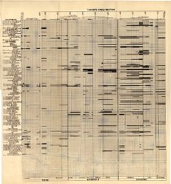
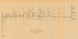
Topical Subject: Geology, Stratigraphic--Ordovician
Remove constraint Subject: Topical Subject: Geology, Stratigraphic--Ordovician