
Search Constraints
You searched for:
Publisher
Indiana. State Highway Commission (1961-1981)
Remove constraint Publisher: Indiana. State Highway Commission (1961-1981)
1 - 7 of 7
Search Results
-
- Subject:
- Geographic Subject: Indiana and Topical Subject: Roads
- Creator:
- Indiana. State Highway Commission (1961-1981)
- Publisher:
- Indiana. State Highway Commission (1961-1981)
- Date Created:
- 1962
- Identifier:
- VAC3073-M-01224
- Genre:
- Road maps
- Geographic Location:
- Coordinates: W0880500 W0844700 N0414500 N0374600
- Related URL:
- Catalog URL: https://iucat.iu.edu/catalog/18406041
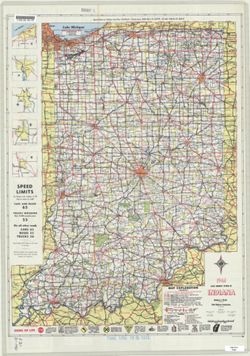
- Abstract:
- Panel title: 1962 Indiana official highway map. Relief shown by spot heights. Includes index, distance table, color illustrations, and text. Index, distance ...
- Call Number:
- G1403 .S7 1962
- Caption:
- Imprint: [Indianapolis] : State Highway Commission, [1962]
- Physical Description:
- Scale: Approximately 1:633,600 and Dimensions: 94 x 59 cm
- Alternate Identifier:
- Title Control Number: a18406041
- Persistent URL:
- https://purl.dlib.indiana.edu/iudl/images/VAC3073/VAC3073-M-01224
- Provenance:
- Indiana state highway system
-
- Subject:
- Topical Subject: Roads and Geographic Subject: Indiana
- Creator:
- Indiana. State Highway Commission (1961-1981)
- Publisher:
- Indiana. State Highway Commission (1961-1981)
- Date Created:
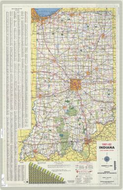
- 1981
- Identifier:
- VAC3073-M-01208
- Genre:
- Road maps
- Geographic Location:
- Coordinates: W0880500 W0844700 N0414500 N0374600
- Related URL:
- Catalog URL: https://iucat.iu.edu/catalog/18406091
- Abstract:
- Panel title: Indiana 1981-82 official highway map. Relief shown by spot heights. Includes index, text and distance chart. Text, Department of Natural Resourc...
- Call Number:
- G1403 .S7 1981-1982
- Caption:
- Imprint: [Indianapolis] : Indiana Department of Highways, [1981]
- Physical Description:
- Scale: Approximately 1:633,600 and Dimensions: 94 x 59 cm
- Alternate Identifier:
- Title Control Number: a18406091
- Persistent URL:
- https://purl.dlib.indiana.edu/iudl/images/VAC3073/VAC3073-M-01208
- Provenance:
- Indiana state highway system
-
- Subject:
- Geographic Subject: Indiana and Topical Subject: Roads
- Creator:
- Indiana. State Highway Commission (1961-1981). Division of Planning
- Publisher:
- Indiana. State Highway Commission (1961-1981)
- Date Created:
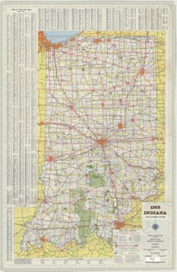
- 1969
- Identifier:
- VAC3073-M-01198
- Genre:
- Road maps
- Geographic Location:
- Coordinates: W0880500 W0844700 N0414500 N0374600
- Related URL:
- Catalog URL: https://iucat.iu.edu/catalog/18406068
- Abstract:
- Panel title: 1969 Indiana official highway map : 50th anniversary 1919-1969. Relief shown by spot heights. Includes index, text, and list of state highway ga...
- Call Number:
- G1403.S7 1969
- Caption:
- Imprint: [Indianapolis] : State Highway Commission, [1969]
- Physical Description:
- Scale: 1:633,600 and Dimensions: 94 x 59 cm
- Alternate Identifier:
- Title Control Number: a18406068
- Persistent URL:
- https://purl.dlib.indiana.edu/iudl/images/VAC3073/VAC3073-M-01198
- Provenance:
- Indiana state highway system
-
- Subject:
- Geographic Subject: Indiana and Topical Subject: Roads
- Creator:
- Indiana. State Highway Commission (1961-1981)
- Publisher:
- Indiana. State Highway Commission (1961-1981)
- Date Created:
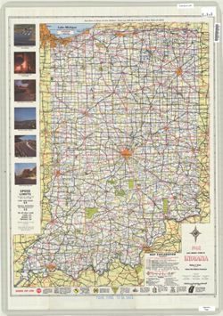
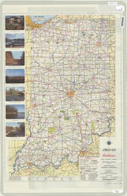
- 1963
- Identifier:
- VAC3073-M-01187
- Genre:
- Road maps
- Geographic Location:
- Coordinates: W0880500 W0844700 N0414500 N0374600
- Related URL:
- Catalog URL: https://iucat.iu.edu/catalog/18406044
- Abstract:
- Panel title: 1963-64 Indiana official highway map. Includes index, distance chart, color illustrations, and text. Index, distance chart, index and chart of s...
- Call Number:
- G1403.S7 1963-64
- Caption:
- Imprint: Indianapolis, Ind. : Indiana State Highway Commission, [1963?]
- Physical Description:
- Dimensions: 94 x 59 cm and Scale: Approximately 1:633,600
- Alternate Identifier:
- Title Control Number: a18406044
- Persistent URL:
- https://purl.dlib.indiana.edu/iudl/images/VAC3073/VAC3073-M-01187
- Provenance:
- Indiana state highway system
-
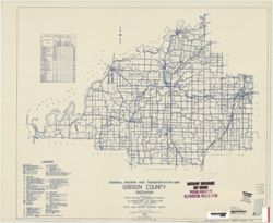
- Subject:
- Geographic Subject: Gibson County (Ind.) and Topical Subject: Roads
- Creator:
- Indiana. State Highway Commission (1919-1953)
- Publisher:
- Indiana. State Highway Commission (1961-1981)
- Date Created:
- 1949
- Identifier:
- VAC3073-M-00935
- Genre:
- Road maps
- Geographic Location:
- Coordinates: W0875900 W0871900 N0383200 N0381000
- Related URL:
- Catalog URL: https://iucat.iu.edu/catalog/5705940
- Abstract:
- Blueline. "State roads revised to January 1, 1949." "1937." "Data obtained from Statewide Highway Planning Survey." Includes lo...
- Call Number:
- G4093.G5P2 1949 .I53
- Caption:
- Imprint: [Indianapolis?] : State Highway Commission of Indiana, 1949.
- Physical Description:
- Dimensions: 44 x 52 cm and Scale: 1:130,000
- Alternate Identifier:
- Title Control Number: a9530630
- Persistent URL:
- https://purl.dlib.indiana.edu/iudl/images/VAC3073/VAC3073-M-00935
-
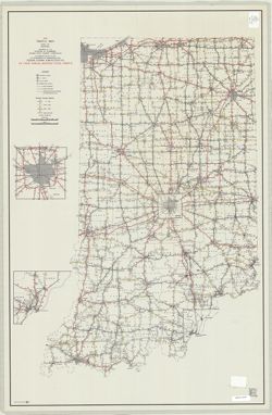
- Subject:
- Geographic Subject: Indiana and Topical Subject: Roads
- Creator:
- Indiana. State Highway Commission (1961-1981)
- Publisher:
- Indiana. State Highway Commission (1961-1981)
- Date Created:
- 1961
- Identifier:
- VAC3073-M-00879
- Genre:
- Road maps
- Geographic Location:
- Coordinates: W0880500 W0844700 N0414500 N0374600
- Related URL:
- Catalog URL: https://iucat.iu.edu/catalog/18406038
- Abstract:
- Gray on white with "controlled access sections on primary roads where project agreement requires B.P.R. approval before any driveway permits can be gran...
- Call Number:
- G1403 .S7 1961
- Caption:
- Imprint: [Indianapolis] : State Highway Commission, [1961]
- Physical Description:
- Scale: Approximately 1:633,600 and Dimensions: 94 x 59 cm
- Alternate Identifier:
- Title Control Number: a18406038
- Persistent URL:
- https://purl.dlib.indiana.edu/iudl/images/VAC3073/VAC3073-M-00879
- Provenance:
- Indiana state highway system
-
- Subject:
- Topical Subject: Traffic flow and Geographic Subject: Indiana
- Creator:
- Indiana. State Highway Commission (1961-1981). Division of Planning
- Publisher:
- Indiana. State Highway Commission (1961-1981)
- Date Created:
- 1969
- Identifier:
- VAC3073-M-00754
- Genre:
- Thematic maps
- Geographic Location:
- Coordinates: W0880500 W0844700 N0414500 N0374600
- Related URL:
- Catalog URL: https://iucat.iu.edu/catalog/6083372
- Abstract:
- Insets: Indianapolis--[New Albany area].
- Call Number:
- G4091.P21 1969 .I5
- Caption:
- Imprint: [Indianapolis] : Indiana State Highway Commission, [1969]
- Physical Description:
- Scale: 1:650,000 and Dimensions: 94 x 61 cm
- Alternate Identifier:
- Title Control Number: a6083372
- Persistent URL:
- https://purl.dlib.indiana.edu/iudl/images/VAC3073/VAC3073-M-00754
