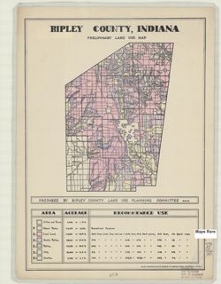
Geographic Subject: Ripley County (Ind.) and Topical Subject: Land use
Creator:
Ripley County (Ind.). Land Use Planning Committee
Publisher:
United States. Bureau of Agricultural Economics
Date Created:
1940
Identifier:
VAC3073-M-00030
Genre:
Thematic maps
Geographic Location:
Coordinates: W0852641 W0850354 N0391837 N0385446
Related URL:
Catalog URL: https://iucat.iu.edu/catalog/5126533
Abstract:
"Color reproduction by Bureau of Agricultural Economics, U.S.D.A." "8-21-40" Includes chart showing type of land use, acreage, and recomm...
Call Number:
G4093.R5 G4 1940 .R57
Caption:
Imprint: [Washington, D.C.?] : U.S. Bureau of Agricultural Economics, [1940]
Physical Description:
Dimensions: 21 x 16 cm, on sheet 38 x 28 cm and Scale: Scale not given.

![Floyd County [Indiana] land use map : preliminary](https://iiif.uits.iu.edu/iiif/2/r207vr80n%2Ffiles%2Fba1ce671-118c-499c-8c40-0c3612b65e19/full/250,/0/default.jpg)

![Spencer County [Indiana] land use map : preliminary](https://iiif.uits.iu.edu/iiif/2/1c18fj180%2Ffiles%2F9c0b4a8c-6bc8-420c-af21-908a4b5f3ba4/full/250,/0/default.jpg)
![Washington County [Indiana] land use map : preliminary](https://iiif.uits.iu.edu/iiif/2/vq280q904%2Ffiles%2F783115ab-1c66-4d7e-b7d2-60280c29643b/full/250,/0/default.jpg)