
Search Constraints
Search Results
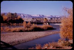
-
- Description:
- 25 f 9
- Subject:
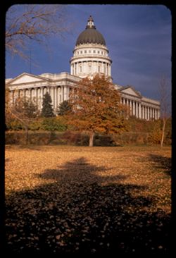
- Capitol Hill (Salt Lake City, Utah), Colonnades, Shadows, Tree limbs, Lawns, Shrubs, Utah Capitol, Pediments, Domes, Columns, Leaves, Trees, Capitols, and Hills
- Series:
- 28-52
- Creator:
- Cushman, Charles W., 1896-1972
- Date Created:
- 1952-11-06
- Genre:
- Architectural photographs
- Frame Number:
- 6
- County:
- Salt Lake
- Abstract:
- Capitol from SW.
- Call Number:
- P06490
- City:
- Salt Lake City
- Country:
- United States
- State/Province:
- Utah
- Alternate Identifier:
- 2852.6
- Persistent URL:
- http://purl.dlib.indiana.edu/iudl/archives/cushman/P06490
- Holding Location:
- Bloomington - University Archives
Wells Library E460
1320 E 10th St.
Bloomington, IN 47405
Contact at archives@indiana.edu, 812-855-1127
-
- Description:
- 25 f 6.3
- Subject:
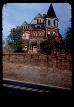
- Cities & towns, Streets, Houses, Windows, Dormers, Lawns, Trees, Retaining walls, Porches, Doors & doorways, Hills, and Towers
- Series:
- 28-52
- Creator:
- Cushman, Charles W., 1896-1972
- Date Created:
- 1952-11-06
- Genre:
- Architectural photographs
- Frame Number:
- 4
- Street Address:
- North Main Street
- County:
- Salt Lake
- Abstract:
- Old house high up hill. N. Main St.
- Call Number:
- P06488
- City:
- Salt Lake City
- Country:
- United States
- State/Province:
- Utah
- Physical Description:
- masked.
- Alternate Identifier:
- 2852.4
- Persistent URL:
- http://purl.dlib.indiana.edu/iudl/archives/cushman/P06488
- Holding Location:
- Bloomington - University Archives
Wells Library E460
1320 E 10th St.
Bloomington, IN 47405
Contact at archives@indiana.edu, 812-855-1127
-
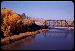
- Description:
- 25 f 9
- Subject:
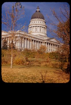
- Capitol Hill (Salt Lake City, Utah), Trees, Lawns, Shrubs, Utah Capitol, Windows, Pediments, Domes, Columns, Leaves, Colonnades, and Capitols
- Series:
- 28-52
- Creator:
- Cushman, Charles W., 1896-1972
- Date Created:
- 1952-11-06
- Genre:
- Architectural photographs
- Frame Number:
- 5
- County:
- Salt Lake
- Abstract:
- Capitol from SW.
- Call Number:
- P06489
- City:
- Salt Lake City
- Country:
- United States
- State/Province:
- Utah
- Physical Description:
- masked.
- Alternate Identifier:
- 2852.5
- Persistent URL:
- http://purl.dlib.indiana.edu/iudl/archives/cushman/P06489
- Holding Location:
- Bloomington - University Archives
Wells Library E460
1320 E 10th St.
Bloomington, IN 47405
Contact at archives@indiana.edu, 812-855-1127
-
- Subject:
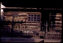
- Houses, Historic buildings, Flowers, Plaques, Temple Square (Salt Lake City, Utah), Log cabins, Fences, Shrubs, Windows, Frontier & pioneer life, Doors &...
- Series:
- 28-52
- Creator:
- Cushman, Charles W., 1896-1972
- Date Created:
- 1952-11-06
- Genre:
- Architectural photographs
- Frame Number:
- 3
- County:
- Salt Lake
- Abstract:
- A Pioneer Home in Temple Sq. - blt in Sept 1847.
- Call Number:
- P06487
- City:
- Salt Lake City
- Country:
- United States
- State/Province:
- Utah
- Alternate Identifier:
- 2852.3
- Persistent URL:
- http://purl.dlib.indiana.edu/iudl/archives/cushman/P06487
- Holding Location:
- Bloomington - University Archives
Wells Library E460
1320 E 10th St.
Bloomington, IN 47405
Contact at archives@indiana.edu, 812-855-1127
-
- Description:
- 25 f 8
- Subject:
- Railings, Capitol Hill (Salt Lake City, Utah), Trees, Flowers, Walkways, Temple Square (Salt Lake City, Utah), Temples, Street lights, Shrubs, Windows, Domes...
- Series:
- 28-52
- Creator:
- Cushman, Charles W., 1896-1972
- Date Created:
- 1952-11-06
- Genre:
- Views
- Frame Number:
- 2
- County:
- Salt Lake
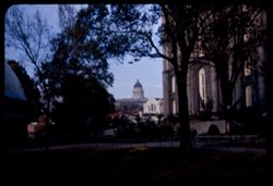
- Abstract:
- Capitol dome from Temple Square.
- Call Number:
- P06486
- City:
- Salt Lake City
- Country:
- United States
- State/Province:
- Utah
- Alternate Identifier:
- 2852.2
- Persistent URL:
- http://purl.dlib.indiana.edu/iudl/archives/cushman/P06486
- Holding Location:
- Bloomington - University Archives
Wells Library E460
1320 E 10th St.
Bloomington, IN 47405
Contact at archives@indiana.edu, 812-855-1127
-
- Description:
- 25 f 9
- Subject:
- Towers, Spires, Battlements, Trees, Temples, Finials, Steeples, Mormon churches, Walls, Stonework, and Tree limbs
- Series:
- 28-52
- Creator:
- Cushman, Charles W., 1896-1972
- Date Created:
- 1952-11-06
- Genre:
- Architectural photographs
- Frame Number:
- 1
- County:
- Salt Lake
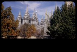
- Abstract:
- Temple towers.
- Call Number:
- P06485
- City:
- Salt Lake City
- Country:
- United States
- State/Province:
- Utah
- Physical Description:
- masked.
- Alternate Identifier:
- 2852.1
- Persistent URL:
- http://purl.dlib.indiana.edu/iudl/archives/cushman/P06485
- Holding Location:
- Bloomington - University Archives
Wells Library E460
1320 E 10th St.
Bloomington, IN 47405
Contact at archives@indiana.edu, 812-855-1127
-
- Description:
- 25 f 4.8 Pola
- Subject:
- City Creek (Salt Lake County, Utah), Automobiles, Trees, Streets, Tree limbs, Cities & towns, Capitols, Utah Capitol, Hills, Columns, Capitol Hill (Salt ...
- Series:
- 27-52
- Creator:
- Cushman, Charles W., 1896-1972
- Date Created:
- 1952-11-06
- Genre:
- Views
- Frame Number:
- 39
- County:
- Salt Lake
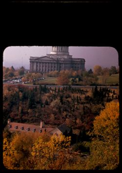
- Abstract:
- Utah Capitol across City Creek.
- Call Number:
- P06484
- City:
- Salt Lake City
- Country:
- United States
- State/Province:
- Utah
- Physical Description:
- masked.
- Alternate Identifier:
- 2752.39
- Persistent URL:
- http://purl.dlib.indiana.edu/iudl/archives/cushman/P06484
- Holding Location:
- Bloomington - University Archives
Wells Library E460
1320 E 10th St.
Bloomington, IN 47405
Contact at archives@indiana.edu, 812-855-1127
-
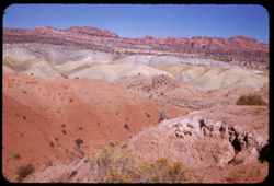
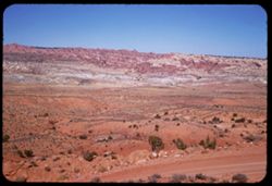
- Description:
- 25 f 8+
- Subject:
- Snow, Roads, Barbed wire, Trees, Mountains, Buildings, Shrubs, Hills, Rivers, and Fences
- Series:
- 27-52
- Creator:
- Cushman, Charles W., 1896-1972
- Date Created:
- 1952-11-05
- Genre:
- Landscape photographs
- Frame Number:
- 37
- County:
- Utah
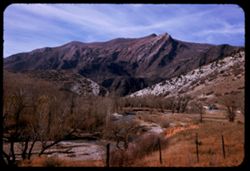
- Abstract:
- Little river and same big dark mountain.
- Call Number:
- P06482
- City:
- Thistle
- Country:
- United States
- State/Province:
- Utah
- Alternate Identifier:
- 2752.37
- Persistent URL:
- http://purl.dlib.indiana.edu/iudl/archives/cushman/P06482
- Holding Location:
- Bloomington - University Archives
Wells Library E460
1320 E 10th St.
Bloomington, IN 47405
Contact at archives@indiana.edu, 812-855-1127
-
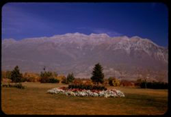
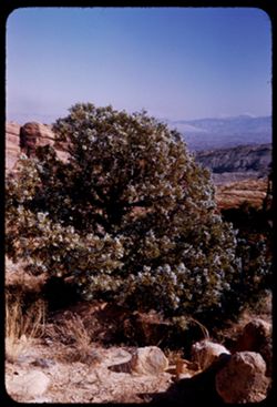
- Description:
- 25 f 6.3 Pola
- Subject:
- Trees, Flowers, Mountains, Lawns, Shrubs, Timpanogos, Mount (Utah), and Utility poles
- Series:
- 27-52
- Creator:
- Cushman, Charles W., 1896-1972
- Date Created:
- 1952-11-05
- Genre:
- Landscape photographs
- Frame Number:
- 38
- County:
- Utah
- Abstract:
- Great rock mtn north of Provo. 11,957 ft.
- Call Number:
- P06483
- City:
- Provo
- Country:
- United States
- State/Province:
- Utah
- Alternate Identifier:
- 2752.38
- Persistent URL:
- http://purl.dlib.indiana.edu/iudl/archives/cushman/P06483
- Holding Location:
- Bloomington - University Archives
Wells Library E460
1320 E 10th St.
Bloomington, IN 47405
Contact at archives@indiana.edu, 812-855-1127
-
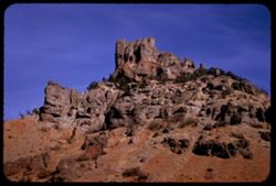
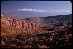
- Description:
- 25 f 9
- Subject:
- Rocks, Electric lines, Cliffs, Boulders, Mountains, Rock formations, Hills, and Shrubs
- Series:
- 27-52
- Creator:
- Cushman, Charles W., 1896-1972
- Date Created:
- 1952-11-05
- Genre:
- Snapshots and Identification photographs
- Frame Number:
- 34
- Street Address:
- United States Highway 50
- County:
- Utah
- Abstract:
- Odd rock formation Utah Co. Utah.
- Call Number:
- P06479
- Country:
- United States
- State/Province:
- Utah
- Alternate Identifier:
- 2752.34
- Persistent URL:
- http://purl.dlib.indiana.edu/iudl/archives/cushman/P06479
- Holding Location:
- Bloomington - University Archives
Wells Library E460
1320 E 10th St.
Bloomington, IN 47405
Contact at archives@indiana.edu, 812-855-1127
-
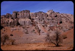
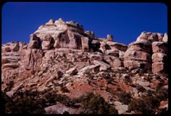
- Description:
- 25 f 9
- Subject:
- Hills, Barbed wire, Cliffs, Mountains, Shrubs, Trees, Rock formations, Fences, and Boulders
- Series:
- 27-52
- Creator:
- Cushman, Charles W., 1896-1972
- Date Created:
- 1952-11-05
- Genre:
- Landscape photographs
- Frame Number:
- 35
- Street Address:
- United States Highway 50
- County:
- Utah
- Abstract:
- Odd rock formation - east of Thistle.
- Call Number:
- P06480
- City:
- Thistle
- Country:
- United States
- State/Province:
- Utah
- Alternate Identifier:
- 2752.35
- Persistent URL:
- http://purl.dlib.indiana.edu/iudl/archives/cushman/P06480
- Holding Location:
- Bloomington - University Archives
Wells Library E460
1320 E 10th St.
Bloomington, IN 47405
Contact at archives@indiana.edu, 812-855-1127
-
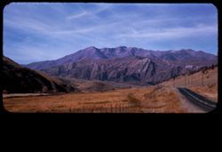
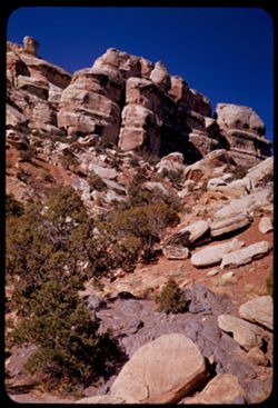
- Description:
- 25 f 9
- Subject:
- Roads, Barbed wire, Mountains, Fences, Shrubs, Hills, and Utility poles
- Series:
- 27-52
- Creator:
- Cushman, Charles W., 1896-1972
- Date Created:
- 1952-11-05
- Genre:
- Landscape photographs
- Frame Number:
- 36
- Street Address:
- United States Highway 50
- County:
- Utah
- Abstract:
- Mountain Mass looking W along US 50 a few miles east of Thistle.
- Call Number:
- P06481
- City:
- Thistle
- Country:
- United States
- State/Province:
- Utah
- Physical Description:
- masked.
- Alternate Identifier:
- 2752.36
- Persistent URL:
- http://purl.dlib.indiana.edu/iudl/archives/cushman/P06481
- Holding Location:
- Bloomington - University Archives
Wells Library E460
1320 E 10th St.
Bloomington, IN 47405
Contact at archives@indiana.edu, 812-855-1127
-
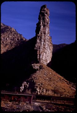
- Description:
- 25 f 9
- Subject:
- Denver and Rio Grande Western Railway Company, Scylla and Charybdis (Greek mythology), Railroad facilities, Rocks, Price River (Utah), Charybdis, Hills, Moun...
- Series:
- 27-52
- Creator:
- Cushman, Charles W., 1896-1972
- Date Created:
- 1952-11-05
- Genre:
- Landscape photographs
- Frame Number:
- 33
- County:
- Carbon
- Abstract:
- Scylla + Charydis at Royal on Price river
- Call Number:
- P06478
- City:
- Royal and Helper
- Country:
- United States
- State/Province:
- Utah
- Alternate Identifier:
- 2752.33
- Persistent URL:
- http://purl.dlib.indiana.edu/iudl/archives/cushman/P06478
- Holding Location:
- Bloomington - University Archives
Wells Library E460
1320 E 10th St.
Bloomington, IN 47405
Contact at archives@indiana.edu, 812-855-1127
-
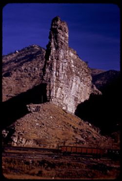
- Description:
- 25 f 11
- Subject:
- Scylla and Charybdis (Greek mythology), Canyons, Electric lines, Cliffs, Charybdis, Buttes, Mountains, Denver and Rio Grande Western Railway Company, Rock fo...
- Series:
- 27-52
- Creator:
- Cushman, Charles W., 1896-1972
- Date Created:
- 1952-11-05
- Genre:
- Landscape photographs
- Frame Number:
- 32
- County:
- Carbon
- Abstract:
- Scylla + Charydis at Royal on Price river.
- Call Number:
- P06477
- City:
- Royal
- Country:
- United States
- State/Province:
- Utah
- Alternate Identifier:
- 2752.32
- Persistent URL:
- http://purl.dlib.indiana.edu/iudl/archives/cushman/P06477
- Holding Location:
- Bloomington - University Archives
Wells Library E460
1320 E 10th St.
Bloomington, IN 47405
Contact at archives@indiana.edu, 812-855-1127
-
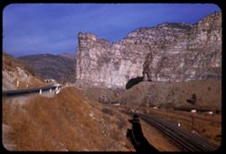
- Description:
- 25 f 9
- Subject:
- Canyons, Roads, Mountains, Denver and Rio Grande Western Railway Company, Rock formations, Railroad tracks, Railroad cars, Coal, Cliffs, Buildings, Price Riv...
- Series:
- 27-52
- Creator:
- Cushman, Charles W., 1896-1972
- Date Created:
- 1952-11-05
- Genre:
- Landscape photographs
- Frame Number:
- 31
- Street Address:
- United States Highway 50
- County:
- Carbon
- Abstract:
- Hwy 50 runs through Price river gorge along with D + RGW at Royal, north of Helper.
- Call Number:
- P06476
- City:
- Royal and Helper
- Country:
- United States
- State/Province:
- Utah
- Alternate Identifier:
- 2752.31
- Persistent URL:
- http://purl.dlib.indiana.edu/iudl/archives/cushman/P06476
- Holding Location:
- Bloomington - University Archives
Wells Library E460
1320 E 10th St.
Bloomington, IN 47405
Contact at archives@indiana.edu, 812-855-1127
-
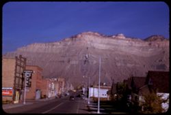
- Description:
- 25 f 11
- Subject:
- Billboards, Houses, Automobiles, Streets, Cities & towns, Sidewalks, Hotels, Electric signs, La Salle Hotel, Coca-Cola Company, Cliffs, Mountains, Buildi...
- Series:
- 27-52
- Creator:
- Cushman, Charles W., 1896-1972
- Date Created:
- 1952-11-05
- Genre:
- Views
- Frame Number:
- 30
- Street Address:
- United States Highway 50
- County:
- Carbon
- Abstract:
- Helper, Utah.
- Call Number:
- P06475
- City:
- Helper
- Country:
- United States
- State/Province:
- Utah
- Alternate Identifier:
- 2752.30
- Persistent URL:
- http://purl.dlib.indiana.edu/iudl/archives/cushman/P06475
- Holding Location:
- Bloomington - University Archives
Wells Library E460
1320 E 10th St.
Bloomington, IN 47405
Contact at archives@indiana.edu, 812-855-1127
-
- Description:
- 25 f 6.3 Pola
- Subject:
- National parks & reserves, Hills, Shrubs, Sandstone, Rock formations, Wildflowers, Arches National Park (Utah), and Dunes
- Series:
- 27-52
- Creator:
- Cushman, Charles W., 1896-1972
- Date Created:
- 1952-11-04
- Genre:
- Landscape photographs
- Frame Number:
- 29
- County:
- Grand
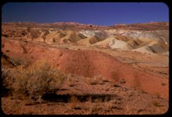
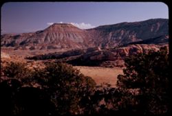
- Abstract:
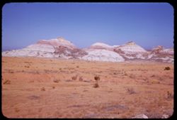
- Sulfurous green mounds sandstone.
- Call Number:
- P06474
- Country:
- United States
- State/Province:
- Utah
- Alternate Identifier:
- 2752.29
- Persistent URL:
- http://purl.dlib.indiana.edu/iudl/archives/cushman/P06474
- Holding Location:
- Bloomington - University Archives
Wells Library E460
1320 E 10th St.
Bloomington, IN 47405
Contact at archives@indiana.edu, 812-855-1127
-
- Description:
- 50 f 8+
- Subject:
- National parks & reserves, Cliffs, Shrubs, Trees, Buttes, Rock formations, Junipers, and Arches National Park (Utah)
- Series:
- 27-52
- Creator:
- Cushman, Charles W., 1896-1972
- Date Created:
- 1952-11-04
- Genre:
- Identification photographs and Landscape photographs
- Frame Number:
- 28
- County:
- Grand
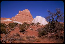
- Abstract:
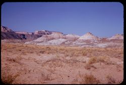
- Red fin, white glob, + juniper.
- Call Number:
- P06473
- Country:
- United States
- State/Province:
- Utah
- Alternate Identifier:
- 2752.28
- Persistent URL:
- http://purl.dlib.indiana.edu/iudl/archives/cushman/P06473
- Holding Location:
- Bloomington - University Archives
Wells Library E460
1320 E 10th St.
Bloomington, IN 47405
Contact at archives@indiana.edu, 812-855-1127
-
- Description:
- 50 f 8+
- Subject:
- Skyline Arch (Utah), National parks & reserves, Devils Garden (Grand County, Utah), Cliffs, Shrubs, Trees, Buttes, Arches National Park (Utah), and Rock ...
- Series:
- 27-52
- Creator:
- Cushman, Charles W., 1896-1972
- Date Created:
- 1952-11-04
- Genre:
- Landscape photographs
- Frame Number:
- 27
- County:
- Grand
- Abstract:
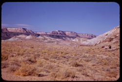
- Skyline Arch.
- Call Number:
- P06472
- Country:
- United States
- State/Province:
- Utah
- Alternate Identifier:
- 2752.27
- Persistent URL:
- http://purl.dlib.indiana.edu/iudl/archives/cushman/P06472
- Holding Location:
- Bloomington - University Archives
Wells Library E460
1320 E 10th St.
Bloomington, IN 47405
Contact at archives@indiana.edu, 812-855-1127
-
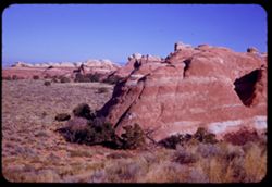
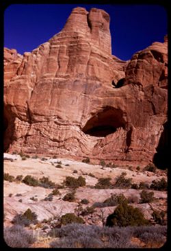
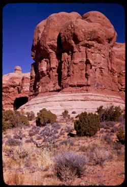
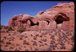
- Description:
- 50 f 8
- Subject:
- Rock formations, Trees, Arches National Park (Utah), National parks & reserves, Shadows, Cliffs, Buttes, Devils Garden (Grand County, Utah), and Shrubs
- Series:
- 27-52
- Creator:
- Cushman, Charles W., 1896-1972
- Date Created:
- 1952-11-04
- Genre:
- Landscape photographs
- Frame Number:
- 25
- County:
- Grand
- Abstract:
- In the Devils Garden.
- Call Number:
- P06470
- Country:
- United States
- State/Province:
- Utah
- Alternate Identifier:
- 2752.25
- Persistent URL:
- http://purl.dlib.indiana.edu/iudl/archives/cushman/P06470
- Holding Location:
- Bloomington - University Archives
Wells Library E460
1320 E 10th St.
Bloomington, IN 47405
Contact at archives@indiana.edu, 812-855-1127
-
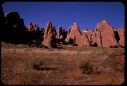
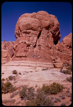
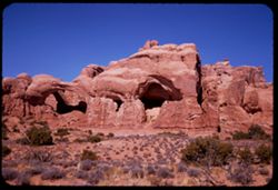
- Description:
- 50 f 8+
- Subject:
- Cliffs, Trees, Buttes, National parks & reserves, Arches National Park (Utah), Shrubs, Rock formations, and Devils Garden (Grand County, Utah)
- Series:
- 27-52
- Creator:
- Cushman, Charles W., 1896-1972
- Date Created:
- 1952-11-04
- Genre:
- Landscape photographs
- Frame Number:
- 26
- County:
- Grand
- Abstract:
- In the Devils Garden
- Call Number:
- P06471
- Country:
- United States
- State/Province:
- Utah
- Alternate Identifier:
- 2752.26
- Persistent URL:
- http://purl.dlib.indiana.edu/iudl/archives/cushman/P06471
- Holding Location:
- Bloomington - University Archives
Wells Library E460
1320 E 10th St.
Bloomington, IN 47405
Contact at archives@indiana.edu, 812-855-1127
-
- Description:
- 50 f 9
- Subject:
- Cliffs, Shadows, Buttes, Rock formations, Devils Garden (Grand County, Utah), National parks & reserves, Shrubs, and Arches National Park (Utah)
- Series:
- 27-52
- Creator:
- Cushman, Charles W., 1896-1972
- Date Created:
- 1952-11-04
- Genre:
- Landscape photographs
- Frame Number:
- 24
- County:
- Grand
- Abstract:
- Almost there.
- Call Number:
- P06469
- Country:
- United States
- State/Province:
- Utah
- Alternate Identifier:
- 2752.24
- Persistent URL:
- http://purl.dlib.indiana.edu/iudl/archives/cushman/P06469
- Holding Location:
- Bloomington - University Archives
Wells Library E460
1320 E 10th St.
Bloomington, IN 47405
Contact at archives@indiana.edu, 812-855-1127
-
- Description:
- 50 f 9
- Subject:
- Cliffs, Trees, Buttes, Rock formations, Devils Garden (Grand County, Utah), National parks & reserves, Shrubs, and Arches National Park (Utah)
- Series:
- 27-52
- Creator:
- Cushman, Charles W., 1896-1972
- Date Created:
- 1952-11-04
- Genre:
- Landscape photographs
- Frame Number:
- 22
- County:
- Grand
- Abstract:
- Almost at the Devils Garden.
- Call Number:
- P06467
- City:
- Moab
- Country:
- United States
- State/Province:
- Utah
- Alternate Identifier:
- 2752.22
- Persistent URL:
- http://purl.dlib.indiana.edu/iudl/archives/cushman/P06467
- Holding Location:
- Bloomington - University Archives
Wells Library E460
1320 E 10th St.
Bloomington, IN 47405
Contact at archives@indiana.edu, 812-855-1127
-
- Description:
- 50 f 9
- Subject:
- Cliffs, Trees, Buttes, National parks & reserves, Arches National Park (Utah), Hills, Shrubs, Rock formations, and Devils Garden (Grand County, Utah)
- Series:
- 27-52
- Creator:
- Cushman, Charles W., 1896-1972
- Date Created:
- 1952-11-04
- Genre:
- Landscape photographs
- Frame Number:
- 23
- County:
- Grand
- Abstract:
- Almost at the Devils Garden.
- Call Number:
- P06468
- Country:
- United States
- State/Province:
- Utah
- Alternate Identifier:
- 2752.23
- Persistent URL:
- http://purl.dlib.indiana.edu/iudl/archives/cushman/P06468
- Holding Location:
- Bloomington - University Archives
Wells Library E460
1320 E 10th St.
Bloomington, IN 47405
Contact at archives@indiana.edu, 812-855-1127
-
- Description:
- 50 f 9
- Subject:
- National parks & reserves, Deserts, Devils Garden (Grand County, Utah), Hills, Sand, Mountains, Shrubs, Arches National Park (Utah), Wildflowers, Rock fo...
- Series:
- 27-52
- Creator:
- Cushman, Charles W., 1896-1972
- Date Created:
- 1952-11-04
- Genre:
- Landscape photographs
- Frame Number:
- 21
- County:
- Grand
- Abstract:
- En route to Devil's Garden. Sandstone Dunes.
- Call Number:
- P06466
- Country:
- United States
- State/Province:
- Utah
- Alternate Identifier:
- 2752.21
- Persistent URL:
- http://purl.dlib.indiana.edu/iudl/archives/cushman/P06466
- Holding Location:
- Bloomington - University Archives
Wells Library E460
1320 E 10th St.
Bloomington, IN 47405
Contact at archives@indiana.edu, 812-855-1127
-
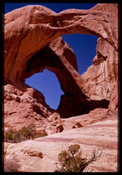
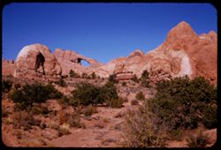
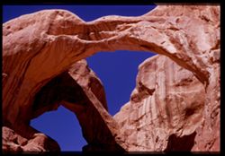
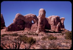
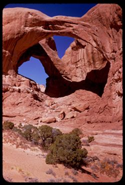
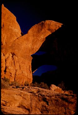
- Description:
- 50 f 7
- Subject:
- National parks & reserves, Double Arch (Utah), Cliffs, Trees, Shadows, Arches National Park (Utah), and Rock formations
- Series:
- 27-52
- Creator:
- Cushman, Charles W., 1896-1972
- Date Created:
- 1952-11-04
- Genre:
- Landscape photographs
- Frame Number:
- 17
- County:
- Grand
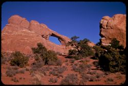
- Abstract:
- Up into Double Arch.
- Call Number:
- P06462
- City:
- Moab
- Country:
- United States
- State/Province:
- Utah
- Physical Description:
- Image was originally mounted in a glass enclosure. Before digitization, the image was removed and placed in a Wess Plastic, Inc. brand, 2" x 2", pl...
- Alternate Identifier:
- 2752.17
- Persistent URL:
- http://purl.dlib.indiana.edu/iudl/archives/cushman/P06462
- Holding Location:
- Bloomington - University Archives
Wells Library E460
1320 E 10th St.
Bloomington, IN 47405
Contact at archives@indiana.edu, 812-855-1127
-
- Description:
- 50 f 9
- Subject:
- Rocks, Cliffs, Dirt roads, Trees, Mountains, National parks & reserves, Devils Garden (Grand County, Utah), Hills, Shrubs, and Arches National Park (Utah)
- Series:
- 27-52
- Creator:
- Cushman, Charles W., 1896-1972
- Date Created:
- 1952-11-04
- Genre:
- Landscape photographs
- Frame Number:
- 20
- County:
- Grand
- Abstract:
- En route to Devil's Garden.
- Call Number:
- P06465
- Country:
- United States
- State/Province:
- Utah
- Alternate Identifier:
- 2752.20
- Persistent URL:
- http://purl.dlib.indiana.edu/iudl/archives/cushman/P06465
- Holding Location:
- Bloomington - University Archives
Wells Library E460
1320 E 10th St.
Bloomington, IN 47405
Contact at archives@indiana.edu, 812-855-1127
-
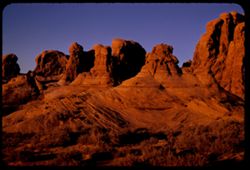
- Description:
- 50 f 6
- Subject:
- Cliffs, Shadows, National parks & reserves, Arches National Park (Utah), Double Arch (Utah), and Rock formations
- Series:
- 27-52
- Creator:
- Cushman, Charles W., 1896-1972
- Date Created:
- 1952-11-04
- Genre:
- Snapshots
- Frame Number:
- 18
- County:
- Grand
- Abstract:
- Up into Double Arch.
- Call Number:
- P06463
- Country:
- United States
- State/Province:
- Utah
- Physical Description:
- Image was originally mounted in a glass enclosure. Before digitization, the image was removed and placed in a Wess Plastic, Inc. brand, 2" x 2", pl...
- Alternate Identifier:
- 2752.18
- Persistent URL:
- http://purl.dlib.indiana.edu/iudl/archives/cushman/P06463
- Holding Location:
- Bloomington - University Archives
Wells Library E460
1320 E 10th St.
Bloomington, IN 47405
Contact at archives@indiana.edu, 812-855-1127
-
- Description:
- 50 f 8
- Subject:
- Cliffs, Shadows, Buttes, Entrada Sandstone, Shrubs, Arches National Park (Utah), Caves, Navajo Sandstone, National parks & reserves, and Rock formations
- Series:
- 27-52
- Creator:
- Cushman, Charles W., 1896-1972
- Date Created:
- 1952-11-04
- Genre:
- Landscape photographs
- Frame Number:
- 19
- County:
- Grand
- Abstract:
- Geology lesson. 3 layers of rock: Entrada, Carmel, Navajo Sandstone.
- Call Number:
- P06464
- Country:
- United States
- State/Province:
- Utah
- Alternate Identifier:
- 2752.19
- Persistent URL:
- http://purl.dlib.indiana.edu/iudl/archives/cushman/P06464
- Holding Location:
- Bloomington - University Archives
Wells Library E460
1320 E 10th St.
Bloomington, IN 47405
Contact at archives@indiana.edu, 812-855-1127
-
- Description:
- 50 f 5.6
- Subject:
- Cliffs, Buttes, National parks & reserves, Arches National Park (Utah), and Rock formations
- Series:
- 27-52
- Creator:
- Cushman, Charles W., 1896-1972
- Date Created:
- 1952-11-04
- Genre:
- Snapshots and Identification photographs
- Frame Number:
- 16
- County:
- Grand
- Abstract:
- Towering rock of cobalt sky.
- Call Number:
- P06461
- City:
- Moab
- Country:
- United States
- State/Province:
- Utah
- Physical Description:
- Image was originally mounted in a glass enclosure. Before digitization, the image was removed and placed in a Wess Plastic, Inc. brand, 2" x 2", pl...
- Alternate Identifier:
- 2752.16
- Persistent URL:
- http://purl.dlib.indiana.edu/iudl/archives/cushman/P06461
- Holding Location:
- Bloomington - University Archives
Wells Library E460
1320 E 10th St.
Bloomington, IN 47405
Contact at archives@indiana.edu, 812-855-1127
-
- Description:
- 50 f 8+
- Subject:
- National parks & reserves, Cliffs, Shrubs, Buttes, Arches National Park (Utah), and Rock formations
- Series:
- 27-52
- Creator:
- Cushman, Charles W., 1896-1972
- Date Created:
- 1952-11-04
- Genre:
- Landscape photographs
- Frame Number:
- 15
- County:
- Grand
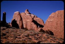
- Abstract:
- A great round bulbous tower from another angle.
- Call Number:
- P06460
- Country:
- United States
- State/Province:
- Utah
- Alternate Identifier:
- 2752.15
- Persistent URL:
- http://purl.dlib.indiana.edu/iudl/archives/cushman/P06460
- Holding Location:
- Bloomington - University Archives
Wells Library E460
1320 E 10th St.
Bloomington, IN 47405
Contact at archives@indiana.edu, 812-855-1127
-
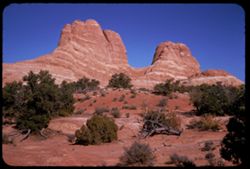
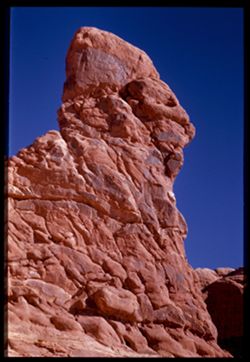
- Description:
- 50 f 8+
- Subject:
- Cliffs, Buttes, Rock formations, Arches National Park (Utah), National parks & reserves, and Shrubs
- Series:
- 27-52
- Creator:
- Cushman, Charles W., 1896-1972
- Date Created:
- 1952-11-04
- Genre:
- Landscape photographs
- Frame Number:
- 14
- County:
- Grand
- Abstract:
- A great round bulbous tower.
- Call Number:
- P06459
- Country:
- United States
- State/Province:
- Utah
- Alternate Identifier:
- 2752.14
- Persistent URL:
- http://purl.dlib.indiana.edu/iudl/archives/cushman/P06459
- Holding Location:
- Bloomington - University Archives
Wells Library E460
1320 E 10th St.
Bloomington, IN 47405
Contact at archives@indiana.edu, 812-855-1127
-
- Description:
- 50 f 8+
- Subject:
- Cliffs, Trees, Shadows, Buttes, Rock formations, Arches National Park (Utah), Double Arch (Utah), Caves, National parks & reserves, and Shrubs
- Series:
- 27-52
- Creator:
- Cushman, Charles W., 1896-1972
- Date Created:
- 1952-11-04
- Genre:
- Landscape photographs
- Frame Number:
- 13
- County:
- Grand
- Abstract:
- Formation to right (e) of Double Arch.
- Call Number:
- P06458
- Country:
- United States
- State/Province:
- Utah
- Alternate Identifier:
- 2752.13
- Persistent URL:
- http://purl.dlib.indiana.edu/iudl/archives/cushman/P06458
- Holding Location:
- Bloomington - University Archives
Wells Library E460
1320 E 10th St.
Bloomington, IN 47405
Contact at archives@indiana.edu, 812-855-1127
-
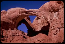
- Description:
- 50 f 8.5
- Subject:
- Caves, National parks & reserves, Double Arch (Utah), Cliffs, Shrubs, Trees, Shadows, Buttes, Arches National Park (Utah), and Rock formations
- Series:
- 27-52
- Creator:
- Cushman, Charles W., 1896-1972
- Date Created:
- 1952-11-04
- Genre:
- Landscape photographs
- Frame Number:
- 12
- County:
- Grand
- Abstract:
- Double Arch from a distance.
- Call Number:
- P06457
- City:
- Moab
- Country:
- United States
- State/Province:
- Utah
- Alternate Identifier:
- 2752.12
- Persistent URL:
- http://purl.dlib.indiana.edu/iudl/archives/cushman/P06457
- Holding Location:
- Bloomington - University Archives
Wells Library E460
1320 E 10th St.
Bloomington, IN 47405
Contact at archives@indiana.edu, 812-855-1127
-
- Description:
- 50 f 7
- Subject:
- Cliffs, Trees, Buttes, Shrubs, Arches National Park (Utah), Parade of Elephants (Utah), National parks & reserves, and Rock formations
- Series:
- 27-52
- Creator:
- Cushman, Charles W., 1896-1972
- Date Created:
- 1952-11-04
- Genre:
- Landscape photographs
- Frame Number:
- 11
- County:
- Grand
- Abstract:
- Parade of Elephants.
- Call Number:
- P06456
- City:
- Moab
- Country:
- United States
- State/Province:
- Utah
- Alternate Identifier:
- 2752.11
- Persistent URL:
- http://purl.dlib.indiana.edu/iudl/archives/cushman/P06456
- Holding Location:
- Bloomington - University Archives
Wells Library E460
1320 E 10th St.
Bloomington, IN 47405
Contact at archives@indiana.edu, 812-855-1127
-
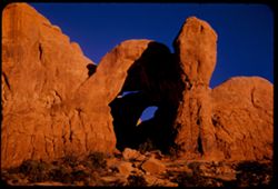
- Description:
- 25 f 11
- Subject:
- Cliffs, Shadows, Rock formations, Arches National Park (Utah), Double Arch (Utah), and National parks & reserves
- Series:
- 27-52
- Creator:
- Cushman, Charles W., 1896-1972
- Date Created:
- 1952-11-04
- Genre:
- Snapshots and Identification photographs
- Frame Number:
- 9
- County:
- Grand
- Abstract:
- Double Arch.
- Call Number:
- P06454
- City:
- Moab
- Country:
- United States
- State/Province:
- Utah
- Alternate Identifier:
- 2752.9
- Persistent URL:
- http://purl.dlib.indiana.edu/iudl/archives/cushman/P06454
- Holding Location:
- Bloomington - University Archives
Wells Library E460
1320 E 10th St.
Bloomington, IN 47405
Contact at archives@indiana.edu, 812-855-1127
-
- Description:
- 50 f 8
- Subject:
- Rocks, Cliffs, Trees, Boulders, Shadows, Rock formations, Arches National Park (Utah), Double Arch (Utah), National parks & reserves, and Shrubs
- Series:
- 27-52
- Creator:
- Cushman, Charles W., 1896-1972
- Date Created:
- 1952-11-04
- Genre:
- Landscape photographs
- Frame Number:
- 10
- County:
- Grand
- Abstract:
- Double Arch.
- Call Number:
- P06455
- City:
- Moab
- Country:
- United States
- State/Province:
- Utah
- Alternate Identifier:
- 2752.10
- Persistent URL:
- http://purl.dlib.indiana.edu/iudl/archives/cushman/P06455
- Holding Location:
- Bloomington - University Archives
Wells Library E460
1320 E 10th St.
Bloomington, IN 47405
Contact at archives@indiana.edu, 812-855-1127
-
Charles W. Cushman Photograph Collection
Collection
- Description:
- Charles Weever Cushman, amateur photographer and Indiana University alumnus, bequeathed approximately 14,500 Kodachrome color slides to his alma mater. The p...
- Related URL:
- https://libraries.indiana.edu/cushman-photograph-collection-highlights
3Subcollections14461Works -
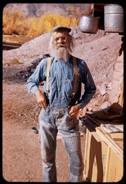
- Description:
- 1/50 f 6.3 or f 5.6
- Subject:
- Rocks, Men, Pails, Trees, Bowls (Tableware), Mountains, Pots & pans, Crates, Hills, Stone walls, and Dwellings
- Series:
- 27-52
- Creator:
- Cushman, Charles W., 1896-1972
- Date Created:
- 1952-11-04
- Genre:
- Portraits
- Frame Number:
- 1
- County:
- Grand
- Persons Pictured:
- Holley, Jack W.
- Abstract:
- 1 to 7 - at Jack Holley's abode.
- Call Number:
- P06446
- City:
- Moab
- Country:
- United States
- State/Province:
- Utah
- Alternate Identifier:
- 2752.1
- Persistent URL:
- http://purl.dlib.indiana.edu/iudl/archives/cushman/P06446
- Holding Location:
- Bloomington - University Archives
Wells Library E460
1320 E 10th St.
Bloomington, IN 47405
Contact at archives@indiana.edu, 812-855-1127
-
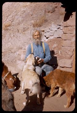
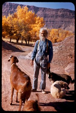
- Subject:
- Dogs, Stone walls, Puppies, Men, Hills, Shrubs, Families, Rocks, Bowls (Tableware), Goats, and Shadows
- Series:
- 26-52
- Creator:
- Cushman, Charles W., 1896-1972
- Date Created:
- 1952-11-04
- Genre:
- Portraits
- Frame Number:
- 39
- County:
- Grand
- Persons Pictured:
- Holley, Jack W.
- Abstract:
- Jack W. Holley and family. Dandy, 3 dogs + 1 puppy.
- Call Number:
- P06445
- City:
- Moab
- Country:
- United States
- State/Province:
- Utah
- Alternate Identifier:
- 2652.39
- Persistent URL:
- http://purl.dlib.indiana.edu/iudl/archives/cushman/P06445
- Holding Location:
- Bloomington - University Archives
Wells Library E460
1320 E 10th St.
Bloomington, IN 47405
Contact at archives@indiana.edu, 812-855-1127
-
- Description:
- ?
- Subject:
- Dogs, Puppies, Men, Hills, Cliffs, Mountains, Dirt roads, Families, Goats, and Trees
- Series:
- 26-52
- Creator:
- Cushman, Charles W., 1896-1972
- Date Created:
- 1952-11-04
- Genre:
- Portraits
- Frame Number:
- 38
- County:
- Grand
- Persons Pictured:
- Holley, Jack W.
- Abstract:
- Jack W. Holley and family. Dandy, 3 dogs + 1 puppy.
- Call Number:
- P06444
- City:
- Moab
- Country:
- United States
- State/Province:
- Utah
- Alternate Identifier:
- 2652.38
- Persistent URL:
- http://purl.dlib.indiana.edu/iudl/archives/cushman/P06444
- Holding Location:
- Bloomington - University Archives
Wells Library E460
1320 E 10th St.
Bloomington, IN 47405
Contact at archives@indiana.edu, 812-855-1127
-
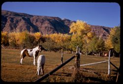
- Description:
- 25 f 10
- Subject:
- Meadows, Horses, Barbed wire, Cliffs, Mountains, Trees, Grazing, and Fences
- Series:
- 26-52
- Creator:
- Cushman, Charles W., 1896-1972
- Date Created:
- 1952-11-04
- Genre:
- Identification photographs
- Frame Number:
- 37
- County:
- Grand
- Abstract:
- Horse + colt in field at Moab.
- Call Number:
- P06443
- City:
- Moab
- Country:
- United States
- State/Province:
- Utah
- Alternate Identifier:
- 2652.37
- Persistent URL:
- http://purl.dlib.indiana.edu/iudl/archives/cushman/P06443
- Holding Location:
- Bloomington - University Archives
Wells Library E460
1320 E 10th St.
Bloomington, IN 47405
Contact at archives@indiana.edu, 812-855-1127
-

- Description:
- 25 f 10
- Subject:
- Cliffs, Mountains, Shrubs, and Trees
- Series:
- 26-52
- Creator:
- Cushman, Charles W., 1896-1972
- Date Created:
- 1952-11-04
- Genre:
- Landscape photographs
- Frame Number:
- 36
- County:
- Grand
- Abstract:
- High ridge back.
- Call Number:
- P06442
- City:
- Moab
- Country:
- United States
- State/Province:
- Utah
- Alternate Identifier:
- 2652.36
- Persistent URL:
- http://purl.dlib.indiana.edu/iudl/archives/cushman/P06442
- Holding Location:
- Bloomington - University Archives
Wells Library E460
1320 E 10th St.
Bloomington, IN 47405
Contact at archives@indiana.edu, 812-855-1127
-
- Description:
- 25 f 8
- Subject:
- Cliffs, Shadows, Buttes, Rock formations, Arches National Park (Utah), National parks & reserves, and Shrubs
- Series:
- 26-52
- Creator:
- Cushman, Charles W., 1896-1972
- Date Created:
- 1952-11-03
- Genre:
- Landscape photographs
- Frame Number:
- 35
- County:
- Grand
- Abstract:
- Fantastic shapes in waning light
- Call Number:
- P06441
- City:
- Moab
- Country:
- United States
- State/Province:
- Utah
- Physical Description:
- Image was originally mounted in a glass enclosure. Before digitization, the image was removed and placed in a Wess Plastic, Inc. brand, 2" x 2", pl...
- Alternate Identifier:
- 2652.35
- Persistent URL:
- http://purl.dlib.indiana.edu/iudl/archives/cushman/P06441
- Holding Location:
- Bloomington - University Archives
Wells Library E460
1320 E 10th St.
Bloomington, IN 47405
Contact at archives@indiana.edu, 812-855-1127
-
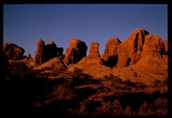
- Description:
- 25 f 9
- Subject:
- Cliffs, Boulders, Shadows, Buttes, Shrubs, Arches National Park (Utah), Double Arch (Utah), National parks & reserves, and Rock formations
- Series:
- 26-52
- Creator:
- Cushman, Charles W., 1896-1972
- Date Created:
- 1952-11-03
- Genre:
- Landscape photographs
- Frame Number:
- 33
- County:
- Grand
- Abstract:
- Double arch.
- Call Number:
- P06439
- City:
- Moab
- Country:
- United States
- State/Province:
- Utah
- Alternate Identifier:
- 2652.33
- Persistent URL:
- http://purl.dlib.indiana.edu/iudl/archives/cushman/P06439
- Holding Location:
- Bloomington - University Archives
Wells Library E460
1320 E 10th St.
Bloomington, IN 47405
Contact at archives@indiana.edu, 812-855-1127
-
- Description:
- 25 f 8
- Subject:
- Cliffs, Shadows, Buttes, Shrubs, Arches National Park (Utah), National parks & reserves, and Rock formations
- Series:
- 26-52
- Creator:
- Cushman, Charles W., 1896-1972
- Date Created:
- 1952-11-03
- Genre:
- Landscape photographs
- Frame Number:
- 34
- County:
- Grand
- Abstract:
- Fantastic shapes in waning light.
- Call Number:
- P06440
- City:
- Moab
- Country:
- United States
- State/Province:
- Utah
- Alternate Identifier:
- 2652.34
- Persistent URL:
- http://purl.dlib.indiana.edu/iudl/archives/cushman/P06440
- Holding Location:
- Bloomington - University Archives
Wells Library E460
1320 E 10th St.
Bloomington, IN 47405
Contact at archives@indiana.edu, 812-855-1127
-
- Description:
- 25 f 5.6 Pola
- Subject:
- Cliffs, Boulders, Shadows, Buttes, National parks & reserves, Arches National Park (Utah), Double Arch (Utah), Shrubs, and Rock formations
- Series:
- 26-52
- Creator:
- Cushman, Charles W., 1896-1972
- Date Created:
- 1952-11-03
- Genre:
- Landscape photographs
- Frame Number:
- 32
- County:
- Grand
- Abstract:
- Double arch.
- Call Number:
- P06438
- City:
- Moab
- Country:
- United States
- State/Province:
- Utah
- Alternate Identifier:
- 2652.32
- Persistent URL:
- http://purl.dlib.indiana.edu/iudl/archives/cushman/P06438
- Holding Location:
- Bloomington - University Archives
Wells Library E460
1320 E 10th St.
Bloomington, IN 47405
Contact at archives@indiana.edu, 812-855-1127
-
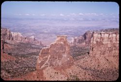
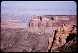
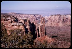
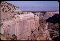
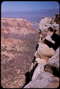
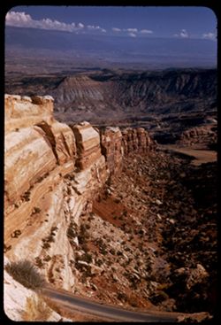
- Description:
- 25 f 11
- Subject:
- Valleys, Cliffs, Colorado National Monument (Colo.), Grand View Overlook (Colo.), Mesas, Colorado River (Colo.-Mexico), Buttes, Mountains, Rock formations, C...
- Series:
- 26-52
- Creator:
- Cushman, Charles W., 1896-1972
- Date Created:
- 1952-11-03
- Genre:
- Landscape photographs
- Frame Number:
- 19
- County:
- Mesa
- Abstract:
- from Grandview Overlook.
- Call Number:
- P06425
- City:
- Grand Junction
- Country:
- United States
- State/Province:
- Colorado
- Alternate Identifier:
- 2652.19
- Persistent URL:
- http://purl.dlib.indiana.edu/iudl/archives/cushman/P06425
- Holding Location:
- Bloomington - University Archives
Wells Library E460
1320 E 10th St.
Bloomington, IN 47405
Contact at archives@indiana.edu, 812-855-1127
-
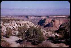
- Description:
- 25 f 11
- Subject:
- Valleys, Cliffs, Colorado National Monument (Colo.), Mesas, Buttes, Rock formations, Trees, National parks & reserves, and Shrubs
- Series:
- 26-52
- Creator:
- Cushman, Charles W., 1896-1972
- Date Created:
- 1952-11-03
- Genre:
- Landscape photographs
- Frame Number:
- 18
- Abstract:
- view north.
- Call Number:
- P06424
- Country:
- United States
- State/Province:
- Colorado
- Alternate Identifier:
- 2652.18
- Persistent URL:
- http://purl.dlib.indiana.edu/iudl/archives/cushman/P06424
- Holding Location:
- Bloomington - University Archives
Wells Library E460
1320 E 10th St.
Bloomington, IN 47405
Contact at archives@indiana.edu, 812-855-1127
-
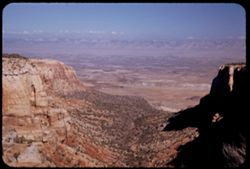
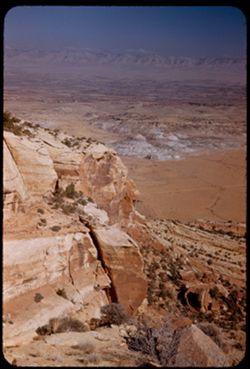
- Description:
- 25 f 11
- Subject:
- Valleys, Bodies of water, Cliffs, Colorado National Monument (Colo.), Mesas, Colorado River (Colo.-Mexico), Shadows, Mountains, Rock formations, Colorado Riv...
- Series:
- 26-52
- Creator:
- Cushman, Charles W., 1896-1972
- Date Created:
- 1952-11-03
- Genre:
- Landscape photographs
- Frame Number:
- 17
- County:
- Mesa
- Abstract:
- view north.
- Call Number:
- P06423
- City:
- Grand Junction
- Country:
- United States
- State/Province:
- Colorado
- Alternate Identifier:
- 2652.17
- Persistent URL:
- http://purl.dlib.indiana.edu/iudl/archives/cushman/P06423
- Holding Location:
- Bloomington - University Archives
Wells Library E460
1320 E 10th St.
Bloomington, IN 47405
Contact at archives@indiana.edu, 812-855-1127
-
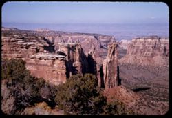
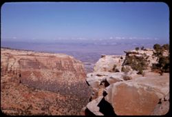
- Description:
- 25 f 11
- Subject:
- Tree limbs, Valleys, Colorado National Monument (Colo.), Cliffs, Grand View Overlook (Colo.), Buttes, Scenic overlooks, Mesas, National parks & reserves,...
- Series:
- 26-52
- Creator:
- Cushman, Charles W., 1896-1972
- Date Created:
- 1952-11-03
- Genre:
- Landscape photographs
- Frame Number:
- 16
- Abstract:
- view north.
- Call Number:
- P06422
- Country:
- United States
- State/Province:
- Colorado
- Alternate Identifier:
- 2652.16
- Persistent URL:
- http://purl.dlib.indiana.edu/iudl/archives/cushman/P06422
- Holding Location:
- Bloomington - University Archives
Wells Library E460
1320 E 10th St.
Bloomington, IN 47405
Contact at archives@indiana.edu, 812-855-1127
-
- Description:
- 25 f 6.3 Pola
- Subject:
- Rocks, Canyons, Cliffs, Colorado National Monument (Colo.), Shadows, Buttes, Shrubs, National parks & reserves, and Rock formations
- Series:
- 26-52
- Creator:
- Cushman, Charles W., 1896-1972
- Date Created:
- 1952-11-03
- Genre:
- Landscape photographs
- Frame Number:
- 14
- County:
- Mesa
- Abstract:
- Grand.
- Call Number:
- P06421
- City:
- Grand Junction
- Country:
- United States
- State/Province:
- Colorado
- Alternate Identifier:
- 2652.14
- Persistent URL:
- http://purl.dlib.indiana.edu/iudl/archives/cushman/P06421
- Holding Location:
- Bloomington - University Archives
Wells Library E460
1320 E 10th St.
Bloomington, IN 47405
Contact at archives@indiana.edu, 812-855-1127
-
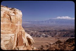
- Description:
- 25 f 11
- Subject:
- Cliffs, Colorado National Monument (Colo.), Mesas, Artists Point (Colorado National Monument (Colo.)), Shrubs, Trees, and National parks & reserves
- Series:
- 26-52
- Creator:
- Cushman, Charles W., 1896-1972
- Date Created:
- 1952-11-03
- Genre:
- Landscape photographs
- Frame Number:
- 13
- Abstract:
- At Artists Point.
- Call Number:
- P06420
- Country:
- United States
- State/Province:
- Colorado
- Alternate Identifier:
- 2652.13
- Persistent URL:
- http://purl.dlib.indiana.edu/iudl/archives/cushman/P06420
- Holding Location:
- Bloomington - University Archives
Wells Library E460
1320 E 10th St.
Bloomington, IN 47405
Contact at archives@indiana.edu, 812-855-1127
-
- Description:
- 25 f 12
- Subject:
- Canyons, Cliffs, Colorado National Monument (Colo.), Mesas, Shadows, Mountains, Rock formations, Roads, National parks & reserves, and Shrubs
- Series:
- 26-52
- Creator:
- Cushman, Charles W., 1896-1972
- Date Created:
- 1952-11-03
- Genre:
- Landscape photographs
- Frame Number:
- 12
- County:
- Mesa
- Abstract:
- Grand shelves.
- Call Number:
- P06419
- City:
- Grand Junction
- Country:
- United States
- State/Province:
- Colorado
- Alternate Identifier:
- 2652.12
- Persistent URL:
- http://purl.dlib.indiana.edu/iudl/archives/cushman/P06419
- Holding Location:
- Bloomington - University Archives
Wells Library E460
1320 E 10th St.
Bloomington, IN 47405
Contact at archives@indiana.edu, 812-855-1127
-
- Description:
- 25 f 12
- Subject:
- National parks & reserves, Canyons, Colorado National Monument (Colo.), Cliffs, Mountains, Shrubs, Trees, Scenic overlooks, and Mesas
- Series:
- 26-52
- Creator:
- Cushman, Charles W., 1896-1972
- Date Created:
- 1952-11-03
- Genre:
- Landscape photographs
- Frame Number:
- 11
- Abstract:
- View from Highland Overlook.
- Call Number:
- P06418
- Country:
- United States
- State/Province:
- Colorado
- Alternate Identifier:
- 2652.11
- Persistent URL:
- http://purl.dlib.indiana.edu/iudl/archives/cushman/P06418
- Holding Location:
- Bloomington - University Archives
Wells Library E460
1320 E 10th St.
Bloomington, IN 47405
Contact at archives@indiana.edu, 812-855-1127
-
- Description:
- 25 f 8 Pola
- Subject:
- Valleys, Cliffs, Colorado National Monument (Colo.), Mesas, Shadows, Mountains, National parks & reserves, Colorado River Valley (Colo.-Mexico), Canyons,...
- Series:
- 26-52
- Creator:
- Cushman, Charles W., 1896-1972
- Date Created:
- 1952-11-03
- Genre:
- Landscape photographs
- Frame Number:
- 10
- Abstract:
- Panorama down the canyon.
- Call Number:
- P06417
- Country:
- United States
- State/Province:
- Colorado
- Alternate Identifier:
- 2652.10
- Persistent URL:
- http://purl.dlib.indiana.edu/iudl/archives/cushman/P06417
- Holding Location:
- Bloomington - University Archives
Wells Library E460
1320 E 10th St.
Bloomington, IN 47405
Contact at archives@indiana.edu, 812-855-1127
-
- Description:
- 25 f 8 Pola
- Subject:
- Colorado National Monument (Colo.), Mountains, Trees, Canyons, Cold Shivers Point (Colo.), National parks & reserves, Shrubs, Mesas, and Cliffs
- Series:
- 26-52
- Creator:
- Cushman, Charles W., 1896-1972
- Date Created:
- 1952-11-03
- Genre:
- Landscape photographs
- Frame Number:
- 9
- Abstract:
- From Cold Shivers Pt.
- Call Number:
- P06416
- Country:
- United States
- State/Province:
- Colorado
- Alternate Identifier:
- 2652.9
- Persistent URL:
- http://purl.dlib.indiana.edu/iudl/archives/cushman/P06416
- Holding Location:
- Bloomington - University Archives
Wells Library E460
1320 E 10th St.
Bloomington, IN 47405
Contact at archives@indiana.edu, 812-855-1127
-
- Description:
- 25 f 11
- Subject:
- Canyons, Cliffs, Colorado National Monument (Colo.), Mesas, Shadows, Mountains, National parks & reserves, Cold Shivers Point (Colo.), and Shrubs
- Series:
- 26-52
- Creator:
- Cushman, Charles W., 1896-1972
- Date Created:
- 1952-11-03
- Genre:
- Landscape photographs
- Frame Number:
- 8
- Abstract:
- From Cold Shivers Pt.
- Call Number:
- P06415
- Country:
- United States
- State/Province:
- Colorado
- Alternate Identifier:
- 2652.8
- Persistent URL:
- http://purl.dlib.indiana.edu/iudl/archives/cushman/P06415
- Holding Location:
- Bloomington - University Archives
Wells Library E460
1320 E 10th St.
Bloomington, IN 47405
Contact at archives@indiana.edu, 812-855-1127
-
- Description:
- 25 f 8 Pola
- Subject:
- Colorado River Valley (Colo.-Mexico), National parks & reserves, Deserts, Valleys, Colorado National Monument (Colo.), Cliffs, Mountains, Shrubs, Buttes,...
- Series:
- 26-52
- Creator:
- Cushman, Charles W., 1896-1972
- Date Created:
- 1952-11-03
- Genre:
- Landscape photographs
- Frame Number:
- 6
- County:
- Mesa
- Abstract:
- View down [P] across buttes + valley of Colo. River.
- Call Number:
- P06413
- City:
- Grand Junction
- Country:
- United States
- State/Province:
- Colorado
- Alternate Identifier:
- 2652.6
- Persistent URL:
- http://purl.dlib.indiana.edu/iudl/archives/cushman/P06413
- Holding Location:
- Bloomington - University Archives
Wells Library E460
1320 E 10th St.
Bloomington, IN 47405
Contact at archives@indiana.edu, 812-855-1127
-
- Description:
- 25 f 6.3 Pola
- Subject:
- Roads, Colorado National Monument (Colo.), Mesas, Mountains, Shrubs, Cliffs, and National parks & reserves
- Series:
- 26-52
- Creator:
- Cushman, Charles W., 1896-1972
- Date Created:
- 1952-11-03
- Genre:
- Landscape photographs
- Frame Number:
- 7
- Abstract:
- Down along 1st rock wall.
- Call Number:
- P06414
- Country:
- United States
- State/Province:
- Colorado
- Alternate Identifier:
- 2652.7
- Persistent URL:
- http://purl.dlib.indiana.edu/iudl/archives/cushman/P06414
- Holding Location:
- Bloomington - University Archives
Wells Library E460
1320 E 10th St.
Bloomington, IN 47405
Contact at archives@indiana.edu, 812-855-1127
-
- Description:
- 25 f 6.3 Pola
- Subject:
- Deserts, Cliffs, Colorado National Monument (Colo.), Mesas, Buttes, Mountains, Shrubs, Clouds, Roads, Trees, and National parks & reserves
- Series:
- 26-52
- Creator:
- Cushman, Charles W., 1896-1972
- Date Created:
- 1952-11-03
- Genre:
- Landscape photographs
- Frame Number:
- 5
- County:
- Mesa
- Abstract:
- View over Grnd Juctn.
- Call Number:
- P06412
- City:
- Grand Junction
- Country:
- United States
- State/Province:
- Colorado
- Alternate Identifier:
- 2652.5
- Persistent URL:
- http://purl.dlib.indiana.edu/iudl/archives/cushman/P06412
- Holding Location:
- Bloomington - University Archives
Wells Library E460
1320 E 10th St.
Bloomington, IN 47405
Contact at archives@indiana.edu, 812-855-1127
-
- Description:
- 25 f 6.3 Pola
- Subject:
- Rocks, Canyons, Cliffs, Colorado National Monument (Colo.), Mesas, Boulders, Mountains, Shrubs, Clouds, Valleys, and National parks & reserves
- Series:
- 26-52
- Creator:
- Cushman, Charles W., 1896-1972
- Date Created:
- 1952-11-04
- Genre:
- Landscape photographs
- Frame Number:
- 4
- County:
- Mesa
- Abstract:
- East along red rock wall.
- Call Number:
- P06411
- City:
- Grand Junction
- Country:
- United States
- State/Province:
- Colorado
- Alternate Identifier:
- 2652.4
- Persistent URL:
- http://purl.dlib.indiana.edu/iudl/archives/cushman/P06411
- Holding Location:
- Bloomington - University Archives
Wells Library E460
1320 E 10th St.
Bloomington, IN 47405
Contact at archives@indiana.edu, 812-855-1127
-
- Description:
- 25 f 9
- Subject:
- National parks & reserves, Berries, Colorado National Monument (Colo.), Cliffs, Mountains, Shrubs, Boulders, Rocks, Junipers, and Trees
- Series:
- 26-52
- Creator:
- Cushman, Charles W., 1896-1972
- Date Created:
- 1952-11-03
- Genre:
- Identification photographs
- Frame Number:
- 3
- County:
- Mesa
- Abstract:
- Juniper. A beauty.
- Call Number:
- P06410
- City:
- Grand Junction
- Country:
- United States
- State/Province:
- Colorado
- Alternate Identifier:
- 2652.3
- Persistent URL:
- http://purl.dlib.indiana.edu/iudl/archives/cushman/P06410
- Holding Location:
- Bloomington - University Archives
Wells Library E460
1320 E 10th St.
Bloomington, IN 47405
Contact at archives@indiana.edu, 812-855-1127
-
- Description:
- 25 f 11
- Subject:
- Rocks, Cliffs, Colorado National Monument (Colo.), Trees, Boulders, National parks & reserves, and Rock formations
- Series:
- 26-52
- Creator:
- Cushman, Charles W., 1896-1972
- Date Created:
- 1952-11-03
- Genre:
- Landscape photographs
- Frame Number:
- 2
- County:
- Mesa
- Abstract:
- Looking up at odd shapes.
- Call Number:
- P06409
- City:
- Grand Junction
- Country:
- United States
- State/Province:
- Colorado
- Alternate Identifier:
- 2652.2
- Persistent URL:
- http://purl.dlib.indiana.edu/iudl/archives/cushman/P06409
- Holding Location:
- Bloomington - University Archives
Wells Library E460
1320 E 10th St.
Bloomington, IN 47405
Contact at archives@indiana.edu, 812-855-1127
-
- Description:
- 25 f 11
- Subject:
- Rocks, Cliffs, Colorado National Monument (Colo.), Trees, Boulders, National parks & reserves, and Rock formations
- Series:
- 26-52
- Creator:
- Cushman, Charles W., 1896-1972
- Date Created:
- 1952-11-03
- Genre:
- Landscape photographs
- Frame Number:
- 1
- County:
- Mesa
- Abstract:
- Looking up at odd shapes.
- Call Number:
- P06408
- City:
- Grand Junction
- Country:
- United States
- State/Province:
- Colorado
- Alternate Identifier:
- 2652.1
- Persistent URL:
- http://purl.dlib.indiana.edu/iudl/archives/cushman/P06408
- Holding Location:
- Bloomington - University Archives
Wells Library E460
1320 E 10th St.
Bloomington, IN 47405
Contact at archives@indiana.edu, 812-855-1127
-
- Description:
- 25 f 6.3 Pola
- Subject:
- National parks & reserves, Hills, Colorado National Monument (Colo.), Cliffs, Mountains, Boulders, Rocks, Buttes, Rock formations, Junipers, and Trees
- Series:
- 25-52
- Creator:
- Cushman, Charles W., 1896-1972
- Date Created:
- 1952-11-03
- Genre:
- Landscape photographs
- Frame Number:
- 38
- County:
- Mesa
- Abstract:
- Across juniper tops.
- Call Number:
- P06407
- City:
- Grand Junction
- Country:
- United States
- State/Province:
- Colorado
- Alternate Identifier:
- 2552.38
- Persistent URL:
- http://purl.dlib.indiana.edu/iudl/archives/cushman/P06407
- Holding Location:
- Bloomington - University Archives
Wells Library E460
1320 E 10th St.
Bloomington, IN 47405
Contact at archives@indiana.edu, 812-855-1127
-
- Description:
- 25 f 12
- Subject:
- Valleys, Colorado National Monument (Colo.), Buttes, Mountains, National parks & reserves, Hills, Meadows, and Shrubs
- Series:
- 25-52
- Creator:
- Cushman, Charles W., 1896-1972
- Date Created:
- 1952-11-03
- Genre:
- Landscape photographs
- Frame Number:
- 37
- County:
- Mesa
- Abstract:
- Buttes again.
- Call Number:
- P06406
- City:
- Grand Junction
- Country:
- United States
- State/Province:
- Colorado
- Alternate Identifier:
- 2552.37
- Persistent URL:
- http://purl.dlib.indiana.edu/iudl/archives/cushman/P06406
- Holding Location:
- Bloomington - University Archives
Wells Library E460
1320 E 10th St.
Bloomington, IN 47405
Contact at archives@indiana.edu, 812-855-1127
-
- Description:
- 25 f 13
- Subject:
- Colorado National Monument (Colo.), Mesas, Buttes, Mountains, Shrubs, Hills, Meadows, and National parks & reserves
- Series:
- 25-52
- Creator:
- Cushman, Charles W., 1896-1972
- Date Created:
- 1952-11-03
- Genre:
- Landscape photographs
- Frame Number:
- 36
- County:
- Mesa
- Call Number:
- P06405
- City:
- Grand Junction
- Country:
- United States
- State/Province:
- Colorado
- Alternate Identifier:
- 2552.36
- Persistent URL:
- http://purl.dlib.indiana.edu/iudl/archives/cushman/P06405
- Holding Location:
- Bloomington - University Archives
Wells Library E460
1320 E 10th St.
Bloomington, IN 47405
Contact at archives@indiana.edu, 812-855-1127
-
- Description:
- 25 f 12
- Subject:
- Rocks, Colorado National Monument (Colo.), Mesas, Boulders, Buttes, Mountains, Shrubs, Hills, Meadows, and National parks & reserves
- Series:
- 25-52
- Creator:
- Cushman, Charles W., 1896-1972
- Date Created:
- 1952-11-03
- Genre:
- Landscape photographs
- Frame Number:
- 35
- County:
- Mesa
- Call Number:
- P06404
- City:
- Grand Junction
- Country:
- United States
- State/Province:
- Colorado
- Alternate Identifier:
- 2552.35
- Persistent URL:
- http://purl.dlib.indiana.edu/iudl/archives/cushman/P06404
- Holding Location:
- Bloomington - University Archives
Wells Library E460
1320 E 10th St.
Bloomington, IN 47405
Contact at archives@indiana.edu, 812-855-1127
-
- Description:
- 25 f 11
- Subject:
- Rocks, Mesas, Colorado River (Colo.-Mexico), Tree limbs, Mountains, Shrubs, Islands, Rivers, Trees, and Railroad bridges
- Series:
- 25-52
- Creator:
- Cushman, Charles W., 1896-1972
- Date Created:
- 1952-11-03
- Genre:
- Landscape photographs
- Frame Number:
- 34
- Street Address:
- United States Highway 50
- County:
- Mesa
- Abstract:
- Colorado river at Grand Junction from north end of Hwy 50 bridge
- Call Number:
- P06403
- City:
- Grand Junction
- Country:
- United States
- State/Province:
- Colorado
- Alternate Identifier:
- 2552.34
- Persistent URL:
- http://purl.dlib.indiana.edu/iudl/archives/cushman/P06403
- Holding Location:
- Bloomington - University Archives
Wells Library E460
1320 E 10th St.
Bloomington, IN 47405
Contact at archives@indiana.edu, 812-855-1127
-
- Description:
- 25 f 11
- Subject:
- Reflections, Railroad bridges, Mountains, Shrubs, Trees, Colorado River (Colo.-Mexico), and Rivers
- Series:
- 25-52
- Creator:
- Cushman, Charles W., 1896-1972
- Date Created:
- 1952-11-03
- Genre:
- Landscape photographs
- Frame Number:
- 33
- County:
- Mesa
- Abstract:
- Colorado river at Grand Junction.
- Call Number:
- P06402
- City:
- Grand Junction
- Country:
- United States
- State/Province:
- Colorado
- Alternate Identifier:
- 2552.33
- Persistent URL:
- http://purl.dlib.indiana.edu/iudl/archives/cushman/P06402
- Holding Location:
- Bloomington - University Archives
Wells Library E460
1320 E 10th St.
Bloomington, IN 47405
Contact at archives@indiana.edu, 812-855-1127
-
- Description:
- 25 f 8
- Subject:
- Cliffs, Mesas, Colorado River (Colo.-Mexico), Mountains, Shrubs, Hills, Utility poles, Rivers, and Trees
- Series:
- 25-52
- Creator:
- Cushman, Charles W., 1896-1972
- Date Created:
- 1952-11-02
- Genre:
- Landscape photographs
- Frame Number:
- 32
- County:
- Mesa
- Abstract:
- The Colorado river 14 miles east of Grand Junction.
- Call Number:
- P06401
- City:
- Grand Junction
- Country:
- United States
- State/Province:
- Colorado
- Alternate Identifier:
- 2552.32
- Persistent URL:
- http://purl.dlib.indiana.edu/iudl/archives/cushman/P06401
- Holding Location:
- Bloomington - University Archives
Wells Library E460
1320 E 10th St.
Bloomington, IN 47405
Contact at archives@indiana.edu, 812-855-1127
-
- Description:
- 25 f 3.5
- Subject:
- Automobiles, Denver and Rio Grande Western Railway Company, Railroad cars, Railroad tracks, Mountains, Utility poles, Electric lines, Trees, Railroads, Calif...
- Series:
- 25-52
- Creator:
- Cushman, Charles W., 1896-1972
- Date Created:
- 1952-11-02
- Genre:
- Views
- Frame Number:
- 31
- County:
- Garfield
- Abstract:
- E. bound Calif. Zephyr at Glenwood Springs.
- Call Number:
- P06400
- City:
- Glenwood Springs
- Country:
- United States
- State/Province:
- Colorado
- Alternate Identifier:
- 2552.31
- Persistent URL:
- http://purl.dlib.indiana.edu/iudl/archives/cushman/P06400
- Holding Location:
- Bloomington - University Archives
Wells Library E460
1320 E 10th St.
Bloomington, IN 47405
Contact at archives@indiana.edu, 812-855-1127
-
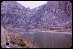
- Description:
- 25 f 2.8
- Subject:
- Canyons, Glenwood Canyon (Colo.), Roads, Cliffs, Railroad tracks, Mountains, Shrubs, Trees, Buildings, Colorado River (Colo.-Mexico), Rivers, Railroad cars, ...
- Series:
- 25-52
- Creator:
- Cushman, Charles W., 1896-1972
- Date Created:
- 1952-11-02
- Genre:
- Landscape photographs
- Frame Number:
- 30
- County:
- Garfield
- Abstract:
- Dark in Glenwood Canyon.
- Call Number:
- P06399
- City:
- Glenwood Springs
- Country:
- United States
- State/Province:
- Colorado
- Alternate Identifier:
- 2552.30
- Persistent URL:
- http://purl.dlib.indiana.edu/iudl/archives/cushman/P06399
- Holding Location:
- Bloomington - University Archives
Wells Library E460
1320 E 10th St.
Bloomington, IN 47405
Contact at archives@indiana.edu, 812-855-1127
-
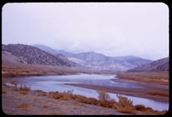
- Description:
- 25 f 6.3
- Subject:
- Hills, Mountains, Shrubs, Colorado River (Colo.-Mexico), and Rivers
- Series:
- 25-52
- Creator:
- Cushman, Charles W., 1896-1972
- Date Created:
- 1952-11-02
- Genre:
- Landscape photographs
- Frame Number:
- 28
- County:
- Garfield
- Abstract:
- Colorado river 16 mi. east of Glenwood Springs.
- Call Number:
- P06397
- City:
- Glenwood Springs
- Country:
- United States
- State/Province:
- Colorado
- Alternate Identifier:
- 2552.28
- Persistent URL:
- http://purl.dlib.indiana.edu/iudl/archives/cushman/P06397
- Holding Location:
- Bloomington - University Archives
Wells Library E460
1320 E 10th St.
Bloomington, IN 47405
Contact at archives@indiana.edu, 812-855-1127
-
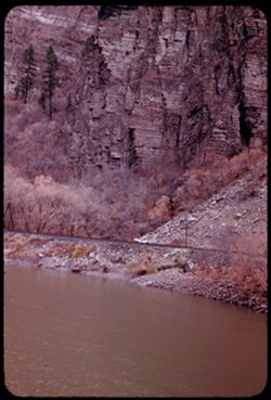
- Description:
- 25 f 4
- Subject:
- Glenwood Canyon (Colo.), Canyons, Electric lines, Cliffs, Trees, Colorado River (Colo.-Mexico), Railroad tracks, Utility poles, Rivers, and Rocks
- Series:
- 25-52
- Creator:
- Cushman, Charles W., 1896-1972
- Date Created:
- 1952-11-02
- Genre:
- Landscape photographs
- Frame Number:
- 29
- County:
- Garfield
- Abstract:
- Wall of Glenwood Canyon.
- Call Number:
- P06398
- City:
- Glenwood Springs
- Country:
- United States
- State/Province:
- Colorado
- Alternate Identifier:
- 2552.29
- Persistent URL:
- http://purl.dlib.indiana.edu/iudl/archives/cushman/P06398
- Holding Location:
- Bloomington - University Archives
Wells Library E460
1320 E 10th St.
Bloomington, IN 47405
Contact at archives@indiana.edu, 812-855-1127
-
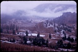
- Description:
- 25 f 6.3
- Subject:
- Snow, Canyons, Houses, Outbuildings, Trees, Mountains, Bridges, Eagle River (Colo.), Rivers, Roads, and Clouds
- Series:
- 25-52
- Creator:
- Cushman, Charles W., 1896-1972
- Date Created:
- 1952-11-02
- Genre:
- Landscape photographs
- Frame Number:
- 27
- Street Address:
- United States Highway 6
- County:
- Eagle
- Abstract:
- Canyon of Eagle river near Minturn (US 6).
- Call Number:
- P06396
- City:
- Minturn
- Country:
- United States
- State/Province:
- Colorado
- Alternate Identifier:
- 2552.27
- Persistent URL:
- http://purl.dlib.indiana.edu/iudl/archives/cushman/P06396
- Holding Location:
- Bloomington - University Archives
Wells Library E460
1320 E 10th St.
Bloomington, IN 47405
Contact at archives@indiana.edu, 812-855-1127
-
- Description:
- 25 f 5.6
- Subject:
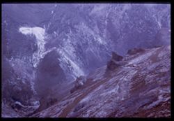
- Snow, Rocky Mountains, Canyons, Red Cliff (Colo.), Trails & paths, Mountains, Forests, Eagle River (Colo.), and Rivers
- Series:
- 25-52
- Creator:
- Cushman, Charles W., 1896-1972
- Date Created:
- 1952-11-02
- Genre:
- Landscape photographs
- Frame Number:
- 26
- County:
- Eagle
- Abstract:
- Looking into some (Eagle river) canyon.
- Call Number:
- P06395
- City:
- Red Cliff
- Country:
- United States
- State/Province:
- Colorado
- Physical Description:
- Image was originally mounted in a glass enclosure. Before digitization, the image was removed and placed in a Wess Plastic, Inc. brand, 2" x 2", pl...
- Alternate Identifier:
- 2552.26
- Persistent URL:
- http://purl.dlib.indiana.edu/iudl/archives/cushman/P06395
- Holding Location:
- Bloomington - University Archives
Wells Library E460
1320 E 10th St.
Bloomington, IN 47405
Contact at archives@indiana.edu, 812-855-1127
-
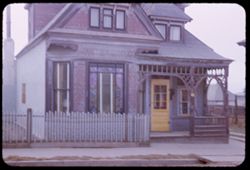
- Description:
- 25 f 4
- Subject:
- Houses, Windows, Sidewalks, Stained glass, Railings, Woodwork, Porches, Doors & doorways, Dormers, and Fences
- Series:
- 25-52
- Creator:
- Cushman, Charles W., 1896-1972
- Date Created:
- 1952-11-02
- Genre:
- Architectural photographs
- Frame Number:
- 24
- County:
- Lake
- Abstract:
- Old house - Leadville.
- Call Number:
- P06393
- City:
- Leadville
- Country:
- United States
- State/Province:
- Colorado
- Alternate Identifier:
- 2552.24
- Persistent URL:
- http://purl.dlib.indiana.edu/iudl/archives/cushman/P06393
- Holding Location:
- Bloomington - University Archives
Wells Library E460
1320 E 10th St.
Bloomington, IN 47405
Contact at archives@indiana.edu, 812-855-1127
-
- Description:
- 25 f 6.3 Pola
- Subject:
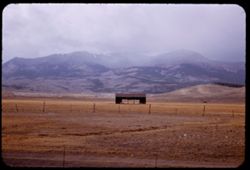
- Rocky Mountains, Dirt roads, Barbed wire, Meadows, Mountains, Fences, Clouds, Hills, Animal housing, and Elbert, Mount (Colo.)
- Series:
- 25-52
- Creator:
- Cushman, Charles W., 1896-1972
- Date Created:
- 1952-11-02
- Genre:
- Landscape photographs
- Frame Number:
- 23
- Abstract:
- Mt. Elbert from east. 14431 ft.
- Call Number:
- P06392
- Country:
- United States
- State/Province:
- Colorado
- Alternate Identifier:
- 2552.23
- Persistent URL:
- http://purl.dlib.indiana.edu/iudl/archives/cushman/P06392
- Holding Location:
- Bloomington - University Archives
Wells Library E460
1320 E 10th St.
Bloomington, IN 47405
Contact at archives@indiana.edu, 812-855-1127
-
- Description:
- 25 f 2.5 Pola
- Subject:
- Snow, Rocky Mountains, Weather, Red Cliff (Colo.), Ice, Storms, Tree limbs, Mountains, Blizzards, Clouds, and Passes (Landforms)
- Series:
- 25-52
- Creator:
- Cushman, Charles W., 1896-1972
- Date Created:
- 1952-11-02
- Genre:
- Views
- Frame Number:
- 25
- County:
- Eagle
- Abstract:
- Snow storm in pass near Redcliff.
- Call Number:
- P06394
- City:
- Red Cliff
- Country:
- United States
- State/Province:
- Colorado
- Alternate Identifier:
- 2552.25
- Persistent URL:
- http://purl.dlib.indiana.edu/iudl/archives/cushman/P06394
- Holding Location:
- Bloomington - University Archives
Wells Library E460
1320 E 10th St.
Bloomington, IN 47405
Contact at archives@indiana.edu, 812-855-1127
-
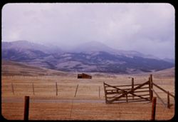
- Description:
- 25 f 5.6 Pola
- Subject:
- Rocky Mountains, Roads, Barbed wire, Meadows, Mountains, Fences, Clouds, Hills, Animal housing, and Elbert, Mount (Colo.)
- Series:
- 25-52
- Creator:
- Cushman, Charles W., 1896-1972
- Date Created:
- 1952-11-02
- Genre:
- Landscape photographs
- Frame Number:
- 22
- Abstract:
- Mt. Elbert - top in shroud. 14431 ft.
- Call Number:
- P06391
- Country:
- United States
- State/Province:
- Colorado
- Alternate Identifier:
- 2552.22
- Persistent URL:
- http://purl.dlib.indiana.edu/iudl/archives/cushman/P06391
- Holding Location:
- Bloomington - University Archives
Wells Library E460
1320 E 10th St.
Bloomington, IN 47405
Contact at archives@indiana.edu, 812-855-1127
-
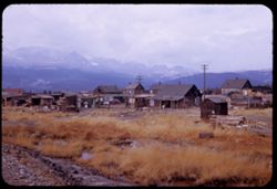
- Description:
- 25 f 8
- Subject:
- Mills, Puddles, Houses, Dirt roads, Mountains, Massive, Mount (Colo.), Huts, Utility poles, Rocks, Electric lines, and Grasses
- Series:
- 25-52
- Creator:
- Cushman, Charles W., 1896-1972
- Date Created:
- 1952-11-02
- Genre:
- Views
- Frame Number:
- 21
- Street Address:
- Stringtown
- County:
- Lake
- Abstract:
- Shacks near Mill - Massive in bkgrd.
- Call Number:
- P06390
- City:
- Leadville
- Country:
- United States
- State/Province:
- Colorado
- Alternate Identifier:
- 2552.21
- Persistent URL:
- http://purl.dlib.indiana.edu/iudl/archives/cushman/P06390
- Holding Location:
- Bloomington - University Archives
Wells Library E460
1320 E 10th St.
Bloomington, IN 47405
Contact at archives@indiana.edu, 812-855-1127
-
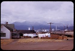
- Description:
- 25 f 5.6 Pola
- Subject:
- Cities & towns, Smokestacks, Houses, Mountains, Clotheslines, Utility poles, Electric lines, Buildings, Clouds, Fences, Industrial facilities, Dirt roads...
- Series:
- 25-52
- Creator:
- Cushman, Charles W., 1896-1972
- Date Created:
- 1952-11-02
- Genre:
- Views
- Frame Number:
- 20
- Street Address:
- Stringtown
- County:
- Lake
- Abstract:
- Mt. Massive from Stringtown.
- Call Number:
- P06389
- City:
- Leadville
- Country:
- United States
- State/Province:
- Colorado
- Alternate Identifier:
- 2552.20
- Persistent URL:
- http://purl.dlib.indiana.edu/iudl/archives/cushman/P06389
- Holding Location:
- Bloomington - University Archives
Wells Library E460
1320 E 10th St.
Bloomington, IN 47405
Contact at archives@indiana.edu, 812-855-1127
-
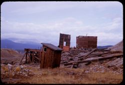
- Description:
- 25 f 6.3
- Subject:
- Rocks, Grasses, Abandoned buildings, Mountains, Hills, Building deterioration, and Ruins
- Series:
- 25-52
- Creator:
- Cushman, Charles W., 1896-1972
- Date Created:
- 1952-11-02
- Genre:
- Snapshots
- Frame Number:
- 18
- County:
- Lake
- Abstract:
- Ruins atop hill at east of Leadville.
- Call Number:
- P06387
- City:
- Leadville
- Country:
- United States
- State/Province:
- Colorado
- Alternate Identifier:
- 2552.18
- Persistent URL:
- http://purl.dlib.indiana.edu/iudl/archives/cushman/P06387
- Holding Location:
- Bloomington - University Archives
Wells Library E460
1320 E 10th St.
Bloomington, IN 47405
Contact at archives@indiana.edu, 812-855-1127
-
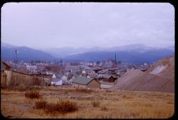
- Description:
- 25 f 6.3
- Subject:
- Rocks, Grasses, Houses, Streets, Mountains, Churches, Shrubs, Hotels, Hills, Cities & towns, and Buildings
- Series:
- 25-52
- Creator:
- Cushman, Charles W., 1896-1972
- Date Created:
- 1952-11-02
- Genre:
- Cityscape photographs
- Frame Number:
- 19
- County:
- Lake
- Abstract:
- Leadville from [?] SE.
- Call Number:
- P06388
- City:
- Leadville
- Country:
- United States
- State/Province:
- Colorado
- Alternate Identifier:
- 2552.19
- Persistent URL:
- http://purl.dlib.indiana.edu/iudl/archives/cushman/P06388
- Holding Location:
- Bloomington - University Archives
Wells Library E460
1320 E 10th St.
Bloomington, IN 47405
Contact at archives@indiana.edu, 812-855-1127
-
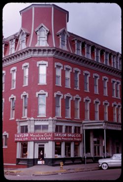
- Description:
- 50 f 4
- Subject:
- Meadow Gold Dairies, Hotels, Cities & towns, Streets, Automobiles, Fire hydrants, Windows, Drugstores, Taylor Drug Company (Leadville, Colo.), Dormers, B...
- Series:
- 25-52
- Creator:
- Cushman, Charles W., 1896-1972
- Date Created:
- 1952-11-02
- Genre:
- Architectural photographs
- Frame Number:
- 17
- County:
- Lake
- Abstract:
- Vendome Hotel.
- Call Number:
- P06386
- City:
- Leadville
- Country:
- United States
- State/Province:
- Colorado
- Alternate Identifier:
- 2552.17
- Persistent URL:
- http://purl.dlib.indiana.edu/iudl/archives/cushman/P06386
- Holding Location:
- Bloomington - University Archives
Wells Library E460
1320 E 10th St.
Bloomington, IN 47405
Contact at archives@indiana.edu, 812-855-1127
-
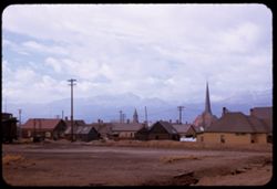
- Description:
- 25 f 4 Pola
- Subject:
- Rocky Mountains, Spires, Electric lines, Houses, Railroad cabooses, Mountains, Buildings, Shrubs, Clouds, Steeples, Elbert, Mount (Colo.), Utility poles, Chu...
- Series:
- 25-52
- Creator:
- Cushman, Charles W., 1896-1972
- Date Created:
- 1952-11-02
- Genre:
- Views
- Frame Number:
- 16
- County:
- Lake
- Abstract:
- Mt Elbert from Leadville
- Call Number:
- P06385
- City:
- Leadville
- Country:
- United States
- State/Province:
- Colorado
- Alternate Identifier:
- 2552.16
- Persistent URL:
- http://purl.dlib.indiana.edu/iudl/archives/cushman/P06385
- Holding Location:
- Bloomington - University Archives
Wells Library E460
1320 E 10th St.
Bloomington, IN 47405
Contact at archives@indiana.edu, 812-855-1127
-
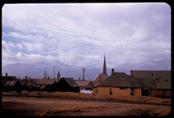
- Description:
- 25 f 5.6 Pola
- Subject:
- Rocky Mountains, Crosses, Grasses, Houses, Mountains, Churches, Clotheslines, Clouds, Railroad tracks, Elbert, Mount (Colo.), Buildings, Massive, Mount (Colo...
- Series:
- 25-52
- Creator:
- Cushman, Charles W., 1896-1972
- Date Created:
- 1952-11-02
- Genre:
- Views
- Frame Number:
- 15
- County:
- Lake
- Abstract:
- Mt Elbert from Leadville.
- Call Number:
- P06384
- City:
- Leadville
- Country:
- United States
- State/Province:
- Colorado
- Alternate Identifier:
- 2552.15
- Persistent URL:
- http://purl.dlib.indiana.edu/iudl/archives/cushman/P06384
- Holding Location:
- Bloomington - University Archives
Wells Library E460
1320 E 10th St.
Bloomington, IN 47405
Contact at archives@indiana.edu, 812-855-1127
-
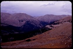
- Description:
- 25 f 4
- Subject:
- Rocks, Valleys, Roads, Trees, Mountains, Clouds, Forests, Passes (Landforms), and Loveland Pass (Colo.)
- Series:
- 25-52
- Creator:
- Cushman, Charles W., 1896-1972
- Date Created:
- 1952-11-01
- Genre:
- Landscape photographs
- Frame Number:
- 14
- Abstract:
- North from Loveland Pass.
- Call Number:
- P06383
- Country:
- United States
- State/Province:
- Colorado
- Alternate Identifier:
- 2552.14
- Persistent URL:
- http://purl.dlib.indiana.edu/iudl/archives/cushman/P06383
- Holding Location:
- Bloomington - University Archives
Wells Library E460
1320 E 10th St.
Bloomington, IN 47405
Contact at archives@indiana.edu, 812-855-1127
-
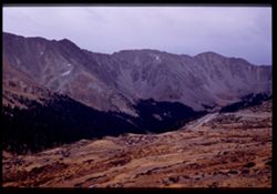
- Description:
- 25 f 3.5
- Subject:
- Passes (Landforms), Valleys, Forests, Roads, Mountains, Shrubs, Arapahoe Basin (Colo.), and Loveland Pass (Colo.)
- Series:
- 25-52
- Creator:
- Cushman, Charles W., 1896-1972
- Date Created:
- 1952-11-01
- Genre:
- Landscape photographs
- Frame Number:
- 13
- Abstract:
- From Loveland Pass 11,992 ft. - across Arapahoe Basin.
- Call Number:
- P06382
- Country:
- United States
- State/Province:
- Colorado
- Physical Description:
- Image was originally mounted in a glass enclosure. Before digitization, the image was removed and placed in a Wess Plastic, Inc. brand, 2" x 2", pl...
- Alternate Identifier:
- 2552.13
- Persistent URL:
- http://purl.dlib.indiana.edu/iudl/archives/cushman/P06382
- Holding Location:
- Bloomington - University Archives
Wells Library E460
1320 E 10th St.
Bloomington, IN 47405
Contact at archives@indiana.edu, 812-855-1127
-
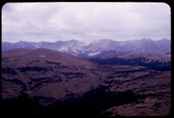
- Description:
- 50 f 5.6
- Subject:
- Rocky Mountains, Mountains, National parks & reserves, Clouds, Forests, and Rocky Mountain National Park (Colo.)
- Series:
- 25-52
- Creator:
- Cushman, Charles W., 1896-1972
- Date Created:
- 1952-11-01
- Genre:
- Landscape photographs
- Frame Number:
- 10
- Abstract:
- From highest pt. 12,183 ft. looking S.W.
- Call Number:
- P06379
- Country:
- United States
- State/Province:
- Colorado
- Alternate Identifier:
- 2552.10
- Persistent URL:
- http://purl.dlib.indiana.edu/iudl/archives/cushman/P06379
- Holding Location:
- Bloomington - University Archives
Wells Library E460
1320 E 10th St.
Bloomington, IN 47405
Contact at archives@indiana.edu, 812-855-1127
-
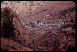
- Description:
- 25 f 4
- Subject:
- Rocks, Rocky Mountains, Valleys, Houses, Trees, Mountains, Buildings, Shrubs, Utility poles, Roads, and Cliffs
- Series:
- 25-52
- Creator:
- Cushman, Charles W., 1896-1972
- Date Created:
- 1952-11-01
- Genre:
- Cityscape photographs
- Frame Number:
- 12
- County:
- Clear Creek
- Abstract:
- Georgetown.
- Call Number:
- P06381
- City:
- Georgetown
- Country:
- United States
- State/Province:
- Colorado
- Alternate Identifier:
- 2552.12
- Persistent URL:
- http://purl.dlib.indiana.edu/iudl/archives/cushman/P06381
- Holding Location:
- Bloomington - University Archives
Wells Library E460
1320 E 10th St.
Bloomington, IN 47405
Contact at archives@indiana.edu, 812-855-1127
-
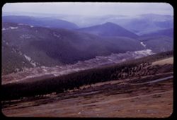
- Description:
- 50 f 6
- Subject:
- National parks & reserves, Rocky Mountains, Valleys, Rocky Mountain National Park (Colo.), Forests, Roads, Mountains, Trees, and Mists
- Series:
- 25-52
- Creator:
- Cushman, Charles W., 1896-1972
- Date Created:
- 1952-11-01
- Genre:
- Landscape photographs
- Frame Number:
- 11
- Abstract:
- Down into valley.
- Call Number:
- P06380
- Country:
- United States
- State/Province:
- Colorado
- Alternate Identifier:
- 2552.11
- Persistent URL:
- http://purl.dlib.indiana.edu/iudl/archives/cushman/P06380
- Holding Location:
- Bloomington - University Archives
Wells Library E460
1320 E 10th St.
Bloomington, IN 47405
Contact at archives@indiana.edu, 812-855-1127
-
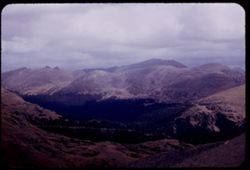
- Description:
- 50 f 8
- Subject:
- Rocky Mountains, Mummy Range (Colo.), Mummy Mountain (Colo.), Mountains, National parks & reserves, Clouds, Forests, and Rocky Mountain National Park (Co...
- Series:
- 25-52
- Creator:
- Cushman, Charles W., 1896-1972
- Date Created:
- 1952-11-01
- Genre:
- Landscape photographs
- Frame Number:
- 9
- Abstract:
- Mummy Mts from higher up.
- Call Number:
- P06378
- Country:
- United States
- State/Province:
- Colorado
- Alternate Identifier:
- 2552.9
- Persistent URL:
- http://purl.dlib.indiana.edu/iudl/archives/cushman/P06378
- Holding Location:
- Bloomington - University Archives
Wells Library E460
1320 E 10th St.
Bloomington, IN 47405
Contact at archives@indiana.edu, 812-855-1127
-
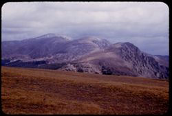
- Description:
- 50 f 7
- Subject:
- Rocky Mountains, Cliffs, Mummy Range (Colo.), Meadows, Mummy Mountain (Colo.), Mountains, National parks & reserves, Clouds, Forests, and Rocky Mountain ...
- Series:
- 25-52
- Creator:
- Cushman, Charles W., 1896-1972
- Date Created:
- 1952-11-01
- Genre:
- Landscape photographs
- Frame Number:
- 8
- Abstract:
- Mummy Mts from west.
- Call Number:
- P06377
- Country:
- United States
- State/Province:
- Colorado
- Alternate Identifier:
- 2552.8
- Persistent URL:
- http://purl.dlib.indiana.edu/iudl/archives/cushman/P06377
- Holding Location:
- Bloomington - University Archives
Wells Library E460
1320 E 10th St.
Bloomington, IN 47405
Contact at archives@indiana.edu, 812-855-1127
-
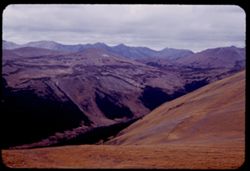
- Description:
- 50 f 5.6
- Subject:
- National parks & reserves, Rocky Mountains, Valleys, Rocky Mountain National Park (Colo.), Forests, Mountains, and Clouds
- Series:
- 25-52
- Creator:
- Cushman, Charles W., 1896-1972
- Date Created:
- 1952-11-01
- Genre:
- Landscape photographs
- Frame Number:
- 7
- Street Address:
- United States Highway
- Abstract:
- Yellow + brown.
- Call Number:
- P06376
- Country:
- United States
- State/Province:
- Colorado
- Alternate Identifier:
- 2552.7
- Persistent URL:
- http://purl.dlib.indiana.edu/iudl/archives/cushman/P06376
- Holding Location:
- Bloomington - University Archives
Wells Library E460
1320 E 10th St.
Bloomington, IN 47405
Contact at archives@indiana.edu, 812-855-1127
-
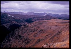
- Description:
- 50 f 8
- Subject:
- National parks & reserves, Rocky Mountains, Passes (Landforms), Rocky Mountain National Park (Colo.), Forests, Roads, Cliffs, Mountains, Rocks, and Clouds
- Series:
- 25-52
- Creator:
- Cushman, Charles W., 1896-1972
- Date Created:
- 1952-11-01
- Genre:
- Landscape photographs
- Frame Number:
- 6
- Abstract:
- View west from pass of 12,110 ft elev.
- Call Number:
- P06375
- Country:
- United States
- State/Province:
- Colorado
- Physical Description:
- Image was originally mounted in a glass enclosure. Before digitization, the image was removed and placed in a Wess Plastic, Inc. brand, 2" x 2", pl...
- Alternate Identifier:
- 2552.6
- Persistent URL:
- http://purl.dlib.indiana.edu/iudl/archives/cushman/P06375
- Holding Location:
- Bloomington - University Archives
Wells Library E460
1320 E 10th St.
Bloomington, IN 47405
Contact at archives@indiana.edu, 812-855-1127
-
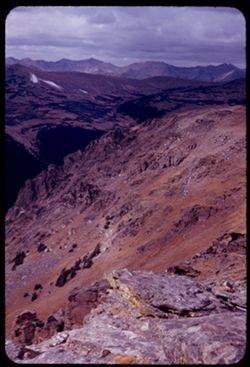
- Description:
- 50 f 8
- Subject:
- National parks & reserves, Rocky Mountains, Passes (Landforms), Rocky Mountain National Park (Colo.), Forests, Cliffs, Mountains, Shrubs, Trees, Rocks, a...
- Series:
- 25-52
- Creator:
- Cushman, Charles W., 1896-1972
- Date Created:
- 1952-11-01
- Genre:
- Landscape photographs
- Frame Number:
- 5
- Abstract:
- View west from pass of 12,110 ft elev.
- Call Number:
- P06374
- Country:
- United States
- State/Province:
- Colorado
- Alternate Identifier:
- 2552.5
- Persistent URL:
- http://purl.dlib.indiana.edu/iudl/archives/cushman/P06374
- Holding Location:
- Bloomington - University Archives
Wells Library E460
1320 E 10th St.
Bloomington, IN 47405
Contact at archives@indiana.edu, 812-855-1127
-
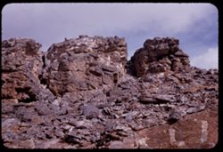
- Description:
- 50 f 8
- Subject:
- Rocks, Rocky Mountains, Boulders, Rock formations, Passes (Landforms), Rocky Mountain National Park (Colo.), and National parks & reserves
- Series:
- 25-52
- Creator:
- Cushman, Charles W., 1896-1972
- Date Created:
- 1952-11-01
- Genre:
- Snapshots
- Frame Number:
- 4
- Abstract:
- Rocks above pass at 12,110 ft. elev.
- Call Number:
- P06373
- Country:
- United States
- State/Province:
- Colorado
- Alternate Identifier:
- 2552.4
- Persistent URL:
- http://purl.dlib.indiana.edu/iudl/archives/cushman/P06373
- Holding Location:
- Bloomington - University Archives
Wells Library E460
1320 E 10th St.
Bloomington, IN 47405
Contact at archives@indiana.edu, 812-855-1127