
Search Constraints
You searched for:
Subject
Rock formations
Remove constraint Subject: Rock formations
State/Province
Colorado
Remove constraint State/Province: Colorado
« Previous |
1 - 50 of 115
|
Next »
Search Results
-
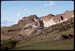
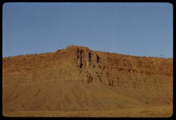
- Description:
- 100 f 11 tl
- Subject:
- Rocks, Cliffs, Grazing, Trees, Mining, Cattle, Mountains, Rock formations, Clouds, Utility poles, and Roads
- Series:
- 9-66
- Creator:
- Cushman, Charles W., 1896-1972
- Date Created:
- 1966-06-14
- Genre:
- Landscape photographs
- Frame Number:
- 23
- Street Address:
- Colorado State Highway 93
- County:
- Jefferson and Boulder
- Call Number:
- P15426
- City:
- Golden and Boulder
- Country:
- United States
- State/Province:
- Colorado
- Alternate Identifier:
- 966.23
- Persistent URL:
- http://purl.dlib.indiana.edu/iudl/archives/cushman/P15426
- Holding Location:
- Bloomington - University Archives
Wells Library E460
1320 E 10th St.
Bloomington, IN 47405
Contact at archives@indiana.edu, 812-855-1127
-
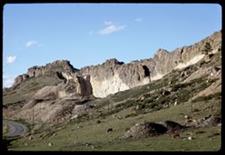
- Description:
- 100 f 11 tl
- Subject:
- Rocks, Cliffs, Grazing, Mining, Cattle, Mountains, Rock formations, Utility poles, Roads, and Shrubs
- Series:
- 9-66
- Creator:
- Cushman, Charles W., 1896-1972
- Date Created:
- 1966-06-14
- Genre:
- Landscape photographs
- Frame Number:
- 22
- Street Address:
- Colorado State Highway 93
- County:
- Jefferson and Boulder
- Call Number:
- P15425
- City:
- Golden and Boulder
- Country:
- United States
- State/Province:
- Colorado
- Alternate Identifier:
- 966.22
- Persistent URL:
- http://purl.dlib.indiana.edu/iudl/archives/cushman/P15425
- Holding Location:
- Bloomington - University Archives
Wells Library E460
1320 E 10th St.
Bloomington, IN 47405
Contact at archives@indiana.edu, 812-855-1127
-
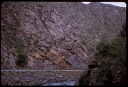
- Description:
- 100 f 4.5
- Subject:
- Canyons, Roads, Cliffs, Trees, Rocks, Clear Creek (Clear Creek County, Colo.), Rivers, Clear Creek Canyon (Colo.), and Rock formations
- Series:
- 9-66
- Creator:
- Cushman, Charles W., 1896-1972
- Date Created:
- 1966-06-13
- Genre:
- Landscape photographs
- Frame Number:
- 14
- County:
- Clear Creek
- Call Number:
- P15417
- Country:
- United States
- State/Province:
- Colorado
- Alternate Identifier:
- 966.14
- Persistent URL:
- http://purl.dlib.indiana.edu/iudl/archives/cushman/P15417
- Holding Location:
- Bloomington - University Archives
Wells Library E460
1320 E 10th St.
Bloomington, IN 47405
Contact at archives@indiana.edu, 812-855-1127
-
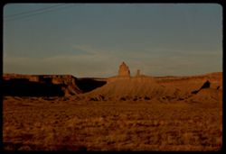
- Description:
- 100 f 16 TL
- Subject:
- Erosion, Plains, Canyons, Grasses, Mesas, and Rock formations
- Series:
- 36-65
- Creator:
- Cushman, Charles W., 1896-1972
- Date Created:
- 1965-10-07
- Genre:
- Landscape photographs
- Frame Number:
- 22
- Street Address:
- United States Highway 666
- County:
- Montezuma
- Abstract:
- Squaw + papoose along Hwy 666.
- Call Number:
- P15090
- City:
- Cortez
- Country:
- United States
- State/Province:
- Colorado
- Alternate Identifier:
- 3665.22
- Persistent URL:
- http://purl.dlib.indiana.edu/iudl/archives/cushman/P15090
- Holding Location:
- Bloomington - University Archives
Wells Library E460
1320 E 10th St.
Bloomington, IN 47405
Contact at archives@indiana.edu, 812-855-1127
-
- Description:
- 100 f 16 TL
- Subject:
- Erosion, Sand, Buttes, Rock formations, Mesas, and Cliffs
- Series:
- 36-65
- Creator:
- Cushman, Charles W., 1896-1972
- Date Created:
- 1965-10-07
- Genre:
- Landscape photographs
- Frame Number:
- 21
- Street Address:
- United States Highway 666
- County:
- Montezuma
- Abstract:
- Sad rock.
- Call Number:
- P15089
- City:
- Cortez
- Country:
- United States
- State/Province:
- Colorado
- Alternate Identifier:
- 3665.21
- Persistent URL:
- http://purl.dlib.indiana.edu/iudl/archives/cushman/P15089
- Holding Location:
- Bloomington - University Archives
Wells Library E460
1320 E 10th St.
Bloomington, IN 47405
Contact at archives@indiana.edu, 812-855-1127
-
- Description:
- 100 f 16 TL
- Subject:
- Erosion, Cliffs, Buttes, Rock formations, and Mesas
- Series:
- 36-65
- Creator:
- Cushman, Charles W., 1896-1972
- Date Created:
- 1965-10-07
- Genre:
- Landscape photographs
- Frame Number:
- 20
- Street Address:
- United States Highway 666
- County:
- Montezuma
- Abstract:
- Sad rock
- Call Number:
- P15088
- City:
- Cortez
- Country:
- United States
- State/Province:
- Colorado
- Alternate Identifier:
- 3665.20
- Persistent URL:
- http://purl.dlib.indiana.edu/iudl/archives/cushman/P15088
- Holding Location:
- Bloomington - University Archives
Wells Library E460
1320 E 10th St.
Bloomington, IN 47405
Contact at archives@indiana.edu, 812-855-1127
-
- Description:
- 100 f 16 TL
- Subject:
- Plains, Cliffs, Buttes, Rock formations, Mesas, and Grasses
- Series:
- 36-65
- Creator:
- Cushman, Charles W., 1896-1972
- Date Created:
- 1965-10-07
- Genre:
- Landscape photographs
- Frame Number:
- 19
- Street Address:
- United States Highway 666
- County:
- Montezuma
- Abstract:
- Sad rock.
- Call Number:
- P15087
- City:
- Cortez
- Country:
- United States
- State/Province:
- Colorado
- Alternate Identifier:
- 3665.19
- Persistent URL:
- http://purl.dlib.indiana.edu/iudl/archives/cushman/P15087
- Holding Location:
- Bloomington - University Archives
Wells Library E460
1320 E 10th St.
Bloomington, IN 47405
Contact at archives@indiana.edu, 812-855-1127
-
- Description:
- 100 f 11 TL
- Subject:
- Erosion, Cliffs, Electric lines, Rock formations, Mesas, and Sand
- Series:
- 36-65
- Creator:
- Cushman, Charles W., 1896-1972
- Date Created:
- 1965-10-07
- Genre:
- Landscape photographs
- Frame Number:
- 18
- Street Address:
- United States Highway 666
- County:
- Montezuma
- Abstract:
- Corner of fine Mesa in Colo. from N.W.
- Call Number:
- P15086
- City:
- Cortez
- Country:
- United States
- State/Province:
- Colorado
- Alternate Identifier:
- 3665.18
- Persistent URL:
- http://purl.dlib.indiana.edu/iudl/archives/cushman/P15086
- Holding Location:
- Bloomington - University Archives
Wells Library E460
1320 E 10th St.
Bloomington, IN 47405
Contact at archives@indiana.edu, 812-855-1127
-
- Description:
- 100 f 11 TL
- Subject:
- Erosion, Sand, Rock formations, Mesas, and Cliffs
- Series:
- 36-65
- Creator:
- Cushman, Charles W., 1896-1972
- Date Created:
- 1965-10-07
- Genre:
- Landscape photographs
- Frame Number:
- 17
- Street Address:
- United States Highway 666
- County:
- Montezuma
- Abstract:
- Corner of fine Mesa in Colo.
- Call Number:
- P15085
- City:
- Cortez
- Country:
- United States
- State/Province:
- Colorado
- Alternate Identifier:
- 3665.17
- Persistent URL:
- http://purl.dlib.indiana.edu/iudl/archives/cushman/P15085
- Holding Location:
- Bloomington - University Archives
Wells Library E460
1320 E 10th St.
Bloomington, IN 47405
Contact at archives@indiana.edu, 812-855-1127
-
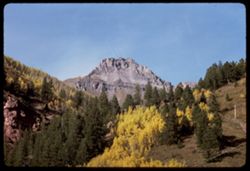
- Description:
- 100 f 11 TL
- Subject:
- Forests, Cliffs, San Juan Mountains (Colo. and N.M.), Mountains, Trees, and Rock formations
- Series:
- 36-65
- Creator:
- Cushman, Charles W., 1896-1972
- Date Created:
- 1965-10-05
- Genre:
- Landscape photographs
- Frame Number:
- 5
- County:
- San Miguel
- Abstract:
- Up from Telluride.
- Call Number:
- P15073
- City:
- Telluride
- Country:
- United States
- State/Province:
- Colorado
- Alternate Identifier:
- 3665.5
- Persistent URL:
- http://purl.dlib.indiana.edu/iudl/archives/cushman/P15073
- Holding Location:
- Bloomington - University Archives
Wells Library E460
1320 E 10th St.
Bloomington, IN 47405
Contact at archives@indiana.edu, 812-855-1127
-
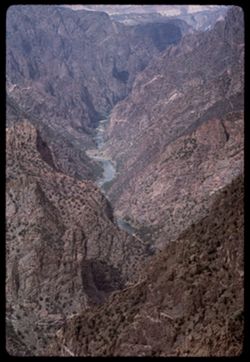
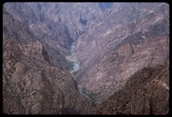
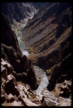
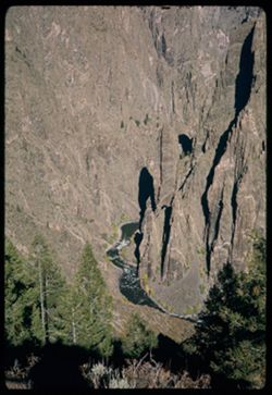
- Description:
- 100 f 13 TL
- Subject:
- Black Canyon of the Gunnison National Park (Colo.), Canyons, Cliffs, Mountains, Black Canyon of the Gunnison (Colo.), Rock formations, National parks & r...
- Series:
- 35-65
- Creator:
- Cushman, Charles W., 1896-1972
- Date Created:
- 1965-10-05
- Genre:
- Landscape photographs
- Frame Number:
- 30
- County:
- Montrose
- Abstract:
- Downstream from Sunset View
- Call Number:
- P15060
- Country:
- United States
- State/Province:
- Colorado
- Alternate Identifier:
- 3565.30
- Persistent URL:
- http://purl.dlib.indiana.edu/iudl/archives/cushman/P15060
- Holding Location:
- Bloomington - University Archives
Wells Library E460
1320 E 10th St.
Bloomington, IN 47405
Contact at archives@indiana.edu, 812-855-1127
-
- Description:
- 100 f 13
- Subject:
- Black Canyon of the Gunnison National Park (Colo.), Canyons, Cliffs, Mountains, Black Canyon of the Gunnison (Colo.), Rock formations, National parks & r...
- Series:
- 35-65
- Creator:
- Cushman, Charles W., 1896-1972
- Date Created:
- 1965-10-05
- Genre:
- Landscape photographs
- Frame Number:
- 28
- County:
- Montrose
- Abstract:
- Downstream from Sunset View.
- Call Number:
- P15058
- Country:
- United States
- State/Province:
- Colorado
- Alternate Identifier:
- 3565.28
- Persistent URL:
- http://purl.dlib.indiana.edu/iudl/archives/cushman/P15058
- Holding Location:
- Bloomington - University Archives
Wells Library E460
1320 E 10th St.
Bloomington, IN 47405
Contact at archives@indiana.edu, 812-855-1127
-
- Description:
- 100 f 11 TL
- Subject:
- Canyons, Cliffs, Black Canyon of the Gunnison National Park (Colo.), Mountains, National parks & reserves, Black Canyon of the Gunnison (Colo.), Rivers, ...
- Series:
- 35-65
- Creator:
- Cushman, Charles W., 1896-1972
- Date Created:
- 1965-10-05
- Genre:
- Landscape photographs
- Frame Number:
- 29
- County:
- Montrose
- Abstract:
- Downstream from Sunset View
- Call Number:
- P15059
- Country:
- United States
- State/Province:
- Colorado
- Alternate Identifier:
- 3565.29
- Persistent URL:
- http://purl.dlib.indiana.edu/iudl/archives/cushman/P15059
- Holding Location:
- Bloomington - University Archives
Wells Library E460
1320 E 10th St.
Bloomington, IN 47405
Contact at archives@indiana.edu, 812-855-1127
-
- Description:
- 100 f 11
- Subject:
- Canyons, Cliffs, Black Canyon of the Gunnison National Park (Colo.), Mountains, Rock formations, Black Canyon of the Gunnison (Colo.), Rivers, and National p...
- Series:
- 35-65
- Creator:
- Cushman, Charles W., 1896-1972
- Date Created:
- 1965-10-05
- Genre:
- Landscape photographs
- Frame Number:
- 27
- County:
- Montrose
- Abstract:
- Downstream from Sunset View.
- Call Number:
- P15057
- Country:
- United States
- State/Province:
- Colorado
- Alternate Identifier:
- 3565.27
- Persistent URL:
- http://purl.dlib.indiana.edu/iudl/archives/cushman/P15057
- Holding Location:
- Bloomington - University Archives
Wells Library E460
1320 E 10th St.
Bloomington, IN 47405
Contact at archives@indiana.edu, 812-855-1127
-
- Description:
- 100 f 9
- Subject:
- Rocks, Canyons, Cliffs, Black Canyon of the Gunnison National Park (Colo.), Rock formations, Black Canyon of the Gunnison (Colo.), Rivers, and National parks...
- Series:
- 35-65
- Creator:
- Cushman, Charles W., 1896-1972
- Date Created:
- 1965-10-05
- Genre:
- Landscape photographs
- Frame Number:
- 26
- County:
- Montrose
- Abstract:
- Down into Chasm.
- Call Number:
- P15056
- Country:
- United States
- State/Province:
- Colorado
- Alternate Identifier:
- 3565.26
- Persistent URL:
- http://purl.dlib.indiana.edu/iudl/archives/cushman/P15056
- Holding Location:
- Bloomington - University Archives
Wells Library E460
1320 E 10th St.
Bloomington, IN 47405
Contact at archives@indiana.edu, 812-855-1127
-
- Description:
- 100 f 11
- Subject:
- National parks & reserves, Canyons, Cliffs, Black Canyon of the Gunnison (Colo.), Rock formations, and Black Canyon of the Gunnison National Park (Colo.)
- Series:
- 35-65
- Creator:
- Cushman, Charles W., 1896-1972
- Date Created:
- 1965-10-05
- Genre:
- Landscape photographs
- Frame Number:
- 25
- County:
- Montrose
- Abstract:
- From Chasm view.
- Call Number:
- P15055
- Country:
- United States
- State/Province:
- Colorado
- Alternate Identifier:
- 3565.25
- Persistent URL:
- http://purl.dlib.indiana.edu/iudl/archives/cushman/P15055
- Holding Location:
- Bloomington - University Archives
Wells Library E460
1320 E 10th St.
Bloomington, IN 47405
Contact at archives@indiana.edu, 812-855-1127
-
- Description:
- 100 f 11
- Subject:
- Walls, Canyons, Cliffs, Black Canyon of the Gunnison National Park (Colo.), Rock formations, Black Canyon of the Gunnison (Colo.), and National parks & r...
- Series:
- 35-65
- Creator:
- Cushman, Charles W., 1896-1972
- Date Created:
- 1965-10-05
- Genre:
- Landscape photographs
- Frame Number:
- 24
- County:
- Montrose
- Abstract:
- From Chasm view.
- Call Number:
- P15054
- Country:
- United States
- State/Province:
- Colorado
- Alternate Identifier:
- 3565.24
- Persistent URL:
- http://purl.dlib.indiana.edu/iudl/archives/cushman/P15054
- Holding Location:
- Bloomington - University Archives
Wells Library E460
1320 E 10th St.
Bloomington, IN 47405
Contact at archives@indiana.edu, 812-855-1127
-
- Description:
- 100 f 13
- Subject:
- Canyons, Cliffs, Black Canyon of the Gunnison National Park (Colo.), National parks & reserves, Black Canyon of the Gunnison (Colo.), and Rock formations
- Series:
- 35-65
- Creator:
- Cushman, Charles W., 1896-1972
- Date Created:
- 1965-10-05
- Genre:
- Landscape photographs
- Frame Number:
- 23
- County:
- Montrose
- Abstract:
- From cross canyon overlk.
- Call Number:
- P15053
- Country:
- United States
- State/Province:
- Colorado
- Alternate Identifier:
- 3565.23
- Persistent URL:
- http://purl.dlib.indiana.edu/iudl/archives/cushman/P15053
- Holding Location:
- Bloomington - University Archives
Wells Library E460
1320 E 10th St.
Bloomington, IN 47405
Contact at archives@indiana.edu, 812-855-1127
-
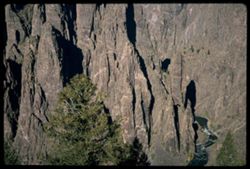
- Description:
- 100 f 13
- Subject:
- Black Canyon of the Gunnison National Park (Colo.), Canyons, Cliffs, Black Canyon of the Gunnison (Colo.), Rock formations, and National parks & reserves
- Series:
- 35-65
- Creator:
- Cushman, Charles W., 1896-1972
- Date Created:
- 1965-10-05
- Genre:
- Landscape photographs
- Frame Number:
- 21
- County:
- Montrose
- Abstract:
- From cross canyon overlk.
- Call Number:
- P15051
- Country:
- United States
- State/Province:
- Colorado
- Alternate Identifier:
- 3565.21
- Persistent URL:
- http://purl.dlib.indiana.edu/iudl/archives/cushman/P15051
- Holding Location:
- Bloomington - University Archives
Wells Library E460
1320 E 10th St.
Bloomington, IN 47405
Contact at archives@indiana.edu, 812-855-1127
-
- Description:
- 100 f 11
- Subject:
- National parks & reserves, Canyons, Cliffs, Mountains, Black Canyon of the Gunnison (Colo.), Rock formations, and Black Canyon of the Gunnison National P...
- Series:
- 35-65
- Creator:
- Cushman, Charles W., 1896-1972
- Date Created:
- 1965-10-05
- Genre:
- Landscape photographs
- Frame Number:
- 22
- County:
- Montrose
- Abstract:
- From cross canyon overlk.
- Call Number:
- P15052
- Country:
- United States
- State/Province:
- Colorado
- Alternate Identifier:
- 3565.22
- Persistent URL:
- http://purl.dlib.indiana.edu/iudl/archives/cushman/P15052
- Holding Location:
- Bloomington - University Archives
Wells Library E460
1320 E 10th St.
Bloomington, IN 47405
Contact at archives@indiana.edu, 812-855-1127
-
- Description:
- 100 f 13
- Subject:
- National parks & reserves, Canyons, Cliffs, Black Canyon of the Gunnison (Colo.), Rock formations, and Black Canyon of the Gunnison National Park (Colo.)
- Series:
- 35-65
- Creator:
- Cushman, Charles W., 1896-1972
- Date Created:
- 1965-10-05
- Genre:
- Landscape photographs
- Frame Number:
- 20
- County:
- Montrose
- Abstract:
- From cross canyon overlk.
- Call Number:
- P15050
- Country:
- United States
- State/Province:
- Colorado
- Alternate Identifier:
- 3565.20
- Persistent URL:
- http://purl.dlib.indiana.edu/iudl/archives/cushman/P15050
- Holding Location:
- Bloomington - University Archives
Wells Library E460
1320 E 10th St.
Bloomington, IN 47405
Contact at archives@indiana.edu, 812-855-1127
-
- Description:
- 200 f 11
- Subject:
- National parks & reserves, Canyons, Cliffs, Black Canyon of the Gunnison (Colo.), Rock formations, and Black Canyon of the Gunnison National Park (Colo.)
- Series:
- 35-65
- Creator:
- Cushman, Charles W., 1896-1972
- Date Created:
- 1965-10-05
- Genre:
- Landscape photographs
- Frame Number:
- 19
- County:
- Montrose
- Abstract:
- From cross canyon overlk.
- Call Number:
- P15049
- Country:
- United States
- State/Province:
- Colorado
- Alternate Identifier:
- 3565.19
- Persistent URL:
- http://purl.dlib.indiana.edu/iudl/archives/cushman/P15049
- Holding Location:
- Bloomington - University Archives
Wells Library E460
1320 E 10th St.
Bloomington, IN 47405
Contact at archives@indiana.edu, 812-855-1127
-
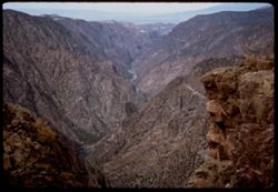
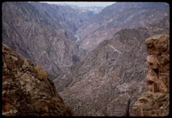
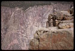
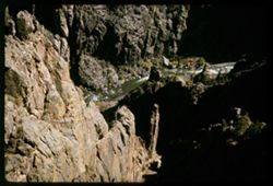
- Description:
- 100 f 9
- Subject:
- Black Canyon of the Gunnison National Park (Colo.), Pulpit Rock (Colo.), Canyons, Cliffs, Mountains, Black Canyon of the Gunnison (Colo.), Rivers, National p...
- Series:
- 35-65
- Creator:
- Cushman, Charles W., 1896-1972
- Date Created:
- 1965-10-05
- Genre:
- Landscape photographs
- Frame Number:
- 17
- County:
- Montrose
- Abstract:
- From Pulpit Rock Overlook.
- Call Number:
- P15047
- Country:
- United States
- State/Province:
- Colorado
- Alternate Identifier:
- 3565.17
- Persistent URL:
- http://purl.dlib.indiana.edu/iudl/archives/cushman/P15047
- Holding Location:
- Bloomington - University Archives
Wells Library E460
1320 E 10th St.
Bloomington, IN 47405
Contact at archives@indiana.edu, 812-855-1127
-
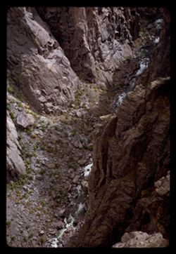
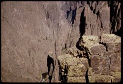
- Description:
- 100 f 11
- Subject:
- Black Canyon of the Gunnison National Park (Colo.), Canyons, Cliffs, Black Canyon of the Gunnison (Colo.), Rivers, National parks & reserves, and Rock fo...
- Series:
- 35-65
- Creator:
- Cushman, Charles W., 1896-1972
- Date Created:
- 1965-10-05
- Genre:
- Landscape photographs
- Frame Number:
- 15
- County:
- Montrose
- Abstract:
- Straight down.
- Call Number:
- P15045
- Country:
- United States
- State/Province:
- Colorado
- Alternate Identifier:
- 3565.15
- Persistent URL:
- http://purl.dlib.indiana.edu/iudl/archives/cushman/P15045
- Holding Location:
- Bloomington - University Archives
Wells Library E460
1320 E 10th St.
Bloomington, IN 47405
Contact at archives@indiana.edu, 812-855-1127
-
- Description:
- 100 f 11
- Subject:
- Canyons, Cliffs, Black Canyon of the Gunnison National Park (Colo.), Pulpit Rock (Colo.), Mountains, National parks & reserves, Rapids, Black Canyon of t...
- Series:
- 35-65
- Creator:
- Cushman, Charles W., 1896-1972
- Date Created:
- 1965-10-05
- Genre:
- Landscape photographs
- Frame Number:
- 16
- County:
- Montrose
- Abstract:
- From Pulpit Rock Overlook.
- Call Number:
- P15046
- Country:
- United States
- State/Province:
- Colorado
- Alternate Identifier:
- 3565.16
- Persistent URL:
- http://purl.dlib.indiana.edu/iudl/archives/cushman/P15046
- Holding Location:
- Bloomington - University Archives
Wells Library E460
1320 E 10th St.
Bloomington, IN 47405
Contact at archives@indiana.edu, 812-855-1127
-
- Description:
- 100 f 16
- Subject:
- Cliffs, Black Canyon of the Gunnison National Park (Colo.), Pulpit Rock (Colo.), Rock formations, Black Canyon of the Gunnison (Colo.), and National parks &a...
- Series:
- 35-65
- Creator:
- Cushman, Charles W., 1896-1972
- Date Created:
- 1965-10-05
- Genre:
- Landscape photographs
- Frame Number:
- 18
- County:
- Montrose
- Abstract:
- From cross canyon overlk.
- Call Number:
- P15048
- Country:
- United States
- State/Province:
- Colorado
- Alternate Identifier:
- 3565.18
- Persistent URL:
- http://purl.dlib.indiana.edu/iudl/archives/cushman/P15048
- Holding Location:
- Bloomington - University Archives
Wells Library E460
1320 E 10th St.
Bloomington, IN 47405
Contact at archives@indiana.edu, 812-855-1127
-
- Description:
- 100 f 11
- Subject:
- Black Canyon of the Gunnison National Park (Colo.), Canyons, Cliffs, Trees, Black Canyon of the Gunnison (Colo.), Rock formations, National parks & reser...
- Series:
- 35-65
- Creator:
- Cushman, Charles W., 1896-1972
- Date Created:
- 1965-10-05
- Genre:
- Landscape photographs
- Frame Number:
- 14
- County:
- Montrose
- Abstract:
- Straight down.
- Call Number:
- P15044
- Country:
- United States
- State/Province:
- Colorado
- Alternate Identifier:
- 3565.14
- Persistent URL:
- http://purl.dlib.indiana.edu/iudl/archives/cushman/P15044
- Holding Location:
- Bloomington - University Archives
Wells Library E460
1320 E 10th St.
Bloomington, IN 47405
Contact at archives@indiana.edu, 812-855-1127
-
- Description:
- 100 f 13
- Subject:
- Canyons, Cliffs, Black Canyon of the Gunnison National Park (Colo.), National parks & reserves, Black Canyon of the Gunnison (Colo.), Rivers, and Rock fo...
- Series:
- 35-65
- Creator:
- Cushman, Charles W., 1896-1972
- Date Created:
- 1965-10-05
- Genre:
- Landscape photographs
- Frame Number:
- 12
- County:
- Montrose
- Abstract:
- Black Canyon of the Gunnison.
- Call Number:
- P15042
- Country:
- United States
- State/Province:
- Colorado
- Alternate Identifier:
- 3565.12
- Persistent URL:
- http://purl.dlib.indiana.edu/iudl/archives/cushman/P15042
- Holding Location:
- Bloomington - University Archives
Wells Library E460
1320 E 10th St.
Bloomington, IN 47405
Contact at archives@indiana.edu, 812-855-1127
-
- Description:
- 200 f 11
- Subject:
- Canyons, Cliffs, Black Canyon of the Gunnison National Park (Colo.), Trees, National parks & reserves, Black Canyon of the Gunnison (Colo.), Rivers, and ...
- Series:
- 35-65
- Creator:
- Cushman, Charles W., 1896-1972
- Date Created:
- 1965-10-05
- Genre:
- Landscape photographs
- Frame Number:
- 13
- County:
- Montrose
- Abstract:
- Down + down stream.
- Call Number:
- P15043
- Country:
- United States
- State/Province:
- Colorado
- Alternate Identifier:
- 3565.13
- Persistent URL:
- http://purl.dlib.indiana.edu/iudl/archives/cushman/P15043
- Holding Location:
- Bloomington - University Archives
Wells Library E460
1320 E 10th St.
Bloomington, IN 47405
Contact at archives@indiana.edu, 812-855-1127
-
- Description:
- 100 f 13
- Subject:
- Canyons, Cliffs, Black Canyon of the Gunnison National Park (Colo.), National parks & reserves, Black Canyon of the Gunnison (Colo.), Rivers, and Rock fo...
- Series:
- 35-65
- Creator:
- Cushman, Charles W., 1896-1972
- Date Created:
- 1965-10-05
- Genre:
- Landscape photographs
- Frame Number:
- 11
- County:
- Montrose
- Abstract:
- Black Canyon of the Gunnison.
- Call Number:
- P15041
- Country:
- United States
- State/Province:
- Colorado
- Alternate Identifier:
- 3565.11
- Persistent URL:
- http://purl.dlib.indiana.edu/iudl/archives/cushman/P15041
- Holding Location:
- Bloomington - University Archives
Wells Library E460
1320 E 10th St.
Bloomington, IN 47405
Contact at archives@indiana.edu, 812-855-1127
-
- Description:
- 100 f 11
- Subject:
- Canyons, Cliffs, Black Canyon of the Gunnison National Park (Colo.), Trees, Mountains, National parks & reserves, Black Canyon of the Gunnison (Colo.), R...
- Series:
- 35-65
- Creator:
- Cushman, Charles W., 1896-1972
- Date Created:
- 1965-10-05
- Genre:
- Landscape photographs
- Frame Number:
- 9
- County:
- Montrose
- Abstract:
- Black Canyon of the Gunnison.
- Call Number:
- P15039
- Country:
- United States
- State/Province:
- Colorado
- Alternate Identifier:
- 3565.9
- Persistent URL:
- http://purl.dlib.indiana.edu/iudl/archives/cushman/P15039
- Holding Location:
- Bloomington - University Archives
Wells Library E460
1320 E 10th St.
Bloomington, IN 47405
Contact at archives@indiana.edu, 812-855-1127
-
- Description:
- 100 f 11
- Subject:
- Canyons, Cliffs, Black Canyon of the Gunnison National Park (Colo.), Rock formations, Black Canyon of the Gunnison (Colo.), and National parks & reserves
- Series:
- 35-65
- Creator:
- Cushman, Charles W., 1896-1972
- Date Created:
- 1965-10-05
- Genre:
- Landscape photographs
- Frame Number:
- 10
- County:
- Montrose
- Abstract:
- Black Canyon of the Gunnison.
- Call Number:
- P15040
- Country:
- United States
- State/Province:
- Colorado
- Alternate Identifier:
- 3565.10
- Persistent URL:
- http://purl.dlib.indiana.edu/iudl/archives/cushman/P15040
- Holding Location:
- Bloomington - University Archives
Wells Library E460
1320 E 10th St.
Bloomington, IN 47405
Contact at archives@indiana.edu, 812-855-1127
-
- Description:
- 100 f 13
- Subject:
- Canyons, Cliffs, Black Canyon of the Gunnison National Park (Colo.), Trees, Rock formations, Black Canyon of the Gunnison (Colo.), Rivers, and National parks...
- Series:
- 35-65
- Creator:
- Cushman, Charles W., 1896-1972
- Date Created:
- 1965-10-05
- Genre:
- Landscape photographs
- Frame Number:
- 8
- County:
- Montrose
- Abstract:
- Black Canyon of the Gunnison.
- Call Number:
- P15038
- Country:
- United States
- State/Province:
- Colorado
- Alternate Identifier:
- 3565.8
- Persistent URL:
- http://purl.dlib.indiana.edu/iudl/archives/cushman/P15038
- Holding Location:
- Bloomington - University Archives
Wells Library E460
1320 E 10th St.
Bloomington, IN 47405
Contact at archives@indiana.edu, 812-855-1127
-
- Description:
- 200 f 11
- Subject:
- Canyons, Cliffs, Black Canyon of the Gunnison National Park (Colo.), Trees, Mountains, Rock formations, Black Canyon of the Gunnison (Colo.), and Rivers
- Series:
- 35-65
- Creator:
- Cushman, Charles W., 1896-1972
- Date Created:
- 1965-10-05
- Genre:
- Landscape photographs
- Frame Number:
- 7
- County:
- Montrose
- Abstract:
- Black Canyon of the Gunnison.
- Call Number:
- P15037
- Country:
- United States
- State/Province:
- Colorado
- Alternate Identifier:
- 3565.7
- Persistent URL:
- http://purl.dlib.indiana.edu/iudl/archives/cushman/P15037
- Holding Location:
- Bloomington - University Archives
Wells Library E460
1320 E 10th St.
Bloomington, IN 47405
Contact at archives@indiana.edu, 812-855-1127
-
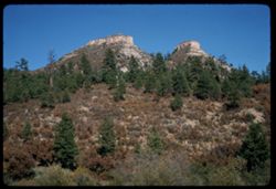
- Description:
- 100 f 13 sl
- Subject:
- Trees, Mountains, Rock formations, and Shrubs
- Series:
- 34-65
- Creator:
- Cushman, Charles W., 1896-1972
- Date Created:
- 1965-10-03
- Genre:
- Landscape photographs
- Frame Number:
- 15
- County:
- La Plata
- Abstract:
- 2 truncated pyramids w. of Durango
- Call Number:
- P15007
- City:
- Durango
- Country:
- United States
- State/Province:
- Colorado
- Alternate Identifier:
- 3465.15
- Persistent URL:
- http://purl.dlib.indiana.edu/iudl/archives/cushman/P15007
- Holding Location:
- Bloomington - University Archives
Wells Library E460
1320 E 10th St.
Bloomington, IN 47405
Contact at archives@indiana.edu, 812-855-1127
-
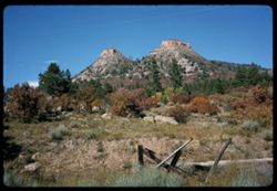
- Description:
- 100 f 13 sl
- Subject:
- Grasses, Trees, Mountains, Fences, Shrubs, and Rock formations
- Series:
- 34-65
- Creator:
- Cushman, Charles W., 1896-1972
- Date Created:
- 1965-10-03
- Genre:
- Landscape photographs
- Frame Number:
- 14
- County:
- La Plata
- Abstract:
- 2 truncated pyramids w. of Durango
- Call Number:
- P15006
- City:
- Durango
- Country:
- United States
- State/Province:
- Colorado
- Alternate Identifier:
- 3465.14
- Persistent URL:
- http://purl.dlib.indiana.edu/iudl/archives/cushman/P15006
- Holding Location:
- Bloomington - University Archives
Wells Library E460
1320 E 10th St.
Bloomington, IN 47405
Contact at archives@indiana.edu, 812-855-1127
-
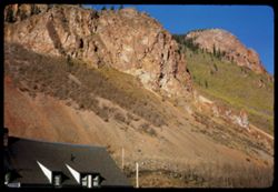
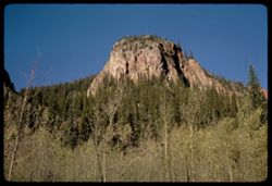
- Description:
- 100 f 13
- Subject:
- Houses, Trees, Roofs, Mountains, Rock formations, Dormers, and Cliffs
- Series:
- 33-65
- Creator:
- Cushman, Charles W., 1896-1972
- Date Created:
- 1965-10-02
- Genre:
- Landscape photographs
- Frame Number:
- 31
- Street Address:
- Molas Pass
- County:
- San Juan and La Plata
- Abstract:
- Looking up
- Call Number:
- P14986
- City:
- Durango
- Country:
- United States
- State/Province:
- Colorado
- Alternate Identifier:
- 3365.31
- Persistent URL:
- http://purl.dlib.indiana.edu/iudl/archives/cushman/P14986
- Holding Location:
- Bloomington - University Archives
Wells Library E460
1320 E 10th St.
Bloomington, IN 47405
Contact at archives@indiana.edu, 812-855-1127
-
- Description:
- 100 f 11 sl
- Subject:
- Cliffs, Trees, Tree limbs, Mountains, Rock formations, and Forests
- Series:
- 33-65
- Creator:
- Cushman, Charles W., 1896-1972
- Date Created:
- 1965-10-02
- Genre:
- Landscape photographs
- Frame Number:
- 28
- Street Address:
- United States Highway 550
- County:
- La Plata and Ouray
- Abstract:
- Pink [mountain]
- Call Number:
- P14983
- City:
- Durango and Ouray
- Country:
- United States
- State/Province:
- Colorado
- Alternate Identifier:
- 3365.28
- Persistent URL:
- http://purl.dlib.indiana.edu/iudl/archives/cushman/P14983
- Holding Location:
- Bloomington - University Archives
Wells Library E460
1320 E 10th St.
Bloomington, IN 47405
Contact at archives@indiana.edu, 812-855-1127
-
- Description:
- 100 f 11 sl
- Subject:
- Rocks, Valleys, Cliffs, Trees, Mountains, Fences, Rock formations, and Forests
- Series:
- 32-65
- Creator:
- Cushman, Charles W., 1896-1972
- Date Created:
- 1965-10-02
- Genre:
- Landscape photographs
- Frame Number:
- 37
- Street Address:
- United States Highway 550
- County:
- San Juan and La Plata
- Abstract:
- Maybe [Hernora] cliffs
- Call Number:
- P14955
- City:
- Durango and Silverton
- Country:
- United States
- State/Province:
- Colorado
- Alternate Identifier:
- 3265.37
- Persistent URL:
- http://purl.dlib.indiana.edu/iudl/archives/cushman/P14955
- Holding Location:
- Bloomington - University Archives
Wells Library E460
1320 E 10th St.
Bloomington, IN 47405
Contact at archives@indiana.edu, 812-855-1127
-
- Description:
- 100 f 11 sl
- Subject:
- Valleys, Cliffs, Trees, Mountains, Rock formations, and Forests
- Series:
- 32-65
- Creator:
- Cushman, Charles W., 1896-1972
- Date Created:
- 1965-10-02
- Genre:
- Landscape photographs
- Frame Number:
- 36
- Street Address:
- United States Highway 550
- County:
- San Juan and La Plata
- Abstract:
- Cliffs and fall colors
- Call Number:
- P14954
- City:
- Durango and Silverton
- Country:
- United States
- State/Province:
- Colorado
- Alternate Identifier:
- 3265.36
- Persistent URL:
- http://purl.dlib.indiana.edu/iudl/archives/cushman/P14954
- Holding Location:
- Bloomington - University Archives
Wells Library E460
1320 E 10th St.
Bloomington, IN 47405
Contact at archives@indiana.edu, 812-855-1127
-
- Description:
- 100 f 11 sl
- Subject:
- Forests, Mountains, Trees, and Rock formations
- Series:
- 32-65
- Creator:
- Cushman, Charles W., 1896-1972
- Date Created:
- 1965-10-02
- Genre:
- Landscape photographs
- Frame Number:
- 35
- Street Address:
- United States Highway 550
- County:
- La Plata and San Juan
- Abstract:
- Cliffs and fall colors
- Call Number:
- P14953
- City:
- Silverton and Durango
- Country:
- United States
- State/Province:
- Colorado
- Alternate Identifier:
- 3265.35
- Persistent URL:
- http://purl.dlib.indiana.edu/iudl/archives/cushman/P14953
- Holding Location:
- Bloomington - University Archives
Wells Library E460
1320 E 10th St.
Bloomington, IN 47405
Contact at archives@indiana.edu, 812-855-1127
-

- Description:
- 100 f 11 sl
- Subject:
- Cliffs, Trees, Mountains, Rock formations, and Forests
- Series:
- 32-65
- Creator:
- Cushman, Charles W., 1896-1972
- Date Created:
- 1965-10-02
- Genre:
- Landscape photographs
- Frame Number:
- 34
- Street Address:
- United States Highway 550
- County:
- San Juan and La Plata
- Abstract:
- Cliffs and fall colors
- Call Number:
- P14952
- City:
- Durango and Silverton
- Country:
- United States
- State/Province:
- Colorado
- Alternate Identifier:
- 3265.34
- Persistent URL:
- http://purl.dlib.indiana.edu/iudl/archives/cushman/P14952
- Holding Location:
- Bloomington - University Archives
Wells Library E460
1320 E 10th St.
Bloomington, IN 47405
Contact at archives@indiana.edu, 812-855-1127
-
- Description:
- 100 f 16 sl
- Subject:
- Cliffs, Trees, Mountains, Rock formations, Firs, Animas River (Colo. and N.M.), and Forests
- Series:
- 32-65
- Creator:
- Cushman, Charles W., 1896-1972
- Date Created:
- 1965-10-02
- Genre:
- Landscape photographs
- Frame Number:
- 32
- Street Address:
- United States Highway 550
- County:
- La Plata
- Abstract:
- Cliffs and fall colors
- Call Number:
- P14950
- City:
- Durango
- Country:
- United States
- State/Province:
- Colorado
- Alternate Identifier:
- 3265.32
- Persistent URL:
- http://purl.dlib.indiana.edu/iudl/archives/cushman/P14950
- Holding Location:
- Bloomington - University Archives
Wells Library E460
1320 E 10th St.
Bloomington, IN 47405
Contact at archives@indiana.edu, 812-855-1127
-
- Description:
- 100 f 16 tl
- Subject:
- Canyons, Cliffs, Trees, Mountains, Rock formations, Forests, and Firs
- Series:
- 32-65
- Creator:
- Cushman, Charles W., 1896-1972
- Date Created:
- 1965-10-02
- Genre:
- Landscape photographs
- Frame Number:
- 31
- Street Address:
- United States Highway 550
- County:
- San Juan and La Plata
- Abstract:
- Cliffs and fall colors
- Call Number:
- P14949
- City:
- Durango and Silverton
- Country:
- United States
- State/Province:
- Colorado
- Alternate Identifier:
- 3265.31
- Persistent URL:
- http://purl.dlib.indiana.edu/iudl/archives/cushman/P14949
- Holding Location:
- Bloomington - University Archives
Wells Library E460
1320 E 10th St.
Bloomington, IN 47405
Contact at archives@indiana.edu, 812-855-1127
-
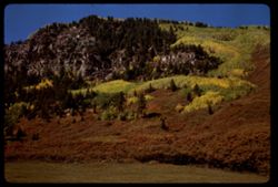
- Description:
- 100 f 13 tl
- Subject:
- Firs, Forests, Cliffs, Mountains, Trees, and Rock formations
- Series:
- 32-65
- Creator:
- Cushman, Charles W., 1896-1972
- Date Created:
- 1965-10-02
- Genre:
- Landscape photographs
- Frame Number:
- 29
- Street Address:
- United States Highway 550
- County:
- La Plata and San Juan
- Abstract:
- Cliffs & fall colors
- Call Number:
- P14947
- City:
- Silverton and Durango
- Country:
- United States
- State/Province:
- Colorado
- Alternate Identifier:
- 3265.29
- Persistent URL:
- http://purl.dlib.indiana.edu/iudl/archives/cushman/P14947
- Holding Location:
- Bloomington - University Archives
Wells Library E460
1320 E 10th St.
Bloomington, IN 47405
Contact at archives@indiana.edu, 812-855-1127
-
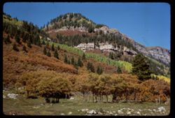
- Description:
- 100 f 13 tl
- Subject:
- Forests, Cliffs, Mountains, Trees, and Rock formations
- Series:
- 32-65
- Creator:
- Cushman, Charles W., 1896-1972
- Date Created:
- 1965-10-02
- Genre:
- Landscape photographs
- Frame Number:
- 27
- Street Address:
- United States Highway 550
- County:
- La Plata
- Abstract:
- Waterfall nearby
- Call Number:
- P14945
- City:
- Durango
- Country:
- United States
- State/Province:
- Colorado
- Alternate Identifier:
- 3265.27
- Persistent URL:
- http://purl.dlib.indiana.edu/iudl/archives/cushman/P14945
- Holding Location:
- Bloomington - University Archives
Wells Library E460
1320 E 10th St.
Bloomington, IN 47405
Contact at archives@indiana.edu, 812-855-1127
-
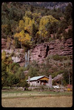
- Description:
- 100 f 13 tl
- Subject:
- Grasses, Houses, Waterfalls, Trees, Meadows, Mountains, Fences, Rock formations, Trucks, and Cliffs
- Series:
- 32-65
- Creator:
- Cushman, Charles W., 1896-1972
- Date Created:
- 1965-10-02
- Genre:
- Landscape photographs
- Frame Number:
- 26
- Street Address:
- United States Highway 550
- County:
- La Plata
- Abstract:
- Waterfall nearby
- Call Number:
- P14944
- City:
- Durango
- Country:
- United States
- State/Province:
- Colorado
- Alternate Identifier:
- 3265.26
- Persistent URL:
- http://purl.dlib.indiana.edu/iudl/archives/cushman/P14944
- Holding Location:
- Bloomington - University Archives
Wells Library E460
1320 E 10th St.
Bloomington, IN 47405
Contact at archives@indiana.edu, 812-855-1127
-
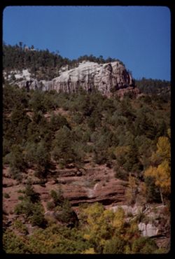
- Description:
- 100 f 13
- Subject:
- Grasses, Cliffs, Trees, Meadows, Mountains, Rock formations, and Houses
- Series:
- 32-65
- Creator:
- Cushman, Charles W., 1896-1972
- Date Created:
- 1965-10-02
- Genre:
- Landscape photographs
- Frame Number:
- 25
- Street Address:
- United States Highway 550
- County:
- La Plata
- Abstract:
- Horses below mtn side
- Call Number:
- P14943
- City:
- Durango
- Country:
- United States
- State/Province:
- Colorado
- Alternate Identifier:
- 3265.25
- Persistent URL:
- http://purl.dlib.indiana.edu/iudl/archives/cushman/P14943
- Holding Location:
- Bloomington - University Archives
Wells Library E460
1320 E 10th St.
Bloomington, IN 47405
Contact at archives@indiana.edu, 812-855-1127
-
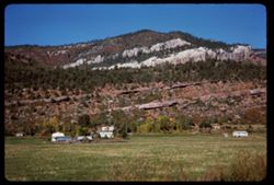
- Description:
- 100 f 11
- Subject:
- Electric lines, Houses, Mountains, Rock formations, Utility poles, and Croplands
- Series:
- 32-65
- Creator:
- Cushman, Charles W., 1896-1972
- Date Created:
- 1965-10-02
- Genre:
- Landscape photographs
- Frame Number:
- 21
- Street Address:
- United States Highway 550
- County:
- La Plata
- Abstract:
- few miles north of Durango
- Call Number:
- P14939
- City:
- Durango
- Country:
- United States
- State/Province:
- Colorado
- Alternate Identifier:
- 3265.21
- Persistent URL:
- http://purl.dlib.indiana.edu/iudl/archives/cushman/P14939
- Holding Location:
- Bloomington - University Archives
Wells Library E460
1320 E 10th St.
Bloomington, IN 47405
Contact at archives@indiana.edu, 812-855-1127
-
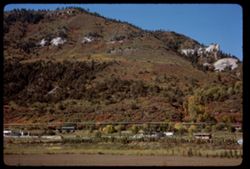
- Description:
- 50 f 8
- Subject:
- Canyons, Grasses, Cliffs, Trees, Red Canyon (Garfield County, Colo.), Tree limbs, Mountains, Rock formations, Clouds, and Hills
- Series:
- 9-53
- Creator:
- Cushman, Charles W., 1896-1972
- Date Created:
- 1953-10-13
- Genre:
- Landscape photographs
- Frame Number:
- 38
- County:
- Garfield
- Abstract:
- Red Canyon, south of Glenwood Spgs.
- Call Number:
- P06839
- City:
- Glenwood Springs
- Country:
- United States
- State/Province:
- Colorado
- Alternate Identifier:
- 953.38
- Persistent URL:
- http://purl.dlib.indiana.edu/iudl/archives/cushman/P06839
- Holding Location:
- Bloomington - University Archives
Wells Library E460
1320 E 10th St.
Bloomington, IN 47405
Contact at archives@indiana.edu, 812-855-1127
- « Previous
- Next »
- 1
- 2
- 3