
Search Constraints
You searched for:
Publisher
Главное управление геодезии и картографии при СНК СССР
Remove constraint Publisher: Главное управление геодезии и картографии при СНК СССР
Search Results
-
- Description:
- 1939
- Subject:
- Geographic Subject: Sady, Topical Subject: Maps, and Topical Subject: Soviet Union
- Publisher:
- Главное управление геодезии и картографии при СНК СССР
- Language:
- Russian
- Date Created:
- 1941
- Identifier:
- VAC9619-003505
- Genre:
- Military Maps and Topographic Maps
- Geographic Location:
- Coordinates: 56.167, 33.5, 56.333, 33.75
- Related URL:
- Download GeoTIFF: https://drive.google.com/file/d/1fm8wOb5L79SO_B23TV6HYKZHDDp9tWLv/view?usp=sharing and Catalog URL: http://iucat.iu.edu/catalog/5020131
- Abstract:
- Modern area represented: Сады (Sady), Tverskaya oblast, Russia
- Call Number:
- GM G7000 s50 .S68 sheet O-36-140-A
- Caption:
- Captured map
- City:
- Сады (Sady)
- Copyright Holder:
- No Copyright - United States
- Country:
- СССР (USSR)
- State/Province:
- Оленинский район (Oleninsky district), Калининская область (Kalinin oblast), and Молодотудский район (Molodotudsky district)
- Physical Description:
- Scale: 1:50,000
- Persistent URL:
- http://purl.dlib.indiana.edu/iudl/images/VAC9619/VAC9619-003505
- Provenance:
- DMA Topographic Center, Army Map Service Library, OMAHA, Library of Congress Geography & Map Division
-
- Description:
- 1939
- Subject:
- Geographic Subject: Olenino, Topical Subject: Maps, and Topical Subject: Soviet Union
- Publisher:
- Главное управление геодезии и картографии при СНК СССР
- Language:
- Russian
- Date Created:
- 1941
- Identifier:
- VAC9619-003503
- Genre:
- Military Maps and Topographic Maps
- Geographic Location:
- Coordinates: 56.167, 33.25, 56.333, 33.5
- Related URL:
- Download GeoTIFF: https://drive.google.com/file/d/14VfwnsGlRiwDLRroFLvT-YtlQlOdMpvz/view?usp=sharing and Catalog URL: http://iucat.iu.edu/catalog/5020131
- Abstract:
- Modern area represented: Оленино (Olenino), Tverskaya oblast, Russia
- Call Number:
- GM G7000 s50 .S68 sheet O-36-139-B
- City:
- Оленино (Olenino)
- Copyright Holder:
- No Copyright - United States
- Country:
- СССР (USSR)
- State/Province:
- Оленинский район (Oleninsky district) and Калининская область (Kalinin oblast)
- Physical Description:
- Scale: 1:50,000
- Persistent URL:
- http://purl.dlib.indiana.edu/iudl/images/VAC9619/VAC9619-003503
- Provenance:
- DMA Topographic Center, Army Map Service Library, OMAHA, Library of Congress Geography & Map Division
-
- Description:
- 1938
- Subject:
- Geographic Subject: Feryazkino, Topical Subject: Soviet Union, and Topical Subject: Maps
- Publisher:
- Главное управление геодезии и картографии при СНК СССР
- Language:
- Russian
- Date Created:
- 1941
- Identifier:
- VAC9619-003478
- Genre:
- Topographic Maps and Military Maps
- Geographic Location:
- Coordinates: 56.333, 35.75, 56.5, 36
- Related URL:
- Catalog URL: http://iucat.iu.edu/catalog/5020131 and Download GeoTIFF: https://drive.google.com/file/d/17W365JTid2GpJ9Vsdxn-jOk35JchUcHB/view?usp=sharing
- Abstract:
- Modern area represented: Ферязкино (Feryazkino), Tverskaya oblast, Russia
- Call Number:
- G7000 s50 .S68 sheet O-36-132-D
- City:
- Большое Ферязкино (Bol’shoye Feryazkino)
- Copyright Holder:
- No Copyright - United States
- Country:
- СССР (USSR)
- State/Province:
- Лотошинский район (Lotoshinsky district), Московская область (Moscow oblast), Калининская область (Kalinin oblast), and Тургиновский район (Turginovsky distr...
- Physical Description:
- Scale: 1:50,000
- Persistent URL:
- http://purl.dlib.indiana.edu/iudl/images/VAC9619/VAC9619-003478
- Provenance:
- DMA Topographic Center, Army Map Service Library, Library of Congress Geography & Map Division
-
- Description:
- 1938
- Subject:
- Geographic Subject: Rodnya, Topical Subject: Soviet Union, and Topical Subject: Maps
- Publisher:
- Главное управление геодезии и картографии при СНК СССР
- Language:
- Russian
- Date Created:
- 1941
- Identifier:
- VAC9619-003477
- Genre:
- Military Maps and Topographic Maps
- Geographic Location:
- Coordinates: 56.333, 34.75, 56.5, 35
- Related URL:
- Catalog URL: http://iucat.iu.edu/catalog/5020131 and Download GeoTIFF: https://drive.google.com/file/d/1REcEYzS-IqtvOX9vkRyhRwVimhCOaQL-/view?usp=sharing
- Abstract:
- Modern area represented: Родня (Rodnya), Tverskaya oblast, Russia
- Call Number:
- G7000 s50 .S68 sheet O-36-130-D
- City:
- Родня (Rodnya)
- Copyright Holder:
- No Copyright - United States
- Country:
- СССР (USSR)
- State/Province:
- Калининская область (Kalinin oblast), Старицкий район (Staritsky district), and Зубцовский район (Zubtsovsky district)
- Physical Description:
- Scale: 1:50,000
- Persistent URL:
- http://purl.dlib.indiana.edu/iudl/images/VAC9619/VAC9619-003477
- Provenance:
- DMA Topographic Center, Army Map Service Library, OMAHA, Library of Congress Geography & Map Division
-
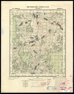
- Description:
- 1938
- Subject:
- Topical Subject: Soviet Union, Geographic Subject: Staritsa, and Topical Subject: Maps
- Publisher:
- Главное управление геодезии и картографии при СНК СССР
- Language:
- Russian
- Date Created:
- 1941
- Identifier:
- VAC9619-003476
- Genre:
- Topographic Maps and Military Maps
- Geographic Location:
- Coordinates: 56.5, 34.75, 56.667, 35
- Related URL:
- Download GeoTIFF: https://drive.google.com/file/d/1Ffo_UO7HIdQS1iN83jJIlQTlyLKvURbA/view?usp=sharing and Catalog URL: http://iucat.iu.edu/catalog/5020131
- Abstract:
- Modern area represented: Старица (Staritsa), Tverskaya oblast, Russia
- Call Number:
- G7000 s50 .S68 sheet O-36-130-B
- City:
- Старица (Staritsa)
- Copyright Holder:
- No Copyright - United States
- Country:
- СССР (USSR)
- State/Province:
- Высоковский район (Vysokovsky district), Калининская область (Kalinin oblast), and Старицкий район (Staritsky district)
- Physical Description:
- Scale: 1:50,000
- Persistent URL:
- http://purl.dlib.indiana.edu/iudl/images/VAC9619/VAC9619-003476
- Provenance:
- DMA Topographic Center, Army Map Service Library, OMAHA, Library of Congress Geography & Map Division
-
- Description:
- 1938
- Subject:
- Topical Subject: Maps, Geographic Subject: Plotnikovo, and Topical Subject: Soviet Union
- Publisher:
- Главное управление геодезии и картографии при СНК СССР
- Language:
- Russian
- Date Created:
- 1941
- Identifier:
- VAC9619-003474
- Genre:
- Military Maps and Topographic Maps
- Geographic Location:
- Coordinates: 56.333, 34.25, 56.5, 34.5
- Related URL:
- Catalog URL: http://iucat.iu.edu/catalog/5020131 and Download GeoTIFF: https://drive.google.com/file/d/1rtSI05x2OGdyNyY9GkpIk8olI5V_zoPE/view?usp=sharing
- Abstract:
- Modern area represented: Плотниково (Plotnikovo), Tverskaya oblast, Russia
- Call Number:
- G7000 s50 .S68 sheet O-36-129-D
- City:
- Плотниково (Plotnikovo)
- Copyright Holder:
- No Copyright - United States
- Country:
- СССР (USSR)
- State/Province:
- Ржевский район (Rzhevsky district), Калининская область (Kalinin oblast), and Луковниковский район (Lukovnikovsky district)
- Physical Description:
- Scale: 1:50,000
- Persistent URL:
- http://purl.dlib.indiana.edu/iudl/images/VAC9619/VAC9619-003474
- Provenance:
- DMA Topographic Center, Army Map Service Library, OMAHA, Library of Congress Geography & Map Division
-

- Description:
- 1938
- Subject:
- Geographic Subject: Ramen'ye, Topical Subject: Soviet Union, and Topical Subject: Maps
- Publisher:
- Главное управление геодезии и картографии при СНК СССР
- Language:
- Russian
- Date Created:
- 1941
- Identifier:
- VAC9619-003473
- Genre:
- Topographic Maps and Military Maps
- Geographic Location:
- Coordinates: 56.333, 34, 56.5, 34.25
- Related URL:
- Download GeoTIFF: https://drive.google.com/file/d/1qh-E-lgJptpwG6nUxUBiR_gBwnFCrbrW/view?usp=sharing and Catalog URL: http://iucat.iu.edu/catalog/5020131
- Abstract:
- Modern area represented: Раменье (Ramen'ye), Tverskaya oblast, Russia
- Call Number:
- G7000 s50 .S68 sheet O-36-129-C
- City:
- Раменье (Ramen'ye)
- Copyright Holder:
- No Copyright - United States
- Country:
- СССР (USSR)
- State/Province:
- Луковниковский район (Lukovnikovsky district), Калининская область (Kalinin oblast), Молодотудский район (Molodotudsky district), and Ржевский район (Rzhevsk...
- Physical Description:
- Scale: 1:50,000
- Persistent URL:
- http://purl.dlib.indiana.edu/iudl/images/VAC9619/VAC9619-003473
- Provenance:
- DMA Topographic Center, Army Map Service Library, OMAHA, Library of Congress Geography & Map Division
-
- Description:
- 1938
- Subject:
- Topical Subject: Maps, Geographic Subject: Pavlikovo, and Topical Subject: Soviet Union
- Publisher:
- Главное управление геодезии и картографии при СНК СССР
- Language:
- Russian
- Date Created:
- 1941
- Identifier:
- VAC9619-003472
- Genre:
- Topographic Maps and Military Maps
- Geographic Location:
- Coordinates: 56.5, 34.25, 56.667, 34.5
- Related URL:
- Download GeoTIFF: https://drive.google.com/file/d/1cM86uH12YBkYFhQNZjwCtN7j02FCIzUX/view?usp=sharing and Catalog URL: http://iucat.iu.edu/catalog/5020131
- Abstract:
- Modern area represented: Павликово (Pavlikovo), Tverskaya oblast, Russia
- Call Number:
- G7000 s50 .S68 sheet O-36-129-B
- City:
- Павликово (Pavlikovo)
- Copyright Holder:
- No Copyright - United States
- Country:
- СССР (USSR)
- State/Province:
- Луковниковский район (Lukovnikovsky district) and Калининская область (Kalinin oblast)
- Physical Description:
- Scale: 1:50,000
- Persistent URL:
- http://purl.dlib.indiana.edu/iudl/images/VAC9619/VAC9619-003472
- Provenance:
- M. I. Map Library, Library of Congress Geography & Map Division
-
- Description:
- 1939
- Subject:
- Geographic Subject: Okovtsy, Topical Subject: Maps, and Topical Subject: Soviet Union
- Publisher:
- Главное управление геодезии и картографии при СНК СССР
- Language:
- Russian
- Date Created:
- 1941
- Identifier:
- VAC9619-003471
- Genre:
- Topographic Maps and Military Maps
- Geographic Location:
- Coordinates: 56.5, 33.25, 56.667, 33.5
- Related URL:
- Download GeoTIFF: https://drive.google.com/file/d/1QrCmf9strde4Q_XXo1Oe5tCoJFq2VFP6/view?usp=sharing and Catalog URL: http://iucat.iu.edu/catalog/5020131
- Abstract:
- Modern area represented: Оковцы (Okovtsy), Tverskaya oblast, Russia
- Call Number:
- G7000 s50 .S68 sheet O-36-127-B
- City:
- Оковцы (Okovtsy)
- Copyright Holder:
- No Copyright - United States
- Country:
- СССР (USSR)
- State/Province:
- Кировский район (Kirov district), Молодотудский район (Molodotudsky district), and Калининская область (Kalinin oblast)
- Physical Description:
- Scale: 1:50,000
- Persistent URL:
- http://purl.dlib.indiana.edu/iudl/images/VAC9619/VAC9619-003471
- Provenance:
- DMA Topographic Center, Army Map Service Library, OMAHA, Library of Congress Geography & Map Division
-
- Description:
- 1939
- Subject:
- Topical Subject: Soviet Union, Geographic Subject: Vysokoye, and Topical Subject: Maps
- Publisher:
- Главное управление геодезии и картографии при СНК СССР
- Language:
- Russian
- Date Created:
- 1941
- Identifier:
- VAC9619-003470
- Genre:
- Topographic Maps and Military Maps
- Geographic Location:
- Coordinates: 56.333, 32.75, 56.5, 33
- Related URL:
- Download GeoTIFF: https://drive.google.com/file/d/12E5i-f2khtKqePPSxPnAOJT4oAAmYPRD/view?usp=sharing and Catalog URL: http://iucat.iu.edu/catalog/5020131
- Abstract:
- Modern area represented: Высокое (Vysokoye), Tverskaya oblast, Russia
- Call Number:
- G7000 s50 .S68 sheet O-36-126-D
- City:
- Высокое (Vysokoye)
- Copyright Holder:
- No Copyright - United States
- Country:
- СССР (USSR)
- State/Province:
- Нелидовский район (Nelidovsky district), Ленинский район (Leninsky district), Молодотудский район (Molodotudsky district), and Калининская область (Kalinin o...
- Physical Description:
- Scale: 1:50,000
- Persistent URL:
- http://purl.dlib.indiana.edu/iudl/images/VAC9619/VAC9619-003470
- Provenance:
- DMA Topographic Center, Army Map Service Library, OMAHA, Library of Congress Geography & Map Division
