
Search Constraints
« Previous |
1 - 10 of 72
|
Next »
Search Results
-
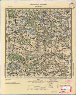
- Description:
- 1899
- Subject:
- Geographic Subject: Stotis Troškūnai, Topical Subject: Soviet Union, and Topical Subject: Maps
- Publisher:
- Генеральный штаб РККА
- Language:
- Russian
- Date Created:
- 1900
- Identifier:
- VAC9619-004016
- Genre:
- Military Maps and Topographic Maps
- Geographic Location:
- Coordinates: 55.333, 24.5, 55.667, 25
- Related URL:
- Catalog URL: https://iucat.iu.edu/catalog/5020129 and Download GeoTIFF: https://drive.google.com/file/d/18VVh-GXs6I1BI8dg6N2rrOxD0IKUrEQq/view?usp=sharing
- Abstract:
- Modern area represented: Stotis Troškūnai, Utena, Lithuania
- Call Number:
- G7000 s100 .S7 sheet N-35-14
- City:
- Трашкуны (Troskunai)
- Copyright Holder:
- No Copyright - United States
- Country:
- Литва (Lithuania)
- Physical Description:
- Scale: 1:100,000
- Persistent URL:
- http://purl.dlib.indiana.edu/iudl/images/VAC9619/VAC9619-004016
- Provenance:
- DMA Topographic Center, Army Map Service Library, University of Kansas Map Library
-
- Description:
- 1899
- Subject:
- Geographic Subject: Kupiškis, Topical Subject: Maps, and Topical Subject: Soviet Union
- Publisher:
- Генеральный штаб РККА
- Language:
- Russian
- Date Created:
- 1900
- Identifier:
- VAC9619-004005
- Genre:
- Military Maps and Topographic Maps
- Geographic Location:
- Coordinates: 55.667, 24.5, 56, 25
- Related URL:
- Catalog URL: https://iucat.iu.edu/catalog/5020129 and Download GeoTIFF: https://drive.google.com/file/d/1Vg5Smq-KoR5HMFKjMo5_iVWF15dfxhgq/view?usp=sharing
- Abstract:
- Modern area represented: Kupiškis, Panevėžys, Lithuania
- Call Number:
- G7000 s100 .S7 sheet N-35-2
- City:
- Купишкис (Kupiškis)
- Copyright Holder:
- No Copyright - United States
- Country:
- Литва (Lithuania)
- Physical Description:
- Scale: 1:100,000
- Persistent URL:
- http://purl.dlib.indiana.edu/iudl/images/VAC9619/VAC9619-004005
- Provenance:
- DMA Topographic Center, Army Map Service Library, Library of Congress Geography & Map Division
-
- Description:
- 1889
- Subject:
- Geographic Subject: Wieluń, Topical Subject: Soviet Union, and Topical Subject: Maps
- Publisher:
- Управление военных топографов РККА
- Language:
- Russian
- Date Created:
- 1900
- Identifier:
- VAC9619-002764
- Genre:
- Military Maps and Topographic Maps
- Geographic Location:
- Coordinates: 51, 18.5, 51.333, 19
- Related URL:
- Download GeoTIFF: https://drive.google.com/file/d/1XZ9grC_wlZBMQgyiAbRR4AzZaHUA6PNs/view?usp=sharing and Catalog URL: https://iucat.iu.edu/catalog/5020129
- Abstract:
- Modern area represented: Wieluń, Łódź province, Poland
- Call Number:
- G7000 s100 .S7 sheet M-34-26
- City:
- Велюнь (Wieluń)
- Copyright Holder:
- No Copyright - United States
- Country:
- Польша (Poland) and Германия (Germany)
- Physical Description:
- Scale: 1:100,000
- Persistent URL:
- http://purl.dlib.indiana.edu/iudl/images/VAC9619/VAC9619-002764
- Provenance:
- CIA Map Library, Geogr. Seminar Stuttgart
-
- Description:
- 1897
- Subject:
- Topical Subject: Maps, Topical Subject: Soviet Union, and Geographic Subject: Slobozia
- Publisher:
- Генеральный штаб РККА
- Language:
- Russian
- Date Created:
- 1900
- Identifier:
- VAC9619-001799
- Genre:
- Military Maps and Topographic Maps
- Geographic Location:
- Coordinates: 44.3333, 27, 44.6667, 27.5
- Related URL:
- Catalog URL: https://iucat.iu.edu/catalog/5020129 and Download GeoTIFF: https://drive.google.com/open?id=19PD0saZGwZmsVe87Ez_L0r_wN1P2Df2Z
- Abstract:
- Modern area represented: Slobozia, Ialomiţa county, Romania
- Call Number:
- G7000 s100 .S7 sheet L-35-127
- City:
- Слобозия (Slobozia)
- Copyright Holder:
- No Copyright - United States
- Country:
- Румыния (Romania)
- Physical Description:
- Scale: 1:100,000
- Persistent URL:
- http://purl.dlib.indiana.edu/iudl/images/VAC9619/VAC9619-001799
- Provenance:
- DMA Topographic Center, Army Map Service Library, OMAHA, Atlasblatt, Library of Congress Geography & Map Division
-
- Description:
- 1883
- Subject:
- Geographic Subject: Săruleştii Noi, Topical Subject: Maps, and Topical Subject: Soviet Union
- Publisher:
- Генеральный штаб РККА
- Language:
- Russian
- Date Created:
- 1900
- Identifier:
- VAC9619-001797
- Genre:
- Topographic Maps and Military Maps
- Geographic Location:
- Coordinates: 44.3333, 26.5, 44.6667, 27
- Related URL:
- Download GeoTIFF: https://drive.google.com/open?id=1EesHE3L4H_0ViZpG8C0yFlmV2wsNjrkU and Catalog URL: https://iucat.iu.edu/catalog/5020129
- Abstract:
- Modern area represented: Săruleştii Noi, Călăraşi county, Romania
- Call Number:
- G7000 s100 .S7 sheet L-35-126
- City:
- Сэрулешти (Săruleştii)
- Copyright Holder:
- No Copyright - United States
- Country:
- Румыния (Romania)
- Physical Description:
- Scale: 1:100,000
- Persistent URL:
- http://purl.dlib.indiana.edu/iudl/images/VAC9619/VAC9619-001797
- Provenance:
- DMA Topographic Center, Army Map Service Library, OMAHA, Atlasblatt, Library of Congress Geography & Map Division
-
- Description:
- 1899
- Subject:
- Topical Subject: Maps, Geographic Subject: Kirikküla, and Topical Subject: Soviet Union
- Publisher:
- Генеральный штаб РККА
- Language:
- Russian
- Date Created:
- 1900
- Identifier:
- VAC9619-001672
- Genre:
- Topographic Maps and Military Maps
- Geographic Location:
- Coordinates: 59.167, 23.75, 59.333, 24
- Related URL:
- Download GeoTIFF: https://drive.google.com/open?id=1FeHDvNEhbbvTSoTX1FXZ8m3u2efMEdDi and Catalog URL: http://iucat.iu.edu/catalog/5020131
- Abstract:
- Modern area represented: Kirikküla, Harjumaa county, Estonia
- Call Number:
- G7000 s50 .S68 sheet O-34-36-Б
- City:
- Кириккюла (Kirikküla)
- Copyright Holder:
- No Copyright - United States
- Country:
- Эстония (Estonia)
- Physical Description:
- Scale: 1:50,000
- Persistent URL:
- http://purl.dlib.indiana.edu/iudl/images/VAC9619/VAC9619-001672
- Provenance:
- DMA Topographic Center, Army Map Service Library, OMAHA, Library of Congress Geography & Map Division
-
- Description:
- 1890
- Subject:
- Topical Subject: Maps, Geographic Subject: Kersleti, and Topical Subject: Soviet Union
- Publisher:
- Управление военных топографов
- Language:
- Russian
- Date Created:
- 1900
- Identifier:
- VAC9619-001670
- Genre:
- Topographic Maps and Military Maps
- Geographic Location:
- Coordinates: 59, 23, 59.167, 23.25
- Related URL:
- Catalog URL: http://iucat.iu.edu/catalog/5020131 and Download GeoTIFF: https://drive.google.com/open?id=1hbDmzQAiMfBU_L1SZkfcXjJgwchyfKjV
- Abstract:
- Modern area represented: Kersleti, Lääne county, Estonia
- Call Number:
- G7000 s50 .S68 sheet O-34-35-B
- City:
- Керслет (Kersleti)
- Copyright Holder:
- No Copyright - United States
- Country:
- Эстония (Estonia)
- Physical Description:
- Scale: 1:50,000
- Persistent URL:
- http://purl.dlib.indiana.edu/iudl/images/VAC9619/VAC9619-001670
- Provenance:
- DMA Topographic Center, OMAHA, Geographic Names Branch, Army Map Service Library, Library of Congress Geography & Map Division
-
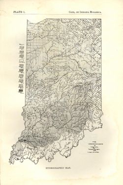
- Subject:
- Topical Subject: Watersheds and Geographic Subject: Indiana
- Creator:
- Call, Richard Ellsworth, 1856-1917
- Publisher:
- Indiana. Department of Geology and Natural Resources
- Date Created:
- 1900
- Identifier:
- VAC3073-M-01572
- Genre:
- Maps
- Geographic Location:
- Coordinates: W0880500 W0844700 N0414500 N0374600
- Related URL:
- Catalog URL: https://iucat.iu.edu/catalog/18418197
- Abstract:
- At foot of map: "Hydrographic map." At head of map: "Plate 1 -- Call, On Indiana mollusca." Detached from: A descriptive illustrated cata...
- Call Number:
- G4091.C315 1896 .C3
- Caption:
- Imprint: [Indianapolis] : [Department of Geology and Natural Resources], [1900] and Imprint: [Indianapolis] : [Wm. B. Burford], [1900]
- Physical Description:
- Dimensions: on sheet 22 x 15 cm and Scale: Approximately 1:1,267,200. 1 inch = 20 miles
- Alternate Identifier:
- Alternate ID: 390726IP and Title Control Number: a18418197
- Persistent URL:
- https://purl.dlib.indiana.edu/iudl/images/VAC3073/VAC3073-M-01572
- Provenance:
- 24th Annual Report (1899) / Indiana. Department of Geology and Natural Resources.
-
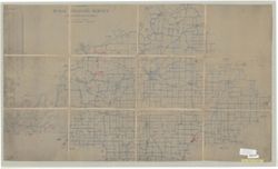
- Subject:
- Topical Subject: Postal service, Topical Subject: Rural free delivery, and Geographic Subject: Gibson County (Ind.)
- Creator:
- United States. Post Office Department
- Publisher:
- United States. Post Office Department
- Date Created:
- 1900
- Identifier:
- VAC3073-M-01240
- Genre:
- Maps
- Geographic Location:
- Coordinates: W0875917 W0871856 N0383200 N0380955
- Related URL:
- Catalog URL: https://iucat.iu.edu/catalog/6040366
- Abstract:
- Blue line. Map has been trimmed, date, part of title and other information is missing.
- Call Number:
- G4093.G5P8 1900 .U5
- Caption:
- Imprint: [Washington, D.C.] : U.S. Post Office Dept., 1900?
- Physical Description:
- Scale: 1:63,360 and Dimensions: 63 x 107 cm
- Persistent URL:
- https://purl.dlib.indiana.edu/iudl/images/VAC3073/VAC3073-M-01240
-
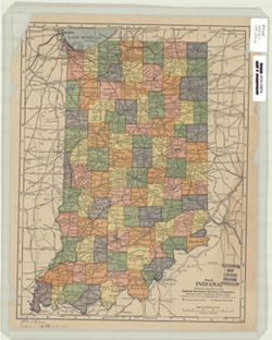
- Subject:
- Geographic Subject: Indiana
- Creator:
- Matthews-Northrup Company
- Publisher:
- Matthews-Northrup Company
- Date Created:
- 1900
- Identifier:
- VAC3073-M-00776
- Genre:
- Maps
- Geographic Location:
- Coordinates: W0880700 W0844500 N0414500 N0375200
- Related URL:
- Catalog URL: https://iucat.iu.edu/catalog/5165755
- Abstract:
- Shows counties, cities and towns, and railroads.
- Call Number:
- G4090 1900 .M48
- Caption:
- Imprint: Buffalo, N.Y. : Matthews-Northrup, [1900]
- Physical Description:
- Dimensions: 28 x 22 cm and Scale: 1:1,647,369
- Alternate Identifier:
- Title Control Number: a5165755
- Persistent URL:
- https://purl.dlib.indiana.edu/iudl/images/VAC3073/VAC3073-M-00776
