Indiana University
Indiana University
IU
Skip to Content
Digital Collections
Toggle navigation
Digital
Collections
Switch language
English
Switch language
Deutsch
English
Español
Français
Italiano
Português do Brasil
中文
Login
Home
About
Contact
Search Digital Collections
Go
×
Search Constraints
Start Over
You searched for:
Date Created
1938
Remove constraint Date Created: 1938
« Previous |
1
-
10
of
66
|
Next »
Sort by relevance ▼
relevance ▼
recently updated
title ▲
title ▼
date created ▲
date created ▼
pages ▲
pages ▼
collection size ▲
collection size ▼
Number of results to display per page
10 per page
10
per page
20
per page
50
per page
100
per page
View results as:
List
Gallery
Masonry
Search Results
1.
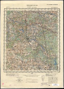
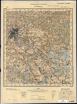
N-36-37 Богушевское
2.
N-36-25 Витебск
3.
N-36-1 Межа
4.
N-35-113 Ганцевиче
5.
N-35-112 Бытень
6.
N-35-97 Волковыск
7.
N-35-80 Минск
8.
N-35-69 Смолевичи
9.
N-35-56 Плещеницы
10.
N-35-45 Бегомль
« Previous
Next »
1
2
3
4
5
6
7
Toggle facets
Limit your search
Type
Image
66
Creator
Montgomery, Pauline
2
Bugbee, Harold
1
Joint Highway Research Project (Ind.)
1
Ulrich, H. P. (Herbert Paul), 1904-
1
Vrydagh, Allison L.
1
Contributor
Lewis, Willie New Bucy
1
Subject
Topical Subject: Maps
51
Topical Subject: Soviet Union
51
Geographic Subject: Indiana
6
Geographic Subject: Shet district
4
Topical Subject: Administrative and political divisions
3
Advertising --Motion pictures
2
Geographic Subject: Aktogay district
2
Lantern slides --Specimens
2
Motion picture film
2
Topical: Graves
2
more
Subjects
»
Language
Russian
51
English
1
Publisher
Генеральный штаб РККА
25
Генеральный штаб Красной Армии
17
Главное управление государственной съемки и картографии НКВД СССР
5
Главное управление геодезии и картографии при СНК СССР
4
[Bookwalter-Ball-Greathouse printing co.]
3
Bookwalter-Ball-Greathouse printing co.
1
Indiana. Department of Public Works
1
Joint Highway Research Project (Ind.)
1
United States. Bureau of Soils
1
[Dept.]
1
Date Created
1938
[remove]
66
Pages
0-99 pages
66
Collections
Russian Military Topographic Map Collection
51
Indiana Historic Maps
8
Ralston Lantern Slides
2
Hoagy Carmichael Photograph Collection
2
Pauline Montgomery Indiana Tombstone Photographs
2
Illustrators of the Golden West
1
State
deposited
66
Campus
IUB
63
IU Bloomington
1
IUPUI
1
Series
Groups
2
City
Jasper
1
Аннополь (Annopol)
1
Бегомль (Begoml)
1
Белокоровичи (Bilokorovychi)
1
Богушевское (Bogushëvskoe)
1
Бытень (Byten)
1
Вильсанди (Vilsandi)
1
Витебск (Vitebsk)
1
Волковыск (Volkovysk)
1
Ганцевиче (Hantsavichy)
1
Country
СССР (USSR)
45
Эстония (Estonia)
7
United States
2
Польша (Poland)
2
Венгрия (Hungary)
1
Карпатская Украина (Carpatho-Ukraine)
1
State/Province
Белорусская ССР (Byelorussian Soviet Socialist Republic)
17
Украинская ССР (Ukrainian Soviet Socialist Republic)
13
РСФСР (RSFSR)
10
Волынская область (Volyn oblast)
7
Карагандинская область (Karaganda oblast)
7
Ровенская область (Rivne oblast)
6
Витебская область (Vitebsk oblast)
5
Четский район (Shet district)
5
Минская область (Minsk oblast)
4
Пинская область (Pinsk oblast)
4
Publication Place
Clarendon Press, TX
1
Holding Location
B-WELLS
59
B-ARCHIVES
2
B-LILLY
2
I-EITELJORG
1
Provenance
DMA Topographic Center, Army Map Service Library, OMAHA, Library of Congress Geography & Map Division
13
DMA Topographic Center, Army Map Service Library, OMAHA
10
Indiana review, pictorial, political, historical (1938) / Indiana. Department of Public Works.
5
CIA Map Library
4
Army Map Service Library, OMAHA, Library of Congress Geography & Map Division
3
DMA Topographic Center, Army Map Service Library, Library of Congress Geography & Map Division
3
DMA Topographic Center, Library of Congress G & M Division, Army Map Service Library, Auswärtiges Amt. Geographischer Dienst, OMAHA
3
DMA Topographic Center, Library of Congress G & M Division, Army Map Service Library, OMAHA
2
Army Map Service Library, Library of Congress G & M Division
1
Army Map Service Library, Library of Congress G & M Division, Geographic Names Branch
1