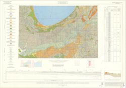
Prepared for the Monroe County Plan Commission by Kenneth L. Schellie & Associates. "Land use survey taken June 1961". Includes locator and ind...
Call Number:
G4093.M7A43 1987 .N38 sheet 1
Caption:
Imprint: [Bloomington, Indiana] : Monroe County Plan Commission, 1961
Physical Description:
Dimensions: 111 x 88 cm, on sheet 144 x 105 cm and Scale: Approximately 1:36,864
Prepared for the Monroe County Plan Commission by Kenneth L. Schellie & Associates. "Land use survey taken June, 1961". Includes locator and in...
Call Number:
G4093.M7G4 1961 .S34 sheet 7
Caption:
Imprint: [Bloomington, Indiana] : Monroe County Plan Commission, 1961
Physical Description:
Dimensions: 82 x 81 cm, on sheet 144 x 105 cm and Scale: Approximately 1:12,152
Prepared for the Monroe County Plan Commission by Kenneth L. Schellie & Associates. "Land use survey taken June, 1961". Includes locator and in...
Call Number:
G4094.M7G4 1961 .S34 sheet 8
Caption:
Imprint: [Bloomington, Indiana] : Monroe County Plan Commission, 1961
Physical Description:
Scale: Approximately 1:12,152 and Dimensions: 81 x 83 cm, on sheet 144 x 105 cm
Prepared for the Monroe County Plan Commission by Kenneth L. Schellie & Associates. "Land use survey taken June 1961". Includes locator and ind...
Call Number:
G4093.M7G4 1961 .S34 sheet 2
Caption:
Imprint: [Bloomington, Indiana] : Monroe County Plan Commission, 1961
Physical Description:
Dimensions: 104 x 82 cm, on sheet 144 x 105 cm and Scale: Approximately 1:12,152
Prepared for the Monroe County Plan Commission by Kenneth L. Schellie & Associates. "Land use survey taken June 1961". Includes locator and ind...
Call Number:
G4093.M7G4 1961 .S34 sheet 12
Caption:
Imprint: [Bloomington, Indiana] : Monroe County Plan Commission, 1961
Physical Description:
Dimensions: 84 x 69 cm, on sheet 144 x 105 cm and Scale: Approximately 1:12,152
Prepared for the Monroe County Plan Commission by Kenneth L. Schellie & Associates. "Land use survey taken June 1961". Includes locator and ind...
Call Number:
G4093.M7G4 1961 .S34 sheet 11
Caption:
Imprint: [Bloomington, Indiana] : Monroe County Plan Commission, 1961
Physical Description:
Dimensions: 83 x 69 cm, on sheet 144 x 105 cm and Scale: Approximately 1:12,152
Prepared for the Monroe County Plan Commission by Kenneth L. Schellie & Associates. "Land use survey taken June 1961". Includes locator and ind...
Call Number:
G4093.M7G4 1961 .S34 sheet 4
Caption:
Imprint: [Bloomington, Indiana] : Monroe County Plan Commission, 1961
Physical Description:
Scale: Approximately 1:12,152 and Dimensions: 96 x 81 cm, on sheet 144 x 105 cm
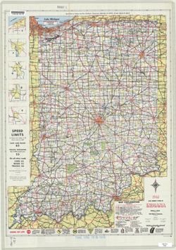
Gray on white with "controlled access sections on primary roads where project agreement requires B.P.R. approval before any driveway permits can be gran...
Call Number:
G1403 .S7 1961
Caption:
Imprint: [Indianapolis] : State Highway Commission, [1961]
Physical Description:
Scale: Approximately 1:633,600 and Dimensions: 94 x 59 cm
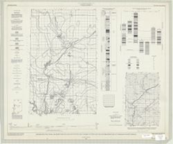
Geographic Subject: Warren County (Ind.), Topical Subject: Coal mines and mining, Geographic Subject: Vermillion County (Ind.), and Geographic Subject: Fount...
Creator:
Hutchison, Harold C. (Harold Christy), 1925-
Publisher:
Indiana. Geological Survey
Date Created:
1961
Identifier:
VAC3073-M-00418
Genre:
Mine maps
Geographic Location:
Coordinates: W0873200 W0870533 N0402800 N0395645
Related URL:
Catalog URL: https://iucat.iu.edu/catalog/4898738
Abstract:
"Preliminary coal map no. 9"--Margin. Includes 1 ancillary map, 1 diagram showing township enumeration, 1 index map, 1 stratigraphic column, and 1 ...
Call Number:
G4093.F6H9 1961 .H88
Caption:
Imprint: Bloomington : Indiana Dept. of Conservation, Geological Survey, 1961.

![Monroe County, Indiana, existing use of land. Sheet 1 [Index map]](https://iiif.uits.iu.edu/iiif/2/m039m802g%2Ffiles%2F61ffcc89-f677-469c-9d08-e45a2fe17a72/full/250,/0/default.jpg)

![[Monroe County, Indiana, existing use of land.] Sheet 7. Indian Creek Township, Monroe County, Indiana, existing use of land](https://iiif.uits.iu.edu/iiif/2/k356b6509%2Ffiles%2Fb57dc2b2-49f8-4d22-945b-30cd2e61374f/full/250,/0/default.jpg)
![[Monroe County, Indiana, existing use of land.] Sheet 8. Clear Creek Township, Monroe County, Indiana, existing use of land](https://iiif.uits.iu.edu/iiif/2/3r075z830%2Ffiles%2F6624980a-c7ac-4eaf-bb62-798890fa2939/full/250,/0/default.jpg)
![[Monroe County, Indiana, existing use of land.] Sheet 2. Bloomington Township, Monroe County, Indiana, existing use of land](https://iiif.uits.iu.edu/iiif/2/cr56p471g%2Ffiles%2F05a45fb1-c37c-4705-9f7e-ec975807ea66/full/250,/0/default.jpg)
![[Monroe County, Indiana, existing use of land.] Sheet 12. Benton Township, Monroe County, Indiana, existing use of land](https://iiif.uits.iu.edu/iiif/2/pk02dg046%2Ffiles%2F21334cc8-1ad7-4a01-9cda-637ff6bf681d/full/250,/0/default.jpg)
![[Monroe County, Indiana, existing use of land.] Sheet 11. Benton Township, Monroe County, Indiana, existing use of land](https://iiif.uits.iu.edu/iiif/2/t722jd621%2Ffiles%2Fcfcb861c-4fcf-48b8-852c-58224d757b56/full/250,/0/default.jpg)
![[Monroe County, Indiana, existing use of land.] Sheet 4. Bean Blossom Township, Monroe County, Indiana, existing use of land](https://iiif.uits.iu.edu/iiif/2/f4753k30w%2Ffiles%2F29aed0b2-c53e-484c-98d7-132971e3ecce/full/250,/0/default.jpg)