
Search Constraints
You searched for:
State/Province
Калмыцкая АССР (Kalmyk Autonomous Soviet Socialist Republic)
Remove constraint State/Province: Калмыцкая АССР (Kalmyk Autonomous Soviet Socialist Republic)
State/Province
Орджоникидзевский край (Ordzhonikidze kray)
Remove constraint State/Province: Орджоникидзевский край (Ordzhonikidze kray)
State/Province
РСФСР (RSFSR)
Remove constraint State/Province: РСФСР (RSFSR)
« Previous |
1 - 10 of 15
|
Next »
Search Results
-

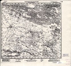
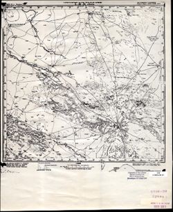
- Description:
- 1938
- Subject:
- Topical Subject: Maps, Geographic Subject: Krasnogvardeyskoe, and Topical Subject: Soviet Union
- Publisher:
- Главное управление геодезии и картографии при СНК СССР
- Language:
- Russian
- Date Created:
- 1941
- Identifier:
- VAC9619-002343
- Genre:
- Topographic Maps and Military Maps
- Geographic Location:
- Coordinates: 45.667, 41.5, 46, 42
- Related URL:
- Download GeoTIFF: https://drive.google.com/file/d/1AVr-cwCpH2TyChEw-jxKdVkFJnNQ8ff2/view?usp=sharing and Catalog URL: https://iucat.iu.edu/catalog/5020129
- Abstract:
- Modern area represented: Krasnogvardeyskoe, Stavropol kray, Russia
- Call Number:
- G7000 s100 .S7 sheet L-37-84
- Caption:
- Для служебного пользования
- City:
- Молотовское (Molotovskoe)
- Copyright Holder:
- No Copyright - United States
- Country:
- СССР (USSR)
- State/Province:
- Орджоникидзевский край (Ordzhonikidze kray), Калмыцкая АССР (Kalmyk Autonomous Soviet Socialist Republic), Ростовская область (Rostov oblast), and РСФСР (RSFSR)
- Physical Description:
- Scale: 1:100,000
- Persistent URL:
- http://purl.dlib.indiana.edu/iudl/images/VAC9619/VAC9619-002343
- Provenance:
- DMA Topographic Center, Army Map Service Library, OMAHA
-
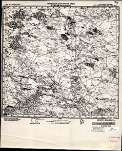
- Description:
- 1931
- Subject:
- Topical Subject: Maps, Topical Subject: Soviet Union, and Geographic Subject: Andratinskiy
- Publisher:
- Генеральный штаб Красной Армии
- Language:
- Russian
- Date Created:
- 1942
- Identifier:
- VAC9619-002205
- Genre:
- Military Maps and Topographic Maps
- Geographic Location:
- Coordinates: 44.6667, 46, 45, 46.5
- Related URL:
- Catalog URL: https://iucat.iu.edu/catalog/5020129 and Download GeoTIFF: https://drive.google.com/file/d/1m1Wa4SOQdr1d6mxZptjoRhfP8ZWy1e9_/view?usp=sharing
- Abstract:
- Modern area represented: Andratinskiy, Kalmykiya Republic, Russia
- Call Number:
- G7000 s100 .S7 sheet L-38-117
- Caption:
- Для служебного пользования
- City:
- Андра-Ата (Andra-Ata)
- Copyright Holder:
- No Copyright - United States
- Country:
- СССР (USSR)
- State/Province:
- РСФСР (RSFSR), Орджоникидзевский край (Ordzhonikidze kray), and Калмыцкая АССР (Kalmyk Autonomous Soviet Socialist Republic)
- Physical Description:
- Scale: 1:100,000
- Persistent URL:
- http://purl.dlib.indiana.edu/iudl/images/VAC9619/VAC9619-002205
- Provenance:
- DMA Topographic Center, Army Map Service Library
-
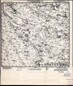
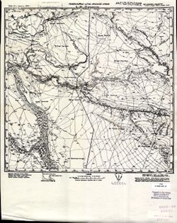
- Description:
- 1941
- Subject:
- Topical Subject: Soviet Union, Geographic Subject: Bakres, and Topical Subject: Maps
- Publisher:
- Генеральный штаб Красной Армии
- Language:
- Russian
- Date Created:
- 1942
- Identifier:
- VAC9619-002204
- Genre:
- Topographic Maps and Military Maps
- Geographic Location:
- Coordinates: 44.6667, 45.5, 45, 46
- Related URL:
- Catalog URL: https://iucat.iu.edu/catalog/5020129 and Download GeoTIFF: https://drive.google.com/file/d/1AJLkcZgpYOsDHCtkJc31gv9140nbE6P8/view?usp=sharing
- Abstract:
- Modern area represented: Bakres, Stavropol kray, Russia
- Call Number:
- G7000 s100 .S7 sheet L-38-116
- Caption:
- Для служебного пользования
- City:
- Бакрес (Bakres)
- Copyright Holder:
- No Copyright - United States
- Country:
- СССР (USSR)
- State/Province:
- Калмыцкая АССР (Kalmyk Autonomous Soviet Socialist Republic), Орджоникидзевский край (Ordzhonikidze kray), and РСФСР (RSFSR)
- Physical Description:
- Scale: 1:100,000
- Persistent URL:
- http://purl.dlib.indiana.edu/iudl/images/VAC9619/VAC9619-002204
- Provenance:
- CIA Map Library
-
- Description:
- 1927
- Subject:
- Topical Subject: Soviet Union, Topical Subject: Maps, and Geographic Subject: Prikumskiy
- Publisher:
- Генеральный штаб Красной Армии
- Language:
- Russian
- Date Created:
- 1942
- Identifier:
- VAC9619-002175
- Genre:
- Topographic Maps and Military Maps
- Geographic Location:
- Coordinates: 45, 45.5, 45.3333, 46
- Related URL:
- Download GeoTIFF: https://drive.google.com/open?id=1oNieSvSiim9Nn6Cs0QFvFcMbSpYbCy7x and Catalog URL: https://iucat.iu.edu/catalog/5020129
- Abstract:
- Modern area represented: Prikumskiy, Kalmykiya Republic, Russia
- Call Number:
- G7000 s100 .S7 sheet L-38-104
- Caption:
- Для служебного пользования
- City:
- Свх. №109 Улан Туг (Ulan Tug)
- Copyright Holder:
- No Copyright - United States
- Country:
- СССР (USSR)
- State/Province:
- Калмыцкая АССР (Kalmyk Autonomous Soviet Socialist Republic), РСФСР (RSFSR), Кизлярский округ (Kizlyar district), and Орджоникидзевский край (Ordzhonikidze k...
- Physical Description:
- Scale: 1:100,000
- Persistent URL:
- http://purl.dlib.indiana.edu/iudl/images/VAC9619/VAC9619-002175
- Provenance:
- CIA Map Library
-
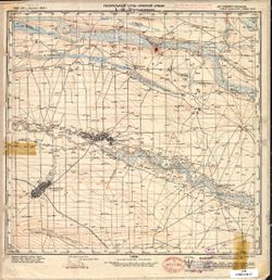
- Description:
- 1927
- Subject:
- Topical Subject: Soviet Union, Geographic Subject: Perekrestnyy, and Topical Subject: Maps
- Publisher:
- Генеральный штаб Красной Армии
- Language:
- Russian
- Date Created:
- 1942
- Identifier:
- VAC9619-002174
- Genre:
- Topographic Maps and Military Maps
- Geographic Location:
- Coordinates: 45, 45, 45.3333, 45.5
- Related URL:
- Download GeoTIFF: https://drive.google.com/open?id=1PufmFUSTdGToOsH9jP81y_oUAmZLg9iD and Catalog URL: https://iucat.iu.edu/catalog/5020129
- Abstract:
- Modern area represented: Perekrestnyy, Kalmykiya Republic, Russia
- Call Number:
- G7000 s100 .S7 sheet L-38-103
- Caption:
- Для служебного пользования
- City:
- Перекрестный (Perekrestnyy)
- Copyright Holder:
- No Copyright - United States
- Country:
- СССР (USSR)
- State/Province:
- Орджоникидзевский край (Ordzhonikidze kray), Калмыцкая АССР (Kalmyk Autonomous Soviet Socialist Republic), Кизлярский округ (Kizlyar district), and РСФСР (RS...
- Physical Description:
- Scale: 1:100,000
- Persistent URL:
- http://purl.dlib.indiana.edu/iudl/images/VAC9619/VAC9619-002174
- Provenance:
- CIA Map Library
-
- Description:
- 1932
- Subject:
- Topical Subject: Soviet Union, Geographic Subject: Sostinskiy, and Topical Subject: Maps
- Publisher:
- Генеральный штаб Красной Армии
- Language:
- Russian
- Date Created:
- 1942
- Identifier:
- VAC9619-002165
- Genre:
- Topographic Maps and Military Maps
- Geographic Location:
- Coordinates: 45.3333, 45, 45.6667, 45.5
- Related URL:
- Download GeoTIFF: https://drive.google.com/open?id=1mPzTxGKH5jVyadj_6X9zxs5fzkbRDVmU and Catalog URL: https://iucat.iu.edu/catalog/5020129
- Abstract:
- Modern area represented: Sostinskiy, Kalmykiya Republic, Russia
- Call Number:
- G7000 s100 .S7 sheet L-38-91
- Caption:
- Для служебного пользования
- City:
- Ачинеры (Achinery)
- Copyright Holder:
- No Copyright - United States
- Country:
- СССР (USSR)
- State/Province:
- РСФСР (RSFSR), Калмыцкая АССР (Kalmyk Autonomous Soviet Socialist Republic), and Орджоникидзевский край (Ordzhonikidze kray)
- Physical Description:
- Scale: 1:100,000
- Persistent URL:
- http://purl.dlib.indiana.edu/iudl/images/VAC9619/VAC9619-002165
- Provenance:
- CIA Map Library
-
- Description:
- 1927
- Subject:
- Topical Subject: Maps and Topical Subject: Soviet Union
- Publisher:
- Генеральный штаб Красной Армии
- Language:
- Russian
- Date Created:
- 1942
- Identifier:
- VAC9619-002164
- Genre:
- Topographic Maps and Military Maps
- Geographic Location:
- Coordinates: 45.3333, 44.5, 45.6667, 45
- Related URL:
- Catalog URL: https://iucat.iu.edu/catalog/5020129 and Download GeoTIFF: https://drive.google.com/open?id=10x7gtyFMb3-LHQ-wgNBMLfYtkf3w11nn
- Call Number:
- G7000 s100 .S7 sheet L-38-90
- Caption:
- Для служебного пользования
- City:
- Колхоз Красный Маныч (Krasniy Manich Collective Farm)
- Copyright Holder:
- No Copyright - United States
- Country:
- СССР (USSR)
- State/Province:
- Орджоникидзевский край (Ordzhonikidze kray), Калмыцкая АССР (Kalmyk Autonomous Soviet Socialist Republic), and РСФСР (RSFSR)
- Physical Description:
- Scale: 1:100,000
- Persistent URL:
- http://purl.dlib.indiana.edu/iudl/images/VAC9619/VAC9619-002164
- Provenance:
- DMA Topographic Center, Army Map Service Library
-
- Description:
- 1929
- Subject:
- Geographic Subject: Dzhedzhikiny, Topical Subject: Maps, and Topical Subject: Soviet Union
- Publisher:
- Генеральный штаб Красной Армии
- Language:
- Russian
- Date Created:
- 1942
- Identifier:
- VAC9619-002078
- Genre:
- Military Maps and Topographic Maps
- Geographic Location:
- Coordinates: 45.6667, 44, 46, 44.5
- Related URL:
- Catalog URL: https://iucat.iu.edu/catalog/5020129 and Download GeoTIFF: https://drive.google.com/open?id=1-e6xmnH5IggWCHttGOMdAG_EyIALG0L2
- Abstract:
- Modern area represented: Dzhedzhikiny, Kalmykiya Republic, Russia
- Call Number:
- G7000 s100 .S7 sheet L-38-77
- Caption:
- Для служебного пользования
- City:
- Джеджекины (Dzhedzhikiny)
- Copyright Holder:
- No Copyright - United States
- Country:
- СССР (USSR)
- State/Province:
- РСФСР (RSFSR), Орджоникидзевский край (Ordzhonikidze kray), and Калмыцкая АССР (Kalmyk Autonomous Soviet Socialist Republic)
- Physical Description:
- Scale: 1:100,000
- Persistent URL:
- http://purl.dlib.indiana.edu/iudl/images/VAC9619/VAC9619-002078
- Provenance:
- CIA Map Library, Heeresplankammer Auslandskartenarchiv, Atlasblatt
-
- Description:
- 1927
- Subject:
- Topical Subject: Soviet Union, Topical Subject: Maps, and Geographic Subject: Apanasenkovskoye
- Publisher:
- Генеральный штаб Красной Армии
- Language:
- Russian
- Date Created:
- 1942
- Identifier:
- VAC9619-002077
- Genre:
- Military Maps and Topographic Maps
- Geographic Location:
- Coordinates: 45.6667, 43.5, 46, 44
- Related URL:
- Catalog URL: https://iucat.iu.edu/catalog/5020129 and Download GeoTIFF: https://drive.google.com/open?id=18E95hi05O6YGGh4W2gX4I7fcvEoNrMUR
- Abstract:
- Modern area represented: Apanasenkovskoye, Stavropol kray, Russia
- Call Number:
- G7000 s100 .S7 sheet L-38-76
- Caption:
- Для служебного пользования
- City:
- Апанасенковское (Apanasenkovskoye)
- Copyright Holder:
- No Copyright - United States
- Country:
- СССР (USSR)
- State/Province:
- Орджоникидзевский край (Ordzhonikidze kray), РСФСР (RSFSR), and Калмыцкая АССР (Kalmyk Autonomous Soviet Socialist Republic)
- Physical Description:
- Scale: 1:100,000
- Persistent URL:
- http://purl.dlib.indiana.edu/iudl/images/VAC9619/VAC9619-002077
- Provenance:
- DMA Topographic Center, Library of Congress Geography & Map Division, Atlasblatt
-
- Description:
- 1930
- Subject:
- Geographic Subject: Ipatovo, Topical Subject: Soviet Union, and Topical Subject: Maps
- Publisher:
- Главное управление геодезии и картографии при СНК СССР
- Language:
- Russian
- Date Created:
- 1941
- Identifier:
- VAC9619-002075
- Genre:
- Topographic Maps and Military Maps
- Geographic Location:
- Coordinates: 45.6667, 42.5, 46, 43
- Related URL:
- Download GeoTIFF: https://drive.google.com/open?id=1uYm7E4Ln86KvT-Fc9-5nOxrUsVGDIYGe and Catalog URL: https://iucat.iu.edu/catalog/5020129
- Abstract:
- Modern area represented: Ipatovo, Stavropol kray, Russia
- Call Number:
- G7000 s100 .S7 sheet L-38-74
- Caption:
- Для служебного пользования
- City:
- Ипатово (Ipatovo)
- Copyright Holder:
- No Copyright - United States
- Country:
- СССР (USSR)
- State/Province:
- Калмыцкая АССР (Kalmyk Autonomous Soviet Socialist Republic), РСФСР (RSFSR), and Орджоникидзевский край (Ordzhonikidze kray)
- Physical Description:
- Scale: 1:100,000
- Persistent URL:
- http://purl.dlib.indiana.edu/iudl/images/VAC9619/VAC9619-002075
- Provenance:
- CIA Map Library
