
Search Constraints
You searched for:
Country
СССР (USSR)
Remove constraint Country: СССР (USSR)
Date Created
1941
Remove constraint Date Created: 1941
State/Province
Ленинградская область (Leningrad oblast)
Remove constraint State/Province: Ленинградская область (Leningrad oblast)
State/Province
Чудовский район (Chudovsky district)
Remove constraint State/Province: Чудовский район (Chudovsky district)
« Previous |
1 - 10 of 13
|
Next »
Search Results
-
- Description:
- 1937
- Subject:
- Geographic Subject: Gryady, Topical Subject: Soviet Union, and Topical Subject: Maps
- Publisher:
- Главное управление государственной съемки и картографии НКВД СССР
- Language:
- Russian
- Date Created:
- 1941
- Identifier:
- VAC9619-003347
- Genre:
- Military Maps and Topographic Maps
- Geographic Location:
- Coordinates: 58.8333, 31.75, 59.0, 32.0
- Related URL:
- DataCORE Dataset Download: https://datacore.iu.edu/concern/data_sets/t148fj174
- Abstract:
- Modern area represented: Гряды (Gryady), Novgorodskaya oblast, Russia
- Call Number:
- G7000 s50 .S68 sheet O-36-40-B
- Caption:
- Captured map and Для служебного пользования
- City:
- Гряды (Gryady)
- Copyright Holder:
- No Copyright - United States
- Country:
- СССР (USSR)
- State/Province:
- Чудовский район (Chudovsky district), Ленинградская область (Leningrad oblast), Маловишерский район (Malovishersky district), and РСФСР (RSFSR)
- Physical Description:
- Scale: 1:50,000
- Persistent URL:
- http://purl.dlib.indiana.edu/iudl/images/VAC9619/VAC9619-003347
- Provenance:
- Army Map Service Library, OMAHA, Library of Congress Geography & Map Division
-
- Description:
- 1937
- Subject:
- Topical Subject: Soviet Union, Topical Subject: Maps, and Geographic Subject: Myasnoy Bor
- Publisher:
- Главное управление государственной съемки и картографии НКВД СССР
- Language:
- Russian
- Date Created:
- 1941
- Identifier:
- VAC9619-003345
- Genre:
- Military Maps and Topographic Maps
- Geographic Location:
- Coordinates: 58.667, 31.25, 58.833, 31.5
- Related URL:
- DataCORE Dataset Download: https://datacore.iu.edu/concern/data_sets/0v8381465
- Abstract:
- Modern area represented: Мясной Бор (Myasnoy Bor), Novgorodskaya oblast, Russia
- Call Number:
- G7000 s50 .S68 sheet O-36-39-D
- Caption:
- Для служебного пользования
- City:
- Мясной Бор (Myasnoy Bor)
- Copyright Holder:
- No Copyright - United States
- Country:
- СССР (USSR)
- State/Province:
- Ленинградская область (Leningrad oblast), Чудовский район (Chudovsky district), РСФСР (RSFSR), and Новгородский район (Novgorod district)
- Physical Description:
- Scale: 1:50,000
- Persistent URL:
- http://purl.dlib.indiana.edu/iudl/images/VAC9619/VAC9619-003345
- Provenance:
- Army Map Service Library, OMAHA, Library of Congress Geography & Map Division
-
- Description:
- 1937
- Subject:
- Topical Subject: Maps, Topical Subject: Soviet Union, and Geographic Subject: Lyubino Pole
- Publisher:
- Главное управление государственной съемки и картографии НКВД СССР
- Language:
- Russian
- Date Created:
- 1941
- Identifier:
- VAC9619-003343
- Genre:
- Topographic Maps and Military Maps
- Geographic Location:
- Coordinates: 58.833, 31.25, 59, 31.5
- Related URL:
- DataCORE Dataset Download: https://datacore.iu.edu/concern/data_sets/qj72p7894
- Abstract:
- Modern area represented: Любино Поле (Lyubino Pole), Novgorodskaya oblast, Russia
- Call Number:
- G7000 s50 .S68 sheet O-36-39-B
- Caption:
- Секретно
- City:
- Любино Поле (Lyubino Pole)
- Copyright Holder:
- No Copyright - United States
- Country:
- СССР (USSR)
- State/Province:
- РСФСР (RSFSR), Ленинградская область (Leningrad oblast), Новгородский район (Novgorod district), Чудовский район (Chudovsky district), and Тосненский район (...
- Physical Description:
- Scale: 1:50,000
- Persistent URL:
- http://purl.dlib.indiana.edu/iudl/images/VAC9619/VAC9619-003343
- Provenance:
- Army Map Service Library, OMAHA, Library of Congress Geography & Map Division
-
- Description:
- 1937
- Subject:
- Topical Subject: Maps, Topical Subject: Soviet Union, and Geographic Subject: Finev Lug
- Publisher:
- Главное управление государственной съемки и картографии НКВД СССР
- Language:
- Russian
- Date Created:
- 1941
- Identifier:
- VAC9619-003342
- Genre:
- Topographic Maps and Military Maps
- Geographic Location:
- Coordinates: 58.833, 31, 59, 31.25
- Related URL:
- DataCORE Dataset Download: https://datacore.iu.edu/concern/data_sets/mw22v6216
- Abstract:
- Modern area represented: Финев Луг (Finev Lug), Novgorodskaya oblast, Russia
- Call Number:
- G7000 s50 .S68 sheet O-36-39-A
- Caption:
- Секретно and Captured map
- City:
- Финев Луг (Finev Lug)
- Copyright Holder:
- No Copyright - United States
- Country:
- СССР (USSR)
- State/Province:
- РСФСР (RSFSR), Новгородский район (Novgorod district), Чудовский район (Chudovsky district), Тосненский район (Tosnensky district), and Ленинградская область...
- Physical Description:
- Scale: 1:50,000
- Persistent URL:
- http://purl.dlib.indiana.edu/iudl/images/VAC9619/VAC9619-003342
- Provenance:
- Army Map Service Library, OMAHA, Library of Congress Geography & Map Division
-
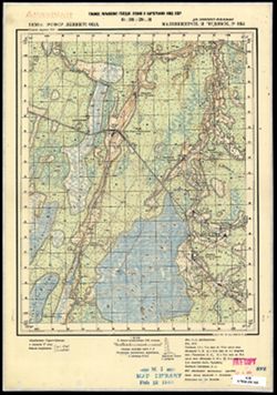
- Description:
- 1936
- Subject:
- Topical Subject: Soviet Union, Geographic Subject: Glad', and Topical Subject: Maps
- Publisher:
- Главное управление государственной съемки и картографии НКВД СССР
- Language:
- Russian
- Date Created:
- 1941
- Identifier:
- VAC9619-003327
- Genre:
- Topographic Maps and Military Maps
- Geographic Location:
- Coordinates: 59, 32, 59.167, 32.25
- Related URL:
- DataCORE Dataset Download: https://datacore.iu.edu/concern/data_sets/ng451j39d
- Abstract:
- Modern area represented: Гладь (Glad'), Novgorodskaya oblast, Russia
- Call Number:
- G7000 s50 .S68 sheet O-36-29-C
- Caption:
- Для служебного пользования and Captured map
- City:
- Гладь (Glad')
- Copyright Holder:
- No Copyright - United States
- Country:
- СССР (USSR)
- State/Province:
- РСФСР (RSFSR), Ленинградская область (Leningrad oblast), Маловишерский район (Malovishersky district), and Чудовский район (Chudovsky district)
- Physical Description:
- Scale: 1:50,000
- Persistent URL:
- http://purl.dlib.indiana.edu/iudl/images/VAC9619/VAC9619-003327
- Provenance:
- Army Map Service Library, OMAHA, Library of Congress Geography & Map Division
-
- Description:
- 1936
- Subject:
- Topical Subject: Maps, Topical Subject: Soviet Union, and Geographic Subject: Glad'
- Publisher:
- Главное управление государственной съемки и картографии НКВД СССР
- Language:
- Russian
- Date Created:
- 1941
- Identifier:
- VAC9619-003326
- Genre:
- Military Maps and Topographic Maps
- Geographic Location:
- Coordinates: 59, 32, 59.167, 32.25
- Related URL:
- DataCORE Dataset Download: https://datacore.iu.edu/concern/data_sets/gq67js087
- Abstract:
- Modern area represented: Гладь (Glad'), Novgorodskaya oblast, Russia
- Call Number:
- G7000 s50 .S68 sheet O-36-29-C
- Caption:
- Для служебного пользования
- City:
- Гладь (Glad')
- Copyright Holder:
- No Copyright - United States
- Country:
- СССР (USSR)
- State/Province:
- Чудовский район (Chudovsky district), Маловишерский район (Malovishersky district), РСФСР (RSFSR), and Ленинградская область (Leningrad oblast)
- Physical Description:
- Scale: 1:50,000
- Persistent URL:
- http://purl.dlib.indiana.edu/iudl/images/VAC9619/VAC9619-003326
- Provenance:
- M. I. Map Library
-
- Description:
- 1936
- Subject:
- Topical Subject: Soviet Union, Topical Subject: Maps, and Geographic Subject: Oskuy
- Publisher:
- Главное управление государственной съемки и картографии НКВД СССР
- Language:
- Russian
- Date Created:
- 1941
- Identifier:
- VAC9619-003323
- Genre:
- Topographic Maps and Military Maps
- Geographic Location:
- Coordinates: 59.167, 32, 59.333, 32.25
- Related URL:
- DataCORE Dataset Download: https://datacore.iu.edu/concern/data_sets/3x816n38t
- Abstract:
- Modern area represented: Oskuy, Novgorod oblast, Russia
- Call Number:
- G7000 s50 .S68 sheet O-36-29-A
- Caption:
- Для служебного пользования
- City:
- Оскуй (Oskuy)
- Copyright Holder:
- No Copyright - United States
- Country:
- СССР (USSR)
- State/Province:
- Чудовский район (Chudovsky district), РСФСР (RSFSR), Киришский район (Kirishsky district), and Ленинградская область (Leningrad oblast)
- Physical Description:
- Scale: 1:50,000
- Persistent URL:
- http://purl.dlib.indiana.edu/iudl/images/VAC9619/VAC9619-003323
- Provenance:
- DMA Topographic Center, Army Map Service Library, OMAHA, Library of Congress Geography & Map Division
-
- Description:
- 1937
- Subject:
- Geographic Subject: Sosninskaya Pristan’, Topical Subject: Soviet Union, and Topical Subject: Maps
- Publisher:
- Главное управление государственной съемки и картографии НКВД СССР
- Language:
- Russian
- Date Created:
- 1941
- Identifier:
- VAC9619-003322
- Genre:
- Topographic Maps and Military Maps
- Geographic Location:
- Coordinates: 59, 31.75, 59.167, 32
- Related URL:
- DataCORE Dataset Download: https://datacore.iu.edu/concern/data_sets/8049g589s
- Abstract:
- Modern area represented: Соснинская Пристань (Sosninskaya Pristan’), Novgorodskaya oblast, Russia
- Call Number:
- G7000 s50 .S68 sheet O-36-28-D
- Caption:
- Captured map and Для служебного пользования
- City:
- Соснинская Пристань (Sosninskaya Pristan’)
- Copyright Holder:
- No Copyright - United States
- Country:
- СССР (USSR)
- State/Province:
- РСФСР (RSFSR), Ленинградская область (Leningrad oblast), Маловишерский район (Malovishersky district), and Чудовский район (Chudovsky district)
- Physical Description:
- Scale: 1:50,000
- Persistent URL:
- http://purl.dlib.indiana.edu/iudl/images/VAC9619/VAC9619-003322
- Provenance:
- DMA Topographic Center, Army Map Service Library, OMAHA, Library of Congress Geography & Map Division
-
- Description:
- 1937
- Subject:
- Topical Subject: Soviet Union, Geographic Subject: Budogoshch, and Topical Subject: Maps
- Publisher:
- Главное управление геодезии и картографии при СНК СССР
- Language:
- Russian
- Date Created:
- 1941
- Identifier:
- VAC9619-002131
- Genre:
- Military Maps and Topographic Maps
- Geographic Location:
- Coordinates: 59, 32, 59.3333, 32.5
- Related URL:
- DataCORE Dataset Download: https://datacore.iu.edu/concern/data_sets/tm70mw008
- Abstract:
- Modern area represented: Budogoshch, Russia
- Call Number:
- G7000 s100 .S7 sheet O-36-29
- Caption:
- Для служебного пользования
- City:
- Будогощь (Budogoshch)
- Copyright Holder:
- No Copyright - United States
- Country:
- СССР (USSR)
- State/Province:
- Чудовский район (Chudovsky district), Ленинградская область (Leningrad oblast), РСФСР (RSFSR), Киришский район (Kirishsky district), and Маловишерский район ...
- Physical Description:
- Scale: 1:100,000
- Persistent URL:
- http://purl.dlib.indiana.edu/iudl/images/VAC9619/VAC9619-002131
- Provenance:
- Army Map Service Library, Library of Congress G & M Division
-
- Subject:
- Topical Subject: Soviet Union, Topical Subject: Maps, and Geographic Subject: Chudovo
- Publisher:
- Главное управление геодезии и картографии при СНК СССР
- Language:
- Russian
- Date Created:
- 1941
- Identifier:
- VAC9619-002130
- Genre:
- Topographic Maps and Military Maps
- Geographic Location:
- Coordinates: 59, 31.5, 59.3333, 32
- Related URL:
- DataCORE Dataset Download: https://datacore.iu.edu/concern/data_sets/8w32r634h
- Abstract:
- Modern area represented: Чудово (Chudovo), Novgorodskaya oblast, Russia
- Call Number:
- G7000 s100 .S7 sheet O-36-28
- Caption:
- Временное издание and Для служебного пользования
- City:
- Чудово (Chudovo)
- Copyright Holder:
- No Copyright - United States
- Country:
- СССР (USSR)
- State/Province:
- Тосненский район (Tosnensky district), Киришский район (Kirishsky district), Маловишерский район (Malovishersky district), РСФСР (RSFSR), Ленинградская облас...
- Physical Description:
- Scale: 1:100,000
- Persistent URL:
- http://purl.dlib.indiana.edu/iudl/images/VAC9619/VAC9619-002130
- Provenance:
- Army Map Service Library, Library of Congress G & M Division
