
Search Constraints
You searched for:
Publisher
Управление военных топографов
Remove constraint Publisher: Управление военных топографов
« Previous |
1 - 20 of 465
|
Next »
Search Results
-
- Subject:
- Topical Subject: Maps, Geographic Subject: Lyuboml, and Topical Subject: Soviet Union
- Publisher:
- Управление военных топографов
- Language:
- Russian
- Date Created:
- 1891
- Identifier:
- VAC9619-000193
- Genre:
- Military Maps and Topographic Maps
- Geographic Location:
- Coordinates: 51.167, 24, 51.333, 24.25
- Related URL:
- Download GeoTIFF: https://drive.google.com/open?id=1w8ShRr1XZdo9wBCMn-f1ckMGagGqPeY0 and Catalog URL: http://iucat.iu.edu/catalog/5020131
- Abstract:
- Modern area represented: Lyuboml, Ukraine
- Call Number:
- G7000 s50 .S68 sheet M-35-25-A
- City:
- Любомль (Lyuboml)
- Copyright Holder:
- No Copyright - United States
- Country:
- Польша (Poland)
- Physical Description:
- Scale: 1:50,000
- Persistent URL:
- http://purl.dlib.indiana.edu/iudl/images/VAC9619/VAC9619-000193
- Provenance:
- DMA Topographic Center, Army Map Service Library, OMAHA
-
- Description:
- 1931
- Subject:
- Geographic Subject: Prigarovka, Topical Subject: Soviet Union, and Topical Subject: Maps
- Publisher:
- Управление военных топографов
- Language:
- Russian
- Date Created:
- 1932
- Identifier:
- VAC9619-001075
- Genre:
- Military Maps and Topographic Maps
- Geographic Location:
- Coordinates: 49, 33.75, 49.167, 34
- Related URL:
- Catalog URL: http://iucat.iu.edu/catalog/5020131 and Download GeoTIFF: https://drive.google.com/open?id=1f6wjuPrc3Ux9DrlosAXfFGB4gFxqmSmk
- Abstract:
- Modern area represented: Prigarovka, Poltava oblast, Ukraine
- Call Number:
- G7000 s50 .S68 М-36-104-Г
- Caption:
- Не подлежит оглашению
- City:
- Пригаривка (Prigarovka)
- Copyright Holder:
- No Copyright - United States
- Country:
- СССР (USSR)
- State/Province:
- Украинская ССР (Ukrainian Soviet Socialist Republic) and Харьковская область (Kharkiv oblast)
- Physical Description:
- Scale: 1:50,000
- Persistent URL:
- http://purl.dlib.indiana.edu/iudl/images/VAC9619/VAC9619-001075
- Provenance:
- DMA Topographic Center, Army Map Service Library, OMAHA, Library of Congress Geography & Map Division
-
- Description:
- 1891
- Subject:
- Topical Subject: Maps, Geographic Subject: St Petersburg, and Topical Subject: Soviet Union
- Publisher:
- Управление военных топографов
- Language:
- Russian
- Date Created:
- 1931
- Identifier:
- VAC9619-000897
- Genre:
- Military Maps and Topographic Maps
- Geographic Location:
- Coordinates: 59.8333, 30.25, 60, 30.5
- Related URL:
- Catalog URL: http://iucat.iu.edu/catalog/5020131 and Download GeoTIFF: https://drive.google.com/open?id=1FPa_YDmAVR2_-WZKluZAz2kowpTjWoSH
- Abstract:
- Modern area represented: St Petersburg, Russia
- Call Number:
- G7000 s50 .S68 sheet О-36-1-Б
- Caption:
- Не подлежит оглашению
- City:
- Ленинград (Leningrad)
- Copyright Holder:
- No Copyright - United States
- Country:
- СССР (USSR)
- State/Province:
- Ленинградская область (Leningrad oblast) and РСФСР (RSFSR)
- Physical Description:
- Scale: 1:50,000
- Persistent URL:
- http://purl.dlib.indiana.edu/iudl/images/VAC9619/VAC9619-000897
- Provenance:
- DMA Topographic Center, Army Map Service Library, OMAHA, Library of Congress Geography & Map Division
-
- Description:
- 1929
- Subject:
- Topical Subject: Soviet Union, Geographic Subject: Бабровічы (Babrovichy), and Topical Subject: Maps
- Publisher:
- Управление военных топографов
- Language:
- Russian
- Identifier:
- VAC9619-000829
- Genre:
- Military Maps and Topographic Maps
- Geographic Location:
- Coordinates: 52.167, 29.25, 52.333, 29.5
- Related URL:
- Download GeoTIFF: https://drive.google.com/open?id=138VirzeCDx88qbGqK4C2xzo0WKf9yBLV and Catalog URL: http://iucat.iu.edu/catalog/5020131
- Abstract:
- Modern area represented: Бабровічы (Babrovichy), Homyel' oblast, Belarus
- Call Number:
- g7000 s50 .S68 sheet N-35-143-B
- Caption:
- Не подлежит оглашению and Captured map
- City:
- Бобровичи (Bobrovichi)
- Copyright Holder:
- No Copyright - United States
- Country:
- СССР (USSR)
- State/Province:
- Белорусская ССР (Byelorussian Soviet Socialist Republic)
- Physical Description:
- Scale: 1:50,000
- Persistent URL:
- http://purl.dlib.indiana.edu/iudl/images/VAC9619/VAC9619-000829
- Provenance:
- Army Map Service Library, OMAHA, Library of Congress Geography & Map Division
-
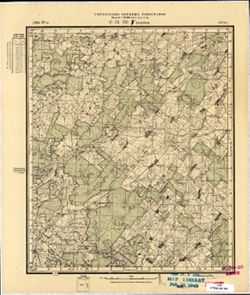
- Subject:
- Geographic Subject: Mlyniv, Topical Subject: Soviet Union, and Topical Subject: Maps
- Publisher:
- Управление военных топографов
- Language:
- Russian
- Date Created:
- 1937
- Identifier:
- VAC9619-000218
- Genre:
- Military Maps and Topographic Maps
- Geographic Location:
- Coordinates: 50.5, 25.5, 50.667, 25.75
- Related URL:
- Download GeoTIFF: https://drive.google.com/open?id=13uyKeOnyHt_42-Dl3iUUZgFJz7RZ1yEB and Catalog URL: http://iucat.iu.edu/catalog/5020131
- Abstract:
- Modern area represented: Mlyniv, Ukraine
- Call Number:
- G7000 s50 .S68 sheet M-35-52-A
- City:
- Млынув (Mlynuv)
- Copyright Holder:
- No Copyright - United States
- Country:
- Польша (Poland)
- Physical Description:
- Scale: 1:50,000
- Persistent URL:
- http://purl.dlib.indiana.edu/iudl/images/VAC9619/VAC9619-000218
- Provenance:
- DMA Topographic Center, Army Map Service Library, OMAHA, Library of Congress Geography & Map Division
-
- Description:
- 1873
- Subject:
- Topical Subject: Soviet Union, Geographic Subject: Joniškis, and Topical Subject: Maps
- Publisher:
- Управление военных топографов
- Language:
- Russian
- Date Created:
- 1898
- Identifier:
- VAC9619-001766
- Genre:
- Topographic Maps and Military Maps
- Geographic Location:
- Coordinates: 56.167, 23.5, 56.333, 23.75
- Related URL:
- Catalog URL: http://iucat.iu.edu/catalog/5020131 and Download GeoTIFF: https://drive.google.com/open?id=1OdRsbGC2STlWvnO5t7Q5u04OLoHAWgjo
- Abstract:
- Modern area represented: Joniškis, Lithuania
- Call Number:
- G7000 s50 .S68 sheet O-34-144-A
- City:
- Янишки (Joniškis)
- Copyright Holder:
- No Copyright - United States
- Country:
- Литва (Lithuania)
- Physical Description:
- Scale: 1:50,000
- Persistent URL:
- http://purl.dlib.indiana.edu/iudl/images/VAC9619/VAC9619-001766
- Provenance:
- M. I. Map Library
-
- Description:
- 1932
- Subject:
- Topical Subject: Maps, Geographic Subject: Озаринці (Ozaryntsi), and Topical Subject: Soviet Union
- Publisher:
- Управление военных топографов
- Language:
- Russian
- Identifier:
- VAC9619-000885
- Genre:
- Topographic Maps and Military Maps
- Geographic Location:
- Coordinates: 48.5, 27.75, 48.6667, 28
- Related URL:
- Download GeoTIFF: https://drive.google.com/open?id=1clJyxxJUBFb2ek9BOTxSGPGM9AB6GFfx and Catalog URL: http://iucat.iu.edu/catalog/5020131
- Abstract:
- Modern area represented: Озаринці (Ozaryntsi), Vinnytsia Oblast, Ukraine
- Call Number:
- G7000 s50 .S68 sheet M-35-128-B
- Caption:
- Captured map and Не подлежит оглашению
- City:
- Озаринцы (Ozarintsy)
- Copyright Holder:
- No Copyright - United States
- Country:
- СССР (USSR)
- State/Province:
- Украинская ССР (Ukrainian Soviet Socialist Republic) and Винницкая область (Vinnytsia oblast)
- Physical Description:
- Scale: 1:50,000
- Persistent URL:
- http://purl.dlib.indiana.edu/iudl/images/VAC9619/VAC9619-000885
- Provenance:
- DMA Topographic Center, Army Map Service Library, OMAHA, Library of Congress Geography & Map Division
-
- Description:
- 1929
- Subject:
- Topical Subject: Soviet Union, Topical Subject: Maps, and Geographic Subject: Vasyutyntsi
- Publisher:
- Управление военных топографов
- Language:
- Russian
- Identifier:
- VAC9619-001034
- Genre:
- Topographic Maps and Military Maps
- Geographic Location:
- Coordinates: 49.3333, 32.25, 49.5, 32.5
- Related URL:
- Catalog URL: http://iucat.iu.edu/catalog/5020131 and Download GeoTIFF: https://drive.google.com/open?id=160E9TKQjJHKCc_oTkIq5sN78-OifQaYB
- Abstract:
- Modern area represented: Васютинці (Vasyutyntsi), Cherkasy oblast, Ukraine
- Call Number:
- G7000 s50 .S68 sheet M-36-89-D
- Caption:
- Не подлежит оглашению (crossed out) and Рассекречено
- City:
- Васютинцы (Vasyutintsy)
- Copyright Holder:
- No Copyright - United States
- Country:
- СССР (USSR)
- State/Province:
- Украинская ССР (Ukrainian Soviet Socialist Republic)
- Physical Description:
- Scale: 1:50,000
- Persistent URL:
- http://purl.dlib.indiana.edu/iudl/images/VAC9619/VAC9619-001034
- Provenance:
- DMA Topographic Center, Army Map Service Library, OMAHA, Library of Congress Geography & Map Division
-
- Description:
- 1932
- Subject:
- Topical Subject: Soviet Union, Topical Subject: Maps, and Geographic Subject: Parevichi
- Publisher:
- Управление военных топографов
- Language:
- Russian
- Date Created:
- 1935
- Identifier:
- VAC9619-003528
- Genre:
- Topographic Maps and Military Maps
- Geographic Location:
- Coordinates: 57.3333, 30.25, 57.5, 30.5
- Related URL:
- Download GeoTIFF: https://drive.google.com/file/d/1XoJ_B73bclp0wAy4LtwTrHbzPBWOIEMp/view?usp=sharing and Catalog URL: http://iucat.iu.edu/catalog/5020131
- Abstract:
- Modern area represented: Паревичи (Parevichi), Pskovskaya oblast, Russia
- Call Number:
- GM G7000 s50 .S68 sheet O-36-85-D
- Caption:
- Не подлежит оглашению
- City:
- Паревичи (Parevichi)
- Copyright Holder:
- No Copyright - United States
- Country:
- СССР (USSR)
- State/Province:
- Ленинградская область (Leningrad oblast) and РСФСР (RSFSR)
- Physical Description:
- Scale: 1:50,000
- Persistent URL:
- http://purl.dlib.indiana.edu/iudl/images/VAC9619/VAC9619-003528
- Provenance:
- Army Map Service Library, OMAHA, Library of Congress Geography & Map Division
-
- Description:
- 1931
- Subject:
- Geographic Subject: Радалівка, Topical Subject: Soviet Union, Geographic Subject: Radalivka, and Topical Subject: Maps
- Publisher:
- Управление военных топографов
- Language:
- Russian
- Identifier:
- VAC9619-001040
- Genre:
- Topographic Maps and Military Maps
- Geographic Location:
- Coordinates: 49.5, 33.25, 49.6667, 33.5
- Related URL:
- Download GeoTIFF: https://drive.google.com/open?id=1Enk3MnyFeez4uCvtZQPGS3OzXGkZjL06 and Catalog URL: http://iucat.iu.edu/catalog/5020131
- Abstract:
- Modern area represented: Радалівка (Radalivka), Poltava oblast, Ukraine
- Call Number:
- G7000 s50 .S68 sheet M-36-91-B
- Caption:
- Не подлежит оглашению
- City:
- Радоловка (Radolovka)
- Copyright Holder:
- No Copyright - United States
- Country:
- СССР (USSR)
- State/Province:
- Украинская ССР (Ukrainian Soviet Socialist Republic)
- Physical Description:
- Scale: 1:50,000
- Persistent URL:
- http://purl.dlib.indiana.edu/iudl/images/VAC9619/VAC9619-001040
- Provenance:
- DMA Topographic Center, Army Map Service Library, OMAHA, Library of Congress Geography & Map Division
-
- Description:
- 1928
- Subject:
- Topical Subject: Maps, Topical Subject: Soviet Union, and Geographic Subject: Studenyky
- Publisher:
- Управление военных топографов
- Language:
- Russian
- Identifier:
- VAC9619-000978
- Genre:
- Military Maps and Topographic Maps
- Geographic Location:
- Coordinates: 50.167, 31.5, 50.333, 31.75
- Related URL:
- Download GeoTIFF: https://drive.google.com/open?id=1mFkjs4ZwqSZ_EiIAg_830EoD5IaKv275 and Catalog URL: http://iucat.iu.edu/catalog/5020131
- Abstract:
- Modern area represented: Студеники (Studenyky), Kyiv oblast, Ukraine
- Call Number:
- G7000 s50 .S68 sheet M-36-64-A
- Caption:
- Не подлежит оглашению
- City:
- Студеники (Studeniki)
- Copyright Holder:
- No Copyright - United States
- Country:
- СССР (USSR)
- State/Province:
- Украинская ССР (Ukrainian Soviet Socialist Republic)
- Physical Description:
- Scale: 1:50,000
- Persistent URL:
- http://purl.dlib.indiana.edu/iudl/images/VAC9619/VAC9619-000978
- Provenance:
- DMA Topographic Center, Army Map Service Library, Library of Congress Geography & Map Division
-
- Description:
- 1896
- Subject:
- Topical Subject: Maps, Topical Subject: Soviet Union, and Geographic Subject: Mažeikiai
- Publisher:
- Управление военных топографов
- Language:
- Russian
- Date Created:
- 1897
- Identifier:
- VAC9619-001764
- Genre:
- Topographic Maps and Military Maps
- Geographic Location:
- Coordinates: 56, 23, 56.167, 23.25
- Related URL:
- Catalog URL: http://iucat.iu.edu/catalog/5020131 and Download GeoTIFF: https://drive.google.com/open?id=1UzmO7gBvQAKv4GTAk8ecuNHfpnVwNalA
- Abstract:
- Modern area represented: Mažeikiai, Lithuania
- Call Number:
- G7000 s50 .S68 sheet O-34-143-C
- City:
- Можейки (Mažeikiai)
- Copyright Holder:
- No Copyright - United States
- Country:
- Литва (Lithuania)
- Physical Description:
- Scale: 1:50,000
- Persistent URL:
- http://purl.dlib.indiana.edu/iudl/images/VAC9619/VAC9619-001764
- Provenance:
- M. I. Map Library
-
- Description:
- 1928
- Subject:
- Geographic Subject: Борзна (Borzna), Topical Subject: Maps, and Topical Subject: Soviet Union
- Publisher:
- Управление военных топографов
- Language:
- Russian
- Identifier:
- VAC9619-000936
- Genre:
- Military Maps and Topographic Maps
- Geographic Location:
- Coordinates: 51.167, 32.25, 51.333, 32.5
- Related URL:
- Download GeoTIFF: https://drive.google.com/open?id=18xhNg6LcpIBkHFZKIxvC99q6RO41c9kY and Catalog URL: http://iucat.iu.edu/catalog/5020131
- Abstract:
- Modern area represented: Борзна (Borzna), Chernihiv oblast, Ukraine
- Call Number:
- G7000 s50 .S68 sheet M-36-27-B
- Caption:
- Не подлежит оглашению
- City:
- Борзна (Borzna)
- Copyright Holder:
- No Copyright - United States
- Country:
- СССР (USSR)
- State/Province:
- Украинская ССР (Ukrainian Soviet Socialist Republic)
- Physical Description:
- Scale: 1:50,000
- Persistent URL:
- http://purl.dlib.indiana.edu/iudl/images/VAC9619/VAC9619-000936
- Provenance:
- DMA Topographic Center, Army Map Service Library, OMAHA, Library of Congress Geography & Map Division
-
- Description:
- 1932
- Subject:
- Topical Subject: Soviet Union, Topical Subject: Maps, and Geographic Subject: Zapolye
- Publisher:
- Управление военных топографов
- Language:
- Russian
- Identifier:
- VAC9619-000056
- Genre:
- Topographic Maps and Military Maps
- Geographic Location:
- Coordinates: 57.3333, 30.5, 57.5, 30.75
- Related URL:
- Download GeoTIFF: https://drive.google.com/open?id=17_x28_Z_BDVfOkrBbY4QTkM7htZCIsu8 and Catalog URL: http://iucat.iu.edu/catalog/5020131
- Abstract:
- Modern area represented: Zapolye, Novgorod oblast, Russia
- Call Number:
- G7000 s50 .S68 sheet O-36-86-C
- Caption:
- Не подлежит оглашению
- City:
- Заполье (Zapolye)
- Copyright Holder:
- No Copyright - United States
- Country:
- СССР (USSR)
- State/Province:
- Ленинградская область (Leningrad oblast) and РСФСР (RSFSR)
- Physical Description:
- Scale: 1:50,000
- Persistent URL:
- http://purl.dlib.indiana.edu/iudl/images/VAC9619/VAC9619-000056
- Provenance:
- DMA Topographic Center, Army Map Service Library, OMAHA, Library of Congress Geography & Map Division
-
- Subject:
- Topical Subject: Soviet Union, Topical Subject: Maps, and Geographic Subject: Holoby
- Publisher:
- Управление военных топографов
- Language:
- Russian
- Identifier:
- VAC9619-000202
- Genre:
- Military Maps and Topographic Maps
- Geographic Location:
- Coordinates: 51, 25, 51.167, 25.25
- Related URL:
- Download GeoTIFF: https://drive.google.com/open?id=1adw_ENZ7am6VKEQzlA9qtW5NtHq3Iljx and Catalog URL: http://iucat.iu.edu/catalog/5020131
- Abstract:
- Modern area represented: Holoby, Volyn oblast, Ukraine
- Call Number:
- G7000 s50 .S68 sheet M-35-27-C
- City:
- Голобы (Hołoby)
- Copyright Holder:
- No Copyright - United States
- Country:
- Польша (Poland)
- Physical Description:
- Scale: 1:50,000
- Persistent URL:
- http://purl.dlib.indiana.edu/iudl/images/VAC9619/VAC9619-000202
- Provenance:
- DMA Topographic Center, Army Map Service Library, Library of Congress Geography & Map Division, OMAHA
-
- Description:
- 1923
- Subject:
- Topical Subject: Soviet Union, Geographic Subject: Lyëzna, and Topical Subject: Maps
- Publisher:
- Управление военных топографов
- Language:
- Russian
- Date Created:
- 1929
- Identifier:
- VAC9619-001259
- Genre:
- Military Maps and Topographic Maps
- Geographic Location:
- Coordinates: 55, 30.75, 55.167, 31
- Related URL:
- Catalog URL: http://iucat.iu.edu/catalog/5020131 and Download GeoTIFF: https://drive.google.com/open?id=1wwJUum2HZbDty6oLkHIQqNQllsH-yzXj
- Abstract:
- Modern area represented: Lyëzna, Vitebsk oblast, Belarus
- Call Number:
- GM G7000 S50 .S68 N-36-26-D
- Caption:
- Не подлежит оглашению
- City:
- Лиозно (Lyëzna)
- Copyright Holder:
- No Copyright - United States
- Country:
- СССР (USSR)
- State/Province:
- РСФСР (RSFSR), Западная область (Western oblast), and Белорусская ССР (Byelorussian Soviet Socialist Republic)
- Physical Description:
- Scale: 1:50,000
- Persistent URL:
- http://purl.dlib.indiana.edu/iudl/images/VAC9619/VAC9619-001259
- Provenance:
- Army Map Service Library, Library of Congress Geography & Map Division, OMAHA
-
- Description:
- 1931
- Subject:
- Geographic Subject: Lyudzyanyevichy, Topical Subject: Soviet Union, and Topical Subject: Maps
- Publisher:
- Управление военных топографов
- Language:
- Russian
- Identifier:
- VAC9619-000805
- Genre:
- Military Maps and Topographic Maps
- Geographic Location:
- Coordinates: 52.167, 27.5, 52.333, 27.75
- Related URL:
- Download GeoTIFF: https://drive.google.com/open?id=1Iz6igjqfubylUvJDRkPnaNLvnw66JNjs and Catalog URL: http://iucat.iu.edu/catalog/5020131
- Abstract:
- Modern area represented: Lyudzyanyevichy, Homyel oblast, Belarus
- Call Number:
- G7000 s50 .s68 sheet N-35-140-A
- Caption:
- Не подлежит оглашению
- City:
- Люденевичи (Lyudenevichi)
- Copyright Holder:
- No Copyright - United States
- Country:
- Польша (Poland) and СССР (USSR)
- State/Province:
- Белорусская ССР (Byelorussian Soviet Socialist Republic)
- Physical Description:
- Scale: 1:50,000
- Persistent URL:
- http://purl.dlib.indiana.edu/iudl/images/VAC9619/VAC9619-000805
- Provenance:
- DMA Topographic Center, Army Map Service Library, OMAHA, Library of Congress Geography & Map Division
-
- Description:
- 1891
- Subject:
- Topical Subject: Maps, Geographic Subject: Lopukhinka, and Topical Subject: Soviet Union
- Publisher:
- Управление военных топографов
- Language:
- Russian
- Date Created:
- 1930
- Identifier:
- VAC9619-001778
- Genre:
- Topographic Maps and Military Maps
- Geographic Location:
- Coordinates: 59.667, 29.25, 59.833, 29.5
- Related URL:
- Catalog URL: http://iucat.iu.edu/catalog/5020131 and Download GeoTIFF: https://drive.google.com/open?id=1ZRH4l3tn8j7xBdShk0pD3V3dk8MFcq7H
- Abstract:
- Modern area represented: Lopukhinka, Leningrad oblast, Russia
- Call Number:
- G7000 s50 .S68 sheet O-35-11-Г
- Caption:
- Не подлежит оглашению
- City:
- Лопухинка (Lopukhinka)
- Copyright Holder:
- No Copyright - United States
- Country:
- СССР (USSR)
- State/Province:
- РСФСР (RSFSR) and Ленинградская область (Leningrad oblast)
- Physical Description:
- Scale: 1:50,000
- Persistent URL:
- http://purl.dlib.indiana.edu/iudl/images/VAC9619/VAC9619-001778
- Provenance:
- Army Map Service Library, Library of Congress Geography & Map Division, OMAHA
-
- Description:
- 1929
- Subject:
- Geographic Subject: Якімавічы (Yakimavichy), Topical Subject: Soviet Union, and Topical Subject: Maps
- Publisher:
- Управление военных топографов
- Language:
- Russian
- Identifier:
- VAC9619-000828
- Genre:
- Military Maps and Topographic Maps
- Geographic Location:
- Coordinates: 52.167, 29, 52.333, 29.25
- Related URL:
- Catalog URL: http://iucat.iu.edu/catalog/5020131 and Download GeoTIFF: https://drive.google.com/open?id=1hW0JVK_txFGDjpfXu8G4PvC7QH-R8TTL
- Abstract:
- Modern area represented: Якімавічы (Yakimavichy), Homyel' oblast, Belarus
- Call Number:
- g7000 s50 .S68 sheet N-35-143-A
- Caption:
- Не подлежит оглашению
- City:
- Якимовичи (Yakimovichi)
- Copyright Holder:
- No Copyright - United States
- Country:
- СССР (USSR)
- State/Province:
- Белорусская ССР (Byelorussian Soviet Socialist Republic)
- Physical Description:
- Scale: 1:50,000
- Persistent URL:
- http://purl.dlib.indiana.edu/iudl/images/VAC9619/VAC9619-000828
- Provenance:
- Army Map Service Library, OMAHA, Library of Congress Geography & Map Division
-
- Subject:
- Topical Subject: Maps, Topical Subject: Soviet Union, and Geographic Subject: Şıxzahırlı
- Publisher:
- Управление военных топографов
- Language:
- Russian
- Identifier:
- VAC9619-000102
- Genre:
- Topographic Maps and Military Maps
- Geographic Location:
- Coordinates: 40.3333, 49, 40.5, 49.25
- Related URL:
- Catalog URL: http://iucat.iu.edu/catalog/5020131 and Download GeoTIFF: https://drive.google.com/open?id=1whAXNIk9XmsAjVmpnbtT68C6DFI6K3M5
- Abstract:
- Modern area represented: Şıxzahırlı, Azerbaijan
- Call Number:
- G7000 s50 .S68 sheet K-39-123-C
- Caption:
- Не подлежит оглашению
- City:
- Ших-Загирли (Shikh-Zagirli)
- Copyright Holder:
- No Copyright - United States
- Country:
- СССР (USSR)
- State/Province:
- Азербайджанская ССР (Azerbaijan Soviet Socialist Republic)
- Physical Description:
- Scale: 1:50,000
- Persistent URL:
- http://purl.dlib.indiana.edu/iudl/images/VAC9619/VAC9619-000102
- Provenance:
- DMA Topographic Center, Army Map Service Library, OMAHA, Library of Congress Geography & Map Division
