
Search Constraints
« Previous |
1 - 10 of 50
|
Next »
Search Results
-
- Description:
- 1874
- Subject:
- Topical Subject: Soviet Union, Geographic Subject: Hryhoriopol, and Topical Subject: Maps
- Publisher:
- Генеральный штаб РККА
- Language:
- Russian
- Date Created:
- 1916
- Identifier:
- VAC9619-001531
- Genre:
- Military Maps and Topographic Maps
- Geographic Location:
- Coordinates: 47, 29, 47.3333, 29.5
- Related URL:
- Download GeoTIFF: https://drive.google.com/open?id=19E1iGxfkWQpzLaVEysUOs-ieDNfm5LYO and Catalog URL: https://iucat.iu.edu/catalog/5020129
- Abstract:
- Modern area represented: Hryhoriopol, Stînga Nistrului, Moldova
- Call Number:
- G7000 s100 .S7 sheet L-35-35
- Caption:
- Не подлежит оглашению
- City:
- Григориополь (Hryhoriopol)
- Copyright Holder:
- No Copyright - United States
- State/Province:
- Бессарабия (Bessarabia), Молдавская АССР (Moldavian Autonomous Soviet Socialist Republic), and Украинская ССР (Ukrainian Soviet Socialist Republic)
- Physical Description:
- Scale: 1:100,000
- Persistent URL:
- http://purl.dlib.indiana.edu/iudl/images/VAC9619/VAC9619-001531
- Provenance:
- DMA Topographic Center, Army Map Service Library, Library of Congress Geography & Map Division
-
- Description:
- 1874
- Subject:
- Geographic Subject: Chisinau, Topical Subject: Maps, and Topical Subject: Soviet Union
- Publisher:
- Генеральный штаб РККА
- Language:
- Russian
- Date Created:
- 1916
- Identifier:
- VAC9619-001530
- Genre:
- Military Maps and Topographic Maps
- Geographic Location:
- Coordinates: 47, 28.5, 47.3333, 29
- Related URL:
- Download GeoTIFF: https://drive.google.com/open?id=1xHhtT8h9OlNdn0pYOldU3_y0HXwzxGxP and Catalog URL: https://iucat.iu.edu/catalog/5020129
- Abstract:
- Modern area represented: Chisinau, Chișinău municipality, Moldova
- Call Number:
- G7000 s100 .S7 sheet L-35-34
- City:
- Кишинев (Kischinew)
- Copyright Holder:
- No Copyright - United States
- State/Province:
- Бессарабия (Bessarabia)
- Physical Description:
- Scale: 1:100,000
- Persistent URL:
- http://purl.dlib.indiana.edu/iudl/images/VAC9619/VAC9619-001530
- Provenance:
- DMA Topographic Center, Army Map Service Library, OMAHA, Library of Congress Geography & Map Division, Reichsamt für Landesaufnahme, Kartensammlung
-
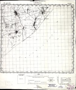
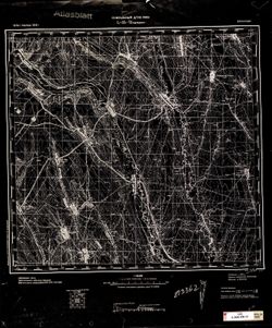
- Description:
- 1884
- Subject:
- Topical Subject: Maps, Topical Subject: Soviet Union, and Geographic Subject: Shyroke
- Publisher:
- Генеральный штаб Красной Армии
- Language:
- Russian
- Date Created:
- 1916
- Identifier:
- VAC9619-001926
- Genre:
- Military Maps and Topographic Maps
- Geographic Location:
- Coordinates: 45.6667, 30, 46, 30.5
- Related URL:
- Download GeoTIFF: https://drive.google.com/file/d/1AYaNyRovEw9oylsdtjC4JxGB1IgJmmQs/view?usp=sharing and Catalog URL: https://iucat.iu.edu/catalog/5020129
- Abstract:
- Modern area represented: Shyroke, Odessa oblast, Ukraine
- Call Number:
- G7000 s100 .S7 sheet L-36-73
- Caption:
- Для служебного пользования
- City:
- Кебабча (Kebabcha)
- Copyright Holder:
- No Copyright - United States
- Country:
- СССР (USSR)
- State/Province:
- Украинская ССР (Ukrainian Soviet Socialist Republic) and Аккерманская область (Akkerman oblast)
- Physical Description:
- Scale: 1:100,000
- Persistent URL:
- http://purl.dlib.indiana.edu/iudl/images/VAC9619/VAC9619-001926
- Provenance:
- DMA Topographic Center, Army Map Service Library, OMAHA
-
- Description:
- 1884
- Subject:
- Geographic Subject: Shyroke, Topical Subject: Soviet Union, and Topical Subject: Maps
- Publisher:
- Управление военных топографов РККА
- Language:
- Russian
- Date Created:
- 1916
- Identifier:
- VAC9619-001925
- Genre:
- Military Maps and Topographic Maps
- Geographic Location:
- Coordinates: 45.6667, 30, 46, 30.5
- Related URL:
- Download GeoTIFF: https://drive.google.com/open?id=1iPfmTs__rEimlzKp73T30v5fMa4py_Lz and Catalog URL: https://iucat.iu.edu/catalog/5020129
- Abstract:
- Modern area represented: Shyroke, Odessa oblast, Ukraine
- Call Number:
- G7000 s100 .S7 sheet L-36-73
- City:
- Кебабча (Kebabcha)
- Copyright Holder:
- No Copyright - United States
- State/Province:
- Бессарабия (Bessarabia)
- Physical Description:
- Scale: 1:100,000
- Persistent URL:
- http://purl.dlib.indiana.edu/iudl/images/VAC9619/VAC9619-001925
- Provenance:
- CIA Map Library
-
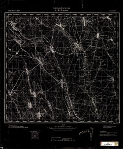
- Description:
- 1877
- Subject:
- Topical Subject: Soviet Union, Topical Subject: Maps, and Geographic Subject: Strumok
- Publisher:
- Генеральный штаб РККА
- Language:
- Russian
- Date Created:
- 1916
- Identifier:
- VAC9619-001668
- Genre:
- Topographic Maps and Military Maps
- Geographic Location:
- Coordinates: 45.6667, 29, 46, 29.5
- Related URL:
- Download GeoTIFF: https://drive.google.com/open?id=1NH1x6hcaWJYBTNtwSqN67ONFP7RSfUJk and Catalog URL: https://iucat.iu.edu/catalog/5020129
- Abstract:
- Modern area represented: Strumok, Odessa oblast, Ukraine
- Call Number:
- G7000 s100 .S7 sheet L-35-83
- City:
- Чишмеле (Cişmele)
- Copyright Holder:
- No Copyright - United States
- State/Province:
- Бессарабия (Bessarabia)
- Physical Description:
- Scale: 1:100,000
- Persistent URL:
- http://purl.dlib.indiana.edu/iudl/images/VAC9619/VAC9619-001668
- Provenance:
- DMA Topographic Center, Army Map Service Library, OMAHA, Atlasblatt, Library of Congress Geography & Map Division
-
- Description:
- 1875
- Subject:
- Topical Subject: Maps, Geographic Subject: Berezyne, and Topical Subject: Soviet Union
- Publisher:
- Генеральный штаб РККА
- Language:
- Russian
- Date Created:
- 1916
- Identifier:
- VAC9619-001635
- Genre:
- Topographic Maps and Military Maps
- Geographic Location:
- Coordinates: 46, 29, 46.3333, 29.5
- Related URL:
- Catalog URL: https://iucat.iu.edu/catalog/5020129 and Download GeoTIFF: https://drive.google.com/file/d/1V5InYbVyYfed6G5yI-n23wDGBkHEh0Rn/view?usp=sharing
- Abstract:
- Modern area represented: Berezyne, Odessa oblast, Ukraine.
- Call Number:
- G7000 s100 .S7 sheet L-35-71
- City:
- Березина (Berezyne)
- Copyright Holder:
- No Copyright - United States
- Country:
- СССР (USSR)
- State/Province:
- Бессарабия (Bessarabia)
- Physical Description:
- Scale: 1:100,000
- Persistent URL:
- http://purl.dlib.indiana.edu/iudl/images/VAC9619/VAC9619-001635
- Provenance:
- CIA Map Library, Atlasblatt
-
- Description:
- 1875
- Subject:
- Topical Subject: Maps, Topical Subject: Soviet Union, and Geographic Subject: Berezyne
- Publisher:
- Генеральный штаб РККА
- Language:
- Russian
- Date Created:
- 1916
- Identifier:
- VAC9619-001629
- Genre:
- Military Maps and Topographic Maps
- Geographic Location:
- Coordinates: 46, 29, 46.3333, 29.5
- Related URL:
- Catalog URL: https://iucat.iu.edu/catalog/5020129 and Download GeoTIFF: https://drive.google.com/open?id=1C3sEntFJccgyBICFoDtKC-3pwp46wFsk
- Abstract:
- Modern area represented: Berezyne, Odessa oblast, Ukraine.
- Call Number:
- G7000 s100 .S7 sheet L-35-71
- City:
- Березина (Berezyne)
- Copyright Holder:
- No Copyright - United States
- Country:
- СССР (USSR)
- State/Province:
- Бессарабия (Bessarabia)
- Physical Description:
- Scale: 1:100,000
- Persistent URL:
- http://purl.dlib.indiana.edu/iudl/images/VAC9619/VAC9619-001629
- Provenance:
- CIA Map Library
-
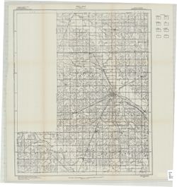
- Subject:
- Geographic Subject: Wells County (Ind.), Topical Subject: IGS Annual Reports, and Topical Subject: Soils
- Creator:
- United States. Bureau of Soils, Tharp, W. E. (William Edgar), and Wiley, W. E. (William Emmett), 1894-1967
- Publisher:
- Indiana. Department of Geology and Natural Resources
- Date Created:
- 1916
- Identifier:
- VAC3073-M-01537
- Genre:
- Thematic maps
- Geographic Location:
- Coordinates: W0852656 W0850406 N0405504 N0403400
- Related URL:
- Catalog URL: https://iucat.iu.edu/catalog/16138560
- Abstract:
- "Field Operations, Bureau of Soils, 1915." Detached from: Soil survey of Wells County / W. E. Tharp and W. E. Wiley. In Fortieth annual report o...
- Call Number:
- G4093.W7J3 1915 .T49
- Caption:
- Imprint: [Fort Wayne]: [Fort Wayne Printing Company], [1916] and Imprint: [Indianapolis] : State of Indiana, Department of Geology, [1916]
- Physical Description:
- Dimensions: 58 x 48 cm and Scale: 1:63,360. 1 in. = 1 mile
- Alternate Identifier:
- Title Control Number: a16138560 and Alternate ID: 390726IP
- Persistent URL:
- https://purl.dlib.indiana.edu/iudl/images/VAC3073/VAC3073-M-01537
- Provenance:
- 40th Annual Report (1915) / Indiana. Department of Geology and Natural Resources.
-
- Subject:
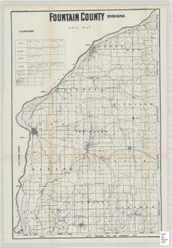
- Topical Subject: Mines and mineral resources, Topical Subject: Geology, Geographic Subject: Fountain County (Ind.), and Topical Subject: IGS Annual Reports
- Creator:
- Indiana. Department of Geology and Natural Resources
- Date Created:
- 1916
- Identifier:
- VAC3073-M-01529
- Genre:
- Thematic maps
- Related URL:
- Catalog URL: https://iucat.iu.edu/catalog/4022273
- Call Number:
- QE109 .A2 1915
- Persistent URL:
- https://purl.dlib.indiana.edu/iudl/images/VAC3073/VAC3073-M-01529
-
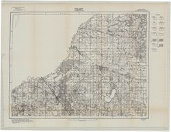
- Subject:
- Topical Subject: Soils and Geographic Subject: Starke County (Ind.)
- Creator:
- Grimes, E. J. (Earl Jerome)
- Publisher:
- Indiana. Department of Geology
- Date Created:
- 1916
- Identifier:
- VAC3073-M-01512
- Genre:
- Thematic maps
- Geographic Location:
- Coordinates: W0865548 W0862758 N0412558 N0411016
- Related URL:
- Catalog URL: https://iucat.iu.edu/catalog/16144189
- Abstract:
- Detached from: Soil survey of Starke County, Indiana / E.J. Grimes, Wendell Barrett, and T.M. Bushnell. In 40th Annual report of Department of Geology and Na...
- Call Number:
- G4093.S6J3 1915 .G76
- Caption:
- Imprint: [Indianapolis] : State of Indiana, Department of Geology, [1916]
- Physical Description:
- Scale: 1:63,360
- Persistent URL:
- https://purl.dlib.indiana.edu/iudl/images/VAC3073/VAC3073-M-01512
- Provenance:
- 40th Annual Report (1915) / Indiana. Department of Geology and Natural Resources.
