
Search Constraints
You searched for:
State/Province
РСФСР (RSFSR)
Remove constraint State/Province: РСФСР (RSFSR)
« Previous |
1 - 10 of 1,385
|
Next »
Search Results
-
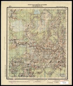
- Description:
- 1927
- Subject:
- Geographic Subject: Nelidovo, Topical Subject: Soviet Union, and Topical Subject: Maps
- Publisher:
- Военно-топографическое управление
- Language:
- Russian
- Identifier:
- VAC9619-003499
- Genre:
- Military Maps and Topographic Maps
- Geographic Location:
- Coordinates: 56.167, 32.75, 56.333, 33
- Related URL:
- Download GeoTIFF: https://drive.google.com/file/d/1lyldTXRTAWh4xkvxGY4qHYiAm3I1vIe8/view?usp=sharing and Catalog URL: http://iucat.iu.edu/catalog/5020131
- Abstract:
- Modern area represented: Нелидово (Nelidovo), Tverskaya oblast, Russia
- Call Number:
- G7000 s50 .S68 sheet O-36-138-B
- Caption:
- Секретно
- City:
- Нелидово (Nelidovo)
- Copyright Holder:
- No Copyright - United States
- Country:
- СССР (USSR)
- State/Province:
- РСФСР (RSFSR) and Западная область (Western oblast)
- Physical Description:
- Scale: 1:50,000
- Persistent URL:
- http://purl.dlib.indiana.edu/iudl/images/VAC9619/VAC9619-003499
- Provenance:
- Army Map Service Library, OMAHA, Library of Congress Geography & Map Division
-
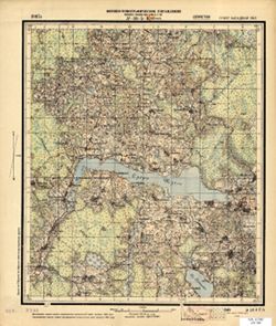
- Description:
- 1927
- Subject:
- Topical Subject: Soviet Union, Geographic Subject: Shoptovo, and Topical Subject: Maps
- Publisher:
- Военно-топографическое управление
- Language:
- Russian
- Identifier:
- VAC9619-003504
- Genre:
- Topographic Maps and Military Maps
- Geographic Location:
- Coordinates: 56.0, 33.0, 56.16667, 33.25
- Related URL:
- Catalog URL: http://iucat.iu.edu/catalog/5020131 and Download GeoTIFF: https://drive.google.com/file/d/1jBZ7c8YBwoL20pu6vc6Qs9-_gZvQX4Sd/view?usp=sharing
- Abstract:
- Modern area represented: Шоптово (Shoptovo), Tverskaya oblast, Russia
- Call Number:
- GM G7000 s50 .S68 sheet O-36-139-C
- City:
- Шопотово (Shopotovo)
- Copyright Holder:
- No Copyright - United States
- Country:
- СССР (USSR)
- State/Province:
- РСФСР (RSFSR) and Западная область (Western oblast)
- Physical Description:
- Scale: 1:50,000
- Persistent URL:
- http://purl.dlib.indiana.edu/iudl/images/VAC9619/VAC9619-003504
- Provenance:
- CIA Map Library
-

- Description:
- 1938
- Subject:
- Topical Subject: Maps, Geographic Subject: Krasnogvardeyskoe, and Topical Subject: Soviet Union
- Publisher:
- Главное управление геодезии и картографии при СНК СССР
- Language:
- Russian
- Date Created:
- 1941
- Identifier:
- VAC9619-002343
- Genre:
- Topographic Maps and Military Maps
- Geographic Location:
- Coordinates: 45.667, 41.5, 46, 42
- Related URL:
- Download GeoTIFF: https://drive.google.com/file/d/1AVr-cwCpH2TyChEw-jxKdVkFJnNQ8ff2/view?usp=sharing and Catalog URL: https://iucat.iu.edu/catalog/5020129
- Abstract:
- Modern area represented: Krasnogvardeyskoe, Stavropol kray, Russia
- Call Number:
- G7000 s100 .S7 sheet L-37-84
- Caption:
- Для служебного пользования
- City:
- Молотовское (Molotovskoe)
- Copyright Holder:
- No Copyright - United States
- Country:
- СССР (USSR)
- State/Province:
- Орджоникидзевский край (Ordzhonikidze kray), Калмыцкая АССР (Kalmyk Autonomous Soviet Socialist Republic), Ростовская область (Rostov oblast), and РСФСР (RSFSR)
- Physical Description:
- Scale: 1:100,000
- Persistent URL:
- http://purl.dlib.indiana.edu/iudl/images/VAC9619/VAC9619-002343
- Provenance:
- DMA Topographic Center, Army Map Service Library, OMAHA
-
- Description:
- 1927
- Subject:
- Topical Subject: Maps, Geographic Subject: Tyntsy, and Topical Subject: Soviet Union
- Publisher:
- Управление военных топографов РККА
- Language:
- Russian
- Identifier:
- VAC9619-002272
- Genre:
- Military Maps and Topographic Maps
- Geographic Location:
- Coordinates: 56.3333, 40.5, 56.6667, 41
- Related URL:
- Download GeoTIFF: https://drive.google.com/file/d/102D4vu1uG3HlLnspP2zmEKvXMZnMEkAk/view?usp=sharing and Catalog URL: https://iucat.iu.edu/catalog/5020129
- Abstract:
- Modern area represented: Тынцы (Tyntsy), Vladimirskaya oblast, Russia
- Call Number:
- G7000 s100 .S7 sheet O-37-130
- City:
- Тынцы (Tyntsy)
- Copyright Holder:
- No Copyright - United States
- Country:
- СССР (USSR)
- State/Province:
- РСФСР (RSFSR) and Ивановская область (Ivanovo oblast)
- Physical Description:
- Scale: 1:100,000
- Persistent URL:
- http://purl.dlib.indiana.edu/iudl/images/VAC9619/VAC9619-002272
- Provenance:
- DMA Topographic Center, Army Map Service Library
-
- Description:
- 1927
- Subject:
- Topical Subject: Maps, Topical Subject: Soviet Union, and Geographic Subject: Shchuchye
- Publisher:
- Военно-топографическое управление
- Language:
- Russian
- Identifier:
- VAC9619-001198
- Genre:
- Military Maps and Topographic Maps
- Geographic Location:
- Coordinates: 55.6667, 32, 55.8333, 32.25
- Related URL:
- Download GeoTIFF: https://drive.google.com/open?id=147RGpw0Na2siN-y2rk7SMsc9WXSSvCjn and Catalog URL: http://iucat.iu.edu/catalog/5020131
- Abstract:
- Modern area represented: Shchuchye, Tver oblast, Russia
- Call Number:
- GM G7000 S50 .S68 N-36-5-B
- Caption:
- Секретно
- City:
- Щучье (Shchuchye)
- Copyright Holder:
- No Copyright - United States
- Country:
- СССР (USSR)
- State/Province:
- Западная область (Western oblast) and РСФСР (RSFSR)
- Physical Description:
- Scale: 1:50,000
- Persistent URL:
- http://purl.dlib.indiana.edu/iudl/images/VAC9619/VAC9619-001198
- Provenance:
- Library of Congress Geography & Map Division
-

- Description:
- 1939
- Subject:
- Topical Subject: Maps, Geographic Subject: Yukhnov, and Topical Subject: Soviet Union
- Publisher:
- Генеральный штаб Красной Армии
- Language:
- Russian
- Date Created:
- 1941
- Identifier:
- VAC9619-004187
- Genre:
- Topographic Maps and Military Maps
- Geographic Location:
- Coordinates: 54.667, 35, 55, 35.5
- Related URL:
- Download GeoTIFF: https://drive.google.com/file/d/1cQNBivSSzsjyVCwoyr6v2BrCZDWttVf4/view?usp=sharing and Catalog URL: https://iucat.iu.edu/catalog/5020129
- Abstract:
- Modern area represented: Yukhnov, Kaluga oblast, Russia
- Call Number:
- G7000 s100 .S7 sheet N-36-47
- City:
- Юхнов (Yukhnov)
- Copyright Holder:
- No Copyright - United States
- Country:
- СССР (USSR)
- State/Province:
- Смоленская область (Smolensk oblast) and РСФСР (RSFSR)
- Physical Description:
- Scale: 1:100,000
- Persistent URL:
- http://purl.dlib.indiana.edu/iudl/images/VAC9619/VAC9619-004187
- Provenance:
- DMA Topographic Center, Army Map Service Library, OMAHA
-

- Description:
- 1937
- Subject:
- Geographic Subject: Gummolovo and Topical Subject: Soviet Union
- Publisher:
- Главное управление государственной съемки и картографии НКВД СССР
- Language:
- Russian
- Date Created:
- 1941
- Identifier:
- VAC9619-000040
- Genre:
- Military Maps and Topographic Maps
- Geographic Location:
- Coordinates: 59.1667, 30.75, 59.3333, 31
- Related URL:
- Catalog URL: http://iucat.iu.edu/catalog/5020131 and Download GeoTIFF: https://drive.google.com/open?id=1Thglq8S3ntpZfPmHWFNFQ1QHmQpoR5Lu
- Abstract:
- Modern area represented: Gummolovo, Russia
- Call Number:
- G7000 s50 .S68 sheet O-36-26-B
- Caption:
- Для служебного пользования
- City:
- Гуммолово (Gummolovo)
- Copyright Holder:
- No Copyright - United States
- Country:
- СССР (USSR)
- State/Province:
- Ленинградская область (Leningrad oblast), Тосненский район (Tosnensky district), and РСФСР (RSFSR)
- Physical Description:
- Scale: 1:50,000
- Persistent URL:
- http://purl.dlib.indiana.edu/iudl/images/VAC9619/VAC9619-000040
- Provenance:
- Army Map Service Library, OMAHA, Library of Congress Geography & Map Division
-
- Description:
- 1929
- Subject:
- Geographic Subject: Kamenka, Topical Subject: Soviet Union, and Topical Subject: Maps
- Publisher:
- Военно-топографическое управление
- Language:
- Russian
- Identifier:
- VAC9619-003544
- Genre:
- Topographic Maps and Military Maps
- Geographic Location:
- Coordinates: 57.167, 31, 57.333, 31.25
- Related URL:
- Download GeoTIFF: https://drive.google.com/file/d/1lmBNnLm3Poz1CI8n_BfSwm8NcQNlU4M-/view?usp=sharing and Catalog URL: http://iucat.iu.edu/catalog/5020131
- Abstract:
- Modern area represented: Каменка (Kamenka), Novgorodskaya oblast, Russia
- Call Number:
- GM G7000 s50 .S68 sheet O-36-99-A
- Caption:
- Не подлежит оглашению
- City:
- Каменка (Kamenka)
- Copyright Holder:
- No Copyright - United States
- Country:
- СССР (USSR)
- State/Province:
- РСФСР (RSFSR), Западная область (Western oblast), and Ленинградская область (Leningrad oblast)
- Physical Description:
- Scale: 1:50,000
- Persistent URL:
- http://purl.dlib.indiana.edu/iudl/images/VAC9619/VAC9619-003544
- Provenance:
- DMA Topographic Center, Army Map Service Library, Library of Congress Geography & Map Division
-

- Description:
- 1933
- Subject:
- Topical Subject: Soviet Union, Geographic Subject: Taman, and Topical Subject: Maps
- Publisher:
- Генеральный штаб Красной Армии
- Language:
- Russian
- Date Created:
- 1941
- Identifier:
- VAC9619-002358
- Genre:
- Topographic Maps and Military Maps
- Geographic Location:
- Coordinates: 45, 36.5, 45.333, 37
- Related URL:
- Download GeoTIFF: https://drive.google.com/file/d/1X763anMOD-wQf-npLvv0Rk-_nGzkuqHb/view?usp=sharing and Catalog URL: https://iucat.iu.edu/catalog/5020129
- Abstract:
- Modern area represented: Taman, Russia
- Call Number:
- G7000 s100 .S7 sheet L-37-98
- Caption:
- Для служебного пользования
- City:
- Тамань (Taman)
- Copyright Holder:
- No Copyright - United States
- Country:
- СССР (USSR)
- State/Province:
- РСФСР (RSFSR) and Краснодарский край (Krasnodar kray)
- Physical Description:
- Scale: 1:100,000
- Persistent URL:
- http://purl.dlib.indiana.edu/iudl/images/VAC9619/VAC9619-002358
- Provenance:
- DMA Topographic Center, Army Map Service Library, Library of Congress Geography & Map Division
-
- Description:
- 1927
- Subject:
- Topical Subject: Soviet Union, Topical Subject: Maps, and Geographic Subject: Tarzhepol'
- Publisher:
- Главное геодезическое управление
- Language:
- Russian
- Identifier:
- VAC9619-002556
- Genre:
- Topographic Maps and Military Maps
- Geographic Location:
- Coordinates: 61, 34, 61.333, 34.5
- Related URL:
- Catalog URL: https://iucat.iu.edu/catalog/5020129 and Download GeoTIFF: https://drive.google.com/file/d/1znEaZC6LKaPd3LRQXlzjNsGvDf9zhkGm/view?usp=sharing
- Abstract:
- Modern area represented: Таржеполь (Tarzhepol’), Republic of Karelia, Russia
- Call Number:
- G7000 s100 .S7 sheet P-36-105
- Caption:
- Не подлежит оглашению
- City:
- Таржеполь (Tarzhepol’)
- Copyright Holder:
- No Copyright - United States
- Country:
- СССР (USSR)
- State/Province:
- Ленинградская область (Leningrad oblast), РСФСР (RSFSR), and Карельская АССР (Karelian Autonomous Soviet Socialist Republic)
- Physical Description:
- Scale: 1:100,000
- Persistent URL:
- http://purl.dlib.indiana.edu/iudl/images/VAC9619/VAC9619-002556
- Provenance:
- DMA Topographic Center, Army Map Service Library, OMAHA
