
Search Constraints
You searched for:
Date Created
1930
Remove constraint Date Created: 1930
Publisher
Генеральный штаб РККА
Remove constraint Publisher: Генеральный штаб РККА
« Previous |
1 - 10 of 20
|
Next »
Search Results
-
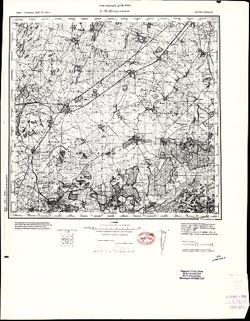
- Description:
- 1884
- Subject:
- Geographic Subject: Lomza, Topical Subject: Soviet Union, and Topical Subject: Maps
- Publisher:
- Генеральный штаб РККА
- Language:
- Russian
- Date Created:
- 1930
- Identifier:
- VAC9619-004003
- Genre:
- Military Maps and Topographic Maps
- Geographic Location:
- Coordinates: 53, 22, 53.333, 22.5
- Related URL:
- Download GeoTIFF: https://drive.google.com/file/d/1oIYQOvf9T9bGlBoG0SMFcZh7VIar6p8C/view?usp=sharing and Catalog URL: https://iucat.iu.edu/catalog/5020129
- Abstract:
- Modern area represented: Lomza, Podlaskie Voivodeship, Poland
- Call Number:
- G7000 s100 .S7 sheet N-34-105
- City:
- Ломжа (Lomza)
- Copyright Holder:
- No Copyright - United States
- Country:
- Польша (Poland)
- Physical Description:
- Scale: 1:100,000
- Persistent URL:
- http://purl.dlib.indiana.edu/iudl/images/VAC9619/VAC9619-004003
- Provenance:
- DMA Topographic Center, Army Map Service Library, OMAHA
-
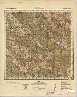
- Description:
- 1928
- Subject:
- Topical Subject: Maps, Geographic Subject: Odessa, and Topical Subject: Soviet Union
- Publisher:
- Генеральный штаб РККА
- Language:
- Russian
- Date Created:
- 1930
- Identifier:
- VAC9619-001903
- Genre:
- Topographic Maps and Military Maps
- Geographic Location:
- Coordinates: 46.3333, 30.5, 46.6667, 31
- Related URL:
- Download GeoTIFF: https://drive.google.com/open?id=1gLL-JxmNGbuz-u1gNxeqgZ8NbWRxc8g2 and Catalog URL: https://iucat.iu.edu/catalog/5020129
- Abstract:
- Modern area represented: Odessa, Odessa oblast, Ukraine
- Call Number:
- G7000 s100 .S7 sheet L-36-50
- Caption:
- Не подлежит оглашению
- City:
- Одесса (Odessa)
- Copyright Holder:
- No Copyright - United States
- Country:
- СССР (USSR)
- State/Province:
- Одесская область (Odessa oblast) and Украинская ССР (Ukrainian Soviet Socialist Republic)
- Physical Description:
- Scale: 1:100,000
- Persistent URL:
- http://purl.dlib.indiana.edu/iudl/images/VAC9619/VAC9619-001903
- Provenance:
- CIA Map Library
-
- Description:
- 1893
- Subject:
- Topical Subject: Maps, Topical Subject: Soviet Union, and Geographic Subject: Bolshoye Kuzemkino
- Publisher:
- Генеральный штаб РККА
- Language:
- Russian
- Date Created:
- 1930
- Identifier:
- VAC9619-000011
- Genre:
- Topographic Maps and Military Maps
- Geographic Location:
- Coordinates: 59.5, 28, 59.667, 28.25
- Related URL:
- Catalog URL: http://iucat.iu.edu/catalog/5020131 and Download GeoTIFF: https://drive.google.com/open?id=1nqLKDCsAThqjIx8GW9P4AB9M9wcg8C66
- Abstract:
- Modern area represented: Bolshoye Kuzemkino, Leningrad oblast, Russia
- Call Number:
- zsheet O-35-21-A and G7000 s50 .S68
- Caption:
- Не подлежит оглашению
- City:
- Бол. Куземкино (Bolshoye Kuzemkino)
- Copyright Holder:
- No Copyright - United States
- Country:
- Эстония (Estonia) and СССР (USSR)
- State/Province:
- РСФСР (RSFSR) and Ленинградская область (Leningrad oblast)
- Physical Description:
- Scale: 1:50,000
- Persistent URL:
- http://purl.dlib.indiana.edu/iudl/images/VAC9619/VAC9619-000011
- Provenance:
- M. I. Map Library, Atlasblatt, GS, RA
-
- Description:
- 1910
- Subject:
- Topical Subject: Maps, Geographic Subject: Budsław, and Topical Subject: Soviet Union
- Publisher:
- Генеральный штаб РККА
- Language:
- Russian
- Date Created:
- 1930
- Identifier:
- VAC9619-004045
- Genre:
- Military Maps and Topographic Maps
- Geographic Location:
- Coordinates: 54.667, 27, 55, 27.5
- Related URL:
- Catalog URL: https://iucat.iu.edu/catalog/5020129 and Download GeoTIFF: https://drive.google.com/file/d/14qh0_HR2_iLnZGYebT5_sip_B1pLZikd/view?usp=sharing
- Abstract:
- Modern area represented: Budsław, Belarus
- Call Number:
- G7000 s100 .S7 sheet N-35-43
- City:
- Будслав (Budsław)
- Copyright Holder:
- No Copyright - United States
- Country:
- СССР (USSR)
- State/Province:
- Белорусская ССР (Byelorussian Soviet Socialist Republic)
- Physical Description:
- Scale: 1:100,000
- Persistent URL:
- http://purl.dlib.indiana.edu/iudl/images/VAC9619/VAC9619-004045
- Provenance:
- DMA Topographic Center, Army Map Service Library, Auswärtiges Amt. Geographischer Dienst
-
- Description:
- 1884
- Subject:
- Topical Subject: Maps, Geographic Subject: Valea lui Mihai, and Topical Subject: Soviet Union
- Publisher:
- Генеральный штаб РККА
- Language:
- Russian
- Date Created:
- 1930
- Identifier:
- VAC9619-000782
- Genre:
- Military Maps and Topographic Maps
- Geographic Location:
- Coordinates: 47.3333, 22, 47.6667, 22.5
- Related URL:
- Catalog URL: https://iucat.iu.edu/catalog/5020129 and Download GeoTIFF: https://drive.google.com/open?id=1CRzaW5Rk97ndXjhrNAiwsNpLwNOkc60K
- Abstract:
- Modern area represented: Valea lui Mihai, Bihor county, Romania
- Call Number:
- G7000 s100 .S7 sheet L-34-21
- City:
- Валеа-Луй-Михай (Valea lui Mihai)
- Copyright Holder:
- No Copyright - United States
- Country:
- Венгрия (Hungary) and Румыния (Romania)
- Physical Description:
- Scale: 1:100,000
- Persistent URL:
- http://purl.dlib.indiana.edu/iudl/images/VAC9619/VAC9619-000782
- Provenance:
- CIA Map Library, Library of Congress Geography & Map Division
-
- Description:
- 1913
- Subject:
- Topical Subject: Maps, Geographic Subject: Krāslava, and Topical Subject: Soviet Union
- Publisher:
- Генеральный штаб РККА
- Language:
- Russian
- Date Created:
- 1930
- Identifier:
- VAC9619-004009
- Genre:
- Topographic Maps and Military Maps
- Geographic Location:
- Coordinates: 55.667, 27, 56, 27.5
- Related URL:
- Catalog URL: https://iucat.iu.edu/catalog/5020129 and Download GeoTIFF: https://drive.google.com/file/d/12N6kf5hWYLgmEFN-uQGVmIYt7tuSBHGk/view?usp=sharing
- Abstract:
- Modern area represented: Krāslava, Krāslavas novads, Latvia
- Call Number:
- G7000 s100 .S7 sheet N-35-7
- City:
- Крааслава (Krāslava)
- Copyright Holder:
- No Copyright - United States
- Country:
- Латвия (Latvia) and Польша (Poland)
- Physical Description:
- Scale: 1:100,000
- Persistent URL:
- http://purl.dlib.indiana.edu/iudl/images/VAC9619/VAC9619-004009
- Provenance:
- DMA Topographic Center, Army Map Service Library, OMAHA, Library of Congress Geography & Map Division
-
- Description:
- 1918
- Subject:
- Geographic Subject: Wola Michowa, Topical Subject: Soviet Union, and Topical Subject: Maps
- Publisher:
- Генеральный штаб РККА
- Language:
- Russian
- Date Created:
- 1930
- Identifier:
- VAC9619-003029
- Genre:
- Military Maps and Topographic Maps
- Geographic Location:
- Coordinates: 49, 22, 49.333, 22.5
- Related URL:
- Catalog URL: https://iucat.iu.edu/catalog/5020129 and Download GeoTIFF: https://drive.google.com/file/d/1gIN67lRHUmXMAreXLfv0KuKc2MGQwhLr/view?usp=sharing
- Abstract:
- Modern area represented: Wola Michowa, Subcarpathian province, Poland
- Call Number:
- G7000 s100 .S7 sheet M-34-105
- City:
- Воля Михова (Wola Michowa)
- Copyright Holder:
- No Copyright - United States
- Country:
- Чехословакия (Czechoslovakia) and Польша (Poland)
- Physical Description:
- Scale: 1:100,000
- Persistent URL:
- http://purl.dlib.indiana.edu/iudl/images/VAC9619/VAC9619-003029
- Provenance:
- CIA Map Library
-
- Description:
- 1883
- Subject:
- Geographic Subject: Kosava, Topical Subject: Soviet Union, and Topical Subject: Maps
- Publisher:
- Генеральный штаб РККА
- Language:
- Russian
- Date Created:
- 1930
- Identifier:
- VAC9619-004115
- Genre:
- Topographic Maps and Military Maps
- Geographic Location:
- Coordinates: 52.667, 25, 53, 25.5
- Related URL:
- Download GeoTIFF: https://drive.google.com/file/d/1TWYz3K6LX5xkvtCmyBqKyZWyLs0_5tEU/view?usp=sharing and Catalog URL: https://iucat.iu.edu/catalog/5020129
- Abstract:
- Modern area represented: Kosava, Brest oblast, Belarus
- Call Number:
- G7000 s100 .S7 sheet N-35-111
- City:
- Косув (Kosuv)
- Copyright Holder:
- No Copyright - United States
- Country:
- СССР (USSR)
- State/Province:
- Белорусская ССР (Byelorussian Soviet Socialist Republic)
- Physical Description:
- Scale: 1:100,000
- Persistent URL:
- http://purl.dlib.indiana.edu/iudl/images/VAC9619/VAC9619-004115
- Provenance:
- DMA Topographic Center, Army Map Service Library, OMAHA
-
- Description:
- 1929
- Subject:
- Topical Subject: Maps, Geographic Subject: Malodusha, and Topical Subject: Soviet Union
- Publisher:
- Генеральный штаб РККА
- Language:
- Russian
- Date Created:
- 1930
- Identifier:
- VAC9619-004211
- Genre:
- Military Maps and Topographic Maps
- Geographic Location:
- Coordinates: 52, 30, 52.333, 30.5
- Related URL:
- Download GeoTIFF: https://drive.google.com/file/d/1vss8uAeY0wn5MsDvFBZiLPkPyXj1hMDz/view?usp=sharing and Catalog URL: https://iucat.iu.edu/catalog/5020129
- Abstract:
- Modern area represented: Malodusha, Homyel oblast, Belarus
- Call Number:
- G7000 s100 .S7 sheet N-36-133
- Caption:
- Не подлежит оглашению
- City:
- Малодуш (Malodush)
- Copyright Holder:
- No Copyright - United States
- Country:
- СССР (USSR)
- State/Province:
- Белорусская ССР (Byelorussian Soviet Socialist Republic)
- Physical Description:
- Scale: 1:100,000
- Persistent URL:
- http://purl.dlib.indiana.edu/iudl/images/VAC9619/VAC9619-004211
- Provenance:
- DMA Topographic Center, Army Map Service Library, OMAHA, Library of Congress Geography & Map Division
-
- Description:
- 1918
- Subject:
- Topical Subject: Maps, Geographic Subject: Humenné, and Topical Subject: Soviet Union
- Publisher:
- Генеральный штаб РККА
- Language:
- Russian
- Date Created:
- 1930
- Identifier:
- VAC9619-003033
- Genre:
- Military Maps and Topographic Maps
- Geographic Location:
- Coordinates: 48.667, 21.5, 49, 22
- Related URL:
- Catalog URL: https://iucat.iu.edu/catalog/5020129 and Download GeoTIFF: https://drive.google.com/file/d/1UfoCS_lkiSzRj7RFBn3W3tTjol7sBXu4/view?usp=sharing
- Abstract:
- Modern area represented: Humenné, Prešov region, Slovakia
- Call Number:
- G7000 s100 .S7 sheet M-34-116
- City:
- Гуменне (Humenné)
- Copyright Holder:
- No Copyright - United States
- Country:
- Чехословакия (Czechoslovakia)
- Physical Description:
- Scale: 1:100,000
- Persistent URL:
- http://purl.dlib.indiana.edu/iudl/images/VAC9619/VAC9619-003033
- Provenance:
- DMA Topographic Center, Army Map Service Library, OMAHA
