
Search Constraints
You searched for:
Date Created
1938
Remove constraint Date Created: 1938
Publisher
Генеральный штаб РККА
Remove constraint Publisher: Генеральный штаб РККА
« Previous |
1 - 10 of 25
|
Next »
Search Results
-
- Subject:
- Topical Subject: Maps, Geographic Subject: Bol’shaya Nagova, and Topical Subject: Soviet Union
- Publisher:
- Генеральный штаб РККА
- Language:
- Russian
- Date Created:
- 1938
- Identifier:
- VAC9619-002876
- Genre:
- Topographic Maps and Military Maps
- Geographic Location:
- Coordinates: 56.6667, 30.25, 56.8333, 30.5
- Related URL:
- Catalog URL: http://iucat.iu.edu/catalog/5020131 and Download GeoTIFF: https://drive.google.com/file/d/1I0LoFQg2r92DskCKwcsIGI-uRo1O6Bdy/view?usp=sharing
- Abstract:
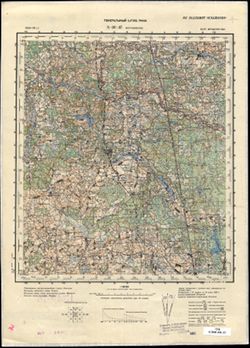
- Modern area represented: Большая Нагова (Bol’shaya Nagova), Pskovskaya oblast, Russia
- Call Number:
- GM G7000 s50 .S68 sheet O-36-109-D
- Caption:
- Не подлежит оглашению
- City:
- Касавицы (Kasavitsy)
- Copyright Holder:
- No Copyright - United States
- Country:
- СССР (USSR)
- State/Province:
- Калининская область (Kalinin oblast) and РСФСР (RSFSR)
- Physical Description:
- Scale: 1:50,000
- Persistent URL:
- http://purl.dlib.indiana.edu/iudl/images/VAC9619/VAC9619-002876
- Provenance:
- Army Map Service Library, OMAHA, Library of Congress Geography & Map Division
-
- Description:
- 1904
- Subject:
- Topical Subject: Soviet Union, Topical Subject: Maps, and Geographic Subject: Nõo
- Publisher:
- Генеральный штаб РККА
- Language:
- Russian
- Date Created:
- 1938
- Identifier:
- VAC9619-002092
- Genre:
- Military Maps and Topographic Maps
- Geographic Location:
- Coordinates: 58, 26.5, 58.3333, 27
- Related URL:
- Download GeoTIFF: https://drive.google.com/open?id=13w_DxXzkKVQn-aiFU7JrcCe8g8P-nwVL and Catalog URL: https://iucat.iu.edu/catalog/5020129
- Abstract:
- Modern area represented: Nõo, Estonia
- Call Number:
- G7000 s100 .S7 sheet O-35-66
- Caption:
- Captured map
- City:
- Ныо (Nõo)
- Copyright Holder:
- No Copyright - United States
- Country:
- Эстония (Estonia)
- Physical Description:
- Scale: 1:100,000
- Persistent URL:
- http://purl.dlib.indiana.edu/iudl/images/VAC9619/VAC9619-002092
- Provenance:
- DMA Topographic Center, Army Map Service Library, Library of Congress Geography & Map Division
-
- Subject:
- Topical Subject: Soviet Union, Topical Subject: Maps, and Geographic Subject: Kallaste
- Publisher:
- Генеральный штаб РККА
- Language:
- Russian
- Date Created:
- 1938
- Identifier:
- VAC9619-002042
- Genre:
- Topographic Maps and Military Maps
- Geographic Location:
- Coordinates: 58.3333, 27, 58.6667, 27.5
- Related URL:
- Download GeoTIFF: https://drive.google.com/open?id=1wKRfqz6_ZVnioYc7vG6ePurXBb-FRWNd and Catalog URL: https://iucat.iu.edu/catalog/5020129
- Abstract:
- Modern area represented: Kallaste, Estonia
- Call Number:
- G7000 s100 .S7 sheet O-35-55
- Caption:
- Captured map
- City:
- Калласте (Kallaste)
- Copyright Holder:
- No Copyright - United States
- Country:
- Эстония (Estonia) and СССР (USSR)
- Physical Description:
- Scale: 1:100,000
- Persistent URL:
- http://purl.dlib.indiana.edu/iudl/images/VAC9619/VAC9619-002042
- Provenance:
- DMA Topographic Center, Army Map Service Library, OMAHA, Library of Congress Geography & Map Division
-
- Subject:
- Topical Subject: Soviet Union, Topical Subject: Maps, and Geographic Subject: Puhja
- Publisher:
- Генеральный штаб РККА
- Language:
- Russian
- Date Created:
- 1938
- Identifier:
- VAC9619-002040
- Genre:
- Military Maps and Topographic Maps
- Geographic Location:
- Coordinates: 58.3333, 26, 58.6667, 26.5
- Related URL:
- Catalog URL: https://iucat.iu.edu/catalog/5020129 and Download GeoTIFF: https://drive.google.com/open?id=1i4wQuJnsHOCqehHp0MrB7X5K7EzYTMIS
- Abstract:
- Modern area represented: Puhja, Estonia
- Call Number:
- G7000 s100 .S7 sheet O-35-53
- Caption:
- Captured map
- City:
- Пухья (Puhja)
- Copyright Holder:
- No Copyright - United States
- Country:
- Эстония (Estonia)
- Physical Description:
- Scale: 1:100,000
- Persistent URL:
- http://purl.dlib.indiana.edu/iudl/images/VAC9619/VAC9619-002040
- Provenance:
- DMA Topographic Center, Army Map Service Library, Aeronautical Chart & Information Center, Library of Congress Geography & Map Division
-
- Description:
- 1895
- Subject:
- Topical Subject: Maps, Geographic Subject: Gdov, and Topical Subject: Soviet Union
- Publisher:
- Генеральный штаб РККА
- Language:
- Russian
- Date Created:
- 1938
- Identifier:
- VAC9619-002032
- Genre:
- Military Maps and Topographic Maps
- Geographic Location:
- Coordinates: 58.6667, 27.5, 59, 28
- Related URL:
- Download GeoTIFF: https://drive.google.com/open?id=1pbMaBdSJXJF6N3QsQd6dJhEfsfz7jmix and Catalog URL: https://iucat.iu.edu/catalog/5020129
- Abstract:
- Modern area represented: Гдов (Gdov), Pskovskaya oblast, Russia
- Call Number:
- G7000 s100 .S7 sheet O-35-44
- Caption:
- Captured map and Не подлежит оглашению
- City:
- Гдов (Gdov)
- Copyright Holder:
- No Copyright - United States
- Country:
- Эстония (Estonia) and СССР (USSR)
- State/Province:
- Ленинградская область (Leningrad oblast) and РСФСР (RSFSR)
- Physical Description:
- Scale: 1:100,000
- Persistent URL:
- http://purl.dlib.indiana.edu/iudl/images/VAC9619/VAC9619-002032
- Provenance:
- DMA Topographic Center, Army Map Service Library, OMAHA, Library of Congress Geography & Map Division
-
- Subject:
- Topical Subject: Soviet Union, Topical Subject: Maps, and Geographic Subject: Krasnogorodsk
- Publisher:
- Генеральный штаб РККА
- Language:
- Russian
- Date Created:
- 1938
- Identifier:
- VAC9619-003203
- Genre:
- Topographic Maps and Military Maps
- Geographic Location:
- Coordinates: 56.667, 28, 57, 28.5
- Related URL:
- Download GeoTIFF: https://drive.google.com/file/d/1QKHmdtwD2GmW7-Rba5OumGsIzSZxb6tY/view?usp=sharing and Catalog URL: https://iucat.iu.edu/catalog/5020129
- Abstract:
- Modern area represented: Красногородск (Krasnogorodsk), Pskovskaya oblast, Russia
- Call Number:
- G7000 s100 .S7 sheet O-35-117
- Caption:
- Captured map and Не подлежит оглашению
- City:
- Красный (Krasnyy)
- Copyright Holder:
- No Copyright - United States
- Country:
- СССР (USSR)
- State/Province:
- РСФСР (RSFSR), Калининская область (Kalinin oblast), and Ленинградская область (Leningrad oblast)
- Physical Description:
- Scale: 1:100,000
- Persistent URL:
- http://purl.dlib.indiana.edu/iudl/images/VAC9619/VAC9619-003203
- Provenance:
- DMA Topographic Center, Army Map Service Library, OMAHA
-
- Description:
- 1903
- Subject:
- Topical Subject: Soviet Union, Topical Subject: Maps, and Geographic Subject: Muhu
- Publisher:
- Генеральный штаб РККА
- Language:
- Russian
- Date Created:
- 1938
- Identifier:
- VAC9619-003181
- Genre:
- Military Maps and Topographic Maps
- Geographic Location:
- Coordinates: 58.333, 23, 58.667, 23.5
- Related URL:
- Download GeoTIFF: https://drive.google.com/file/d/1tzDRLaFrXESSYkYAeduJ6j6St01RYx7E/view?usp=sharing and Catalog URL: https://iucat.iu.edu/catalog/5020129
- Call Number:
- G7000 s100 .S7 sheet O-34-59
- City:
- Муху (Muhu)
- Copyright Holder:
- No Copyright - United States
- Country:
- Эстония (Estonia)
- Physical Description:
- Scale: 1:100,000
- Persistent URL:
- http://purl.dlib.indiana.edu/iudl/images/VAC9619/VAC9619-003181
- Provenance:
- DMA Topographic Center, Army Map Service Library, OMAHA, Geographic Names Branch
-
- Description:
- 1903
- Subject:
- Geographic Subject: Vilsandi, Topical Subject: Soviet Union, and Topical Subject: Maps
- Publisher:
- Генеральный штаб РККА
- Language:
- Russian
- Date Created:
- 1938
- Identifier:
- VAC9619-003178
- Genre:
- Topographic Maps and Military Maps
- Geographic Location:
- Coordinates: 58.333, 21.5, 58.667, 22
- Related URL:
- Catalog URL: https://iucat.iu.edu/catalog/5020129 and Download GeoTIFF: https://drive.google.com/file/d/1roVbd5yai7fbqSXepoOXjUrDCUvDcsPM/view?usp=sharing
- Call Number:
- G7000 s100 .S7 sheet O-34-56
- Caption:
- Captured map
- City:
- Вильсанди (Vilsandi)
- Copyright Holder:
- No Copyright - United States
- Country:
- Эстония (Estonia)
- Physical Description:
- Scale: 1:100,000
- Persistent URL:
- http://purl.dlib.indiana.edu/iudl/images/VAC9619/VAC9619-003178
- Provenance:
- DMA Topographic Center, Army Map Service Library, OMAHA
-
- Description:
- 1936
- Subject:
- Topical Subject: Soviet Union, Topical Subject: Maps, and Geographic Subject: Bogushëvsk
- Publisher:
- Генеральный штаб РККА
- Language:
- Russian
- Date Created:
- 1938
- Identifier:
- VAC9619-004176
- Genre:
- Topographic Maps and Military Maps
- Geographic Location:
- Coordinates: 54.667, 30, 55, 30.5
- Related URL:
- Catalog URL: https://iucat.iu.edu/catalog/5020129 and Download GeoTIFF: https://drive.google.com/file/d/1iS8-uU5-0W33Qvxrg_F5oj_sXo4MR9e0/view?usp=sharing
- Abstract:
- Modern area represented: Bogushëvsk, Vitebsk oblast, Belarus
- Call Number:
- G7000 s100 .S7 sheet N-36-37
- Caption:
- Не подлежит оглашению
- City:
- Богушевское (Bogushëvskoe)
- Copyright Holder:
- No Copyright - United States
- Country:
- СССР (USSR)
- State/Province:
- Витебская область (Vitebsk oblast) and Белорусская ССР (Byelorussian Soviet Socialist Republic)
- Physical Description:
- Scale: 1:100,000
- Persistent URL:
- http://purl.dlib.indiana.edu/iudl/images/VAC9619/VAC9619-004176
-
- Description:
- 1937
- Subject:
- Geographic Subject: Mezha, Topical Subject: Soviet Union, and Topical Subject: Maps
- Publisher:
- Генеральный штаб РККА
- Language:
- Russian
- Date Created:
- 1938
- Identifier:
- VAC9619-004146
- Genre:
- Topographic Maps and Military Maps
- Geographic Location:
- Coordinates: 55.667, 30, 56, 30.5
- Related URL:
- Download GeoTIFF: https://drive.google.com/file/d/1Z80Upxi8vcMagHwiWr3iAR2KODpabbk9/view?usp=sharing and Catalog URL: https://iucat.iu.edu/catalog/5020129
- Abstract:
- Modern area represented: Mezha, Russia
- Call Number:
- G7000 s100 .S7 sheet N-36-1
- Caption:
- Не подлежит оглашению
- City:
- Межа (Mezha)
- Copyright Holder:
- No Copyright - United States
- Country:
- СССР (USSR)
- State/Province:
- Белорусская ССР (Byelorussian Soviet Socialist Republic), Калининская область (Kalinin oblast), Смоленская область (Smolensk oblast), РСФСР (RSFSR), and Вите...
- Physical Description:
- Scale: 1:100,000
- Persistent URL:
- http://purl.dlib.indiana.edu/iudl/images/VAC9619/VAC9619-004146
- Provenance:
- DMA Topographic Center, Army Map Service Library, OMAHA

- « Previous
- Next »
- 1
- 2
- 3