
Search Constraints
You searched for:
Creator
Tharp, W. E. (William Edgar)
Remove constraint Creator: Tharp, W. E. (William Edgar)
Type
Image
Remove constraint Type: Image
Pages
0-99 pages
Remove constraint Pages: 0-99 pages
« Previous |
1 - 10 of 13
|
Next »
Search Results
-
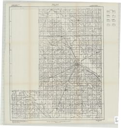
- Subject:
- Geographic Subject: Wells County (Ind.), Topical Subject: IGS Annual Reports, and Topical Subject: Soils
- Creator:
- United States. Bureau of Soils, Tharp, W. E. (William Edgar), and Wiley, W. E. (William Emmett), 1894-1967
- Publisher:
- Indiana. Department of Geology and Natural Resources
- Date Created:
- 1916
- Identifier:
- VAC3073-M-01537
- Genre:
- Thematic maps
- Geographic Location:
- Coordinates: W0852656 W0850406 N0405504 N0403400
- Related URL:
- Catalog URL: https://iucat.iu.edu/catalog/16138560
- Abstract:
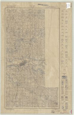
- "Field Operations, Bureau of Soils, 1915." Detached from: Soil survey of Wells County / W. E. Tharp and W. E. Wiley. In Fortieth annual report o...
- Call Number:
- G4093.W7J3 1915 .T49
- Caption:
- Imprint: [Fort Wayne]: [Fort Wayne Printing Company], [1916] and Imprint: [Indianapolis] : State of Indiana, Department of Geology, [1916]
- Physical Description:
- Dimensions: 58 x 48 cm and Scale: 1:63,360. 1 in. = 1 mile
- Alternate Identifier:
- Title Control Number: a16138560 and Alternate ID: 390726IP
- Persistent URL:
- https://purl.dlib.indiana.edu/iudl/images/VAC3073/VAC3073-M-01537
- Provenance:
- 40th Annual Report (1915) / Indiana. Department of Geology and Natural Resources.
-
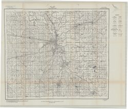
- Subject:
- Topical Subject: Soils and Geographic Subject: Grant County (Ind.)
- Creator:
- Hertenstein, Earl, Hurst, Lewis A. (Lewis Alexander), 1874-, Middleton, Philip (Soil surveyor), Watkins, W. I. (William Isaac), 1888-1973, Tharp, W. E. (Will...
- Publisher:
- Indiana. Department of Geology and Natural Resources
- Date Created:
- 1916
- Identifier:
- VAC3073-M-01510
- Genre:
- Thematic maps
- Geographic Location:
- Coordinates: W0855153 W0852639 N0403913 N0402242
- Related URL:
- Catalog URL: https://iucat.iu.edu/catalog/16142796
- Abstract:
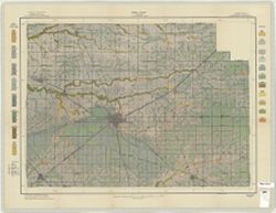
- "Field Operations Bureau of Soils, 1915"--Lower margin. Detached from: Soil survey of Grant County, Indiana / L.A. Hurst [and others]. In 40th A...
- Call Number:
- G4093.G6J3 1915 .H88
- Caption:
- Imprint: [Indianapolis] : Indiana Department of Geology, [1916] and Imprint: [Fort Wayne] : [Fort Wayne Printing Company], [1916]
- Physical Description:
- Scale: Approximately 1:63,360. 1 in. = 1 mile and Dimensions: 46 x 53 cm
- Alternate Identifier:
- Title Control Number: a16142796 and Alternate ID: 390726IP
- Persistent URL:
- https://purl.dlib.indiana.edu/iudl/images/VAC3073/VAC3073-M-01510
- Provenance:
- 40th Annual Report (1915) / Indiana. Department of Geology and Natural Resources.
-
- Subject:
- Topical Subject: IGS Annual Reports, Geographic Subject: Clinton County (Ind.), Topical Subject: Mines and mineral resources, and Topical Subject: Geology
- Creator:
- Peacock, R. H., Rose, C. M. (Soil surveyor), and Tharp, W. E. (William Edgar)
- Publisher:
- Indiana. Department of Geology and Natural Resources
- Date Created:
- 1915
- Identifier:
- VAC3073-M-01480
- Genre:
- Thematic maps
- Related URL:
- Catalog URL: https://iucat.iu.edu/catalog/4022271
- Abstract:
- From page 89 of the 39th Annual Report.
- Call Number:
- QE109 .A2 1914
- Caption:
- Imprint: Indianapolis : 1915
- Persistent URL:
- https://purl.dlib.indiana.edu/iudl/images/VAC3073/VAC3073-M-01480
- Provenance:
- 39th Annual Report (1914) / Indiana. Department of Geology and Natural Resources.
-
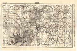
- Subject:
- Geographic Subject: Greene County (Ind.) and Topical Subject: Soils
- Creator:
- Tharp, W. E. (William Edgar)
- Publisher:
- Indiana. Department of Geology and Natural Resources
- Date Created:
- 1912
- Identifier:
- VAC3073-M-01159
- Genre:
- Thematic maps
- Geographic Location:
- Coordinates: W0871427 W0864055 N0391018 N0385408
- Related URL:
- Catalog URL: https://iucat.iu.edu/catalog/16151513
- Abstract:
- Detached from: Soil survey of Greene County (1901) / by W. E. Tharp and Charles J. Mann, of the U. S. Bureau of Soils. In Thirty-sixth annual report of Depar...
- Call Number:
- G4093.G7J3 1906 .T5
- Caption:
- Imprint: [Indianapolis] : State of Indiana, Department of Geology, [1912] [Indianapolis] : [Wm. B. Burford], [1912]
- Physical Description:
- Dimensions: 35 x 52 cm and Scale: 1:80,000
- Alternate Identifier:
- Title Control Number: a16151513 and Alternate ID: 390726IP
- Persistent URL:
- https://purl.dlib.indiana.edu/iudl/images/VAC3073/VAC3073-M-01159
- Provenance:
- 36th Annual Report (1911) / Indiana. Department of Geology and Natural Resources.
-
- Subject:
- Geographic Subject: Miami County (Ind.), Topical Subject: Classification, and Topical Subject: Soils
- Creator:
- Tharp, W. E. (William Edgar)
- Publisher:
- United States. Bureau of Soils
- Date Created:
- 1927
- Identifier:
- VAC3073-M-00967
- Genre:
- Thematic maps
- Geographic Location:
- Coordinates: W0861000 W0855200 N0410000 N0402200
- Related URL:
- Catalog URL: https://iucat.iu.edu/catalog/2872802
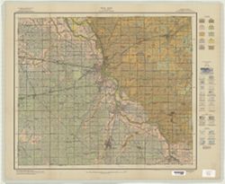
- Abstract:
- Shows soil types classification by colors and symbols. "Field Operations, Bureau of Chemistry and Soils, 1927." "Litho Eastern Offset In...
- Call Number:
- G4093 .M6J3 1927 .T493
- Caption:
- Imprint: [Washington, D.C.?] : The Bureau, 1927.
- Physical Description:
- Scale: 1:63,360 and Dimensions: 78 x 43 cm
- Alternate Identifier:
- Title Control Number: CAY7757BB
- Persistent URL:
- https://purl.dlib.indiana.edu/iudl/images/VAC3073/VAC3073-M-00967
-
- Subject:
- Topical Subject: Classification, Topical Subject: Soils, and Geographic Subject: Clinton County (Ind.)
- Creator:
- Tharp, W. E. (William Edgar)
- Publisher:
- United States. Bureau of Soils
- Date Created:
- 1914
- Identifier:
- VAC3073-M-00943
- Genre:
- Thematic maps
- Geographic Location:
- Coordinates: W0864200 W0861500 N0402600 N0401100
- Related URL:
- Catalog URL: https://iucat.iu.edu/catalog/2864813
- Abstract:
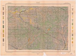
- Shows soil types classification by colors and symbols. "A. Hoen & Co. Lith. Baltimore, Md." "Field operations Bureau of Soils 1914."
- Call Number:
- G4093 .C6J3 1914 .T493
- Caption:
- Imprint: [Washington, D.C.] : The Bureau, 1914
- Physical Description:
- Dimensions: 46 x 62 cm and Scale: 1:63,360
- Alternate Identifier:
- Title Control Number: CAX0562BB
- Persistent URL:
- https://purl.dlib.indiana.edu/iudl/images/VAC3073/VAC3073-M-00943
-
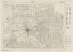
- Subject:
- Geographic Subject: Grant County (Ind.) and Topical Subject: Soils
- Creator:
- Hurst, Lewis A. (Lewis Alexander), 1874-, Middleton, Philip (Soil surveyor), Hertenstein, Earl, Indiana. Department of Geology and Natural Resources, Tharp, ...
- Publisher:
- United States. Bureau of Soils
- Date Created:
- 1915
- Identifier:
- VAC3073-M-00933
- Genre:
- Thematic maps
- Geographic Location:
- Coordinates: W0855200 W0852700 N0403900 N0402300
- Related URL:
- Catalog URL: https://iucat.iu.edu/catalog/16142796
- Abstract:
- U.S. Dept. of Agriculture, Bureau of Soils [and] State of Indiana, Department of Geology , soils surveyed by Lewis A. Hurst, W.I. Watkins, and W.E. Tharp, of...
- Call Number:
- G4093 .G6J3 1915 .H87
- Caption:
- Imprint: [Washington, D.C.?] : Bureau of Soils, [1915]
- Physical Description:
- Scale: 1:63,360. 1 inch = 1 mile and Dimensions: 48 x 57 cm
- Alternate Identifier:
- Title Control Number: a16142796 and Alternate ID: CAY2874BB
- Persistent URL:
- https://purl.dlib.indiana.edu/iudl/images/VAC3073/VAC3073-M-00933
-
- Subject:
- Geographic Subject: Boone County (Ind.), Topical Subject: Soils, and Topical Subject: Classification
- Creator:
- Tharp, W. E. (William Edgar)
- Publisher:
- United States. Bureau of Soils
- Date Created:
- 1912
- Identifier:
- VAC3073-M-00766
- Genre:
- Thematic maps
- Geographic Location:
- Coordinates: W0864200 W0861500 N0401100 N0395600
- Related URL:
- Catalog URL: https://iucat.iu.edu/catalog/2864229
- Abstract:
- Shows soil types classification by colors and symbols. "Field Operations Bureau of Soils 1912." "A. Hoen & Co. Lith. Baltimore, Md."
- Call Number:
- G4093 .B6J3 1912 .T493
- Caption:
- Imprint: [Washington, D.C.?] : The Bureau, [1912?]
- Physical Description:
- Scale: 1:63,360 and Dimensions: 47 x 63 cm
- Alternate Identifier:
- Title Control Number: CAW9301BB
- Persistent URL:
- https://purl.dlib.indiana.edu/iudl/images/VAC3073/VAC3073-M-00766
-
- Subject:
- Topical Subject: Classification, Topical Subject: Soils, and Geographic Subject: Hendricks County (Ind.)
- Creator:
- Tharp, W. E. (William Edgar)
- Publisher:
- United States. Bureau of Soils
- Date Created:
- 1913
- Identifier:
- VAC3073-M-00732
- Genre:
- Thematic maps
- Geographic Location:
- Coordinates: W0864200 W0862000 N0395600 N0393600
- Related URL:
- Catalog URL: https://iucat.iu.edu/catalog/2871096
- Abstract:
- Shows soil types classification by colors and symbols. "Field Operations, Bureau of Soils, 1913." "A. Hoen & Co. Lith Baltimore Md."
- Call Number:
- G4093 .H5J3 1913 .T487
- Caption:
- Imprint: [Washington, D.C.?] : Bureau of Soils, 1913.
- Physical Description:
- Scale: 1:63,360 and Dimensions: 57 x 50 cm
- Alternate Identifier:
- Title Control Number: CAY4125BB
- Persistent URL:
- https://purl.dlib.indiana.edu/iudl/images/VAC3073/VAC3073-M-00732
-
- Subject:
- Geographic Subject: Greene County (Ind.), Topical Subject: Classification, and Topical Subject: Soils
- Creator:
- Tharp, W. E. (William Edgar)
- Publisher:
- United States. Bureau of Soils
- Date Created:
- 1906
- Identifier:
- VAC3073-M-00708
- Genre:
- Thematic maps
- Geographic Location:
- Coordinates: W0871427 W0864055 N0391018 N0385408
- Related URL:
- Catalog URL: https://iucat.iu.edu/catalog/2870411
- Abstract:
- Shows soil types by colors and symbols.
- Call Number:
- G4093 .G7J3 1906 .T4
- Caption:
- Imprint: [Washington, D.C.?] : The Bureau, [1906?]
- Physical Description:
- Scale: 1:63,360 and Dimensions: 49 x 77 cm
- Alternate Identifier:
- Title Control Number: CAY3035BB
- Persistent URL:
- https://purl.dlib.indiana.edu/iudl/images/VAC3073/VAC3073-M-00708
