
Search Constraints
You searched for:
Pages
0-99 pages
Remove constraint Pages: 0-99 pages
Provenance
M. I. Map Library
Remove constraint Provenance: M. I. Map Library
« Previous |
1 - 20 of 179
|
Next »
Search Results
-

- Subject:
- Geographic Subject: Juodkrantė, Topical Subject: Maps, and Topical Subject: Soviet Union
- Publisher:
- Генеральный штаб Красной Армии
- Language:
- Russian
- Date Created:
- 1940
- Identifier:
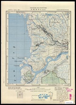
- VAC9619-003576
- Genre:
- Topographic Maps and Military Maps
- Geographic Location:
- Coordinates: 55.5, 21, 55.583, 21.125
- Related URL:
- Download GeoTIFF: https://drive.google.com/file/d/1cpl0xjbpMukwN0OEFIfjfUMfjJhidcFq/view?usp=sharing and Catalog URL: https://iucat.iu.edu/catalog/14701157
- Abstract:
- Modern area represented: Juodkrantė, Lithuania
- Call Number:
- G7063.K2 s25 .S6 sheet N-34-19-A-c
- City:
- Шварцорт (Shvartsort/Schwarzort)
- Copyright Holder:
- No Copyright - United States
- Country:
- Германия (Восточная Пруссия) (Germany (East Prussia))
- Physical Description:
- Scale: 1:25,000
- Persistent URL:
- http://purl.dlib.indiana.edu/iudl/images/VAC9619/VAC9619-003576
- Provenance:
- M. I. Map Library
-
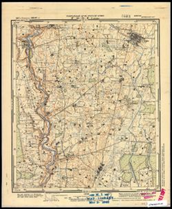
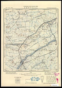
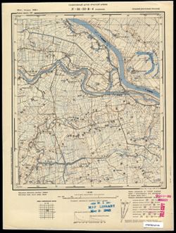
- Subject:
- Geographic Subject: Krakės, Topical Subject: Soviet Union, and Topical Subject: Maps
- Publisher:
- Генеральный штаб Красной Армии
- Language:
- Russian
- Date Created:
- 1941
- Identifier:
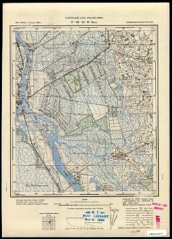
- VAC9619-003583
- Genre:
- Topographic Maps and Military Maps
- Geographic Location:
- Coordinates: 55.333, 23.625, 55.417, 23.75
- Related URL:
- Download GeoTIFF: https://drive.google.com/file/d/19Cr2qI4RqBkehkyBa1nvsuagjpFFQlbF/view?usp=sharing and Catalog URL: https://iucat.iu.edu/catalog/14701157
- Abstract:
- Modern area represented: Krakės, Lithuania
- Call Number:
- G7063.K2 s25 .S6 sheet N-34-24-C-d
- Caption:
- Секретно
- City:
- Кроки (Kroki)
- Copyright Holder:
- No Copyright - United States
- Country:
- СССР (USSR)
- State/Province:
- Литовская ССР (Lithuanian Soviet Socialist Republic)
- Physical Description:
- Scale: 1:25,000
- Persistent URL:
- http://purl.dlib.indiana.edu/iudl/images/VAC9619/VAC9619-003583
- Provenance:
- M. I. Map Library
-
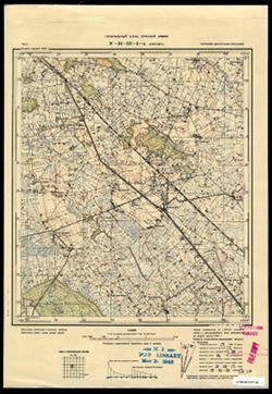
- Subject:
- Topical Subject: Maps, Geographic Subject: Pamidžio Kopa, and Topical Subject: Soviet Union
- Publisher:
- Генеральный штаб Красной Армии
- Language:
- Russian
- Date Created:
- 1940
- Identifier:
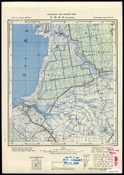
- VAC9619-003584
- Genre:
- Topographic Maps and Military Maps
- Geographic Location:
- Coordinates: 55.25, 20.875, 55.333, 21
- Related URL:
- Catalog URL: https://iucat.iu.edu/catalog/14701157 and Download GeoTIFF: https://drive.google.com/file/d/1m1V0SGipIy0sho-kOLoS7Kg7F_lr0UDu/view?usp=sharing
- Abstract:
- Modern area represented: Pamidžio Kopa, Lithuania
- Call Number:
- G7063.K2 s25 .S6 sheet N-34-30-B-b
- City:
- Парниденер-Берг (Parnidener-Berg)
- Copyright Holder:
- No Copyright - United States
- Country:
- Германия (Восточная Пруссия) (Germany (East Prussia))
- Physical Description:
- Scale: 1:25,000
- Persistent URL:
- http://purl.dlib.indiana.edu/iudl/images/VAC9619/VAC9619-003584
- Provenance:
- M. I. Map Library
-
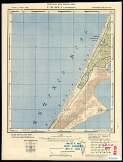
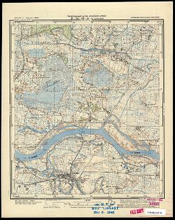
- Description:
- 1910
- Subject:
- Topical Subject: Soviet Union, Topical Subject: Maps, and Geographic Subject: Nida
- Publisher:
- Генеральный штаб Красной Армии
- Language:
- Russian
- Date Created:
- 1940
- Identifier:
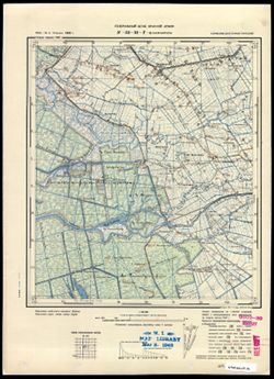
- VAC9619-003591
- Genre:
- Topographic Maps and Military Maps
- Geographic Location:
- Coordinates: 55.25, 21, 55.333, 21.125
- Related URL:
- Catalog URL: https://iucat.iu.edu/catalog/14701157 and Download GeoTIFF: https://drive.google.com/file/d/1N5effyxaL1laqoIKkl4KqUYUAqu8zFP5/view?usp=sharing
- Abstract:
- Modern area represented: Nida, Lithuania
- Call Number:
- G7063.K2 s25 .S6 sheet N-34-31-A-a
- City:
- Нидден (Nidden)
- Copyright Holder:
- No Copyright - United States
- Country:
- Германия (Восточная Пруссия) (Germany (East Prussia))
- Physical Description:
- Scale: 1:25,000
- Persistent URL:
- http://purl.dlib.indiana.edu/iudl/images/VAC9619/VAC9619-003591
- Provenance:
- M. I. Map Library
-
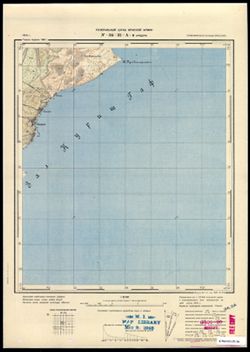
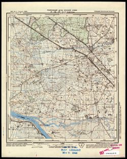
- Description:
- 1911
- Subject:
- Topical Subject: Maps, Topical Subject: Soviet Union, and Geographic Subject: Zaliv Kamyshevyy
- Publisher:
- Генеральный штаб Красной Армии
- Language:
- Russian
- Date Created:
- 1940
- Identifier:
- VAC9619-003592
- Genre:
- Topographic Maps and Military Maps
- Geographic Location:
- Coordinates: 55.167, 21.125, 55.25, 21.25
- Related URL:
- Download GeoTIFF: https://drive.google.com/file/d/1USuVWHSq1lIB27tE-c2qFifs6AeAOsHG/view?usp=sharing and Catalog URL: https://iucat.iu.edu/catalog/14701157
- Abstract:
- Modern area represented: Залив Камышевый (Zaliv Kamyshevyy_, Kaliningraskaya oblast, Russia
- Call Number:
- G7063.K2 s25 .S6 sheet N-34-31-A-d
- City:
- Залив Гаурин (Gaurine)
- Copyright Holder:
- No Copyright - United States
- Country:
- Германия (Восточная Пруссия) (Germany (East Prussia))
- Physical Description:
- Scale: 1:25,000
- Persistent URL:
- http://purl.dlib.indiana.edu/iudl/images/VAC9619/VAC9619-003592
- Provenance:
- M. I. Map Library
-
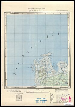
- Subject:
- Topical Subject: Soviet Union, Geographic Subject: Pakalnė, and Topical Subject: Maps
- Publisher:
- Генеральный штаб Красной Армии
- Language:
- Russian
- Date Created:
- 1940
- Identifier:
- VAC9619-003593
- Genre:
- Military Maps and Topographic Maps
- Geographic Location:
- Coordinates: 55.25, 21.25, 55.333, 21.375
- Related URL:
- Catalog URL: https://iucat.iu.edu/catalog/14701157 and Download GeoTIFF: https://drive.google.com/file/d/1frCC6yNDE5XBgN-qoYkrHDNUdIGiIp4Q/view?usp=sharing
- Abstract:
- Modern area represented: Pakalnė, Lithuania
- Call Number:
- G7063.K2 s25 .S6 sheet N-34-31-B-a
- City:
- Покаллна (Pokallna)
- Copyright Holder:
- No Copyright - United States
- Country:
- Германия (Восточная Пруссия) (Germany (East Prussia))
- Physical Description:
- Scale: 1:25,000
- Persistent URL:
- http://purl.dlib.indiana.edu/iudl/images/VAC9619/VAC9619-003593
- Provenance:
- M. I. Map Library
-
- Subject:
- Topical Subject: Maps, Topical Subject: Soviet Union, and Geographic Subject: Rusnė
- Publisher:
- Генеральный штаб Красной Армии
- Language:
- Russian
- Date Created:
- 1940
- Identifier:
- VAC9619-003594
- Genre:
- Military Maps and Topographic Maps
- Geographic Location:
- Coordinates: 55.25, 21.375, 55.333, 21.5
- Related URL:
- Catalog URL: https://iucat.iu.edu/catalog/14701157 and Download GeoTIFF: https://drive.google.com/file/d/1BGNTZ7bt691Ez1fNfdmM-B8Ajhd9kJCT/view?usp=sharing
- Abstract:
- Modern area represented: Rusnė, Lithuania
- Call Number:
- G7063.K2 s25 .S6 sheet N-34-31-B-b
- City:
- Рус (Rus)
- Copyright Holder:
- No Copyright - United States
- Country:
- Германия (Восточная Пруссия) (Germany (East Prussia))
- Physical Description:
- Scale: 1:25,000
- Persistent URL:
- http://purl.dlib.indiana.edu/iudl/images/VAC9619/VAC9619-003594
- Provenance:
- M. I. Map Library
-
- Subject:
- Topical Subject: Maps, Geographic Subject: Mysovka, and Topical Subject: Soviet Union
- Publisher:
- Генеральный штаб Красной Армии
- Language:
- Russian
- Date Created:
- 1940
- Identifier:
- VAC9619-003595
- Genre:
- Topographic Maps and Military Maps
- Geographic Location:
- Coordinates: 55.167, 21.25, 55.25, 21.375
- Related URL:
- Download GeoTIFF: https://drive.google.com/file/d/12kNkyzXuaSJCz6EOs69IWPDw8i3_j1VC/view?usp=sharing and Catalog URL: https://iucat.iu.edu/catalog/14701157
- Abstract:
- Modern area represented: Мысовка (Mysovka), Kaliningradskaya oblast, Russia
- Call Number:
- G7063.K2 s25 .S6 sheet N-34-31-B-c
- City:
- Каркельн (Karkel’n)
- Copyright Holder:
- No Copyright - United States
- Country:
- Германия (Восточная Пруссия) (Germany (East Prussia))
- Physical Description:
- Scale: 1:25,000
- Persistent URL:
- http://purl.dlib.indiana.edu/iudl/images/VAC9619/VAC9619-003595
- Provenance:
- M. I. Map Library
-
- Subject:
- Topical Subject: Soviet Union, Geographic Subject: Prokhladnoye, and Topical Subject: Maps
- Publisher:
- Генеральный штаб Красной Армии
- Language:
- Russian
- Date Created:
- 1940
- Identifier:
- VAC9619-003599
- Genre:
- Topographic Maps and Military Maps
- Geographic Location:
- Coordinates: 55.083, 21.25, 55.167, 21.375
- Related URL:
- Catalog URL: https://iucat.iu.edu/catalog/14701157 and Download GeoTIFF: https://drive.google.com/file/d/1YKY74-2xF2oLvrxWPb4HoNkvYfD7rrvV/view?usp=sharing
- Abstract:
- Modern area represented: Прохладное (Prokhladnoye), Kaliningradskaya oblast, Russia
- Call Number:
- G7063.K2 s25 .S6 sheet N-34-31-D-a
- City:
- Каллнингкен (Kallningken)
- Copyright Holder:
- No Copyright - United States
- Country:
- Германия (Восточная Пруссия) (Germany (East Prussia))
- Physical Description:
- Scale: 1:25,000
- Persistent URL:
- http://purl.dlib.indiana.edu/iudl/images/VAC9619/VAC9619-003599
- Provenance:
- M. I. Map Library
-
- Subject:
- Topical Subject: Soviet Union, Geographic Subject: Bol’shiye Berezhki, and Topical Subject: Maps
- Publisher:
- Генеральный штаб Красной Армии
- Language:
- Russian
- Date Created:
- 1940
- Identifier:
- VAC9619-003600
- Genre:
- Topographic Maps and Military Maps
- Geographic Location:
- Coordinates: 55.083, 21.375, 55.167, 21.5
- Related URL:
- Download GeoTIFF: https://drive.google.com/file/d/1Xs43niWnmymd55tnrGzKRKBIheFHIdqO/view?usp=sharing and Catalog URL: https://iucat.iu.edu/catalog/14701157
- Abstract:
- Modern area represented: Большие Бережки (Bol’shiye Berezhki), Kaliningradskaya oblast, Russia
- Call Number:
- G7063.K2 s25 .S6 sheet N-34-31-D-b
- City:
- Альт Лаппинен (Al’t Lappinen)
- Copyright Holder:
- No Copyright - United States
- Country:
- Германия (Восточная Пруссия) (Germany (East Prussia))
- Physical Description:
- Scale: 1:25,000
- Persistent URL:
- http://purl.dlib.indiana.edu/iudl/images/VAC9619/VAC9619-003600
- Provenance:
- M. I. Map Library
-
- Description:
- 1912
- Subject:
- Topical Subject: Maps, Topical Subject: Soviet Union, and Geographic Subject: Juknaičiai
- Publisher:
- Генеральный штаб Красной Армии
- Language:
- Russian
- Date Created:
- 1940
- Identifier:
- VAC9619-003602
- Genre:
- Topographic Maps and Military Maps
- Geographic Location:
- Coordinates: 55.25, 21.5, 55.333, 21.625
- Related URL:
- Catalog URL: https://iucat.iu.edu/catalog/14701157 and Download GeoTIFF: https://drive.google.com/file/d/1ihu5UIGhlU3arCwjYStCbKR3_9DdTMje/view?usp=sharing
- Abstract:
- Modern area represented: part of Juknaičiai (?), Lithuania
- Call Number:
- G7063.K2 s25 .S6 sheet N-34-32-A-a
- City:
- Бляузден (Blyauzden)
- Copyright Holder:
- No Copyright - United States
- Country:
- Германия (Восточная Пруссия) (Germany (East Prussia))
- Physical Description:
- Scale: 1:25,000
- Persistent URL:
- http://purl.dlib.indiana.edu/iudl/images/VAC9619/VAC9619-003602
- Provenance:
- M. I. Map Library
-
- Subject:
- Topical Subject: Maps, Topical Subject: Soviet Union, and Geographic Subject: Yasnoye
- Publisher:
- Генеральный штаб Красной Армии
- Language:
- Russian
- Date Created:
- 1941
- Identifier:
- VAC9619-003603
- Genre:
- Topographic Maps and Military Maps
- Geographic Location:
- Coordinates: 55.167, 21.5, 55.25, 21.625
- Related URL:
- Download GeoTIFF: https://drive.google.com/file/d/1mN5NdriMOpVPw3f77-YKlWI7E37I_SUW/view?usp=sharing and Catalog URL: https://iucat.iu.edu/catalog/14701157
- Abstract:
- Modern area represented: Ясное (Yasnoye), Kaliningradskaya oblast, Russia
- Call Number:
- G7063.K2 s25 .S6 sheet N-34-32-A-c
- City:
- Каукемен (Kaukemen)
- Copyright Holder:
- No Copyright - United States
- Country:
- Германия (Восточная Пруссия) (Germany (East Prussia))
- Physical Description:
- Scale: 1:25,000
- Persistent URL:
- http://purl.dlib.indiana.edu/iudl/images/VAC9619/VAC9619-003603
- Provenance:
- M. I. Map Library
-
- Subject:
- Topical Subject: Maps, Geographic Subject: Usėnai, and Topical Subject: Soviet Union
- Publisher:
- Генеральный штаб Красной Армии
- Language:
- Russian
- Date Created:
- 1941
- Identifier:
- VAC9619-003604
- Genre:
- Military Maps and Topographic Maps
- Geographic Location:
- Coordinates: 55.167, 21.625, 55.25, 21.75
- Related URL:
- Download GeoTIFF: https://drive.google.com/file/d/1ILW9UdHMeTHllNX08KgFPtp4sluLbiD6/view?usp=sharing and Catalog URL: https://iucat.iu.edu/catalog/14701157
- Abstract:
- Modern area represented: Usėnai, Lithuania
- Call Number:
- G7063.K2 s25 .S6 sheet N-34-32-A-d
- City:
- Мэдевальд (Mädewald)
- Copyright Holder:
- No Copyright - United States
- Country:
- Германия (Восточная Пруссия) (Germany (East Prussia))
- Physical Description:
- Scale: 1:25,000
- Persistent URL:
- http://purl.dlib.indiana.edu/iudl/images/VAC9619/VAC9619-003604
- Provenance:
- M. I. Map Library
-
- Description:
- 1914
- Subject:
- Geographic Subject: Leninskoye, Topical Subject: Soviet Union, and Topical Subject: Maps
- Publisher:
- Генеральный штаб Красной Армии
- Language:
- Russian
- Date Created:
- 1940
- Identifier:
- VAC9619-003607
- Genre:
- Military Maps and Topographic Maps
- Geographic Location:
- Coordinates: 55.083, 21.625, 55.167, 21.75
- Related URL:
- Catalog URL: https://iucat.iu.edu/catalog/14701157 and Download GeoTIFF: https://drive.google.com/file/d/1j51PFng0UaZNVB4RJ-jG-m1SVLImG4T8/view?usp=sharing
- Abstract:
- Modern area represented: Ленинское (Leninskoye), Kaliningradskaya oblast, Russia
- Call Number:
- G7063.K2 s25 .S6 sheet N-34-32-C-b
- City:
- Покранен (Pokranen)
- Copyright Holder:
- No Copyright - United States
- Country:
- Германия (Восточная Пруссия) (Germany (East Prussia))
- Physical Description:
- Scale: 1:25,000
- Persistent URL:
- http://purl.dlib.indiana.edu/iudl/images/VAC9619/VAC9619-003607
- Provenance:
- M. I. Map Library
-
- Subject:
- Geographic Subject: Gastellovo, Topical Subject: Maps, and Topical Subject: Soviet Union
- Publisher:
- Генеральный штаб Красной Армии
- Language:
- Russian
- Date Created:
- 1940
- Identifier:
- VAC9619-003608
- Genre:
- Military Maps and Topographic Maps
- Geographic Location:
- Coordinates: 55, 21.5, 55.083, 21.625
- Related URL:
- Download GeoTIFF: https://drive.google.com/file/d/1MZqo3Hsc5RDE9S6gTO-v8LULaYz-h7eG/view?usp=sharing and Catalog URL: https://iucat.iu.edu/catalog/14701157
- Abstract:
- Modern area represented: Гастеллово (Gastellovo), Kaliningradskaya oblast, Russia
- Call Number:
- G7063.K2 s25 .S6 sheet N-34-32-C-c
- City:
- Гросс Фридрихсдорф (Gross-Friedrichsdorf)
- Copyright Holder:
- No Copyright - United States
- Country:
- Германия (Восточная Пруссия) (Germany (East Prussia))
- Physical Description:
- Scale: 1:25,000
- Persistent URL:
- http://purl.dlib.indiana.edu/iudl/images/VAC9619/VAC9619-003608
- Provenance:
- M. I. Map Library
-
- Subject:
- Topical Subject: Soviet Union, Topical Subject: Maps, and Geographic Subject: Stoniškiai
- Publisher:
- Генеральный штаб Красной Армии
- Language:
- Russian
- Date Created:
- 1940
- Identifier:
- VAC9619-003605
- Genre:
- Military Maps and Topographic Maps
- Geographic Location:
- Coordinates: 55.167, 21.75, 55.25, 21.875
- Related URL:
- Catalog URL: https://iucat.iu.edu/catalog/14701157 and Download GeoTIFF: https://drive.google.com/file/d/18tsNi3lGYr3QkOTeUG0haO250w1AnaYA/view?usp=sharing
- Abstract:
- Modern area represented: Stoniškiai, Lithuania
- Call Number:
- G7063.K2 s25 .S6 sheet N-34-32-B-c
- City:
- Штонишкен (Stonischken)
- Copyright Holder:
- No Copyright - United States
- Country:
- Германия (Восточная Пруссия) (Germany (East Prussia))
- Physical Description:
- Scale: 1:25,000
- Persistent URL:
- http://purl.dlib.indiana.edu/iudl/images/VAC9619/VAC9619-003605
- Provenance:
- M. I. Map Library
-
- Subject:
- Topical Subject: Soviet Union and Topical Subject: Maps
- Publisher:
- Генеральный штаб Красной Армии
- Language:
- Russian
- Date Created:
- 1941
- Identifier:
- VAC9619-003610
- Genre:
- Topographic Maps and Military Maps
- Geographic Location:
- Coordinates: 55.083, 21.75, 55.167, 21.875
- Related URL:
- Catalog URL: https://iucat.iu.edu/catalog/14701157 and Download GeoTIFF: https://drive.google.com/file/d/1R9_sJzyUDMnr8lrmdZvvsQeJpRJJRUid/view?usp=sharing
- Abstract:
- Modern area represented: part of Советск (Sovetsk) (?), Kaliningradskaya oblast, Russia
- Call Number:
- G7063.K2 s25 .S6 sheet N-34-32-D-a
- City:
- Штолбек
- Copyright Holder:
- No Copyright - United States
- Country:
- Германия (Восточная Пруссия) (Germany (East Prussia))
- Physical Description:
- Scale: 1:25,000
- Persistent URL:
- http://purl.dlib.indiana.edu/iudl/images/VAC9619/VAC9619-003610
- Provenance:
- M. I. Map Library
-
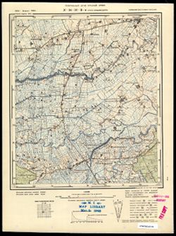
- Subject:
- Topical Subject: Soviet Union, Geographic Subject: Lygainiai, and Topical Subject: Maps
- Publisher:
- Генеральный штаб Красной Армии
- Language:
- Russian
- Date Created:
- 1941
- Identifier:
- VAC9619-003631
- Genre:
- Military Maps and Topographic Maps
- Geographic Location:
- Coordinates: 55, 23.625, 55.083, 23.75
- Related URL:
- Download GeoTIFF: https://drive.google.com/file/d/1S2wLZFzyMw9G1AZTYyk76tctZv36Q1Ml/view?usp=sharing and Catalog URL: https://iucat.iu.edu/catalog/14701157
- Abstract:
- Modern area represented: Lygainiai, Lithuania
- Call Number:
- G7063.K2 s25 .S6 sheet N-34-36-C-d
- Caption:
- Секретно
- City:
- Лигайне (Ligayne)
- Copyright Holder:
- No Copyright - United States
- Country:
- СССР (USSR)
- State/Province:
- Литовская ССР (Lithuanian Soviet Socialist Republic)
- Physical Description:
- Scale: 1:25,000
- Persistent URL:
- http://purl.dlib.indiana.edu/iudl/images/VAC9619/VAC9619-003631
- Provenance:
- M. I. Map Library
-
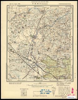
- Subject:
- Topical Subject: Maps, Topical Subject: Soviet Union, and Geographic Subject: Muniškiai
- Publisher:
- Генеральный штаб Красной Армии
- Language:
- Russian
- Date Created:
- 1941
- Identifier:
- VAC9619-003634
- Genre:
- Military Maps and Topographic Maps
- Geographic Location:
- Coordinates: 55, 23.75, 55.083, 23.875
- Related URL:
- Download GeoTIFF: https://drive.google.com/file/d/1RSHjF8sA7nONXJFs4vMmAN6eP3uezOJd/view?usp=sharing and Catalog URL: https://iucat.iu.edu/catalog/14701157
- Abstract:
- Modern area represented: Muniškiai, Lithuania
- Call Number:
- G7063.K2 s25 .S6 sheet N-34-36-D-c
- Caption:
- Секретно
- City:
- Мунишканцы (Munishkantsy)
- Copyright Holder:
- No Copyright - United States
- Country:
- СССР (USSR)
- State/Province:
- Литовская ССР (Lithuanian Soviet Socialist Republic)
- Physical Description:
- Scale: 1:25,000
- Persistent URL:
- http://purl.dlib.indiana.edu/iudl/images/VAC9619/VAC9619-003634
- Provenance:
- M. I. Map Library
-
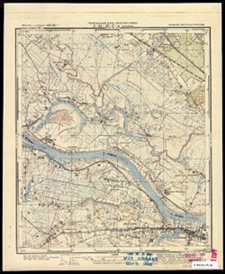
- Subject:
- Topical Subject: Soviet Union, Topical Subject: Maps, and Geographic Subject: Didieji Ibėnai
- Publisher:
- Генеральный штаб Красной Армии
- Language:
- Russian
- Date Created:
- 1941
- Identifier:
- VAC9619-003635
- Genre:
- Military Maps and Topographic Maps
- Geographic Location:
- Coordinates: 55, 23.875, 55.083, 24
- Related URL:
- Catalog URL: https://iucat.iu.edu/catalog/14701157 and Download GeoTIFF: https://drive.google.com/file/d/1tupUHbpChdC5mnOsJmV22NSUxvuLLwGp/view?usp=sharing
- Abstract:
- Modern area represented: Didieji Ibėnai, Lithuania
- Call Number:
- G7063.K2 s25 .S6 sheet N-34-36-D-d
- Caption:
- Секретно
- City:
- Никольская (Nikol’skaya)
- Copyright Holder:
- No Copyright - United States
- Country:
- СССР (USSR)
- State/Province:
- Литовская ССР (Lithuanian Soviet Socialist Republic)
- Physical Description:
- Scale: 1:25,000
- Persistent URL:
- http://purl.dlib.indiana.edu/iudl/images/VAC9619/VAC9619-003635
- Provenance:
- M. I. Map Library
