Topical Subject: Sewerage and Geographic Subject: Jeffersonville (Ind.)
Creator:
Bruner, J. W.
Publisher:
Board of Public Works & Safety
Date Created:
1946
Identifier:
VAC3073-M-00873
Genre:
Thematic maps
Geographic Location:
Coordinates: W0854556 W0854143 N0381820 N0381537
Related URL:
Catalog URL: https://iucat.iu.edu/catalog/5382860
Abstract:
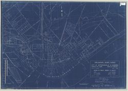
Shows 1884 and 1937 high water lines and floodwall. Blueprint. Includes diagram of Louisville and Portland Canal gages showing high water on various ...
Call Number:
G4094.J4 N46 1946 .B78
Caption:
Imprint: [Jeffersonville, Ind.?] : Board of Public Works & Safety, [1946]