
Search Constraints
You searched for:
Date Created
1941
Remove constraint Date Created: 1941
Provenance
DMA Topographic Center, Army Map Service Library, Library of Congress Geography & Map Division
Remove constraint Provenance: DMA Topographic Center, Army Map Service Library, Library of Congress Geography & Map Division
Search Results
-
- Description:
- 1938
- Subject:
- Topical Subject: Maps, Geographic Subject: Denkovo, and Topical Subject: Soviet Union
- Publisher:
- Главное управление геодезии и картографии при СНК СССР
- Language:
- Russian
- Date Created:
- 1941
- Identifier:
- VAC9619-003516
- Genre:
- Topographic Maps and Military Maps
- Geographic Location:
- Coordinates: 56, 36.25, 56.167, 36.5
- Related URL:
- Catalog URL: http://iucat.iu.edu/catalog/5020131 and Download GeoTIFF: https://drive.google.com/file/d/15_6DpZjY9YjpGrhF-Le1L8fdxmap_zTB/view?usp=sharing
- Abstract:
- Modern area represented: Denkovo, Russia
- Call Number:
- GM G7000 s50 .S68 sheet O-37-133-D
- City:
- Деньково (Denkovo)
- Copyright Holder:
- No Copyright - United States
- Country:
- СССР (USSR)
- State/Province:
- Волоколамский район (Volokolamsky district), Клинский район (Klinsky district), Ново-Петровский (Novopetrovsky district), and Московская область (Moscow oblast)
- Physical Description:
- Scale: 1:50,000
- Persistent URL:
- http://purl.dlib.indiana.edu/iudl/images/VAC9619/VAC9619-003516
- Provenance:
- DMA Topographic Center, Army Map Service Library, Library of Congress Geography & Map Division
-
- Subject:
- Geographic Subject: Teryayevo, Topical Subject: Soviet Union, and Topical Subject: Maps
- Publisher:
- Главное управление геодезии и картографии при СНК СССР
- Language:
- Russian
- Date Created:
- 1941
- Identifier:
- VAC9619-003515
- Genre:
- Topographic Maps and Military Maps
- Geographic Location:
- Coordinates: 56.167, 36, 56.333, 36.25
- Related URL:
- Download GeoTIFF: https://drive.google.com/file/d/10M8uz-wV7Uejy6zTPeWDdLEvJ1CG2-O-/view?usp=sharing and Catalog URL: http://iucat.iu.edu/catalog/5020131
- Abstract:
- Modern area represented: Теряево (Teryayevo), Moscow oblast, Russia
- Call Number:
- GM G7000 s50 .S68 sheet O-37-133-A
- City:
- Теряева Слобода (Teryayeva Sloboda)
- Copyright Holder:
- No Copyright - United States
- Country:
- СССР (USSR)
- State/Province:
- Волоколамский район (Volokolamsky district), Клинский район (Klinsky district), Московская область (Moscow oblast), and Лотошинский район (Lotoshinsky district)
- Physical Description:
- Scale: 1:50,000
- Persistent URL:
- http://purl.dlib.indiana.edu/iudl/images/VAC9619/VAC9619-003515
- Provenance:
- DMA Topographic Center, Army Map Service Library, Library of Congress Geography & Map Division
-
- Description:
- 1938
- Subject:
- Topical Subject: Maps, Geographic Subject: Khlystovo, and Topical Subject: Soviet Union
- Publisher:
- Главное управление геодезии и картографии при СНК СССР
- Language:
- Russian
- Date Created:
- 1941
- Identifier:
- VAC9619-003507
- Genre:
- Topographic Maps and Military Maps
- Geographic Location:
- Coordinates: 56, 33.75, 56.167, 34
- Related URL:
- Download GeoTIFF: https://drive.google.com/file/d/1fGG2lobcB7qv87HgHV3b9IjcaiO1TFwo/view?usp=sharing and Catalog URL: http://iucat.iu.edu/catalog/5020131
- Abstract:
- Modern area represented: Хлыстово (Khlystovo), Tverskaya oblast, Russia
- Call Number:
- GM G7000 s50 .S68 sheet O-36-140-D
- Caption:
- Captured map
- City:
- Хлыстово (Khlystovo)
- Copyright Holder:
- No Copyright - United States
- Country:
- СССР (USSR)
- State/Province:
- Оленинский район (Oleninsky district), Смоленская область (Smolensk oblast), Сычевский район (Sychevsky district), Калининская область (Kalinin oblast), and ...
- Physical Description:
- Scale: 1:50,000
- Persistent URL:
- http://purl.dlib.indiana.edu/iudl/images/VAC9619/VAC9619-003507
- Provenance:
- DMA Topographic Center, Army Map Service Library, Library of Congress Geography & Map Division
-
- Description:
- 1938
- Subject:
- Geographic Subject: Feryazkino, Topical Subject: Soviet Union, and Topical Subject: Maps
- Publisher:
- Главное управление геодезии и картографии при СНК СССР
- Language:
- Russian
- Date Created:
- 1941
- Identifier:
- VAC9619-003478
- Genre:
- Topographic Maps and Military Maps
- Geographic Location:
- Coordinates: 56.333, 35.75, 56.5, 36
- Related URL:
- Catalog URL: http://iucat.iu.edu/catalog/5020131 and Download GeoTIFF: https://drive.google.com/file/d/17W365JTid2GpJ9Vsdxn-jOk35JchUcHB/view?usp=sharing
- Abstract:
- Modern area represented: Ферязкино (Feryazkino), Tverskaya oblast, Russia
- Call Number:
- G7000 s50 .S68 sheet O-36-132-D
- City:
- Большое Ферязкино (Bol’shoye Feryazkino)
- Copyright Holder:
- No Copyright - United States
- Country:
- СССР (USSR)
- State/Province:
- Лотошинский район (Lotoshinsky district), Московская область (Moscow oblast), Калининская область (Kalinin oblast), and Тургиновский район (Turginovsky distr...
- Physical Description:
- Scale: 1:50,000
- Persistent URL:
- http://purl.dlib.indiana.edu/iudl/images/VAC9619/VAC9619-003478
- Provenance:
- DMA Topographic Center, Army Map Service Library, Library of Congress Geography & Map Division
-
- Description:
- 1938
- Subject:
- Topical Subject: Maps, Topical Subject: Soviet Union, and Geographic Subject: Vilkhuvatka
- Publisher:
- Главное Управление Геодезии и Картографии при СНК СССР
- Language:
- Russian
- Date Created:
- 1941
- Identifier:
- VAC9619-003389
- Genre:
- Topographic Maps and Military Maps
- Geographic Location:
- Coordinates: 50, 37.5, 50.333, 38
- Related URL:
- Catalog URL: https://iucat.iu.edu/catalog/5020129 and Download GeoTIFF: https://drive.google.com/file/d/1I0vQLmxbNuv6OkkXNI5DLf5ve3-7MBIK/view?usp=sharing
- Abstract:
- Modern area represented: Vilkhuvatka, Kharkiv oblast, Ukraine
- Call Number:
- G7000 s100 .S7 sheet M-37-64
- Caption:
- Для служебного пользования
- City:
- Ольховатка (Olkhovatka)
- Copyright Holder:
- No Copyright - United States
- Country:
- СССР (USSR)
- State/Province:
- Харьковская область (Kharkiv oblast), Украинская ССР (Ukrainian Soviet Socialist Republic), РСФСР (RSFSR), and Курская область (Kursk oblast)
- Physical Description:
- Scale: 1:100,000
- Persistent URL:
- http://purl.dlib.indiana.edu/iudl/images/VAC9619/VAC9619-003389
- Provenance:
- DMA Topographic Center, Army Map Service Library, Library of Congress Geography & Map Division
-
- Description:
- 1928
- Subject:
- Geographic Subject: Zlynka, Topical Subject: Maps, and Topical Subject: Soviet Union
- Publisher:
- Генеральный штаб Красной Армии
- Language:
- Russian
- Date Created:
- 1941
- Identifier:
- VAC9619-003305
- Genre:
- Topographic Maps and Military Maps
- Geographic Location:
- Coordinates: 48.3333, 31.5, 48.6667, 32.0
- Related URL:
- Download GeoTIFF: https://drive.google.com/file/d/14oUC0uuu4lOchjOSQIUjpbso3m8XsvOe/view?usp=sharing and Catalog URL: https://iucat.iu.edu/catalog/5020129
- Abstract:
- Modern area represented: Zlynka, Kirovohrad oblast, Ukraine
- Call Number:
- G7000 s100 .S7 sheet M-36-124
- Caption:
- Для служебного пользования
- City:
- Злынка (Zlynka)
- Copyright Holder:
- No Copyright - United States
- Country:
- СССР (USSR)
- State/Province:
- Кировоградская область (Kirovohrad oblast) and Украинская ССР (Ukrainian Soviet Socialist Republic)
- Physical Description:
- Scale: 1:100,000
- Persistent URL:
- http://purl.dlib.indiana.edu/iudl/images/VAC9619/VAC9619-003305
- Provenance:
- DMA Topographic Center, Army Map Service Library, Library of Congress Geography & Map Division
-
- Description:
- 1939
- Subject:
- Topical Subject: Soviet Union, Geographic Subject: Kobona, and Topical Subject: Maps
- Publisher:
- Главное управление геодезии и картографии при СНК СССР
- Language:
- Russian
- Date Created:
- 1941
- Identifier:
- VAC9619-002956
- Genre:
- Military Maps and Topographic Maps
- Geographic Location:
- Coordinates: 60, 31.5, 60.167, 31.75
- Related URL:
- Catalog URL: http://iucat.iu.edu/catalog/5020131 and Download GeoTIFF: https://drive.google.com/file/d/1SOrZp1G2IEVT-xqbNGQCYjxtglsAbxBK/view?usp=sharing
- Abstract:
- Modern area represented: Kobona, Leningrad oblast, Russia
- Call Number:
- GM G7000 s50 .S68 sheet P-36-136-C
- Caption:
- Секретно
- City:
- Кобона (Kobona)
- Copyright Holder:
- No Copyright - United States
- Country:
- СССР (USSR)
- State/Province:
- Ленинградская область (Leningrad oblast), РСФСР (RSFSR), and Мгинский район (Mginsky district)
- Physical Description:
- Scale: 1:50,000
- Persistent URL:
- http://purl.dlib.indiana.edu/iudl/images/VAC9619/VAC9619-002956
- Provenance:
- DMA Topographic Center, Army Map Service Library, Library of Congress Geography & Map Division
-

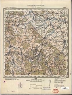
- Subject:
- Geographic Subject: Serpukhov, Topical Subject: Soviet Union, and Topical Subject: Maps
- Publisher:
- Главное управление геодезии и картографии при СНК СССР
- Language:
- Russian
- Date Created:
- 1941
- Identifier:
- VAC9619-003100
- Genre:
- Military Maps and Topographic Maps
- Geographic Location:
- Coordinates: 54.667, 37, 55, 37.5
- Related URL:
- Catalog URL: https://iucat.iu.edu/catalog/5020129 and Download GeoTIFF: https://drive.google.com/file/d/1YXi_kgRInGAQDNE3p1BfFL8ZnKZsEQ17/view?usp=sharing
- Abstract:
- Modern area represented: Serpukhov, Russia
- Call Number:
- G7000 s100 .S7 sheet N-37-39
- Caption:
- Для служебного пользования
- City:
- Серпухов (Serpukhov)
- Copyright Holder:
- No Copyright - United States
- Country:
- СССР (USSR)
- State/Province:
- Тульская область (Tula oblast), РСФСР (RSFSR), and Московская область (Moscow oblast)
- Physical Description:
- Scale: 1:100,000
- Persistent URL:
- http://purl.dlib.indiana.edu/iudl/images/VAC9619/VAC9619-003100
- Provenance:
- DMA Topographic Center, Army Map Service Library, Library of Congress Geography & Map Division
-
- Description:
- 1939
- Subject:
- Topical Subject: Soviet Union, Topical Subject: Maps, and Geographic Subject: Kravotyn'
- Publisher:
- Главное управление геодезии и картографии при СНК СССР
- Language:
- Russian
- Date Created:
- 1941
- Identifier:
- VAC9619-002841
- Genre:
- Topographic Maps and Military Maps
- Geographic Location:
- Coordinates: 57.167, 33, 57.333, 33.25
- Related URL:
- Download GeoTIFF: https://drive.google.com/file/d/1ES4pkCBJt5r7GmAOEju7JNpB3uXWh-H0/view?usp=sharing and Catalog URL: http://iucat.iu.edu/catalog/5020131
- Abstract:
- Modern area represented: Кравотынь (Kravotyn'), Тверская область (Tverskaya oblast), Russia
- Call Number:
- GM G7000 s50 .S68 sheet O-36-103-A
- Caption:
- Captured map and Для служебного пользования
- City:
- Кравотынь (Kravotyn')
- Copyright Holder:
- No Copyright - United States
- Country:
- СССР (USSR)
- State/Province:
- Калининская область (Kalinin oblast) and Осташковский район (Ostashkovsky district)
- Physical Description:
- Scale: 1:50,000
- Persistent URL:
- http://purl.dlib.indiana.edu/iudl/images/VAC9619/VAC9619-002841
- Provenance:
- DMA Topographic Center, Army Map Service Library, Library of Congress Geography & Map Division
-
- Description:
- 1881
- Subject:
- Topical Subject: Maps, Geographic Subject: Wałbrzych, and Topical Subject: Soviet Union
- Publisher:
- Генеральный штаб Красной Армии
- Language:
- Russian
- Date Created:
- 1941
- Identifier:
- VAC9619-002612
- Genre:
- Topographic Maps and Military Maps
- Geographic Location:
- Coordinates: 50.66667, 16.0, 51.0, 16.5
- Related URL:
- Download GeoTIFF: https://drive.google.com/file/d/1kFsiMhki6AQE-SCAeAGcI3MVKvGeIKR4/view?usp=sharing and Catalog URL: https://iucat.iu.edu/catalog/5020129
- Abstract:
- Modern area represented: Wałbrzych, Lower Silesian province, Poland
- Call Number:
- G7000 s100 .S7 sheet M-33-45
- City:
- Вальденбург (Waldenburg)
- Copyright Holder:
- No Copyright - United States
- Country:
- Германия (Germany)
- Physical Description:
- Scale: 1:100,000
- Persistent URL:
- http://purl.dlib.indiana.edu/iudl/images/VAC9619/VAC9619-002612
- Provenance:
- DMA Topographic Center, Army Map Service Library, Library of Congress Geography & Map Division
