
Search Constraints
You searched for:
Publisher
Генеральный штаб Красной Армии
Remove constraint Publisher: Генеральный штаб Красной Армии
Search Results
-
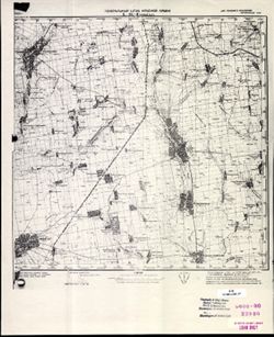
- Description:
- 1940
- Subject:
- Geographic Subject: Pavlovskaya, Topical Subject: Maps, and Topical Subject: Soviet Union
- Publisher:
- Генеральный штаб Красной Армии
- Language:
- Russian
- Date Created:
- 1941
- Identifier:
- VAC9619-002330
- Genre:
- Topographic Maps and Military Maps
- Geographic Location:
- Coordinates: 46, 39.5, 46.3333, 40
- Related URL:
- Download GeoTIFF: https://drive.google.com/file/d/1xbqEApJ5hSLMPVxfU-oodDof-dkkXh20/view?usp=sharing and Catalog URL: https://iucat.iu.edu/catalog/5020129
- Abstract:
- Modern area represented: Pavlovskaya, Russia
- Call Number:
- G7000 s100 .S7 sheet L-37-68
- Caption:
- Для служебного пользования
- City:
- Павловская (Pavlovskaya)
- Copyright Holder:
- No Copyright - United States
- Country:
- СССР (USSR)
- State/Province:
- Краснодарский край (Krasnodar kray) and РСФСР (RSFSR)
- Physical Description:
- Scale: 1:100,000
- Persistent URL:
- http://purl.dlib.indiana.edu/iudl/images/VAC9619/VAC9619-002330
- Provenance:
- DMA Topographic Center, Army Map Service Library
-
- Subject:
- Geographic Subject: Cegłów, Topical Subject: Soviet Union, and Topical Subject: Maps
- Publisher:
- Генеральный штаб Красной Армии
- Language:
- Russian
- Date Created:
- 1941
- Identifier:
- VAC9619-000336
- Genre:
- Military Maps and Topographic Maps
- Geographic Location:
- Coordinates: 52, 21.5, 52.167, 21.75
- Related URL:
- Download GeoTIFF: https://drive.google.com/open?id=1EwlXwAYp5zAgkg8DJ__OMlHFwctYLxzf and Catalog URL: http://iucat.iu.edu/catalog/5020131
- Abstract:
- Modern area represented: Cegłów, Poland
- Call Number:
- G7000 s50 .S68 sheet N-34-140-C
- Caption:
- Captured map
- City:
- Цеглув (Cegłów)
- Copyright Holder:
- No Copyright - United States
- Country:
- Область государственных интересов Германии (Region of German state interest)
- Physical Description:
- Scale: 1:50,000
- Persistent URL:
- http://purl.dlib.indiana.edu/iudl/images/VAC9619/VAC9619-000336
- Provenance:
- Army Map Service Library, OMAHA, Library of Congress Geography & Map Division
-
- Subject:
- Topical Subject: Soviet Union, Topical Subject: Maps, and Geographic Subject: Biesal
- Publisher:
- Генеральный штаб Красной Армии
- Language:
- Russian
- Date Created:
- 1941
- Identifier:
- VAC9619-003838
- Genre:
- Topographic Maps and Military Maps
- Geographic Location:
- Coordinates: 53.667, 20.125, 53.75, 20.25
- Related URL:
- Download GeoTIFF: https://drive.google.com/file/d/1vevnljNJ4E3HJI_kLkPJpL1_JMOzXOXj/view?usp=sharing and Catalog URL: https://iucat.iu.edu/catalog/14701157
- Abstract:
- Modern area represented: Biesal, Poland
- Call Number:
- G7063.K2 s25 .S6 sheet N-34-77-C-d
- City:
- Бисселен (Biessellen)
- Copyright Holder:
- No Copyright - United States
- Country:
- Германия (Восточная Пруссия) (Germany (East Prussia))
- Physical Description:
- Scale: 1:25,000
- Persistent URL:
- http://purl.dlib.indiana.edu/iudl/images/VAC9619/VAC9619-003838
- Provenance:
- Army Map Service Library, Library of Congress Geography & Map Division
-
- Description:
- 1891
- Subject:
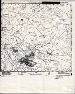
- Topical Subject: Maps, Topical Subject: Soviet Union, and Geographic Subject: Piotrków Trybunalski
- Publisher:
- Генеральный штаб Красной Армии
- Language:
- Russian
- Date Created:
- 1940
- Identifier:
- VAC9619-002750
- Genre:
- Military Maps and Topographic Maps
- Geographic Location:
- Coordinates: 51.333, 19.5, 51.667, 20
- Related URL:
- Download GeoTIFF: https://drive.google.com/file/d/1wRwSFQwGKu57AUm2kuh8MYECeZZYxWlG/view?usp=sharing and Catalog URL: https://iucat.iu.edu/catalog/5020129
- Abstract:
- Modern area represented: Piotrków Trybunalski, Łódź province, Poland
- Call Number:
- G7000 s100 .S7 sheet M-34-16
- City:
- Пиотркув (Piotrków)
- Copyright Holder:
- No Copyright - United States
- State/Province:
- Область государственных интересов Германии (Region of German state interests)
- Physical Description:
- Scale: 1:100,000
- Persistent URL:
- http://purl.dlib.indiana.edu/iudl/images/VAC9619/VAC9619-002750
- Provenance:
- DMA Topographic Center, Library of Congress Geography & Map Division, Army Map Service Library, Geographic Names Branch, OMAHA
-
- Description:
- 1923
- Subject:
- Geographic Subject: Kazatskiye Bolsuny, Topical Subject: Maps, and Topical Subject: Soviet Union
- Publisher:
- Генеральный штаб Красной Армии
- Language:
- Russian
- Date Created:
- 1941
- Identifier:
- VAC9619-001986
- Genre:
- Military Maps and Topographic Maps
- Geographic Location:
- Coordinates: 52.6667, 31, 53, 31.5
- Related URL:
- Catalog URL: https://iucat.iu.edu/catalog/5020129 and Download GeoTIFF: https://drive.google.com/open?id=1NGZ48urLJWivl2Kfpc8aCV_5puUGsbqS
- Abstract:
- Modern area represented: Kazatskiye Bolsuny, Homyel voblasc, Belarus
- Call Number:
- G7000 s100 .S7 sheet N-36-111
- Caption:
- Для служебного пользования
- City:
- Казацкие Болсуны (Kazatskiye Bolsuny)
- Copyright Holder:
- No Copyright - United States
- Country:
- СССР (USSR)
- State/Province:
- РСФСР (RSFSR), Орловская область (Oryol oblast), Белорусская ССР (Byelorussian Soviet Socialist Republic), and Гомельская область (Homyel oblast)
- Physical Description:
- Scale: 1:100,000
- Persistent URL:
- http://purl.dlib.indiana.edu/iudl/images/VAC9619/VAC9619-001986
- Provenance:
- DMA Topographic Center, Army Map Service Library, Geographic Names Branch, Atlasblatt, OMAHA
-
- Description:
- 1941
- Subject:
- Topical Subject: Maps, Topical Subject: Soviet Union, and Geographic Subject: Koltan-Nur lake
- Publisher:
- Генеральный штаб Красной Армии
- Language:
- Russian
- Date Created:
- 1942
- Identifier:
- VAC9619-002166
- Genre:
- Military Maps and Topographic Maps
- Geographic Location:
- Coordinates: 45.3333, 45.5, 45.6667, 46
- Related URL:
- Download GeoTIFF: https://drive.google.com/open?id=1TbdH0pLoQrfNjccE9h9zqh8Dh0XLyveo and Catalog URL: https://iucat.iu.edu/catalog/5020129
- Abstract:
- Modern area represented: Koltan-Nur lake, Kalmykiya Republic, Russia
- Call Number:
- G7000 s100 .S7 sheet L-38-92
- Caption:
- Для служебного пользования
- City:
- Оз. Колтан-Нур (Koltan-Nur lake)
- Copyright Holder:
- No Copyright - United States
- Country:
- СССР (USSR)
- State/Province:
- Калмыцкая АССР (Kalmyk Autonomous Soviet Socialist Republic) and РСФСР (RSFSR)
- Physical Description:
- Scale: 1:100,000
- Persistent URL:
- http://purl.dlib.indiana.edu/iudl/images/VAC9619/VAC9619-002166
- Provenance:
- CIA Map Library
-
- Subject:
- Topical Subject: Maps, Topical Subject: Soviet Union, and Geographic Subject: Gołymin-Ośrodek
- Publisher:
- Генеральный штаб Красной Армии
- Language:
- Russian
- Date Created:
- 1941
- Identifier:
- VAC9619-000380
- Genre:
- Topographic Maps and Military Maps
- Geographic Location:
- Coordinates: 52.6667, 20.75, 52.8333, 21
- Related URL:
- Download GeoTIFF: https://drive.google.com/open?id=1TK2aF8RMGAbdEVm4XuSX3vzj2tJntdbW and Catalog URL: http://iucat.iu.edu/catalog/5020131
- Abstract:
- Modern area represented: Gołymin-Ośrodek, Poland
- Call Number:
- G7000 s50 .S68 sheet N-114-D
- Caption:
- Captured map
- City:
- Голымин Стары
- Copyright Holder:
- No Copyright - United States
- Country:
- Область государственных интересов Германии (Region of German state interest)
- Physical Description:
- Scale: 1:50,000
- Persistent URL:
- http://purl.dlib.indiana.edu/iudl/images/VAC9619/VAC9619-000380
- Provenance:
- Army Map Service Library, OMAHA, Library of Congress Geography & Map Division
-
- Description:
- 1923
- Subject:
- Topical Subject: Soviet Union, Geographic Subject: Homyel, and Topical Subject: Maps
- Publisher:
- Генеральный штаб Красной Армии
- Language:
- Russian
- Identifier:
- VAC9619-004202
- Genre:
- Topographic Maps and Military Maps
- Geographic Location:
- Coordinates: 52.333, 31, 52.667, 31.5
- Related URL:
- Download GeoTIFF: https://drive.google.com/file/d/1pXEq-VaGRQdXV1IiPcXsu6UB79wQxjFi/view?usp=sharing and Catalog URL: https://iucat.iu.edu/catalog/5020129
- Abstract:
- Modern area represented: Homyel, Homyel oblast, Belarus
- Call Number:
- G7000 s100 .S7 sheet N-36-123
- City:
- Гомель (Homyel)
- Copyright Holder:
- No Copyright - United States
- Country:
- СССР (USSR)
- State/Province:
- Гомельская область (Homyel oblast) and Белорусская ССР (Byelorussian Soviet Socialist Republic)
- Physical Description:
- Scale: 1:100,000
- Persistent URL:
- http://purl.dlib.indiana.edu/iudl/images/VAC9619/VAC9619-004202
- Provenance:
- DMA Topographic Center, Auswärtiges Amt. Geographischer Dienst, OMAHA, Army Map Service Library
-
- Description:
- 1930
- Subject:
- Topical Subject: Maps, Geographic Subject: Novyy Buh, and Topical Subject: Soviet Union
- Publisher:
- Генеральный штаб Красной Армии
- Language:
- Russian
- Date Created:
- 1941
- Identifier:
- VAC9619-001863
- Genre:
- Military Maps and Topographic Maps
- Geographic Location:
- Coordinates: 47.6667, 32.5, 48, 33
- Related URL:
- Download GeoTIFF: https://drive.google.com/open?id=1T0wPHo0RpDwORrKZXGfpt1IyrZgBA6b4 and Catalog URL: https://iucat.iu.edu/catalog/5020129
- Abstract:
- Modern area represented: Novyy Buh, Mykolaiv, Ukraine
- Call Number:
- G7000 s100 .S7 sheet L-36-6
- Caption:
- Для служебного пользования
- City:
- Новый Буг (Novyy Buh)
- Copyright Holder:
- No Copyright - United States
- Country:
- СССР (USSR)
- State/Province:
- Украинская ССР (Ukrainian Soviet Socialist Republic)
- Physical Description:
- Scale: 1:100,000
- Persistent URL:
- http://purl.dlib.indiana.edu/iudl/images/VAC9619/VAC9619-001863
- Provenance:
- CIA Map Library
-

- Description:
- 1928
- Subject:
- Topical Subject: Soviet Union, Geographic Subject: Yahotyn, and Topical Subject: Maps
- Publisher:
- Генеральный штаб Красной Армии
- Language:
- Russian
- Date Created:
- 1941
- Identifier:
- VAC9619-003293
- Genre:
- Topographic Maps and Military Maps
- Geographic Location:
- Coordinates: 50, 31.5, 50.333, 32
- Related URL:
- Catalog URL: https://iucat.iu.edu/catalog/5020129 and Download GeoTIFF: https://drive.google.com/file/d/1LHmrE7SLHHk3jOpjngs2HIPoYbavjsT9/view?usp=sharing
- Abstract:
- Modern area represented: Yahotyn, Kiev oblast, Ukraine
- Call Number:
- G7000 s100 .S7 sheet M-36-64
- City:
- Яготин (Yahotyn)
- Copyright Holder:
- No Copyright - United States
- Country:
- СССР (USSR)
- State/Province:
- Черниговская область (Chernihiv oblast), Киевская область (Kyiv oblast), Украинская ССР (Ukrainian Soviet Socialist Republic), and Полтавская область (Poltav...
- Physical Description:
- Scale: 1:100,000
- Persistent URL:
- http://purl.dlib.indiana.edu/iudl/images/VAC9619/VAC9619-003293
- Provenance:
- DMA Topographic Center, Army Map Service Library, OMAHA, Library of Congress Geography & Map Division
