
Search Constraints
You searched for:
Country
СССР (USSR)
Remove constraint Country: СССР (USSR)
Date Created
1941
Remove constraint Date Created: 1941
Holding Location
B-WELLS
Remove constraint Holding Location: B-WELLS
State/Province
Калининская область (Kalinin oblast)
Remove constraint State/Province: Калининская область (Kalinin oblast)
« Previous |
1 - 10 of 94
|
Next »
Search Results
-

- Description:
- 1939
- Subject:
- Topical Subject: Soviet Union, Geographic Subject: Karmanovo, and Topical Subject: Maps
- Publisher:
- Генеральный штаб Красной Армии
- Language:
- Russian
- Date Created:
- 1941
- Identifier:
- VAC9619-004150
- Genre:
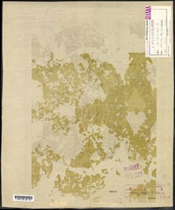
- Topographic Maps and Military Maps
- Geographic Location:
- Coordinates: 55.667, 34.5, 56, 35
- Related URL:
- DataCORE Dataset Download: https://datacore.iu.edu/concern/data_sets/fq977v625
- Abstract:
- Modern area represented: Karmanovo, Russia
- Call Number:
- G7000 s100 .S7 sheet N-36-10
- City:
- Карманово (Karmanovo)
- Copyright Holder:
- No Copyright - United States
- Country:
- СССР (USSR)
- State/Province:
- РСФСР (RSFSR), Калининская область (Kalinin oblast), and Смоленская область (Smolensk oblast)
- Physical Description:
- Scale: 1:100,000
- Persistent URL:
- http://purl.dlib.indiana.edu/iudl/images/VAC9619/VAC9619-004150
- Provenance:
- DMA Topographic Center, Army Map Service Library, OMAHA
-
- Description:
- 1926
- Subject:
- Topical Subject: Soviet Union, Topical Subject: Maps, and Geographic Subject: Kresty
- Publisher:
- Генеральный штаб Красной Армии
- Language:
- Russian
- Date Created:
- 1941
- Identifier:
- VAC9619-004148
- Genre:
- Topographic Maps and Military Maps
- Geographic Location:
- Coordinates: 55.667, 31, 56, 31.5
- Related URL:
- DataCORE Dataset Download: https://datacore.iu.edu/concern/data_sets/ms35t9473
- Abstract:
- Modern area represented: Kresty, Russia
- Call Number:
- G7000 s100 .S7 sheet N-36-3
- Caption:
- Для служебного пользования
- City:
- Кресты (Kresty)
- Copyright Holder:
- No Copyright - United States
- Country:
- СССР (USSR)
- State/Province:
- Калининская область (Kalinin oblast), Смоленская область (Smolensk oblast), and РСФСР (RSFSR)
- Physical Description:
- Scale: 1:100,000
- Persistent URL:
- http://purl.dlib.indiana.edu/iudl/images/VAC9619/VAC9619-004148
- Provenance:
- DMA Topographic Center, Army Map Service Library, OMAHA
-
- Description:
- 1938
- Subject:
- Topical Subject: Maps, Geographic Subject: Bol’shoye Ploskoye, and Topical Subject: Soviet Union
- Publisher:
- Главное управление геодезии и картографии при СНК СССР
- Language:
- Russian
- Date Created:
- 1941
- Identifier:
- VAC9619-003537
- Genre:
- Topographic Maps and Military Maps
- Geographic Location:
- Coordinates: 57.5, 35.25, 57.667, 35.5
- Related URL:
- DataCORE Dataset Download: https://datacore.iu.edu/concern/data_sets/gq67js09h
- Abstract:
- Modern area represented: Bolshoye Ploskoye, Tverskaya oblast, Russia
- Call Number:
- GM G7000 s50 .S68 sheet O-36-95-B
- Caption:
- Для служебного пользования
- City:
- Большое Плоское (Bolshoye Ploskoye)
- Copyright Holder:
- No Copyright - United States
- Country:
- СССР (USSR)
- State/Province:
- Калининская область (Kalinin oblast)
- Physical Description:
- Scale: 1:50,000
- Persistent URL:
- http://purl.dlib.indiana.edu/iudl/images/VAC9619/VAC9619-003537
- Provenance:
- Army Map Service Library, Library of Congress International Exchange Division of Maps
-
- Description:
- 1938
- Subject:
- Geographic Subject: Zhilotkovo, Topical Subject: Maps, and Topical Subject: Soviet Union
- Publisher:
- Главное управление геодезии и картографии при СНК СССР
- Language:
- Russian
- Date Created:
- 1941
- Identifier:
- VAC9619-003536
- Genre:
- Military Maps and Topographic Maps
- Geographic Location:
- Coordinates: 57.5, 34, 57.667, 34.25
- Related URL:
- DataCORE Dataset Download: https://datacore.iu.edu/concern/data_sets/sn009z84g
- Abstract:
- Modern area represented: Жилотково (Zhilotkovo), Tverskaya oblast, Russia
- Call Number:
- GM G7000 s50 .S68 sheet O-36-93-A
- City:
- Жилотково (Zhilotkovo)
- Copyright Holder:
- No Copyright - United States
- Country:
- СССР (USSR)
- State/Province:
- Бологовский район (Bologovsky district), Вышневолоцкий район (Vyshnevolotsky district), and Калининская область (Kalinin oblast)
- Physical Description:
- Scale: 1:50,000
- Persistent URL:
- http://purl.dlib.indiana.edu/iudl/images/VAC9619/VAC9619-003536
- Provenance:
- DMA Topographic Center, Army Map Service Library, OMAHA, Library of Congress Geography & Map Division
-
- Description:
- 1939
- Subject:
- Topical Subject: Maps, Geographic Subject: Kostruble, and Topical Subject: Soviet Union
- Publisher:
- Главное управление геодезии и картографии при СНК СССР
- Language:
- Russian
- Date Created:
- 1941
- Identifier:
- VAC9619-003535
- Genre:
- Topographic Maps and Military Maps
- Geographic Location:
- Coordinates: 57.3333, 33.5, 57.5, 33.75
- Related URL:
- DataCORE Dataset Download: https://datacore.iu.edu/concern/data_sets/v118rf21c
- Abstract:
- Modern area represented: Кострубле (Kostruble), Tverskaya oblast, Russia
- Call Number:
- GM G7000 s50 .S68 sheet O-36-92-C
- Caption:
- Для служебного пользования
- City:
- Каструбли (Kastrubli)
- Copyright Holder:
- No Copyright - United States
- Country:
- СССР (USSR)
- State/Province:
- Фировский район (Firovsky district), Калининская область (Kalinin oblast), and Осташковский район (Ostashkovsky district)
- Physical Description:
- Scale: 1:50,000
- Persistent URL:
- http://purl.dlib.indiana.edu/iudl/images/VAC9619/VAC9619-003535
- Provenance:
- DMA Topographic Center, Army Map Service Library, OMAHA, Library of Congress Geography & Map Division
-
- Description:
- 1938
- Subject:
- Geographic Subject: Selikhovo, Topical Subject: Maps, and Topical Subject: Soviet Union
- Publisher:
- Главное управление геодезии и картографии при СНК СССР
- Language:
- Russian
- Date Created:
- 1941
- Identifier:
- VAC9619-003523
- Genre:
- Topographic Maps and Military Maps
- Geographic Location:
- Coordinates: 56.5, 36.75, 56.667, 37
- Related URL:
- DataCORE Dataset Download: https://datacore.iu.edu/concern/data_sets/dn39x2299
- Abstract:
- Modern area represented: Селихово (Selikhovo), Tverskaya oblast, Russia
- Call Number:
- GM G7000 s50 .S68 sheet O-37-122-B
- City:
- Селехово (Selekhovo)
- Copyright Holder:
- No Copyright - United States
- Country:
- СССР (USSR)
- State/Province:
- Калининская область (Kalinin oblast), Клинский район (Klinsky district), Московская область (Moscow oblast), Конаковский район (Konakovsky district), and Зав...
- Physical Description:
- Scale: 1:50,000
- Persistent URL:
- http://purl.dlib.indiana.edu/iudl/images/VAC9619/VAC9619-003523
- Provenance:
- DMA Topographic Center, Army Map Service Library, OMAHA, Library of Congress Geography & Map Division
-
- Description:
- 1938
- Subject:
- Topical Subject: Maps, Geographic Subject: Konakovo, and Topical Subject: Soviet Union
- Publisher:
- Главное управление государственной съемки и картографии НКВД СССР
- Language:
- Russian
- Date Created:
- 1941
- Identifier:
- VAC9619-003522
- Genre:
- Topographic Maps and Military Maps
- Geographic Location:
- Coordinates: 56.667, 36.75, 56.833, 37
- Related URL:
- DataCORE Dataset Download: https://datacore.iu.edu/concern/data_sets/7h149q65n
- Abstract:
- Modern area represented: Конаково (Konakovo), Tverskaya oblast, Russia
- Call Number:
- GM G7000 s50 .S68 sheet O-37-110-D
- City:
- Конаково (Konakovo)
- Copyright Holder:
- No Copyright - United States
- Country:
- СССР (USSR)
- State/Province:
- Калининская область (Kalinin oblast), Оршинский район (Orshinsky district), Конаковский район (Konakovsky district), and Кимрский район (Kimrsky district)
- Physical Description:
- Scale: 1:50,000
- Persistent URL:
- http://purl.dlib.indiana.edu/iudl/images/VAC9619/VAC9619-003522
- Provenance:
- DMA Topographic Center, Army Map Service Library, OMAHA, Library of Congress Geography & Map Division
-

- Description:
- 1939
- Subject:
- Geographic Subject: Gorodkovo, Topical Subject: Soviet Union, and Topical Subject: Maps
- Publisher:
- Главное управление геодезии и картографии при СНК СССР
- Language:
- Russian
- Date Created:
- 1941
- Identifier:
- VAC9619-003512
- Genre:
- Topographic Maps and Military Maps
- Geographic Location:
- Coordinates: 56.0, 35.25, 56.16667, 35.5
- Related URL:
- DataCORE Dataset Download: https://datacore.iu.edu/concern/data_sets/5x21tg08m
- Abstract:
- Modern area represented: Городково (Gorodkovo), Moscow oblast, Russia
- Call Number:
- GM G7000 s50 .S68 sheet O-36-143-D
- City:
- Городково (Gorodkovo)
- Copyright Holder:
- No Copyright - United States
- Country:
- СССР (USSR)
- State/Province:
- Шаховской район (Shakhovsky district), Калининская область (Kalinin oblast), Московская область (Moscow oblast), and Погорельский район (Pogorelsky district)
- Physical Description:
- Scale: 1:50,000
- Persistent URL:
- http://purl.dlib.indiana.edu/iudl/images/VAC9619/VAC9619-003512
- Provenance:
- DMA Topographic Center, Army Map Service Library, OMAHA, Library of Congress Geography & Map Division
-
- Description:
- 1939
- Subject:
- Geographic Subject: Dorozhayevo, Topical Subject: Soviet Union, and Topical Subject: Maps
- Publisher:
- Главное управление геодезии и картографии при СНК СССР
- Language:
- Russian
- Date Created:
- 1941
- Identifier:
- VAC9619-003511
- Genre:
- Topographic Maps and Military Maps
- Geographic Location:
- Coordinates: 56.16667, 35.25, 56.3333, 35.5
- Related URL:
- DataCORE Dataset Download: https://datacore.iu.edu/concern/data_sets/qz20st29r
- Abstract:
- Modern area represented: Дорожаево (Dorozhayevo), Tverskaya oblast, Russia
- Call Number:
- GM G7000 s50 .S68 sheet O-36-143-B
- City:
- Дорожаево (Dorozhayevo)
- Copyright Holder:
- No Copyright - United States
- Country:
- СССР (USSR)
- State/Province:
- Калининская область (Kalinin oblast), Московская область (Moscow oblast), Старицкий район (Staritsky district), Лотошинский район (Lotoshinsky district), Шах...
- Physical Description:
- Scale: 1:50,000
- Persistent URL:
- http://purl.dlib.indiana.edu/iudl/images/VAC9619/VAC9619-003511
- Provenance:
- M. I. Map Library, Library of Congress Geography & Map Division
-
- Description:
- 1939
- Subject:
- Topical Subject: Maps, Topical Subject: Soviet Union, and Geographic Subject: Mozzharino
- Publisher:
- Главное управление геодезии и картографии при СНК СССР
- Language:
- Russian
- Date Created:
- 1941
- Identifier:
- VAC9619-003509
- Genre:
- Topographic Maps and Military Maps
- Geographic Location:
- Coordinates: 56, 34.5, 56.167, 34.75
- Related URL:
- DataCORE Dataset Download: https://datacore.iu.edu/concern/data_sets/cr56n175s
- Abstract:
- Modern area represented: part of Зубцов (Zubtsov), Tverskaya oblast, Russia
- Call Number:
- GM G7000 s50 .S68 sheet O-36-142-C
- City:
- Мозжарино (Mozzharino)
- Copyright Holder:
- No Copyright - United States
- Country:
- СССР (USSR)
- State/Province:
- РСФСР (RSFSR) and Калининская область (Kalinin oblast)
- Physical Description:
- Scale: 1:50,000
- Persistent URL:
- http://purl.dlib.indiana.edu/iudl/images/VAC9619/VAC9619-003509
- Provenance:
- DMA Topographic Center, Army Map Service Library, OMAHA, Library of Congress Geography & Map Division
