
Search Constraints
You searched for:
County
Cochise
Remove constraint County: Cochise
State/Province
Arizona
Remove constraint State/Province: Arizona
« Previous |
1 - 50 of 58
|
Next »
Search Results
-
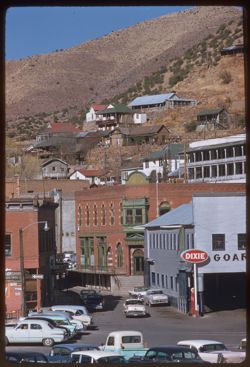
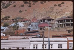
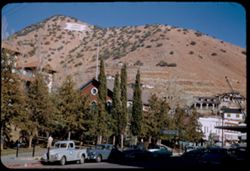
- Description:
- 100 f 6.3 tl
- Subject:
- Brewery Gulch (Ariz.), Electric lines, Automobiles, Signs (Notices), Streets, Cities & towns, Street lights, Shrubs, Dwellings, Hills, People, Valleys, a...
- Series:
- 7-59
- Creator:
- Cushman, Charles W., 1896-1972
- Date Created:
- 1959-02-06
- Genre:
- Cityscape photographs
- Frame Number:
- 35
- County:
- Cochise
- Call Number:
- P10611
- City:
- Bisbee
- Country:
- United States
- State/Province:
- Arizona
- Alternate Identifier:
- 759.35
- Persistent URL:
- http://purl.dlib.indiana.edu/iudl/archives/cushman/P10611
- Holding Location:
- Bloomington - University Archives
Wells Library E460
1320 E 10th St.
Bloomington, IN 47405
Contact at archives@indiana.edu, 812-855-1127
-
- Description:
- 100 f 6.3 tl
- Subject:
- Walls, Roads, Automobiles, Trees, Buildings, Shrubs, Dwellings, Hills, and Rocks
- Series:
- 7-59
- Creator:
- Cushman, Charles W., 1896-1972
- Date Created:
- 1959-02-06
- Genre:
- Cityscape photographs
- Frame Number:
- 34
- County:
- Cochise
- Abstract:
- Bisbee
- Call Number:
- P10610
- City:
- Bisbee
- Country:
- United States
- State/Province:
- Arizona
- Alternate Identifier:
- 759.34
- Persistent URL:
- http://purl.dlib.indiana.edu/iudl/archives/cushman/P10610
- Holding Location:
- Bloomington - University Archives
Wells Library E460
1320 E 10th St.
Bloomington, IN 47405
Contact at archives@indiana.edu, 812-855-1127
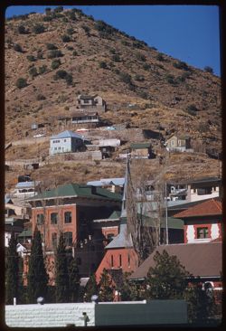
-
- Description:
- 100 f 6.3 tl
- Subject:
- Domes, Clock towers, Hills, Street lights, Windows, Shrubs, Electric lines, Trees, Buildings, Signs (Notices), and Dwellings
- Series:
- 7-59
- Creator:
- Cushman, Charles W., 1896-1972
- Date Created:
- 1959-02-06
- Genre:
- Cityscape photographs
- Frame Number:
- 33
- County:
- Cochise
- Call Number:
- P10609
- City:
- Bisbee
- Country:
- United States
- State/Province:
- Arizona
- Alternate Identifier:
- 759.33
- Persistent URL:
- http://purl.dlib.indiana.edu/iudl/archives/cushman/P10609
- Holding Location:
- Bloomington - University Archives
Wells Library E460
1320 E 10th St.
Bloomington, IN 47405
Contact at archives@indiana.edu, 812-855-1127
-
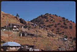
- Description:
- 100 f 6.3 tl
- Subject:
- Walls, Electric lines, Trees, Cities & towns, Shrubs, Dwellings, Hills, People, and Rocks
- Series:
- 7-59
- Creator:
- Cushman, Charles W., 1896-1972
- Date Created:
- 1959-02-06
- Genre:
- Cityscape photographs
- Frame Number:
- 32
- County:
- Cochise
- Abstract:
- Bisbee- a red hill
- Call Number:
- P10608
- City:
- Bisbee
- Country:
- United States
- State/Province:
- Arizona
- Alternate Identifier:
- 759.32
- Persistent URL:
- http://purl.dlib.indiana.edu/iudl/archives/cushman/P10608
- Holding Location:
- Bloomington - University Archives
Wells Library E460
1320 E 10th St.
Bloomington, IN 47405
Contact at archives@indiana.edu, 812-855-1127
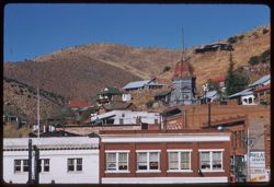
-
- Description:
- 100 f 6.3 tl
- Subject:
- Electric lines, Trees, Signs (Notices), Cities & towns, Buildings, Shrubs, Masonry, Dwellings, Domes, Clock towers, and Hills
- Series:
- 7-59
- Creator:
- Cushman, Charles W., 1896-1972
- Date Created:
- 1959-02-06
- Genre:
- Cityscape photographs
- Frame Number:
- 31
- County:
- Cochise
- Abstract:
- Bisbee- old dome
- Call Number:
- P10607
- City:
- Bisbee
- Country:
- United States
- State/Province:
- Arizona
- Alternate Identifier:
- 759.31
- Persistent URL:
- http://purl.dlib.indiana.edu/iudl/archives/cushman/P10607
- Holding Location:
- Bloomington - University Archives
Wells Library E460
1320 E 10th St.
Bloomington, IN 47405
Contact at archives@indiana.edu, 812-855-1127
-
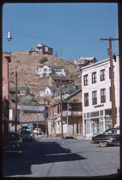
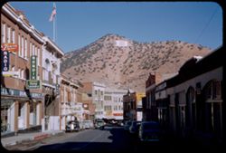
- Description:
- 50 f 8 tl
- Subject:
- Valleys, Hills, Automobiles, Street lights, Dwellings, Electric lines, Buildings, Brewery Gulch (Ariz.), Signs (Notices), Streets, and Shrubs
- Series:
- 7-59
- Creator:
- Cushman, Charles W., 1896-1972
- Date Created:
- 1959-02-06
- Genre:
- Cityscape photographs
- Frame Number:
- 30
- County:
- Cochise
- Abstract:
- View up Brewery Gulch
- Call Number:
- P10606
- City:
- Bisbee
- Country:
- United States
- State/Province:
- Arizona
- Alternate Identifier:
- 759.30
- Persistent URL:
- http://purl.dlib.indiana.edu/iudl/archives/cushman/P10606
- Holding Location:
- Bloomington - University Archives
Wells Library E460
1320 E 10th St.
Bloomington, IN 47405
Contact at archives@indiana.edu, 812-855-1127
-
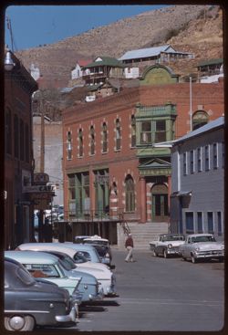
- Description:
- 50 f 9 tl
- Subject:
- Streets, Hills, Automobiles, Street lights, Taxicabs, Mountains, People, Dwellings, Electric lines, Buildings, Brewery Gulch (Ariz.), Signs (Notices), and Sh...
- Series:
- 7-59
- Creator:
- Cushman, Charles W., 1896-1972
- Date Created:
- 1959-02-06
- Genre:
- Cityscape photographs
- Frame Number:
- 29
- County:
- Cochise
- Abstract:
- Brewery Gulch
- Call Number:
- P10605
- City:
- Bisbee
- Country:
- United States
- State/Province:
- Arizona
- Alternate Identifier:
- 759.29
- Persistent URL:
- http://purl.dlib.indiana.edu/iudl/archives/cushman/P10605
- Holding Location:
- Bloomington - University Archives
Wells Library E460
1320 E 10th St.
Bloomington, IN 47405
Contact at archives@indiana.edu, 812-855-1127
-
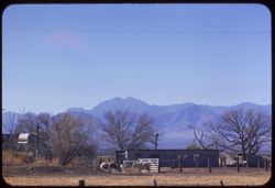
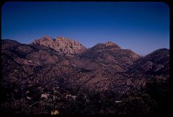
- Description:
- 100 f 6.3 tl
- Subject:
- Fences, Mountains, Trees, Dwellings, Horses, Electric lines, Shrubs, and Cochise Head (Ariz.)
- Series:
- 5-59
- Creator:
- Cushman, Charles W., 1896-1972
- Date Created:
- 1959-01-23
- Genre:
- Landscape photographs
- Frame Number:
- 36
- Street Address:
- Arizona State Highway 86
- County:
- Cochise
- Abstract:
- Cochise Head from Ariz Hwy 86
- Call Number:
- P10537
- Country:
- United States
- State/Province:
- Arizona
- Alternate Identifier:
- 559.36
- Persistent URL:
- http://purl.dlib.indiana.edu/iudl/archives/cushman/P10537
- Holding Location:
- Bloomington - University Archives
Wells Library E460
1320 E 10th St.
Bloomington, IN 47405
Contact at archives@indiana.edu, 812-855-1127
-
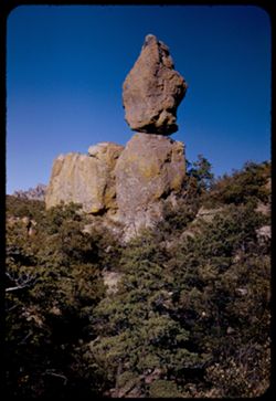
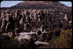
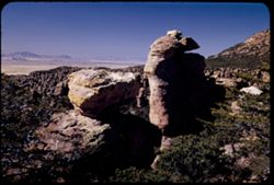
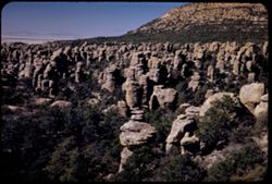
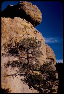
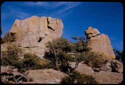
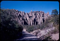
- Description:
- 50 f 11
- Subject:
- Canyons, Trees, National parks & reserves, Chiricahua National Monument (Ariz.), and Rock formations
- Series:
- 4-52
- Creator:
- Cushman, Charles W., 1896-1972
- Date Created:
- 1952-01-27
- Genre:
- Landscape photographs
- Frame Number:
- 39
- County:
- Cochise
- Abstract:
- Big balanced rock
- Call Number:
- P05645
- Country:
- United States
- State/Province:
- Arizona
- Alternate Identifier:
- 452.39
- Persistent URL:
- http://purl.dlib.indiana.edu/iudl/archives/cushman/P05645
- Holding Location:
- Bloomington - University Archives
Wells Library E460
1320 E 10th St.
Bloomington, IN 47405
Contact at archives@indiana.edu, 812-855-1127
-
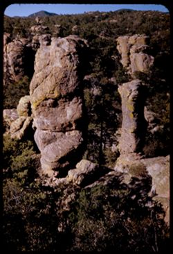
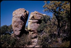
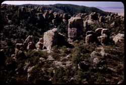
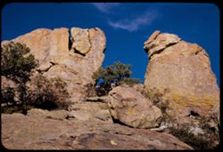
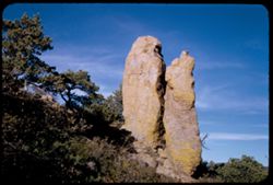
- Description:
- 25 f 13
- Subject:
- Canyons, Trees, Mountains, Rock formations, Chiricahua National Monument (Ariz.), and National parks & reserves
- Series:
- 4-52
- Creator:
- Cushman, Charles W., 1896-1972
- Date Created:
- 1952-01-27
- Genre:
- Landscape photographs
- Frame Number:
- 38
- County:
- Cochise
- Abstract:
- Two tall chimney rocks from above
- Call Number:
- P05644
- Country:
- United States
- State/Province:
- Arizona
- Alternate Identifier:
- 452.38
- Persistent URL:
- http://purl.dlib.indiana.edu/iudl/archives/cushman/P05644
- Holding Location:
- Bloomington - University Archives
Wells Library E460
1320 E 10th St.
Bloomington, IN 47405
Contact at archives@indiana.edu, 812-855-1127
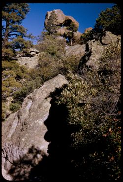
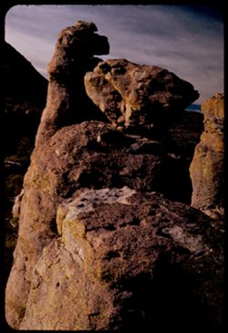
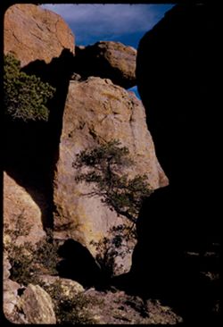
-
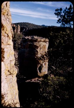
- Description:
- 25 f 15
- Subject:
- Canyons, Trees, Shadows, Tree limbs, National parks & reserves, Chiricahua National Monument (Ariz.), and Rock formations
- Series:
- 4-52
- Creator:
- Cushman, Charles W., 1896-1972
- Date Created:
- 1952-01-22
- Genre:
- Landscape photographs
- Frame Number:
- 37
- County:
- Cochise
- Abstract:
- On Echo Canyon Trail - High balanced rock with peepholes
- Call Number:
- P05643
- Country:
- United States
- State/Province:
- Arizona
- Alternate Identifier:
- 452.37
- Persistent URL:
- http://purl.dlib.indiana.edu/iudl/archives/cushman/P05643
- Holding Location:
- Bloomington - University Archives
Wells Library E460
1320 E 10th St.
Bloomington, IN 47405
Contact at archives@indiana.edu, 812-855-1127
-
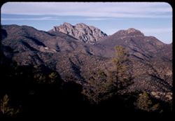
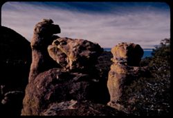
- Description:
- 25 f 16
- Subject:
- Trees, Mountains, National parks & reserves, Massai Point (Ariz.), Chiricahua National Monument (Ariz.), Shrubs, and Rock formations
- Series:
- 4-52
- Creator:
- Cushman, Charles W., 1896-1972
- Date Created:
- 1952-01-27
- Genre:
- Landscape photographs
- Frame Number:
- 36
- County:
- Cochise
- Abstract:
- Two high rocks from top of Massai - Elev. 6871 ft.
- Call Number:
- P05642
- Country:
- United States
- State/Province:
- Arizona
- Alternate Identifier:
- 452.36
- Persistent URL:
- http://purl.dlib.indiana.edu/iudl/archives/cushman/P05642
- Holding Location:
- Bloomington - University Archives
Wells Library E460
1320 E 10th St.
Bloomington, IN 47405
Contact at archives@indiana.edu, 812-855-1127
-
- Description:
- 25 f 12 pola but at 180 degrees
- Subject:
- Trees, Mountains, National parks & reserves, Massai Point (Ariz.), Chiricahua National Monument (Ariz.), Cochise Head (Ariz.), and Rock formations
- Series:
- 4-52
- Creator:
- Cushman, Charles W., 1896-1972
- Date Created:
- 1952-01-27
- Genre:
- Landscape photographs
- Frame Number:
- 35
- County:
- Cochise
- Abstract:
- North toward Cochise Head from Orientation Pt.
- Call Number:
- P05641
- Country:
- United States
- State/Province:
- Arizona
- Alternate Identifier:
- 452.35
- Persistent URL:
- http://purl.dlib.indiana.edu/iudl/archives/cushman/P05641
- Holding Location:
- Bloomington - University Archives
Wells Library E460
1320 E 10th St.
Bloomington, IN 47405
Contact at archives@indiana.edu, 812-855-1127
-
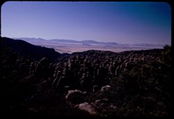
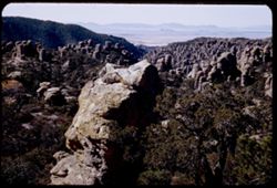
- Description:
- 25 f 9 pola
- Subject:
- Valleys, Rhyolite Canyon (Ariz.), Trees, Mountains, Rock formations, Massai Point (Ariz.), Chiricahua National Monument (Ariz.), Canyons, and National parks ...
- Series:
- 4-52
- Creator:
- Cushman, Charles W., 1896-1972
- Date Created:
- 1952-01-27
- Genre:
- Landscape photographs
- Frame Number:
- 34
- County:
- Cochise
- Abstract:
- West down Rhyolite Canyon from the top (Orientation Pt.)
- Call Number:
- P05640
- Country:
- United States
- State/Province:
- Arizona
- Alternate Identifier:
- 452.34
- Persistent URL:
- http://purl.dlib.indiana.edu/iudl/archives/cushman/P05640
- Holding Location:
- Bloomington - University Archives
Wells Library E460
1320 E 10th St.
Bloomington, IN 47405
Contact at archives@indiana.edu, 812-855-1127
-
![Looking west down canyon from Massai Point [6871 ft.] Chiricahua.](https://iiif.uits.iu.edu/iiif/2/tt44pn34n%2Ffiles%2Ff377bb81-e32d-4ee6-a938-18f32607084c/full/250,/0/default.jpg)
- Description:
- 25 f pola
- Subject:
- National parks & reserves, Canyons, Valleys, Massai Point (Ariz.), Mountains, Trees, Chiricahua National Monument (Ariz.), and Rock formations
- Series:
- 4-52
- Creator:
- Cushman, Charles W., 1896-1972
- Date Created:
- 1952-01-27
- Genre:
- Landscape photographs
- Frame Number:
- 33
- County:
- Cochise
- Abstract:
- West down canyon from Massai
- Call Number:
- P05639
- Country:
- United States
- State/Province:
- Arizona
- Alternate Identifier:
- 452.33
- Persistent URL:
- http://purl.dlib.indiana.edu/iudl/archives/cushman/P05639
- Holding Location:
- Bloomington - University Archives
Wells Library E460
1320 E 10th St.
Bloomington, IN 47405
Contact at archives@indiana.edu, 812-855-1127
-
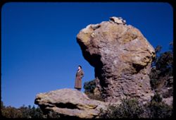
- Description:
- 25 f 13
- Subject:
- Women, Trees, Coats, Rock formations, Massai Point (Ariz.), Chiricahua National Monument (Ariz.), and National parks & reserves
- Series:
- 4-52
- Creator:
- Cushman, Charles W., 1896-1972
- Date Created:
- 1952-01-27
- Genre:
- Landscape photographs and Portraits
- Frame Number:
- 32
- County:
- Cochise
- Persons Pictured:
- Cushman, Jean
- Abstract:
- Jean on a high perch under turtle head
- Call Number:
- P05638
- Country:
- United States
- State/Province:
- Arizona
- Alternate Identifier:
- 452.32
- Persistent URL:
- http://purl.dlib.indiana.edu/iudl/archives/cushman/P05638
- Holding Location:
- Bloomington - University Archives
Wells Library E460
1320 E 10th St.
Bloomington, IN 47405
Contact at archives@indiana.edu, 812-855-1127
-
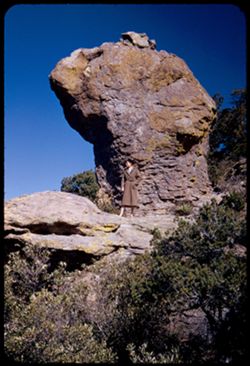
- Description:
- 25 f 13
- Subject:
- Trees, Coats, Rock formations, Massai Point (Ariz.), Chiricahua National Monument (Ariz.), and National parks & reserves
- Series:
- 4-52
- Creator:
- Cushman, Charles W., 1896-1972
- Date Created:
- 1952-01-27
- Genre:
- Landscape photographs and Portraits
- Frame Number:
- 31
- County:
- Cochise
- Persons Pictured:
- Cushman, Jean
- Abstract:
- Jean on a high perch under Turtle head
- Call Number:
- P05637
- Country:
- United States
- State/Province:
- Arizona
- Alternate Identifier:
- 452.31
- Persistent URL:
- http://purl.dlib.indiana.edu/iudl/archives/cushman/P05637
- Holding Location:
- Bloomington - University Archives
Wells Library E460
1320 E 10th St.
Bloomington, IN 47405
Contact at archives@indiana.edu, 812-855-1127
-
- Description:
- 25 f 13
- Subject:
- Trees, Mountains, Rock formations, Massai Point (Ariz.), Chiricahua National Monument (Ariz.), and National parks & reserves
- Series:
- 4-52
- Creator:
- Cushman, Charles W., 1896-1972
- Date Created:
- 1952-01-27
- Genre:
- Landscape photographs
- Frame Number:
- 30
- County:
- Cochise
- Abstract:
- View NW down into canyon
- Call Number:
- P05636
- Country:
- United States
- State/Province:
- Arizona
- Alternate Identifier:
- 452.30
- Persistent URL:
- http://purl.dlib.indiana.edu/iudl/archives/cushman/P05636
- Holding Location:
- Bloomington - University Archives
Wells Library E460
1320 E 10th St.
Bloomington, IN 47405
Contact at archives@indiana.edu, 812-855-1127
-
- Description:
- 25 f 11
- Subject:
- Valleys, Trees, Mountains, Rock formations, Massai Point (Ariz.), Chiricahua National Monument (Ariz.), and National parks & reserves
- Series:
- 4-52
- Creator:
- Cushman, Charles W., 1896-1972
- Date Created:
- 1952-01-27
- Genre:
- Landscape photographs
- Frame Number:
- 29
- County:
- Cochise
- Abstract:
- View west from trail around Massai Pt.
- Call Number:
- P05635
- Country:
- United States
- State/Province:
- Arizona
- Alternate Identifier:
- 452.29
- Persistent URL:
- http://purl.dlib.indiana.edu/iudl/archives/cushman/P05635
- Holding Location:
- Bloomington - University Archives
Wells Library E460
1320 E 10th St.
Bloomington, IN 47405
Contact at archives@indiana.edu, 812-855-1127
-
- Description:
- 25 f 13
- Subject:
- Rocks, Trees, Shrubs, Chiricahua National Monument (Ariz.), National parks & reserves, and Rock formations
- Series:
- 4-52
- Creator:
- Cushman, Charles W., 1896-1972
- Date Created:
- 1952-01-27
- Genre:
- Landscape photographs
- Frame Number:
- 28
- County:
- Cochise
- Abstract:
- Punch O Judy
- Call Number:
- P05634
- Country:
- United States
- State/Province:
- Arizona
- Alternate Identifier:
- 452.28
- Persistent URL:
- http://purl.dlib.indiana.edu/iudl/archives/cushman/P05634
- Holding Location:
- Bloomington - University Archives
Wells Library E460
1320 E 10th St.
Bloomington, IN 47405
Contact at archives@indiana.edu, 812-855-1127
-
- Description:
- 25 f 6.3 pola
- Subject:
- National parks & reserves, Valleys, Massai Point (Ariz.), Mountains, Trees, Rocks, Chiricahua National Monument (Ariz.), and Rock formations
- Series:
- 4-52
- Creator:
- Cushman, Charles W., 1896-1972
- Date Created:
- 1952-01-27
- Genre:
- Landscape photographs
- Frame Number:
- 27
- County:
- Cochise
- Abstract:
- Rocks head ? From Massai Pt.
- Call Number:
- P05633
- Country:
- United States
- State/Province:
- Arizona
- Alternate Identifier:
- 452.27
- Persistent URL:
- http://purl.dlib.indiana.edu/iudl/archives/cushman/P05633
- Holding Location:
- Bloomington - University Archives
Wells Library E460
1320 E 10th St.
Bloomington, IN 47405
Contact at archives@indiana.edu, 812-855-1127
-
- Description:
- 25 f 8 pola
- Subject:
- National parks & reserves, Massai Point (Ariz.), Mountains, Boulders, Chiricahua National Monument (Ariz.), Rock formations, and Trees
- Series:
- 4-52
- Creator:
- Cushman, Charles W., 1896-1972
- Date Created:
- 1952-01-27
- Genre:
- Landscape photographs
- Frame Number:
- 26
- County:
- Cochise
- Abstract:
- From top of Chiricahua looking NW these are from Massai PT
- Call Number:
- P05632
- Country:
- United States
- State/Province:
- Arizona
- Alternate Identifier:
- 452.26
- Persistent URL:
- http://purl.dlib.indiana.edu/iudl/archives/cushman/P05632
- Holding Location:
- Bloomington - University Archives
Wells Library E460
1320 E 10th St.
Bloomington, IN 47405
Contact at archives@indiana.edu, 812-855-1127
-
- Description:
- 25 f 6 pola
- Subject:
- Trees, Boulders, Mountains, Rock formations, Massai Point (Ariz.), Chiricahua National Monument (Ariz.), and National parks & reserves
- Series:
- 4-52
- Creator:
- Cushman, Charles W., 1896-1972
- Date Created:
- 1952-01-27
- Genre:
- Landscape photographs
- Frame Number:
- 25
- County:
- Cochise
- Abstract:
- From top of Chiricahua toward SSW
- Call Number:
- P05631
- Country:
- United States
- State/Province:
- Arizona
- Alternate Identifier:
- 452.25
- Persistent URL:
- http://purl.dlib.indiana.edu/iudl/archives/cushman/P05631
- Holding Location:
- Bloomington - University Archives
Wells Library E460
1320 E 10th St.
Bloomington, IN 47405
Contact at archives@indiana.edu, 812-855-1127
-
- Description:
- 50 f 8
- Subject:
- National parks & reserves, Cochise Head (Ariz.), Mountains, Trees, Chiricahua National Monument (Ariz.), and Rock formations
- Series:
- 4-52
- Creator:
- Cushman, Charles W., 1896-1972
- Date Created:
- 1952-01-22
- Genre:
- Landscape photographs
- Frame Number:
- 12
- County:
- Cochise
- Abstract:
- Chochise head seen from the high drive
- Call Number:
- P05618
- Country:
- United States
- State/Province:
- Arizona
- Alternate Identifier:
- 452.12
- Persistent URL:
- http://purl.dlib.indiana.edu/iudl/archives/cushman/P05618
- Holding Location:
- Bloomington - University Archives
Wells Library E460
1320 E 10th St.
Bloomington, IN 47405
Contact at archives@indiana.edu, 812-855-1127
-
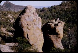
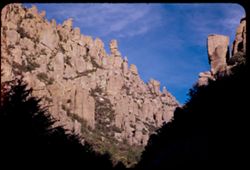
- Description:
- 25 f 9
- Subject:
- Rocks, Cliffs, Trees, Mountains, National parks & reserves, Massai Point (Ariz.), Chiricahua National Monument (Ariz.), and Rock formations
- Series:
- 4-52
- Creator:
- Cushman, Charles W., 1896-1972
- Date Created:
- 1952-01-22
- Genre:
- Landscape photographs
- Frame Number:
- 11
- County:
- Cochise
- Abstract:
- THE balanced rock (from the same wall) seen from between 2 other rocks
- Call Number:
- P05617
- Country:
- United States
- State/Province:
- Arizona
- Alternate Identifier:
- 452.11
- Persistent URL:
- http://purl.dlib.indiana.edu/iudl/archives/cushman/P05617
- Holding Location:
- Bloomington - University Archives
Wells Library E460
1320 E 10th St.
Bloomington, IN 47405
Contact at archives@indiana.edu, 812-855-1127
-
- Description:
- 25 f 13
- Subject:
- National parks & reserves, Cliffs, Massai Point (Ariz.), Trees, Rocks, Chiricahua National Monument (Ariz.), and Rock formations
- Series:
- 4-52
- Creator:
- Cushman, Charles W., 1896-1972
- Date Created:
- 1952-01-22
- Genre:
- Landscape photographs
- Frame Number:
- 10
- County:
- Cochise
- Abstract:
- Looking up at a SMALL balanced rocked
- Call Number:
- P05616
- Country:
- United States
- State/Province:
- Arizona
- Alternate Identifier:
- 452.10
- Persistent URL:
- http://purl.dlib.indiana.edu/iudl/archives/cushman/P05616
- Holding Location:
- Bloomington - University Archives
Wells Library E460
1320 E 10th St.
Bloomington, IN 47405
Contact at archives@indiana.edu, 812-855-1127
-
- Description:
- 25 f 13
- Subject:
- Rock formations, Rocks, Trees, National parks & reserves, Boulders, Chiricahua National Monument (Ariz.), and Massai Point (Ariz.)
- Series:
- 4-52
- Creator:
- Cushman, Charles W., 1896-1972
- Date Created:
- 1952-01-22
- Genre:
- Landscape photographs
- Frame Number:
- 9
- County:
- Cochise
- Abstract:
- Again the rocks at the top of the drive
- Call Number:
- P05615
- Country:
- United States
- State/Province:
- Arizona
- Alternate Identifier:
- 452.9
- Persistent URL:
- http://purl.dlib.indiana.edu/iudl/archives/cushman/P05615
- Holding Location:
- Bloomington - University Archives
Wells Library E460
1320 E 10th St.
Bloomington, IN 47405
Contact at archives@indiana.edu, 812-855-1127
-
- Description:
- 25 f 13
- Subject:
- National parks & reserves, Cliffs, Massai Point (Ariz.), Mountains, Chiricahua National Monument (Ariz.), and Rock formations
- Series:
- 4-52
- Creator:
- Cushman, Charles W., 1896-1972
- Date Created:
- 1952-01-22
- Genre:
- Landscape photographs
- Frame Number:
- 8
- County:
- Cochise
- Abstract:
- View NW from the Lookout Pt.
- Call Number:
- P05614
- Country:
- United States
- State/Province:
- Arizona
- Alternate Identifier:
- 452.8
- Persistent URL:
- http://purl.dlib.indiana.edu/iudl/archives/cushman/P05614
- Holding Location:
- Bloomington - University Archives
Wells Library E460
1320 E 10th St.
Bloomington, IN 47405
Contact at archives@indiana.edu, 812-855-1127
-
- Description:
- 25 f 13
- Subject:
- Cliffs, Tree limbs, Mountains, National parks & reserves, Massai Point (Ariz.), Chiricahua National Monument (Ariz.), Rock formations, and Clouds
- Series:
- 4-52
- Creator:
- Cushman, Charles W., 1896-1972
- Date Created:
- 1952-01-22
- Genre:
- Landscape photographs
- Frame Number:
- 7
- County:
- Cochise
- Abstract:
- View NW from the Lookout Pt.
- Call Number:
- P05613
- Country:
- United States
- State/Province:
- Arizona
- Alternate Identifier:
- 452.7
- Persistent URL:
- http://purl.dlib.indiana.edu/iudl/archives/cushman/P05613
- Holding Location:
- Bloomington - University Archives
Wells Library E460
1320 E 10th St.
Bloomington, IN 47405
Contact at archives@indiana.edu, 812-855-1127
-
- Description:
- 25 f 13
- Subject:
- National parks & reserves, Massai Point (Ariz.), Shrubs, Trees, Chiricahua National Monument (Ariz.), Rock formations, and Boulders
- Series:
- 4-52
- Creator:
- Cushman, Charles W., 1896-1972
- Date Created:
- 1952-01-22
- Genre:
- Landscape photographs
- Frame Number:
- 6
- County:
- Cochise
- Abstract:
- Rocks at top of drive-from same path down from Lookout Pt.
- Call Number:
- P05612
- Country:
- United States
- State/Province:
- Arizona
- Alternate Identifier:
- 452.6
- Persistent URL:
- http://purl.dlib.indiana.edu/iudl/archives/cushman/P05612
- Holding Location:
- Bloomington - University Archives
Wells Library E460
1320 E 10th St.
Bloomington, IN 47405
Contact at archives@indiana.edu, 812-855-1127
-
- Description:
- 25 f 13
- Subject:
- National parks & reserves, Cliffs, Massai Point (Ariz.), Boulders, Chiricahua National Monument (Ariz.), Rock formations, and Trees
- Series:
- 4-52
- Creator:
- Cushman, Charles W., 1896-1972
- Date Created:
- 1952-01-22
- Genre:
- Landscape photographs
- Frame Number:
- 5
- County:
- Cochise
- Abstract:
- View between 2 rocks near top
- Call Number:
- P05611
- Country:
- United States
- State/Province:
- Arizona
- Alternate Identifier:
- 452.5
- Persistent URL:
- http://purl.dlib.indiana.edu/iudl/archives/cushman/P05611
- Holding Location:
- Bloomington - University Archives
Wells Library E460
1320 E 10th St.
Bloomington, IN 47405
Contact at archives@indiana.edu, 812-855-1127
-
- Description:
- 50 f 9
- Subject:
- National parks & reserves, Coats, Massai Point (Ariz.), Women, Shrubs, Trees, Rocks, Trails & paths, Chiricahua National Monument (Ariz.), Rock forma...
- Series:
- 4-52
- Creator:
- Cushman, Charles W., 1896-1972
- Date Created:
- 1952-01-22
- Genre:
- Portraits and Landscape photographs
- Frame Number:
- 4
- County:
- Cochise
- Persons Pictured:
- Cushman, Jean
- Abstract:
- Jean standing at side of big rocks at top of drive up mtns. of Chiricahua Nat'l Mon. MASSAI POINT
- Call Number:
- P05610
- Country:
- United States
- State/Province:
- Arizona
- Alternate Identifier:
- 452.4
- Persistent URL:
- http://purl.dlib.indiana.edu/iudl/archives/cushman/P05610
- Holding Location:
- Bloomington - University Archives
Wells Library E460
1320 E 10th St.
Bloomington, IN 47405
Contact at archives@indiana.edu, 812-855-1127
-
- Description:
- 50 f 9
- Subject:
- National parks & reserves, Cliffs, Shrubs, Trees, Rocks, Chiricahua National Monument (Ariz.), and Rock formations
- Series:
- 4-52
- Creator:
- Cushman, Charles W., 1896-1972
- Date Created:
- 1952-01-22
- Genre:
- Landscape photographs
- Frame Number:
- 2
- County:
- Cochise
- Abstract:
- View up thru gap
- Call Number:
- P05608
- Country:
- United States
- State/Province:
- Arizona
- Alternate Identifier:
- 452.2
- Persistent URL:
- http://purl.dlib.indiana.edu/iudl/archives/cushman/P05608
- Holding Location:
- Bloomington - University Archives
Wells Library E460
1320 E 10th St.
Bloomington, IN 47405
Contact at archives@indiana.edu, 812-855-1127
-
- Description:
- 50 f 9
- Subject:
- Rocks, Trees, Boulders, National parks & reserves, Chiricahua National Monument (Ariz.), Hills, and Rock formations
- Series:
- 4-52
- Creator:
- Cushman, Charles W., 1896-1972
- Date Created:
- 1952-01-22
- Genre:
- Landscape photographs
- Frame Number:
- 3
- County:
- Cochise
- Abstract:
- Cleft rock
- Call Number:
- P05609
- Country:
- United States
- State/Province:
- Arizona
- Alternate Identifier:
- 452.3
- Persistent URL:
- http://purl.dlib.indiana.edu/iudl/archives/cushman/P05609
- Holding Location:
- Bloomington - University Archives
Wells Library E460
1320 E 10th St.
Bloomington, IN 47405
Contact at archives@indiana.edu, 812-855-1127
-
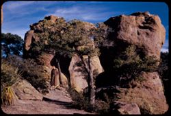
- Description:
- 25 f 11
- Subject:
- Rock formations, Trees, Chiricahua National Monument (Ariz.), Cliffs, Roads, and Shrubs
- Series:
- 3-52
- Creator:
- Cushman, Charles W., 1896-1972
- Date Created:
- 1952-01-22
- Genre:
- Landscape photographs
- Frame Number:
- 38
- County:
- Cochise
- Abstract:
- In Chiricahua National Monument
- Call Number:
- P05607
- Country:
- United States
- State/Province:
- Arizona
- Alternate Identifier:
- 352.38
- Persistent URL:
- http://purl.dlib.indiana.edu/iudl/archives/cushman/P05607
- Holding Location:
- Bloomington - University Archives
Wells Library E460
1320 E 10th St.
Bloomington, IN 47405
Contact at archives@indiana.edu, 812-855-1127
-
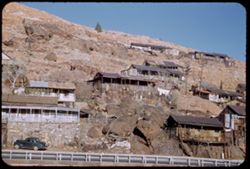
- Description:
- 25 F 9
- Subject:
- Sacramento Pit, Cities & towns, Houses, Automobiles, Cliffs, Mountains, Clotheslines, Utility poles, Electric lines, Trees, Rocks, Retaining walls, Porch...
- Series:
- 1-52
- Creator:
- Cushman, Charles W., 1896-1972
- Date Created:
- 1952-01-04
- Genre:
- Cityscape photographs and Views
- Frame Number:
- 36
- County:
- Cochise
- Abstract:
- Bisbee houses on mountainside.
- Call Number:
- P05526
- City:
- Bisbee
- Country:
- United States
- State/Province:
- Arizona
- Alternate Identifier:
- 152.36
- Persistent URL:
- http://purl.dlib.indiana.edu/iudl/archives/cushman/P05526
- Holding Location:
- Bloomington - University Archives
Wells Library E460
1320 E 10th St.
Bloomington, IN 47405
Contact at archives@indiana.edu, 812-855-1127
-
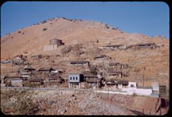
- Description:
- 25 f 11
- Subject:
- Electric lines, Houses, Streets, Mountains, Buildings, Utility poles, Water towers, Cities & towns, and People
- Series:
- 1-52
- Creator:
- Cushman, Charles W., 1896-1972
- Date Created:
- 1952-01-04
- Genre:
- Views and Cityscape photographs
- Frame Number:
- 35
- County:
- Cochise
- Abstract:
- Bisbee houses on mountainside.
- Call Number:
- P05525
- City:
- Bisbee
- Country:
- United States
- State/Province:
- Arizona
- Alternate Identifier:
- 152.35
- Persistent URL:
- http://purl.dlib.indiana.edu/iudl/archives/cushman/P05525
- Holding Location:
- Bloomington - University Archives
Wells Library E460
1320 E 10th St.
Bloomington, IN 47405
Contact at archives@indiana.edu, 812-855-1127
-
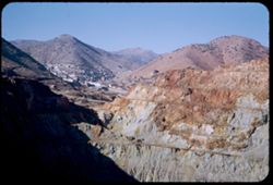
- Description:
- 25 f 11
- Subject:
- Mining, Sacramento Hill (Bisbee, Ariz.), Copper mining, Mountains, Buildings, Shrubs, and Sacramento Pit
- Series:
- 1-52
- Creator:
- Cushman, Charles W., 1896-1972
- Date Created:
- 1952-01-04
- Genre:
- Views and Cityscape photographs
- Frame Number:
- 34
- County:
- Cochise
- Abstract:
- Bisbee from top of Sacramento Pit.
- Call Number:
- P05524
- City:
- Bisbee
- Country:
- United States
- State/Province:
- Arizona
- Alternate Identifier:
- 152.34
- Persistent URL:
- http://purl.dlib.indiana.edu/iudl/archives/cushman/P05524
- Holding Location:
- Bloomington - University Archives
Wells Library E460
1320 E 10th St.
Bloomington, IN 47405
Contact at archives@indiana.edu, 812-855-1127
-
- Description:
- 25 f 11
- Subject:
- Houses, Automobiles, Sacramento Hill (Bisbee, Ariz.), Streets, Mountains, Buildings, Shrubs, Industry, Sacramento Pit, and Utility poles
- Series:
- 1-52
- Creator:
- Cushman, Charles W., 1896-1972
- Date Created:
- 1952-01-04
- Genre:
- Views and Cityscape photographs
- Frame Number:
- 33
- County:
- Cochise
- Abstract:
- Mtns. of Bisbee from Sac. Pit.
- Call Number:
- P05523
- City:
- Bisbee
- Country:
- United States
- State/Province:
- Arizona
- Alternate Identifier:
- 152.33
- Persistent URL:
- http://purl.dlib.indiana.edu/iudl/archives/cushman/P05523
- Holding Location:
- Bloomington - University Archives
Wells Library E460
1320 E 10th St.
Bloomington, IN 47405
Contact at archives@indiana.edu, 812-855-1127
-
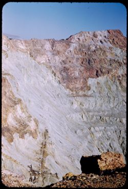
- Description:
- 25 f 11
- Subject:
- Sacramento Hill (Bisbee, Ariz.), Mining, Copper mining, Railroad tracks, Mountains, Phelps Dodge Corporation, Sacramento Pit, and Cliffs
- Series:
- 1-52
- Creator:
- Cushman, Charles W., 1896-1972
- Date Created:
- 1952-01-04
- Genre:
- Views
- Frame Number:
- 32
- County:
- Cochise
- Abstract:
- Sacramento Pit at Bisbee.
- Call Number:
- P05522
- City:
- Bisbee
- Country:
- United States
- State/Province:
- Arizona
- Alternate Identifier:
- 152.32
- Persistent URL:
- http://purl.dlib.indiana.edu/iudl/archives/cushman/P05522
- Holding Location:
- Bloomington - University Archives
Wells Library E460
1320 E 10th St.
Bloomington, IN 47405
Contact at archives@indiana.edu, 812-855-1127
-
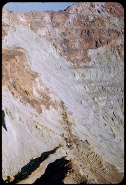
- Description:
- 25 f 11
- Subject:
- Rocks, Cliffs, Mining, Sacramento Hill (Bisbee, Ariz.), Copper mining, Mountains, Sacramento Pit, Phelps Dodge Corporation, and Railroad tracks
- Series:
- 1-52
- Creator:
- Cushman, Charles W., 1896-1972
- Date Created:
- 1952-01-04
- Genre:
- Views
- Frame Number:
- 31
- County:
- Cochise
- Abstract:
- Sacramento Pit at Bisbee.
- Call Number:
- P05521
- City:
- Bisbee
- Country:
- United States
- State/Province:
- Arizona
- Alternate Identifier:
- 152.31
- Persistent URL:
- http://purl.dlib.indiana.edu/iudl/archives/cushman/P05521
- Holding Location:
- Bloomington - University Archives
Wells Library E460
1320 E 10th St.
Bloomington, IN 47405
Contact at archives@indiana.edu, 812-855-1127
-
- Description:
- 25 f 9
- Subject:
- Buildings, Cities & towns, Mountains, Trees, Dwellings, Hotels, Streets, Copper Queen Hotel (Bisbee, Ariz.), Automobiles, Shrubs, Churches, Flagpoles, an...
- Series:
- 1-52
- Creator:
- Cushman, Charles W., 1896-1972
- Date Created:
- 1952-01-04
- Genre:
- Views and Cityscape photographs
- Frame Number:
- 30
- County:
- Cochise
- Abstract:
- from higher up. [Bisbee + Mtn from Main st.]
- Call Number:
- P05520
- City:
- Bisbee
- Country:
- United States
- State/Province:
- Arizona
- Alternate Identifier:
- 152.30
- Persistent URL:
- http://purl.dlib.indiana.edu/iudl/archives/cushman/P05520
- Holding Location:
- Bloomington - University Archives
Wells Library E460
1320 E 10th St.
Bloomington, IN 47405
Contact at archives@indiana.edu, 812-855-1127
-
- Description:
- 25 f 11
- Subject:
- Bendix Home Appliances, Inc., Elks (Fraternal order), Automobiles, Flags, Signs (Notices), Streets, Cities & towns, Buildings, Shrubs, Fraternal lodges, ...
- Series:
- 1-52
- Creator:
- Cushman, Charles W., 1896-1972
- Date Created:
- 1952-01-04
- Genre:
- Cityscape photographs
- Frame Number:
- 29
- Street Address:
- Main Street
- County:
- Cochise
- Abstract:
- Bisbee + Mtn from Main st.
- Call Number:
- P05519
- City:
- Bisbee
- Country:
- United States
- State/Province:
- Arizona
- Alternate Identifier:
- 152.29
- Persistent URL:
- http://purl.dlib.indiana.edu/iudl/archives/cushman/P05519
- Holding Location:
- Bloomington - University Archives
Wells Library E460
1320 E 10th St.
Bloomington, IN 47405
Contact at archives@indiana.edu, 812-855-1127
-
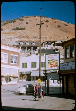
- Description:
- 25 f 11
- Subject:
- Billboards, Electric lines, Automobiles, Southern Pacific Railroad Company, Signs (Notices), Streets, Buildings, Shrubs, Dwellings, Hills, People, Cafes, and...
- Series:
- 1-52
- Creator:
- Cushman, Charles W., 1896-1972
- Date Created:
- 1952-01-04
- Genre:
- Snapshots and Cityscape photographs
- Frame Number:
- 28
- County:
- Cochise
- Abstract:
- Bisbee + Mtn from Main st.
- Call Number:
- P05518
- City:
- Bisbee
- Country:
- United States
- State/Province:
- Arizona
- Alternate Identifier:
- 152.28
- Persistent URL:
- http://purl.dlib.indiana.edu/iudl/archives/cushman/P05518
- Holding Location:
- Bloomington - University Archives
Wells Library E460
1320 E 10th St.
Bloomington, IN 47405
Contact at archives@indiana.edu, 812-855-1127
-
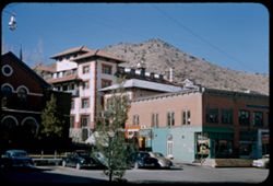
- Description:
- 25 f 9
- Subject:
- Hotels, Cities & towns, Churches, Streets, Hills, Automobiles, Street lights, Shrubs, Electric lines, Trees, Buildings, Coca-Cola Company, Signs (Notices...
- Series:
- 1-52
- Creator:
- Cushman, Charles W., 1896-1972
- Date Created:
- 1952-01-04
- Genre:
- Architectural photographs
- Frame Number:
- 27
- County:
- Cochise
- Abstract:
- Copper Queen.
- Call Number:
- P05517
- City:
- Bisbee
- Country:
- United States
- State/Province:
- Arizona
- Alternate Identifier:
- 152.27
- Persistent URL:
- http://purl.dlib.indiana.edu/iudl/archives/cushman/P05517
- Holding Location:
- Bloomington - University Archives
Wells Library E460
1320 E 10th St.
Bloomington, IN 47405
Contact at archives@indiana.edu, 812-855-1127
-
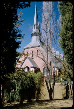
- Description:
- 25 f 9
- Subject:
- Steeples, Churches, Windows, Dormers, Gables, Shrubs, and Trees
- Series:
- 1-52
- Creator:
- Cushman, Charles W., 1896-1972
- Date Created:
- 1952-01-04
- Genre:
- Architectural photographs
- Frame Number:
- 26
- County:
- Cochise
- Abstract:
- Church at Bisbee.
- Call Number:
- P05516
- City:
- Bisbee
- Country:
- United States
- State/Province:
- Arizona
- Alternate Identifier:
- 152.26
- Persistent URL:
- http://purl.dlib.indiana.edu/iudl/archives/cushman/P05516
- Holding Location:
- Bloomington - University Archives
Wells Library E460
1320 E 10th St.
Bloomington, IN 47405
Contact at archives@indiana.edu, 812-855-1127
-
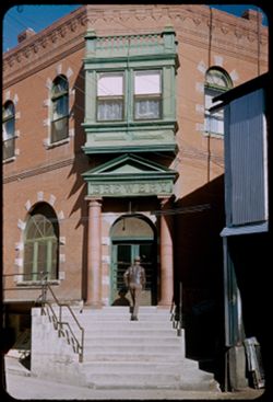
- Description:
- 25 f 9
- Subject:
- Brewing industry, Men, Brewery Gulch (Ariz.), Electric lines, Signs (Notices), Stairways, Buildings, Lintels, Copper Queen Hotel (Bisbee, Ariz.), Columns, Do...
- Series:
- 1-52
- Creator:
- Cushman, Charles W., 1896-1972
- Date Created:
- 1952-01-04
- Genre:
- Architectural photographs
- Frame Number:
- 25
- County:
- Cochise
- Abstract:
- Bisbee from vicinity of Copper Queen.
- Call Number:
- P05515
- City:
- Bisbee
- Country:
- United States
- State/Province:
- Arizona
- Alternate Identifier:
- 152.25
- Persistent URL:
- http://purl.dlib.indiana.edu/iudl/archives/cushman/P05515
- Holding Location:
- Bloomington - University Archives
Wells Library E460
1320 E 10th St.
Bloomington, IN 47405
Contact at archives@indiana.edu, 812-855-1127
-
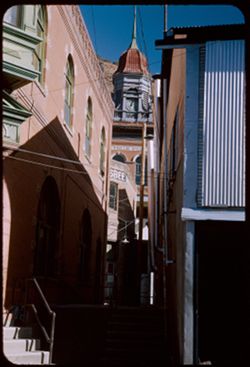
- Description:
- 25 f 9
- Subject:
- Clock towers, Spires, Copper Queen Hotel (Bisbee, Ariz.), Hills, Windows, Stairways, Utility poles, Electric lines, Buildings, Alleys, Brewery Gulch (Ariz.),...
- Series:
- 1-52
- Creator:
- Cushman, Charles W., 1896-1972
- Date Created:
- 1952-01-04
- Genre:
- Architectural photographs
- Frame Number:
- 24
- County:
- Cochise
- Abstract:
- Bisbee from vicinity of Copper Queen.
- Call Number:
- P05514
- City:
- Bisbee
- Country:
- United States
- State/Province:
- Arizona
- Alternate Identifier:
- 152.24
- Persistent URL:
- http://purl.dlib.indiana.edu/iudl/archives/cushman/P05514
- Holding Location:
- Bloomington - University Archives
Wells Library E460
1320 E 10th St.
Bloomington, IN 47405
Contact at archives@indiana.edu, 812-855-1127
-
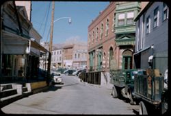
- Description:
- 50 f 8
- Subject:
- Cities & towns, Trucks, Streets, Hills, Automobiles, Street lights, Brewing industry, People, Utility poles, Electric lines, Buildings, Brewery Gulch (Ar...
- Series:
- 1-52
- Creator:
- Cushman, Charles W., 1896-1972
- Date Created:
- 1952-01-04
- Genre:
- Snapshots
- Frame Number:
- 23
- County:
- Cochise
- Abstract:
- Brewry Gulch - Bisbee.
- Call Number:
- P05513
- City:
- Bisbee
- Country:
- United States
- State/Province:
- Arizona
- Alternate Identifier:
- 152.23
- Persistent URL:
- http://purl.dlib.indiana.edu/iudl/archives/cushman/P05513
- Holding Location:
- Bloomington - University Archives
Wells Library E460
1320 E 10th St.
Bloomington, IN 47405
Contact at archives@indiana.edu, 812-855-1127
-
- Description:
- 50 f 8
- Subject:
- Dump trucks, Cliffs, Copper miners, Mining, Machinery, Copper mining, Mountains, Shrubs, Trucks, Miners, Mining equipment, and Phelps Dodge Corporation
- Series:
- 1-52
- Creator:
- Cushman, Charles W., 1896-1972
- Date Created:
- 1952-01-04
- Genre:
- Snapshots
- Frame Number:
- 22
- County:
- Cochise
- Abstract:
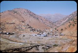
- Mining a mountainside at Lowell.
- Call Number:
- P05512
- City:
- Lowell
- Country:
- United States
- State/Province:
- Arizona
- Alternate Identifier:
- 152.22
- Persistent URL:
- http://purl.dlib.indiana.edu/iudl/archives/cushman/P05512
- Holding Location:
- Bloomington - University Archives
Wells Library E460
1320 E 10th St.
Bloomington, IN 47405
Contact at archives@indiana.edu, 812-855-1127