
Search Constraints
You searched for:
State/Province
Украинская ССР (Ukrainian Soviet Socialist Republic)
Remove constraint State/Province: Украинская ССР (Ukrainian Soviet Socialist Republic)
« Previous |
1 - 100 of 566
|
Next »
Search Results
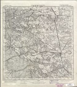
-
- Description:
- 1940
- Subject:
- Geographic Subject: Yavoriv, Topical Subject: Soviet Union, and Topical Subject: Maps
- Publisher:
- Генеральный штаб Красной Армии
- Language:
- Russian
- Date Created:
- 1944
- Identifier:
- VAC9619-003017
- Genre:
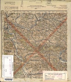
- Topographic Maps and Military Maps
- Geographic Location:
- Coordinates: 49.667, 23, 50, 23.5
- Related URL:
- Catalog URL: https://iucat.iu.edu/catalog/5020129 and Download GeoTIFF: https://drive.google.com/file/d/1HD8uB8w-zuGEnlXBdd8WK2LuwWXZ_Ryt/view?usp=sharing
- Abstract:
- Modern area represented: Yavoriv, Lviv oblast, Ukraine
- Call Number:
- G7000 s100 .S7 sheet M-34-83
- Caption:
- Для служебного пользования
- City:
- Яворов (Yavoriv)
- Copyright Holder:
- No Copyright - United States
- Country:
- СССР (USSR)
- State/Province:
- Украинская ССР (Ukrainian Soviet Socialist Republic), Дрогобычская область (Drohobych oblast), and Львовская область (Lviv oblast)
- Physical Description:
- Scale: 1:100,000
- Persistent URL:
- http://purl.dlib.indiana.edu/iudl/images/VAC9619/VAC9619-003017
- Provenance:
- DMA Topographic Center, Army Map Service Library, OMAHA
-
- Description:
- 1940
- Subject:
- Geographic Subject: Khodoriv, Topical Subject: Maps, and Topical Subject: Soviet Union
- Publisher:
- Генеральный штаб Красной Армии
- Language:
- Russian
- Date Created:
- 1944
- Identifier:
- VAC9619-003227
- Genre:
- Military Maps and Topographic Maps
- Geographic Location:
- Coordinates: 49.333, 24, 49.667, 24.5
- Related URL:
- Catalog URL: https://iucat.iu.edu/catalog/5020129 and Download GeoTIFF: https://drive.google.com/file/d/1NeXmHpFasRTqpHvTnZ3D4dmAuW4M-QUA/view?usp=sharing
- Abstract:
- Modern area represented: Khodoriv, Lviv oblast, Ukraine
- Call Number:
- G7000 s100 .S7 sheet M-35-85
- Caption:
- Для служебного пользования
- City:
- Ходоров (Khodoriv)
- Copyright Holder:
- No Copyright - United States
- Country:
- СССР (USSR)
- State/Province:
- Львовская область (Lviv oblast), Станиславская область (Stanislav oblast), Украинская ССР (Ukrainian Soviet Socialist Republic), and Дрогобычская область (Dr...
- Physical Description:
- Scale: 1:100,000
- Persistent URL:
- http://purl.dlib.indiana.edu/iudl/images/VAC9619/VAC9619-003227
- Provenance:
- DMA Topographic Center, Army Map Service Library, OMAHA, Geographic Names Branch
-
- Description:
- 1940
- Subject:
- Geographic Subject: Berezhany, Topical Subject: Soviet Union, and Topical Subject: Maps
- Publisher:
- Генеральный штаб Красной Армии
- Language:
- Russian
- Date Created:
- 1944
- Identifier:
- VAC9619-003228
- Genre:
- Topographic Maps and Military Maps
- Geographic Location:
- Coordinates: 49.333, 24.5, 49.667, 25
- Related URL:
- Catalog URL: https://iucat.iu.edu/catalog/5020129 and Download GeoTIFF: https://drive.google.com/file/d/1CMIu1hu-lpkcE8mXGG4F5QqmB7xnf-Xp/view?usp=sharing
- Abstract:
- Modern area represented: Berezhany, Ternopil oblast, Ukraine
- Call Number:
- G7000 s100 .S7 sheet M-35-86
- Caption:
- Для служебного пользования
- City:
- Бережаны (Berezhany)
- Copyright Holder:
- No Copyright - United States
- Country:
- СССР (USSR)
- State/Province:
- Тернопольская область (Ternopil oblast), Украинская ССР (Ukrainian Soviet Socialist Republic), Станиславская область (Stanislav oblast), and Львовская област...
- Physical Description:
- Scale: 1:100,000
- Persistent URL:
- http://purl.dlib.indiana.edu/iudl/images/VAC9619/VAC9619-003228
- Provenance:
- DMA Topographic Center, Army Map Service Library, OMAHA, Geographic Names Branch
-
- Description:
- 1874
- Subject:
- Topical Subject: Soviet Union, Topical Subject: Maps, and Geographic Subject: Horodok
- Publisher:
- Генеральный штаб Красной Армии
- Language:
- Russian
- Date Created:
- 1944
- Identifier:
- VAC9619-003019
- Genre:
- Military Maps and Topographic Maps
- Geographic Location:
- Coordinates: 49.667, 23.5, 50, 24
- Related URL:
- Catalog URL: https://iucat.iu.edu/catalog/5020129 and Download GeoTIFF: https://drive.google.com/file/d/1Zi3_SNdgW5DBQ3nBbEZsprfVc7U05mGs/view?usp=sharing
- Abstract:
- Modern area represented: Horodok, Lviv oblast, Ukraine
- Call Number:
- G7000 s100 .S7 sheet M-34-84
- Caption:
- Для служебного пользования
- City:
- Грудек Ягельоньски (Gródek Jagielloński)
- Copyright Holder:
- No Copyright - United States
- Country:
- СССР (USSR)
- State/Province:
- Львовская область (Lviv oblast) and Украинская ССР (Ukrainian Soviet Socialist Republic)
- Physical Description:
- Scale: 1:100,000
- Persistent URL:
- http://purl.dlib.indiana.edu/iudl/images/VAC9619/VAC9619-003019
- Provenance:
- DMA Topographic Center, Army Map Service Library, OMAHA
-
- Description:
- 1934
- Subject:
- Geographic Subject: Tomaszów Lubelski, Topical Subject: Soviet Union, and Topical Subject: Maps
- Publisher:
- Генеральный штаб Красной Армии
- Language:
- Russian
- Date Created:
- 1944
- Identifier:
- VAC9619-002859
- Genre:
- Military Maps and Topographic Maps
- Geographic Location:
- Coordinates: 50.333, 23, 50.667, 23.5
- Related URL:
- Catalog URL: https://iucat.iu.edu/catalog/5020129 and Download GeoTIFF: https://drive.google.com/file/d/1YII3rUEldUE3OnWxXVmL_97jykQAPc7O/view?usp=sharing
- Abstract:
- Modern area represented: Tomaszów Lubelski, Lublin province, Poland
- Call Number:
- G7000 s100 .S7 sheet M-34-59
- City:
- Томашув (Tomaszów)
- Copyright Holder:
- No Copyright - United States
- Country:
- СССР (USSR) and Польша (Poland)
- State/Province:
- Львовская область (Lviv oblast) and Украинская ССР (Ukrainian Soviet Socialist Republic)
- Physical Description:
- Scale: 1:100,000
- Persistent URL:
- http://purl.dlib.indiana.edu/iudl/images/VAC9619/VAC9619-002859
- Provenance:
- CIA Map Library
-

- Description:
- 1940
- Subject:
- Topical Subject: Maps, Geographic Subject: Озерна (Ozerna), and Topical Subject: Soviet Union
- Publisher:
- Генеральный штаб Красной Армии
- Language:
- Russian
- Date Created:
- 1943
- Identifier:
- VAC9619-000866
- Genre:
- Military Maps and Topographic Maps
- Geographic Location:
- Coordinates: 49.5, 25.25, 49.6667, 25.5
- Related URL:
- Download GeoTIFF: https://drive.google.com/open?id=1A_OYe8Hec_uBmt9L7Kk36TJzDvMQY32q and Catalog URL: http://iucat.iu.edu/catalog/5020131
- Abstract:
- Modern area represented: Озерна (Ozerna), Ternopil Oblast, Ukraine
- Call Number:
- G7000 s50 .S68 sheet M-35-87-B
- Caption:
- Для служебного пользования
- City:
- Езерна (Jezierna)
- Copyright Holder:
- No Copyright - United States
- Country:
- СССР (USSR)
- State/Province:
- Тарнопольская область (Tarnopolskaya oblast) and Украинская ССР (Ukrainian Soviet Socialist Republic)
- Physical Description:
- Scale: 1:50,000
- Persistent URL:
- http://purl.dlib.indiana.edu/iudl/images/VAC9619/VAC9619-000866
- Provenance:
- DMA Topographic Center, Army Map Service Library, Library of Congress Geography & Map Division
-
- Description:
- 1940
- Subject:
- Geographic Subject: Ozerna, Topical Subject: Soviet Union, and Topical Subject: Maps
- Publisher:
- Генеральный штаб Красной Армии
- Language:
- Russian
- Date Created:
- 1943
- Identifier:
- VAC9619-003229
- Genre:
- Topographic Maps and Military Maps
- Geographic Location:
- Coordinates: 49.333, 25, 49.667, 25.5
- Related URL:
- Catalog URL: https://iucat.iu.edu/catalog/5020129 and Download GeoTIFF: https://drive.google.com/file/d/1oIhAEtx39Pisvi07LTRsFECGV7AUA1t0/view?usp=sharing
- Abstract:
- Modern area represented: Ozerna, Ternopil oblast, Ukraine
- Call Number:
- G7000 s100 .S7 sheet M-35-87
- Caption:
- Для служебного пользования
- City:
- Езерна (Ozerna)
- Copyright Holder:
- No Copyright - United States
- Country:
- СССР (USSR)
- State/Province:
- Тернопольская область (Ternopil oblast) and Украинская ССР (Ukrainian Soviet Socialist Republic)
- Physical Description:
- Scale: 1:100,000
- Persistent URL:
- http://purl.dlib.indiana.edu/iudl/images/VAC9619/VAC9619-003229
- Provenance:
- DMA Topographic Center, Army Map Service Library, OMAHA
-

- Description:
- 1938
- Subject:
- Topical Subject: Soviet Union, Geographic Subject: Vesnyanka, and Topical Subject: Maps
- Publisher:
- Генеральный штаб Красной Армии
- Language:
- Russian
- Date Created:
- 1943
- Identifier:
- VAC9619-000240
- Genre:
- Topographic Maps and Military Maps
- Geographic Location:
- Coordinates: 49.667, 27.25, 49.833, 27.5
- Related URL:
- Download GeoTIFF: https://drive.google.com/open?id=1-Ai80C-v1HXb6G21Hopy4RbEUPrWv8Fa and Catalog URL: http://iucat.iu.edu/catalog/5020131
- Abstract:
- Modern area represented: Vesnyanka, Khmelnytskyi oblast, Ukraine
- Call Number:
- G7000 s50 .S68 sheet M-35-79-D
- Caption:
- Для служебного пользования
- City:
- Свинная (Svinnaya)
- Copyright Holder:
- No Copyright - United States
- Country:
- СССР (USSR)
- State/Province:
- Каменец-Подольская область (Kamianets-Podilskyi oblast) and Украинская ССР (Ukrainian Soviet Socialist Republic)
- Physical Description:
- Scale: 1:50,000
- Persistent URL:
- http://purl.dlib.indiana.edu/iudl/images/VAC9619/VAC9619-000240
- Provenance:
- M. I. Map Library, CIA Map Library, GS, RA, G000-30
-

- Description:
- 1938
- Subject:
- Topical Subject: Soviet Union, Geographic Subject: Velyki Puzyrky, and Topical Subject: Maps
- Publisher:
- Генеральный штаб Красной Армии
- Language:
- Russian
- Date Created:
- 1943
- Identifier:
- VAC9619-000234
- Genre:
- Topographic Maps and Military Maps
- Geographic Location:
- Coordinates: 49.833, 26.75, 50, 27
- Related URL:
- Catalog URL: http://iucat.iu.edu/catalog/5020131 and Download GeoTIFF: https://drive.google.com/open?id=1LsHSRQTVLwlMhEaZg9LSNN3z83Psc5lb
- Abstract:
- Modern area represented: Velyki Puzyrky, Khmelnytskyi oblast, Ukraine
- Call Number:
- G7000 s50 .S68 sheet M-35-78-B
- Caption:
- Для служебного пользования
- City:
- Большие Пузырьки (Bolshiye Puzyrki)
- Copyright Holder:
- No Copyright - United States
- Country:
- СССР (USSR)
- State/Province:
- Каменец-Подольская область (Kamianets-Podilskyi oblast) and Украинская ССР (Ukrainian Soviet Socialist Republic)
- Physical Description:
- Scale: 1:50,000
- Persistent URL:
- http://purl.dlib.indiana.edu/iudl/images/VAC9619/VAC9619-000234
- Provenance:
- CIA Map Library, G000-30, GS, RA, M. I. Map Library
-
- Description:
- 1940
- Subject:
- Topical Subject: Maps, Topical Subject: Soviet Union, and Geographic Subject: Monastyryska
- Publisher:
- Генеральный штаб Красной Армии
- Language:
- Russian
- Date Created:
- 1943
- Identifier:
- VAC9619-003241
- Genre:
- Military Maps and Topographic Maps
- Geographic Location:
- Coordinates: 49, 25, 49.333, 25.5
- Related URL:
- Catalog URL: https://iucat.iu.edu/catalog/5020129 and Download GeoTIFF: https://drive.google.com/file/d/19JTjQVmxPGwVMSR3jEaiCG8cx_31ChLG/view?usp=sharing
- Abstract:
- Modern area represented: Monastyryska, Ternopil oblast, Ukraine
- Call Number:
- G7000 s100 .S7 sheet M-35-99
- Caption:
- Для служебного пользования
- City:
- Монастыриска (Monastyryska)
- Copyright Holder:
- No Copyright - United States
- Country:
- СССР (USSR)
- State/Province:
- Тернопольская область (Ternopil oblast) and Украинская ССР (Ukrainian Soviet Socialist Republic)
- Physical Description:
- Scale: 1:100,000
- Persistent URL:
- http://purl.dlib.indiana.edu/iudl/images/VAC9619/VAC9619-003241
- Provenance:
- DMA Topographic Center, Army Map Service Library, OMAHA, Atlasblatt
-

- Description:
- 1938
- Subject:
- Topical Subject: Soviet Union, Topical Subject: Maps, and Geographic Subject: Kustivtsi
- Publisher:
- Генеральный штаб Красной Армии
- Language:
- Russian
- Date Created:
- 1943
- Identifier:
- VAC9619-000238
- Genre:
- Military Maps and Topographic Maps
- Geographic Location:
- Coordinates: 49.833, 27.25, 50, 27.5
- Related URL:
- Catalog URL: http://iucat.iu.edu/catalog/5020131 and Download GeoTIFF: https://drive.google.com/open?id=1q8ovmT_ry9lOzHTXpxTIeCE_OOlUqi3F
- Abstract:
- Modern area represented: Kustivtsi, Khmelnytskyi oblast, Ukraine
- Call Number:
- G7000 s50 .S68 sheet M-35-79-B
- Caption:
- Для служебного пользования
- City:
- Кустовцы (Kustovtsy)
- Copyright Holder:
- No Copyright - United States
- Country:
- СССР (USSR)
- State/Province:
- Каменец-Подольская область (Kamianets-Podilskyi oblast) and Украинская ССР (Ukrainian Soviet Socialist Republic)
- Physical Description:
- Scale: 1:50,000
- Persistent URL:
- http://purl.dlib.indiana.edu/iudl/images/VAC9619/VAC9619-000238
- Provenance:
- M. I. Map Library, CIA Map Library, GS, RA, G000-30
-
- Description:
- 1940
- Subject:
- Geographic Subject: Lypivka, Topical Subject: Soviet Union, and Topical Subject: Maps
- Publisher:
- Генеральный штаб Красной Армии
- Language:
- Russian
- Date Created:
- 1943
- Identifier:
- VAC9619-000861
- Genre:
- Topographic Maps and Military Maps
- Geographic Location:
- Coordinates: 49.5, 24.5, 49.6667, 24.75
- Related URL:
- Catalog URL: http://iucat.iu.edu/catalog/5020131 and Download GeoTIFF: https://drive.google.com/open?id=1ej6f12IV_QxoID6Ct29cAOhFOBjx25jZ
- Abstract:
- Modern area represented: Lypivka, Ivano-Frankivsk oblast, Ukraine
- Call Number:
- G7000 s50 .S68 sheet M-35-86-A
- Caption:
- Для служебного пользования
- City:
- Фирлеюв (Firlejów)
- Copyright Holder:
- No Copyright - United States
- Country:
- СССР (USSR)
- State/Province:
- Украинская ССР (Ukrainian Soviet Socialist Republic), Львовская область (Lviv oblast), and Станиславская область (Stanislav oblast)
- Physical Description:
- Scale: 1:50,000
- Persistent URL:
- http://purl.dlib.indiana.edu/iudl/images/VAC9619/VAC9619-000861
- Provenance:
- DMA Topographic Center, Army Map Service Library, OMAHA, Library of Congress Geography & Map Division
-
- Description:
- 1940
- Subject:
- Geographic Subject: Топорів (Toporiv), Topical Subject: Soviet Union, and Topical Subject: Maps
- Publisher:
- Генеральный штаб Красной Армии
- Language:
- Russian
- Date Created:
- 1943
- Identifier:
- VAC9619-000232
- Genre:
- Military Maps and Topographic Maps
- Geographic Location:
- Coordinates: 50, 24.5, 50.167, 24.75
- Related URL:
- Catalog URL: http://iucat.iu.edu/catalog/5020131 and Download GeoTIFF: https://drive.google.com/open?id=11_H4F-_oZ1qMdG-z0p50WUkSaNk8GuQG
- Abstract:
- Modern area represented: Топорів (Toporiv), Lviv Oblast, Ukraine
- Call Number:
- G7000 s50 .S68 sheet M-35-62-C
- Caption:
- Для служебного пользования
- City:
- Топорув (Toporów)
- Copyright Holder:
- No Copyright - United States
- Country:
- СССР (USSR)
- State/Province:
- Львовская область (Lviv oblast) and Украинская ССР (Ukrainian Soviet Socialist Republic)
- Physical Description:
- Scale: 1:50,000
- Persistent URL:
- http://purl.dlib.indiana.edu/iudl/images/VAC9619/VAC9619-000232
- Provenance:
- DMA Topographic Center, Army Map Service Library, OMAHA, Library of Congress Geography & Map Division
-
- Description:
- 1940
- Subject:
- Geographic Subject: Зборів (Zboriv), Topical Subject: Soviet Union, and Topical Subject: Maps
- Publisher:
- Генеральный штаб Красной Армии
- Language:
- Russian
- Date Created:
- 1943
- Identifier:
- VAC9619-000865
- Genre:
- Topographic Maps and Military Maps
- Geographic Location:
- Coordinates: 49.5, 25, 49.6667, 25.25
- Related URL:
- Download GeoTIFF: https://drive.google.com/open?id=13fD1e7tHpUMyXj4TivXqIviF7MYQzEX_ and Catalog URL: http://iucat.iu.edu/catalog/5020131
- Abstract:
- Modern area represented: Зборів (Zboriv), Ternopil Oblast, Ukraine
- Call Number:
- G7000 s50 .S68 sheet M-35-87-A
- Caption:
- Для служебного пользования
- City:
- Зборов (Zborov)
- Copyright Holder:
- No Copyright - United States
- Country:
- СССР (USSR)
- State/Province:
- Тарнопольская область (Tarnopolskaya oblast) and Украинская ССР (Ukrainian Soviet Socialist Republic)
- Physical Description:
- Scale: 1:50,000
- Persistent URL:
- http://purl.dlib.indiana.edu/iudl/images/VAC9619/VAC9619-000865
- Provenance:
- DMA Topographic Center, Army Map Service Library, OMAHA, Library of Congress Geography & Map Division
-
- Description:
- 1940
- Subject:
- Topical Subject: Soviet Union, Geographic Subject: Козова (Kozova), and Topical Subject: Maps
- Publisher:
- Генеральный штаб Красной Армии
- Language:
- Russian
- Date Created:
- 1943
- Identifier:
- VAC9619-000868
- Genre:
- Military Maps and Topographic Maps
- Geographic Location:
- Coordinates: 49.3333, 25, 49.5, 25.25
- Related URL:
- Catalog URL: http://iucat.iu.edu/catalog/5020131 and Download GeoTIFF: https://drive.google.com/open?id=1skCxneunMNXcHWHSDwwBXT4FAeQfONAf
- Abstract:
- Modern area represented: Козова (Kozova), Ternopil Oblast, Ukraine
- Call Number:
- G7000 s50 .S68 sheet M-35-87-C
- Caption:
- Для служебного пользования
- City:
- Козово (Kozovo)
- Copyright Holder:
- No Copyright - United States
- Country:
- СССР (USSR)
- State/Province:
- Украинская ССР (Ukrainian Soviet Socialist Republic) and Тарнопольская область (Tarnopolskaya oblast)
- Physical Description:
- Scale: 1:50,000
- Persistent URL:
- http://purl.dlib.indiana.edu/iudl/images/VAC9619/VAC9619-000868
- Provenance:
- DMA Topographic Center, Army Map Service Library, OMAHA, Library of Congress Geography & Map Division
-
- Description:
- 1940
- Subject:
- Topical Subject: Soviet Union, Geographic Subject: Бережани (Berezhany), and Topical Subject: Maps
- Publisher:
- Генеральный штаб Красной Армии
- Language:
- Russian
- Date Created:
- 1943
- Identifier:
- VAC9619-000864
- Genre:
- Military Maps and Topographic Maps
- Geographic Location:
- Coordinates: 49.3333, 24.75, 49.5, 25
- Related URL:
- Download GeoTIFF: https://drive.google.com/open?id=1bDJJmHQrRJaA1IcVeFRn6SdNn70r1-YT and Catalog URL: http://iucat.iu.edu/catalog/5020131
- Abstract:
- Modern area represented: Бережани (Berezhany), Ternopil oblast, Ukraine
- Call Number:
- G7000 s50 .S68 sheet M-35-85-D
- Caption:
- Для служебного пользования
- City:
- Бережаны (Berezhany)
- Copyright Holder:
- No Copyright - United States
- Country:
- СССР (USSR)
- State/Province:
- Тарнопольская область (Tarnopolskaya oblast), Украинская ССР (Ukrainian Soviet Socialist Republic), and Станиславская область (Stanislav oblast)
- Physical Description:
- Scale: 1:50,000
- Persistent URL:
- http://purl.dlib.indiana.edu/iudl/images/VAC9619/VAC9619-000864
- Provenance:
- DMA Topographic Center, Army Map Service Library, OMAHA, Library of Congress Geography & Map Division
-
- Description:
- 1940
- Subject:
- Geographic Subject: Микулинці (Mykulyntsi), Topical Subject: Soviet Union, and Topical Subject: Maps
- Publisher:
- Генеральный штаб Красной Армии
- Language:
- Russian
- Date Created:
- 1943
- Identifier:
- VAC9619-000871
- Genre:
- Military Maps and Topographic Maps
- Geographic Location:
- Coordinates: 49.3333, 25.5, 49.5, 25.75
- Related URL:
- Catalog URL: http://iucat.iu.edu/catalog/5020131 and Download GeoTIFF: https://drive.google.com/open?id=1SerK0z_1QGU9b_hizMRN_4FHUtTRKbq2
- Abstract:
- Modern area represented: Микулинці (Mykulyntsi), Ternopil Oblast, Ukraine
- Call Number:
- G7000 s50 .S68 sheet M-35-88-C
- Caption:
- Для служебного пользования and Captured map
- City:
- Микулинцы (Mikulintsy)
- Copyright Holder:
- No Copyright - United States
- Country:
- СССР (USSR)
- State/Province:
- Украинская ССР (Ukrainian Soviet Socialist Republic) and Тарнопольская область (Tarnopolskaya oblast)
- Physical Description:
- Scale: 1:50,000
- Persistent URL:
- http://purl.dlib.indiana.edu/iudl/images/VAC9619/VAC9619-000871
- Provenance:
- DMA Topographic Center, Army Map Service Library, Library of Congress Geography & Map Division
-

- Description:
- 1940
- Subject:
- Topical Subject: Maps, Geographic Subject: Pomoryany, and Topical Subject: Soviet Union
- Publisher:
- Генеральный штаб Красной Армии
- Language:
- Russian
- Date Created:
- 1943
- Identifier:
- VAC9619-000862
- Genre:
- Military Maps and Topographic Maps
- Geographic Location:
- Coordinates: 49.5, 24.75, 49.6667, 25
- Related URL:
- Download GeoTIFF: https://drive.google.com/open?id=1YAlEXQj2EdsWfIjnpPTNgP5oih51vx3r and Catalog URL: http://iucat.iu.edu/catalog/5020131
- Abstract:
- Modern area represented: Pomoryany, Lviv oblast, Ukraine
- Call Number:
- G7000 s50 .S68 sheet M-35-86-B
- Caption:
- Для служебного пользования
- City:
- Поморжаны (Pomorzany)
- Copyright Holder:
- No Copyright - United States
- Country:
- СССР (USSR)
- State/Province:
- Украинская ССР (Ukrainian Soviet Socialist Republic), Тарнопольская область (Tarnopolskaya oblast), and Львовская область (Lviv oblast)
- Physical Description:
- Scale: 1:50,000
- Persistent URL:
- http://purl.dlib.indiana.edu/iudl/images/VAC9619/VAC9619-000862
- Provenance:
- DMA Topographic Center, Army Map Service Library, Library of Congress Geography & Map Division
-
- Description:
- 1940
- Subject:
- Topical Subject: Soviet Union, Topical Subject: Maps, and Geographic Subject: Ternopil
- Publisher:
- Генеральный штаб Красной Армии
- Language:
- Russian
- Date Created:
- 1943
- Identifier:
- VAC9619-003231
- Genre:
- Military Maps and Topographic Maps
- Geographic Location:
- Coordinates: 49.333, 25.5, 49.667, 26
- Related URL:
- Catalog URL: https://iucat.iu.edu/catalog/5020129 and Download GeoTIFF: https://drive.google.com/file/d/1UF0sS6_kvRqvP0KEfDmT0pjC0Dixrgla/view?usp=sharing
- Abstract:
- Modern area represented: Ternopil, Ternopil oblast, Ukraine
- Call Number:
- G7000 s100 .S7 sheet M-35-88
- Caption:
- Не подлежит оглашению
- City:
- Тарнополь (Tarnopol)
- Copyright Holder:
- No Copyright - United States
- Country:
- СССР (USSR)
- State/Province:
- Тернопольская область (Ternopil oblast) and Украинская ССР (Ukrainian Soviet Socialist Republic)
- Physical Description:
- Scale: 1:100,000
- Persistent URL:
- http://purl.dlib.indiana.edu/iudl/images/VAC9619/VAC9619-003231
- Provenance:
- DMA Topographic Center, Army Map Service Library, OMAHA, Atlasblatt
-

- Description:
- 1938
- Subject:
- Geographic Subject: Kulchyny, Topical Subject: Soviet Union, and Topical Subject: Maps
- Publisher:
- Генеральный штаб Красной Армии
- Language:
- Russian
- Date Created:
- 1943
- Identifier:
- VAC9619-000236
- Genre:
- Military Maps and Topographic Maps
- Geographic Location:
- Coordinates: 49.667, 26.75.49.833, 27
- Related URL:
- Catalog URL: http://iucat.iu.edu/catalog/5020131 and Download GeoTIFF: https://drive.google.com/open?id=1AnyiZfN_YE2t8OqdqHKfgVjz7uBLJI8A
- Abstract:
- Modern area represented: Kulchyny, Khmelnytskyi oblast, Ukraine
- Call Number:
- G7000 s50 .S68 sheet M-35-78-D
- Caption:
- Для служебного пользования
- City:
- Кульчины (Kulchiny)
- Copyright Holder:
- No Copyright - United States
- Country:
- СССР (USSR)
- State/Province:
- Украинская ССР (Ukrainian Soviet Socialist Republic) and Каменец-Подольская область (Kamianets-Podilskyi oblast)
- Physical Description:
- Scale: 1:50,000
- Persistent URL:
- http://purl.dlib.indiana.edu/iudl/images/VAC9619/VAC9619-000236
- Provenance:
- M. I. Map Library, CIA Map Library, GS, RA, G000-30
-
- Description:
- 1940
- Subject:
- Topical Subject: Soviet Union, Geographic Subject: Магерів (Maheriv), and Topical Subject: Maps
- Publisher:
- Генеральный штаб Красной Армии
- Language:
- Russian
- Date Created:
- 1943
- Identifier:
- VAC9619-000175
- Genre:
- Military Maps and Topographic Maps
- Geographic Location:
- Coordinates: 50, 23.5, 50.1667, 23.75
- Related URL:
- Catalog URL: http://iucat.iu.edu/catalog/5020131 and Download GeoTIFF: https://drive.google.com/open?id=1K_LqDFGIDwl-vZiviwCS58MrP1-rg-er
- Abstract:
- Modern area represented: Магерів (Maheriv), Lviv oblast, Ukraine
- Call Number:
- G7000 s50 .S68 sheet M-34-72-C
- Caption:
- Для служебного пользования
- City:
- Магерув (Mageruv)
- Copyright Holder:
- No Copyright - United States
- Country:
- СССР (USSR)
- State/Province:
- Украинская ССР (Ukrainian Soviet Socialist Republic) and Львовская область (Lviv oblast)
- Physical Description:
- Scale: 1:50,000
- Persistent URL:
- http://purl.dlib.indiana.edu/iudl/images/VAC9619/VAC9619-000175
- Provenance:
- DMA Topographic Center, Army Map Service Library, OMAHA, Library of Congress Geography & Map Division
-

- Description:
- 1938
- Subject:
- Geographic Subject: Velyki Zozulyntsi, Topical Subject: Maps, and Topical Subject: Soviet Union
- Publisher:
- Генеральный штаб Красной Армии
- Language:
- Russian
- Date Created:
- 1943
- Identifier:
- VAC9619-000235
- Genre:
- Military Maps and Topographic Maps
- Geographic Location:
- Coordinates: 49.667, 26.5, 49.833, 26.75
- Related URL:
- Catalog URL: http://iucat.iu.edu/catalog/5020131 and Download GeoTIFF: https://drive.google.com/open?id=12XhrKDJg7Qh1_LXahG664KE82ei_-ijH
- Abstract:
- Modern area represented: Velyki Zozulyntsi, Khmelnytskyi oblast, Ukraine
- Call Number:
- G7000 s50 .S68 sheet M-35-78-C
- Caption:
- Для служебного пользования
- City:
- Большие Зозулинцы (Bolshiye Zozulintsy)
- Copyright Holder:
- No Copyright - United States
- Country:
- СССР (USSR)
- State/Province:
- Украинская ССР (Ukrainian Soviet Socialist Republic) and Каменец-Подольская область (Kamianets-Podilskyi oblast)
- Physical Description:
- Scale: 1:50,000
- Persistent URL:
- http://purl.dlib.indiana.edu/iudl/images/VAC9619/VAC9619-000235
- Provenance:
- M. I. Map Library, CIA Map Library, GS, RA, G000-30
-

- Subject:
- Geographic Subject: Bircza, Topical Subject: Soviet Union, and Topical Subject: Maps
- Publisher:
- Генеральный штаб Красной Армии
- Language:
- Russian
- Date Created:
- 1943
- Identifier:
- VAC9619-000184
- Genre:
- Military Maps and Topographic Maps
- Geographic Location:
- Coordinates: 49.6667, 22.25, 49.8333, 22.5
- Related URL:
- Download GeoTIFF: https://drive.google.com/open?id=1KQ9mMl-4WzKNSWSqYRqtFgxKC7F8DwZe and Catalog URL: http://iucat.iu.edu/catalog/5020131
- Abstract:
- Modern area represented: Bircza, Poland
- Call Number:
- G7000 s50 .S68 sheet M-34-81-D
- Caption:
- Для служебного пользования
- City:
- Бирча
- Copyright Holder:
- No Copyright - United States
- Country:
- СССР (USSR) and Польша (Poland)
- State/Province:
- Украинская ССР (Ukrainian Soviet Socialist Republic) and Дрогобычская область (Drohobych oblast)
- Physical Description:
- Scale: 1:50,000
- Persistent URL:
- http://purl.dlib.indiana.edu/iudl/images/VAC9619/VAC9619-000184
- Provenance:
- DMA Topographic Center, Army Map Service Library, Library of Congress Geography & Map Division
-
- Description:
- 1940
- Subject:
- Topical Subject: Maps, Topical Subject: Soviet Union, and Geographic Subject: Рогатин (Rohatyn)
- Publisher:
- Генеральный штаб Красной Армии
- Language:
- Russian
- Date Created:
- 1943
- Identifier:
- VAC9619-000863
- Genre:
- Topographic Maps and Military Maps
- Geographic Location:
- Coordinates: 49.3333, 24.5, 49.5, 24.75
- Related URL:
- Catalog URL: http://iucat.iu.edu/catalog/5020131 and Download GeoTIFF: https://drive.google.com/open?id=17mxtNljaUHm_unwMstjzF0DMOb7y5x0_
- Abstract:
- Modern area represented: Рогатин (Rohatyn), Ivano-Frankivsk Oblast, Ukraine
- Call Number:
- G7000 s50 .S68 sheet M-35-85-C
- Caption:
- Для служебного пользования
- City:
- Рогатин (Rogatin)
- Copyright Holder:
- No Copyright - United States
- Country:
- СССР (USSR)
- State/Province:
- Украинская ССР (Ukrainian Soviet Socialist Republic), Станиславская область (Stanislav oblast), Львовская область (Lviv oblast), and Тарнопольская область (T...
- Physical Description:
- Scale: 1:50,000
- Persistent URL:
- http://purl.dlib.indiana.edu/iudl/images/VAC9619/VAC9619-000863
- Provenance:
- DMA Topographic Center, Army Map Service Library, OMAHA, Library of Congress Geography & Map Division
-
- Description:
- 1940
- Subject:
- Geographic Subject: Тернопіль (Ternopil'), Topical Subject: Soviet Union, and Topical Subject: Maps
- Publisher:
- Генеральный штаб Красной Армии
- Language:
- Russian
- Date Created:
- 1943
- Identifier:
- VAC9619-000869
- Genre:
- Topographic Maps and Military Maps
- Geographic Location:
- Coordinates: 49.5, 25.5, 49.6667, 25.75
- Related URL:
- Download GeoTIFF: https://drive.google.com/open?id=1b59BaJ01jjxJDQSasEyKkGWROlwEXjwN and Catalog URL: http://iucat.iu.edu/catalog/5020131
- Abstract:
- Modern area represented: Тернопіль (Ternopil'), Ternopil Oblast, Ukraine
- Call Number:
- G7000 s50 .S68 sheet M-35-88-A
- Caption:
- Для служебного пользования
- City:
- Тарнополь (Tarnopol')
- Copyright Holder:
- No Copyright - United States
- Country:
- СССР (USSR)
- State/Province:
- Тарнопольская область (Tarnopolskaya oblast) and Украинская ССР (Ukrainian Soviet Socialist Republic)
- Physical Description:
- Scale: 1:50,000
- Persistent URL:
- http://purl.dlib.indiana.edu/iudl/images/VAC9619/VAC9619-000869
- Provenance:
- DMA Topographic Center, Army Map Service Library, OMAHA, Library of Congress Geography & Map Division
-
- Description:
- 1940
- Subject:
- Geographic Subject: Drohobych, Topical Subject: Maps, and Topical Subject: Soviet Union
- Publisher:
- Генеральный штаб Красной Армии
- Language:
- Russian
- Date Created:
- 1943
- Identifier:
- VAC9619-000188
- Genre:
- Military Maps and Topographic Maps
- Geographic Location:
- Coordinates: 49.3333, 23.5, 49.5, 23.75
- Related URL:
- Download GeoTIFF: https://drive.google.com/open?id=1MEqHst-PaDcmUBcopuEIqbJT1fLMiZ5i and Catalog URL: http://iucat.iu.edu/catalog/5020131
- Abstract:
- Modern area represented: Drohobych, Ukraine
- Call Number:
- G7000 s50 .S68 and zsheet M-34-96-C
- Caption:
- Для служебного пользования
- City:
- Дрогобыч (Drohobych)
- Copyright Holder:
- No Copyright - United States
- Country:
- СССР (USSR)
- State/Province:
- Дрогобычская область (Drohobych oblast) and Украинская ССР (Ukrainian Soviet Socialist Republic)
- Physical Description:
- Scale: 1:50,000
- Persistent URL:
- http://purl.dlib.indiana.edu/iudl/images/VAC9619/VAC9619-000188
- Provenance:
- DMA Topographic Center, Army Map Service Library, OMAHA, Library of Congress Geography & Map Division
-
- Subject:
- Topical Subject: Soviet Union, Geographic Subject: Dynów, and Topical Subject: Maps
- Publisher:
- Генеральный штаб Красной Армии
- Language:
- Russian
- Date Created:
- 1943
- Identifier:
- VAC9619-000183
- Genre:
- Military Maps and Topographic Maps
- Geographic Location:
- Coordinates: 49.6667, 22, 49.8333, 22.25
- Related URL:
- Download GeoTIFF: https://drive.google.com/open?id=1QEhZxZW6Eoytn5gTtbbuufDWKvYcjSuH and Catalog URL: http://iucat.iu.edu/catalog/5020131
- Abstract:
- Modern area represented: Dynów, Poland
- Call Number:
- G7000 s50 .S68 sheet M-34-81-C
- Caption:
- Для служебного пользования
- City:
- Дынув
- Copyright Holder:
- No Copyright - United States
- Country:
- СССР (USSR) and Польша (Poland)
- State/Province:
- Украинская ССР (Ukrainian Soviet Socialist Republic) and Дрогобычская область (Drohobych oblast)
- Physical Description:
- Scale: 1:50,000
- Persistent URL:
- http://purl.dlib.indiana.edu/iudl/images/VAC9619/VAC9619-000183
- Provenance:
- DMA Topographic Center, Army Map Service Library, Library of Congress Geography & Map Division
-
- Description:
- 1938
- Subject:
- Topical Subject: Maps, Topical Subject: Soviet Union, and Geographic Subject: Pidvolochysk
- Publisher:
- Генеральный штаб Красной Армии
- Language:
- Russian
- Date Created:
- 1943
- Identifier:
- VAC9619-003232
- Genre:
- Military Maps and Topographic Maps
- Geographic Location:
- Coordinates: 49.333, 26, 49.667, 26.5
- Related URL:
- Catalog URL: https://iucat.iu.edu/catalog/5020129 and Download GeoTIFF: https://drive.google.com/file/d/1oyrWK-zuKrAePV5LjJnafdKMoKrFyay8/view?usp=sharing
- Abstract:
- Modern area represented: Pidvolochysk, Ternopil oblast, Ukraine
- Call Number:
- G7000 s100 .S7 sheet M-35-89
- Caption:
- Для служебного пользования
- City:
- Подволочисск (Pidvolochysk)
- Copyright Holder:
- No Copyright - United States
- Country:
- СССР (USSR)
- State/Province:
- Украинская ССР (Ukrainian Soviet Socialist Republic), Тернопольская область (Ternopil oblast), and Каменец-Подольская область (Kamianets-Podilskyi oblast)
- Physical Description:
- Scale: 1:100,000
- Persistent URL:
- http://purl.dlib.indiana.edu/iudl/images/VAC9619/VAC9619-003232
- Provenance:
- DMA Topographic Center, Army Map Service Library, OMAHA, Geographic Names Branch
-

- Description:
- 1938
- Subject:
- Topical Subject: Maps, Topical Subject: Soviet Union, and Geographic Subject: Starokostyantyniv
- Publisher:
- Генеральный штаб Красной Армии
- Language:
- Russian
- Date Created:
- 1943
- Identifier:
- VAC9619-000239
- Genre:
- Military Maps and Topographic Maps
- Geographic Location:
- Coordinates: 49.667, 27, 49.833, 27.25
- Related URL:
- Catalog URL: http://iucat.iu.edu/catalog/5020131 and Download GeoTIFF: https://drive.google.com/open?id=1mvfhz4xba0qVIvxlATm9K_a9pOH4Ex8D
- Abstract:
- Modern area represented: Starokostyantyniv, Khmelnytskyi oblast, Ukraine
- Call Number:
- G7000 s50 .S68 sheet M-35-79-C
- Caption:
- Для служебного пользования
- City:
- Старо-Константинов (Staro-Kostantinov)
- Copyright Holder:
- No Copyright - United States
- Country:
- СССР (USSR)
- State/Province:
- Каменец-Подольская область (Kamianets-Podilskyi oblast) and Украинская ССР (Ukrainian Soviet Socialist Republic)
- Physical Description:
- Scale: 1:50,000
- Persistent URL:
- http://purl.dlib.indiana.edu/iudl/images/VAC9619/VAC9619-000239
- Provenance:
- M. I. Map Library, CIA Map Library, GS, RA, G000-30
-
- Description:
- 1940
- Subject:
- Geographic Subject: Богородчани (Bohorodchany), Topical Subject: Soviet Union, and Topical Subject: Maps
- Publisher:
- Генеральный штаб Красной Армии
- Language:
- Russian
- Date Created:
- 1943
- Identifier:
- VAC9619-000876
- Genre:
- Topographic Maps and Military Maps
- Geographic Location:
- Coordinates: 48.6667, 24.5, 48.8333, 24.75
- Related URL:
- Catalog URL: http://iucat.iu.edu/catalog/5020131 and Download GeoTIFF: https://drive.google.com/open?id=1POvzPGrgZOgvyq8sGq5xqB5nySWaNTtC
- Abstract:
- Modern area represented: Богородчани (Bohorodchany), Ivano-Frankivsk Oblast, Ukraine
- Call Number:
- G7000 s50 .S68 sheet M-35-110-C
- Caption:
- Captured map and Для служебного пользования
- City:
- Богородчаны (Bogorodchany)
- Copyright Holder:
- No Copyright - United States
- Country:
- СССР (USSR)
- State/Province:
- Украинская ССР (Ukrainian Soviet Socialist Republic) and Станиславская область (Stanislav oblast)
- Physical Description:
- Scale: 1:50,000
- Persistent URL:
- http://purl.dlib.indiana.edu/iudl/images/VAC9619/VAC9619-000876
- Provenance:
- DMA Topographic Center, Army Map Service Library, OMAHA, Library of Congress Geography & Map Division
-

- Description:
- 1938
- Subject:
- Topical Subject: Soviet Union, Topical Subject: Maps, and Geographic Subject: Bilohorodka
- Publisher:
- Генеральный штаб Красной Армии
- Language:
- Russian
- Date Created:
- 1943
- Identifier:
- VAC9619-000233
- Genre:
- Military Maps and Topographic Maps
- Geographic Location:
- Coordinates: 49.833, 26.5, 50, 26.75
- Related URL:
- Catalog URL: http://iucat.iu.edu/catalog/5020131 and Download GeoTIFF: https://drive.google.com/open?id=1D9gP3cysExxi6HZLnaYkcDpM1uFNUDTN
- Abstract:
- Modern area represented: Bilohorodka, Khmelnytskyi oblast, Ukraine
- Call Number:
- G7000 s50 .S68 sheet M-35-78-A
- Caption:
- Для служебного пользования
- City:
- Белогородка (Belogorodka)
- Copyright Holder:
- No Copyright - United States
- Country:
- СССР (USSR)
- State/Province:
- Каменец-Подольская область (Kamianets-Podilskyi oblast) and Украинская ССР (Ukrainian Soviet Socialist Republic)
- Physical Description:
- Scale: 1:50,000
- Persistent URL:
- http://purl.dlib.indiana.edu/iudl/images/VAC9619/VAC9619-000233
- Provenance:
- M. I. Map Library, CIA Map Library, GS, RA, G000-30
-
- Description:
- 1940
- Subject:
- Geographic Subject: Bibrka, Topical Subject: Maps, and Topical Subject: Soviet Union
- Publisher:
- Генеральный штаб Красной Армии
- Language:
- Russian
- Date Created:
- 1943
- Identifier:
- VAC9619-000859
- Genre:
- Military Maps and Topographic Maps
- Geographic Location:
- Coordinates: 49.5, 24.25, 49.6667, 24.5
- Related URL:
- Download GeoTIFF: https://drive.google.com/open?id=1eqi6M38V02pHwzOeN4m7iipmU-L7GebA and Catalog URL: http://iucat.iu.edu/catalog/5020131
- Abstract:
- Modern area represented: Bibrka, Lviv oblast, Ukraine
- Call Number:
- G7000 s50 .S68 sheet M-35-85-B
- Caption:
- Для служебного пользования
- City:
- Бобрка (Bobrka)
- Copyright Holder:
- No Copyright - United States
- Country:
- СССР (USSR)
- State/Province:
- Станиславская область (Stanislav oblast), Львовская область (Lviv oblast), and Украинская ССР (Ukrainian Soviet Socialist Republic)
- Physical Description:
- Scale: 1:50,000
- Persistent URL:
- http://purl.dlib.indiana.edu/iudl/images/VAC9619/VAC9619-000859
- Provenance:
- DMA Topographic Center, Army Map Service Library, Library of Congress Geography & Map Division
-
- Subject:
- Geographic Subject: Radymno, Topical Subject: Maps, and Topical Subject: Soviet Union
- Publisher:
- Генеральный штаб Красной Армии
- Language:
- Russian
- Date Created:
- 1943
- Identifier:
- VAC9619-000186
- Genre:
- Topographic Maps and Military Maps
- Geographic Location:
- Coordinates: 49.8333, 22.75, 50, 23
- Related URL:
- Download GeoTIFF: https://drive.google.com/open?id=1pqBU3q09-3jEad3cJnm_hpV3oPYNXXhm and Catalog URL: http://iucat.iu.edu/catalog/5020131
- Abstract:
- Modern area represented: Radymno, Poland
- Call Number:
- G7000 s50 .S68 sheet M-34-82-B
- Caption:
- Для служебного пользования
- City:
- Радымно (Radymno)
- Copyright Holder:
- No Copyright - United States
- Country:
- СССР (USSR) and Польша (Poland)
- State/Province:
- Украинская ССР (Ukrainian Soviet Socialist Republic), Дрогобычская область (Drohobych oblast), and Львовская область (Lviv oblast)
- Physical Description:
- Scale: 1:50,000
- Persistent URL:
- http://purl.dlib.indiana.edu/iudl/images/VAC9619/VAC9619-000186
- Provenance:
- DMA Topographic Center, Army Map Service Library, OMAHA, Library of Congress Geography & Map Division
-
- Description:
- 1940
- Subject:
- Geographic Subject: Hirske, Topical Subject: Soviet Union, and Topical Subject: Maps
- Publisher:
- Генеральный штаб Красной Армии
- Language:
- Russian
- Date Created:
- 1943
- Identifier:
- VAC9619-000189
- Genre:
- Military Maps and Topographic Maps
- Geographic Location:
- Coordinates: 49.3333, 23.75, 49.5, 24
- Related URL:
- Catalog URL: http://iucat.iu.edu/catalog/5020131 and Download GeoTIFF: https://drive.google.com/open?id=10lWgN5O-R7CViGknjll3h009WsLeDRcm
- Abstract:
- Modern area represented: Hirske, Ukraine
- Call Number:
- G7000 s50 .S68 sheet M-34-96-D
- Caption:
- Для служебного пользования
- City:
- Горуцко (Gorutsko)
- Copyright Holder:
- No Copyright - United States
- Country:
- СССР (USSR)
- State/Province:
- Дрогобычская область (Drohobych oblast) and Украинская ССР (Ukrainian Soviet Socialist Republic)
- Physical Description:
- Scale: 1:50,000
- Persistent URL:
- http://purl.dlib.indiana.edu/iudl/images/VAC9619/VAC9619-000189
- Provenance:
- DMA Topographic Center, Army Map Service Library, Library of Congress Geography & Map Division
-

- Description:
- 1938
- Subject:
- Topical Subject: Maps, Topical Subject: Soviet Union, and Geographic Subject: Hrytsiv
- Publisher:
- Генеральный штаб Красной Армии
- Language:
- Russian
- Date Created:
- 1943
- Identifier:
- VAC9619-000237
- Genre:
- Military Maps and Topographic Maps
- Geographic Location:
- Coordinates: 49.833, 27, 50, 27.25
- Related URL:
- Download GeoTIFF: https://drive.google.com/open?id=1t76bX3KXSvYcGuTJuWhEF9CmfDwbnm4_ and Catalog URL: http://iucat.iu.edu/catalog/5020131
- Abstract:
- Modern area represented: Hrytsiv, Khmelnytskyi oblast, Ukraine
- Call Number:
- G7000 s50 .S68 sheet M-35-79-A
- Caption:
- Для служебного пользования
- City:
- Грицев (Gritsev)
- Copyright Holder:
- No Copyright - United States
- Country:
- СССР (USSR)
- State/Province:
- Каменец-Подольская область (Kamianets-Podilskyi oblast) and Украинская ССР (Ukrainian Soviet Socialist Republic)
- Physical Description:
- Scale: 1:50,000
- Persistent URL:
- http://purl.dlib.indiana.edu/iudl/images/VAC9619/VAC9619-000237
- Provenance:
- M. I. Map Library, CIA Map Library, GS, RA, G000-30
-
- Description:
- 1941
- Subject:
- Topical Subject: Maps, Topical Subject: Soviet Union, and Geographic Subject: Zachepylivka
- Publisher:
- Генеральный штаб Красной Армии
- Language:
- Russian
- Date Created:
- 1942
- Identifier:
- VAC9619-001083
- Genre:
- Topographic Maps and Military Maps
- Geographic Location:
- Coordinates: 49.167, 35, 49.333, 35.25
- Related URL:
- Download GeoTIFF: https://drive.google.com/open?id=1gD8DWOnnelvXp4qj3lPQ_vYPkk8dUxa_ and Catalog URL: http://iucat.iu.edu/catalog/5020131
- Abstract:
- Modern area represented: Zachepylivka, Kharkiv oblast, Ukraine
- Call Number:
- G7000 s50 .S68 М-36-107-А
- Caption:
- Для служебного пользования
- City:
- Зачепиловка (Zachepylivka)
- Copyright Holder:
- No Copyright - United States
- Country:
- СССР (USSR)
- State/Province:
- Днепропетровская область (Dnipropetrovsk oblast), Украинская ССР (Ukrainian Soviet Socialist Republic), Харьковская область (Kharkiv oblast), and Полтавская ...
- Physical Description:
- Scale: 1:50,000
- Persistent URL:
- http://purl.dlib.indiana.edu/iudl/images/VAC9619/VAC9619-001083
- Provenance:
- DMA Topographic Center, Army Map Service Library, OMAHA, Library of Congress Geography & Map Division
-
- Subject:
- Topical Subject: Soviet Union, Topical Subject: Maps, and Geographic Subject: Melykhivka
- Publisher:
- Генеральный штаб Красной Армии
- Language:
- Russian
- Date Created:
- 1942
- Identifier:
- VAC9619-001049
- Genre:
- Topographic Maps and Military Maps
- Geographic Location:
- Coordinates: 49.5, 35.75, 49.6667, 36
- Related URL:
- Catalog URL: http://iucat.iu.edu/catalog/5020131 and Download GeoTIFF: https://drive.google.com/open?id=1U_njyIztDh7j4OtSpiutyC0dRp8k4dO7
- Abstract:
- Modern area represented: Мелихівка (Melykhivka), Kharkiv oblast, Ukraine
- Call Number:
- G7000 s50 .S68 sheet M-36-96-B
- Caption:
- Для служебного пользования
- City:
- Мелиховка (Melihovka)
- Copyright Holder:
- No Copyright - United States
- Country:
- СССР (USSR)
- State/Province:
- Украинская ССР (Ukrainian Soviet Socialist Republic) and Харьковская область (Kharkiv oblast)
- Physical Description:
- Scale: 1:50,000
- Persistent URL:
- http://purl.dlib.indiana.edu/iudl/images/VAC9619/VAC9619-001049
- Provenance:
- DMA Topographic Center, Army Map Service Library, OMAHA, Library of Congress Geography & Map Division
-
- Description:
- 1931
- Subject:
- Topical Subject: Soviet Union, Geographic Subject: Lyashkovka, and Topical Subject: Maps
- Publisher:
- Генеральный штаб Красной Армии
- Language:
- Russian
- Date Created:
- 1942
- Identifier:
- VAC9619-001076
- Genre:
- Military Maps and Topographic Maps
- Geographic Location:
- Coordinates: 49, 34.25, 49.167, 34.5
- Related URL:
- Catalog URL: http://iucat.iu.edu/catalog/5020131 and Download GeoTIFF: https://drive.google.com/open?id=1c8wly2U9bSKSzil34HedbIipq6N_4rrS
- Abstract:
- Modern area represented: Lyashkovka, Dnipropetrovsk oblast, Ukraine
- Call Number:
- G7000 s50 .S68 М-36-105-Г
- Caption:
- Для служебного пользования
- City:
- Лишковка (Lyashkovka)
- Copyright Holder:
- No Copyright - United States
- Country:
- СССР (USSR)
- State/Province:
- Полтавская область (Poltava oblast), Украинская ССР (Ukrainian Soviet Socialist Republic), and Днепропетровская область (Dnipropetrovsk oblast)
- Physical Description:
- Scale: 1:50,000
- Persistent URL:
- http://purl.dlib.indiana.edu/iudl/images/VAC9619/VAC9619-001076
- Provenance:
- DMA Topographic Center, Army Map Service Library, OMAHA, Library of Congress Geography & Map Division
-
- Description:
- 1935
- Subject:
- Topical Subject: Soviet Union, Geographic Subject: Shyroke, and Topical Subject: Maps
- Publisher:
- Генеральный штаб Красной Армии
- Language:
- Russian
- Date Created:
- 1942
- Identifier:
- VAC9619-001176
- Genre:
- Military Maps and Topographic Maps
- Geographic Location:
- Coordinates: 48, 34.75, 48.167, 35
- Related URL:
- Download GeoTIFF: https://drive.google.com/open?id=1xzNOFibbwdSPajgIDANxV2xynzmodIeL and Catalog URL: http://iucat.iu.edu/catalog/5020131
- Abstract:
- Modern area represented: Shyroke, Zaporizhia oblast, Ukraine
- Call Number:
- GM G7000 S50 .S68 M-36-142-Г
- Caption:
- Для служебного пользования
- City:
- Широкое (Shyroke)
- Copyright Holder:
- No Copyright - United States
- Country:
- СССР (USSR)
- State/Province:
- Запорожская область (Zaporizhia oblast), Украинская ССР (Ukrainian Soviet Socialist Republic), and Днепропетровская область (Dnipropetrovsk oblast)
- Physical Description:
- Scale: 1:50,000
- Persistent URL:
- http://purl.dlib.indiana.edu/iudl/images/VAC9619/VAC9619-001176
- Provenance:
- DMA Topographic Center, Army Map Service Library, OMAHA, Library of Congress Geography & Map Division
-
- Subject:
- Topical Subject: Soviet Union, Geographic Subject: Chutove, and Topical Subject: Maps
- Publisher:
- Генеральный штаб Красной Армии
- Language:
- Russian
- Date Created:
- 1942
- Identifier:
- VAC9619-001014
- Genre:
- Military Maps and Topographic Maps
- Geographic Location:
- Coordinates: 49.6667, 35, 49.8333, 35.25
- Related URL:
- Download GeoTIFF: https://drive.google.com/open?id=1K8adgo38HpOvjgBpy7OpG06QtBHlj-G1 and Catalog URL: http://iucat.iu.edu/catalog/5020131
- Abstract:
- Modern area represented: Чутове (Chutove), Poltava oblast, Ukraine
- Call Number:
- G7000 s50 .S68 sheet M-36-83-C
- Caption:
- Для служебного пользования
- City:
- Чутово (Chutovo)
- Copyright Holder:
- No Copyright - United States
- Country:
- СССР (USSR)
- State/Province:
- Харьковская область (Kharkiv oblast), Украинская ССР (Ukrainian Soviet Socialist Republic), and Полтавская область (Poltava oblast)
- Physical Description:
- Scale: 1:50,000
- Persistent URL:
- http://purl.dlib.indiana.edu/iudl/images/VAC9619/VAC9619-001014
- Provenance:
- DMA Topographic Center, Army Map Service Library, OMAHA, Library of Congress Geography & Map Division
-
- Description:
- 1931
- Subject:
- Geographic Subject: Borodayevka, Topical Subject: Soviet Union, and Topical Subject: Maps
- Publisher:
- Генеральный штаб Красной Армии
- Language:
- Russian
- Date Created:
- 1942
- Identifier:
- VAC9619-001101
- Genre:
- Topographic Maps and Military Maps
- Geographic Location:
- Coordinates: 48.6667, 34, 48.8667, 34.25
- Related URL:
- Download GeoTIFF: https://drive.google.com/open?id=1N0IyIRjTgBq351O1uGROHeHzSrRUKxUO and Catalog URL: http://iucat.iu.edu/catalog/5020131
- Abstract:
- Modern area represented: Borodayevka, Dnipropetrovsk oblast, Ukraine
- Call Number:
- G7000 s50 .S68 М-36-117-В
- Caption:
- Для служебного пользования
- City:
- Бородаевка (Borodayevka)
- Copyright Holder:
- No Copyright - United States
- Country:
- СССР (USSR)
- State/Province:
- Днепропетровская область (Dnipropetrovsk oblast), Полтавская область (Poltava oblast), and Украинская ССР (Ukrainian Soviet Socialist Republic)
- Physical Description:
- Scale: 1:50,000
- Persistent URL:
- http://purl.dlib.indiana.edu/iudl/images/VAC9619/VAC9619-001101
- Provenance:
- Library of Congress Geography & Map Division
-
- Description:
- 1930
- Subject:
- Topical Subject: Maps, Topical Subject: Soviet Union, and Geographic Subject: Velyka Lepetykha
- Publisher:
- Генеральный штаб Красной Армии
- Language:
- Russian
- Date Created:
- 1942
- Identifier:
- VAC9619-001876
- Genre:
- Topographic Maps and Military Maps
- Geographic Location:
- Coordinates: 47, 33.5, 47.3333, 34
- Related URL:
- Catalog URL: https://iucat.iu.edu/catalog/5020129 and Download GeoTIFF: https://drive.google.com/open?id=1KEO4HekmlEItJ6LWmCEklRcW04fJsr0O
- Abstract:
- Modern area represented: Velyka Lepetykha, Kherson oblast, Ukraine
- Call Number:
- G7000 s100 .S7 sheet L-36-32
- Caption:
- Для служебного пользования
- City:
- Бол. Лепатиха (Bolshaya Lepatikha)
- Copyright Holder:
- No Copyright - United States
- Country:
- СССР (USSR)
- State/Province:
- Украинская ССР (Ukrainian Soviet Socialist Republic)
- Physical Description:
- Scale: 1:100,000
- Persistent URL:
- http://purl.dlib.indiana.edu/iudl/images/VAC9619/VAC9619-001876
- Provenance:
- DMA Topographic Center, Army Map Service Library, Library of Congress Geography & Map Division
-
- Description:
- 1934
- Subject:
- Geographic Subject: Chaplinka, Topical Subject: Soviet Union, and Topical Subject: Maps
- Publisher:
- Генеральный штаб Красной Армии
- Language:
- Russian
- Date Created:
- 1942
- Identifier:
- VAC9619-001108
- Genre:
- Military Maps and Topographic Maps
- Geographic Location:
- Coordinates: 48.6667, 34.75, 48.8667, 35
- Related URL:
- Catalog URL: http://iucat.iu.edu/catalog/5020131 and Download GeoTIFF: https://drive.google.com/open?id=1IHM7B8nMtnqFFdL6WepZBUnK2XFMJiwv
- Abstract:
- Modern area represented: Chaplinka, Dnipropetrovsk oblast, Ukraine
- Call Number:
- G7000 s50 .S68 М-36-118-Г
- Caption:
- Для служебного пользования
- City:
- Чаплинка (Chaplinka)
- Copyright Holder:
- No Copyright - United States
- Country:
- СССР (USSR)
- State/Province:
- Украинская ССР (Ukrainian Soviet Socialist Republic) and Днепропетровская область (Dnipropetrovsk oblast)
- Physical Description:
- Scale: 1:50,000
- Persistent URL:
- http://purl.dlib.indiana.edu/iudl/images/VAC9619/VAC9619-001108
- Provenance:
- DMA Topographic Center, Army Map Service Library, OMAHA, Library of Congress Geography & Map Division
-
- Description:
- 1931
- Subject:
- Topical Subject: Maps, Geographic Subject: Donetsk, Geographic Subject: Kalmiuske, and Topical Subject: Soviet Union
- Publisher:
- Генеральный штаб Красной Армии
- Language:
- Russian
- Date Created:
- 1942
- Identifier:
- VAC9619-002004
- Genre:
- Topographic Maps and Military Maps
- Geographic Location:
- Coordinates: 47.3333, 39, 47.6667, 39.5
- Related URL:
- Download GeoTIFF: https://drive.google.com/open?id=1NZxwosLYVa9EAJO1rvzTEoZMt-K31pfv and Catalog URL: https://iucat.iu.edu/catalog/5020129
- Abstract:
- Modern area represented: Кальміуське (Kalmiuske), Donetsk, Ukraine
- Call Number:
- G7000 s100 .S7 sheet L-37-17
- Caption:
- Для cлужебного пользования
- City:
- Каракубстрой (Karakubstroy)
- Copyright Holder:
- No Copyright - United States
- Country:
- СССР (USSR)
- State/Province:
- Украинская ССР (Ukrainian Soviet Socialist Republic), Сталинская область (Stalino oblast), Ростовская область (Rostov oblast), and РСФСР (RSFSR)
- Physical Description:
- Scale: 1:100,000
- Persistent URL:
- http://purl.dlib.indiana.edu/iudl/images/VAC9619/VAC9619-002004
- Provenance:
- DMA Topographic Center, Army Map Service Library, OMAHA
-
- Description:
- 1941
- Subject:
- Topical Subject: Soviet Union, Geographic Subject: Holubivka, and Topical Subject: Maps
- Publisher:
- Генеральный штаб Красной Армии
- Language:
- Russian
- Date Created:
- 1942
- Identifier:
- VAC9619-001110
- Genre:
- Military Maps and Topographic Maps
- Geographic Location:
- Coordinates: 48.8667, 35.25, 49, 35.5
- Related URL:
- Download GeoTIFF: https://drive.google.com/open?id=1hUUHv3ae7EjS7juhaQ8byKj8Ha7F1QQK and Catalog URL: http://iucat.iu.edu/catalog/5020131
- Abstract:
- Modern area represented: Holubivka, Dnipropetrovsk oblast, Ukraine
- Call Number:
- G7000 s50 .S68 М-36-119-Б
- Caption:
- Для служебного пользования
- City:
- Голубовка (Holubivka)
- Copyright Holder:
- No Copyright - United States
- Country:
- СССР (USSR)
- State/Province:
- Украинская ССР (Ukrainian Soviet Socialist Republic), Днепропетровская область (Dnipropetrovsk oblast), and Харьковская область (Kharkiv oblast)
- Physical Description:
- Scale: 1:50,000
- Persistent URL:
- http://purl.dlib.indiana.edu/iudl/images/VAC9619/VAC9619-001110
- Provenance:
- DMA Topographic Center, Army Map Service Library, Library of Congress Geography & Map Division
-
- Description:
- 1933
- Subject:
- Topical Subject: Maps, Geographic Subject: Tsarychanka, and Topical Subject: Soviet Union
- Publisher:
- Генеральный штаб Красной Армии
- Language:
- Russian
- Date Created:
- 1942
- Identifier:
- VAC9619-001100
- Genre:
- Topographic Maps and Military Maps
- Geographic Location:
- Coordinates: 48.833, 34.25, 49, 34.5
- Related URL:
- Catalog URL: http://iucat.iu.edu/catalog/5020131 and Download GeoTIFF: https://drive.google.com/open?id=1AKN5c5pYBrKRWYTDUzumOorpZ74Y6L0g
- Abstract:
- Modern area represented: Tsarychanka, Dnipropetrovsk oblast, Ukraine
- Call Number:
- G7000 s50 .S68 М-36-117-Б
- Caption:
- Для служебного пользования
- City:
- Царичанка (Tsarychanka)
- Copyright Holder:
- No Copyright - United States
- Country:
- СССР (USSR)
- State/Province:
- Полтавская область (Poltava oblast), Днепропетровская область (Dnipropetrovsk oblast), and Украинская ССР (Ukrainian Soviet Socialist Republic)
- Physical Description:
- Scale: 1:50,000
- Persistent URL:
- http://purl.dlib.indiana.edu/iudl/images/VAC9619/VAC9619-001100
- Provenance:
- Library of Congress Geography & Map Division
-
- Description:
- 1933
- Subject:
- Topical Subject: Soviet Union, Geographic Subject: Kamianske, and Topical Subject: Maps
- Publisher:
- Генеральный штаб Красной Армии
- Language:
- Russian
- Date Created:
- 1942
- Identifier:
- VAC9619-001151
- Genre:
- Military Maps and Topographic Maps
- Geographic Location:
- Coordinates: 48.5, 34.5, 48.66667, 34.75
- Related URL:
- Download GeoTIFF: https://drive.google.com/open?id=1UgTvcHsZB7O5nINkPB6FTKzZgAW3bBZL and Catalog URL: http://iucat.iu.edu/catalog/5020131
- Abstract:
- Modern area represented: Kamianske, Dnipropetrovsk oblast, Ukraine
- Call Number:
- G7000 s50 .S68 sheet M-36-130-A
- Caption:
- Для служебного пользования
- City:
- Днепродзержинск (Dniprodzerzhynsk)
- Copyright Holder:
- No Copyright - United States
- Country:
- СССР (USSR)
- State/Province:
- Днепропетровская область (Dnipropetrovsk oblast) and Украинская ССР (Ukrainian Soviet Socialist Republic)
- Physical Description:
- Scale: 1:50,000
- Persistent URL:
- http://purl.dlib.indiana.edu/iudl/images/VAC9619/VAC9619-001151
- Provenance:
- DMA Topographic Center, Army Map Service Library, Library of Congress Geography & Map Division
-
- Description:
- 1934
- Subject:
- Geographic Subject: Pidhorodne, Topical Subject: Soviet Union, and Topical Subject: Maps
- Publisher:
- Генеральный штаб Красной Армии
- Language:
- Russian
- Date Created:
- 1942
- Identifier:
- VAC9619-001154
- Genre:
- Military Maps and Topographic Maps
- Geographic Location:
- Coordinates: 48.5, 35.0, 48.66667, 35.25
- Related URL:
- Catalog URL: http://iucat.iu.edu/catalog/5020131 and Download GeoTIFF: https://drive.google.com/open?id=1v2tm7FM4S2mU3E39G54ewU6RZz8syb36
- Abstract:
- Modern area represented: Pidhorodne, Dnipropetrovsk oblast, Ukraine
- Call Number:
- GM G7000 s50 .S68 M-36-131-A
- Caption:
- Для служебного пользования
- City:
- Подгородное (Pidhorodne)
- Copyright Holder:
- No Copyright - United States
- Country:
- СССР (USSR)
- State/Province:
- Днепропетровская область (Dnipropetrovsk oblast) and Украинская ССР (Ukrainian Soviet Socialist Republic)
- Physical Description:
- Scale: 1:50,000
- Persistent URL:
- http://purl.dlib.indiana.edu/iudl/images/VAC9619/VAC9619-001154
- Provenance:
- DMA Topographic Center, Army Map Service Library, OMAHA, Library of Congress Geography & Map Division
-

- Description:
- 1932
- Subject:
- Topical Subject: Maps, Geographic Subject: Gubinikha, and Topical Subject: Soviet Union
- Publisher:
- Генеральный штаб Красной Армии
- Language:
- Russian
- Date Created:
- 1942
- Identifier:
- VAC9619-001111
- Genre:
- Military Maps and Topographic Maps
- Geographic Location:
- Coordinates: 48.6667, 35.25, 48.8667, 35.5
- Related URL:
- Catalog URL: http://iucat.iu.edu/catalog/5020131 and Download GeoTIFF: https://drive.google.com/open?id=1h3CCG5vvQRaEMa6HfgkYvSl4F5rmvMtN
- Abstract:
- Modern area represented: Gubinikha, Dnipropetrovsk oblast, Ukraine
- Call Number:
- G7000 s50 .S68 М-36-119-Г
- Caption:
- Для служебного пользования
- City:
- Губиниха (Gubinikha)
- Copyright Holder:
- No Copyright - United States
- Country:
- СССР (USSR)
- State/Province:
- Украинская ССР (Ukrainian Soviet Socialist Republic) and Днепропетровская область (Dnipropetrovsk oblast)
- Physical Description:
- Scale: 1:50,000
- Persistent URL:
- http://purl.dlib.indiana.edu/iudl/images/VAC9619/VAC9619-001111
- Provenance:
- DMA Topographic Center, Army Map Service Library, Library of Congress Geography & Map Division
-
- Subject:
- Topical Subject: Maps, Topical Subject: Soviet Union, and Geographic Subject: Mashivka
- Publisher:
- Генеральный штаб Красной Армии
- Language:
- Russian
- Date Created:
- 1942
- Identifier:
- VAC9619-001046
- Genre:
- Military Maps and Topographic Maps
- Geographic Location:
- Coordinates: 49.3333, 34.75, 49.5, 35
- Related URL:
- Download GeoTIFF: https://drive.google.com/open?id=1i-uHI6R1mMnFbnpYUSaDwJ1FBl5QSEwF and Catalog URL: http://iucat.iu.edu/catalog/5020131
- Abstract:
- Modern area represented: Машівка (Mashivka), Poltava oblast, Ukraine
- Call Number:
- G7000 s50 .S68 sheet M-36-90-D
- Caption:
- Для служебного пользования
- City:
- Машевка (Mashevka)
- Copyright Holder:
- No Copyright - United States
- Country:
- СССР (USSR)
- State/Province:
- Украинская ССР (Ukrainian Soviet Socialist Republic) and Полтавская область (Poltava oblast)
- Physical Description:
- Scale: 1:50,000
- Persistent URL:
- http://purl.dlib.indiana.edu/iudl/images/VAC9619/VAC9619-001046
- Provenance:
- DMA Topographic Center, Army Map Service Library, OMAHA, Library of Congress Geography & Map Division
-
- Description:
- 1941
- Subject:
- Topical Subject: Soviet Union, Topical Subject: Maps, and Geographic Subject: Zhdanivka
- Publisher:
- Генеральный штаб Красной Армии
- Language:
- Russian
- Date Created:
- 1942
- Identifier:
- VAC9619-001109
- Genre:
- Military Maps and Topographic Maps
- Geographic Location:
- Coordinates: 48.8667, 35, 49, 35.25
- Related URL:
- Catalog URL: http://iucat.iu.edu/catalog/5020131 and Download GeoTIFF: https://drive.google.com/open?id=1Yw5GgUCxLBSa45iBdudYIqGSyQ8O5sV9
- Abstract:
- Modern area represented: Zhdanivka, Dnipropetrovsk oblast, Ukraine
- Call Number:
- G7000 s50 .S68 М-36-119-А
- Caption:
- Для служебного пользования
- City:
- Ждановка (Zhdanivka)
- Copyright Holder:
- No Copyright - United States
- Country:
- СССР (USSR)
- State/Province:
- Днепропетровская область (Dnipropetrovsk oblast) and Украинская ССР (Ukrainian Soviet Socialist Republic)
- Physical Description:
- Scale: 1:50,000
- Persistent URL:
- http://purl.dlib.indiana.edu/iudl/images/VAC9619/VAC9619-001109
- Provenance:
- DMA Topographic Center, Army Map Service Library, Library of Congress Geography & Map Division
-
- Description:
- 1941
- Subject:
- Topical Subject: Maps, Geographic Subject: Berestoven'ka, and Topical Subject: Soviet Union
- Publisher:
- Генеральный штаб Красной Армии
- Language:
- Russian
- Date Created:
- 1942
- Identifier:
- VAC9619-001050
- Genre:
- Military Maps and Topographic Maps
- Geographic Location:
- Coordinates: 49.3333, 35.5, 49.5, 35.75
- Related URL:
- Catalog URL: http://iucat.iu.edu/catalog/5020131 and Download GeoTIFF: https://drive.google.com/open?id=1RLSdGY0_GrzBYsmtvle-MCO1uyYsp5dK
- Abstract:
- Modern area represented: Берестовенька (Berestoven'ka), Kharkiv oblast, Ukraine
- Call Number:
- G7000 s50 .S68 sheet M-36-96-C
- Caption:
- Для служебного пользования
- City:
- Берестовенька (Berestoven'ka)
- Copyright Holder:
- No Copyright - United States
- Country:
- СССР (USSR)
- State/Province:
- Харьковская область (Kharkiv oblast) and Украинская ССР (Ukrainian Soviet Socialist Republic)
- Physical Description:
- Scale: 1:50,000
- Persistent URL:
- http://purl.dlib.indiana.edu/iudl/images/VAC9619/VAC9619-001050
- Provenance:
- DMA Topographic Center, Army Map Service Library, OMAHA, Library of Congress Geography & Map Division
-
- Description:
- 1931
- Subject:
- Geographic Subject: Kyshenky, Topical Subject: Maps, and Topical Subject: Soviet Union
- Publisher:
- Генеральный штаб Красной Армии
- Language:
- Russian
- Date Created:
- 1942
- Identifier:
- VAC9619-001099
- Genre:
- Topographic Maps and Military Maps
- Geographic Location:
- Coordinates: 48.833, 34, 49, 34.25
- Related URL:
- Catalog URL: http://iucat.iu.edu/catalog/5020131 and Download GeoTIFF: https://drive.google.com/open?id=1dNRbHY-iNZtB427mmftmyR6eRSOZLG4v
- Abstract:
- Modern area represented: Kyshenky, Poltava oblast, Ukraine
- Call Number:
- G7000 s50 .S68 М-36-117-А
- Caption:
- Для служебного пользования
- City:
- Лев. Кишеньки (Levie Kyshenky)
- Copyright Holder:
- No Copyright - United States
- Country:
- СССР (USSR)
- State/Province:
- Украинская ССР (Ukrainian Soviet Socialist Republic), Днепропетровская область (Dnipropetrovsk oblast), and Полтавская область (Poltava oblast)
- Physical Description:
- Scale: 1:50,000
- Persistent URL:
- http://purl.dlib.indiana.edu/iudl/images/VAC9619/VAC9619-001099
- Provenance:
- DMA Topographic Center, Army Map Service Library, Library of Congress Geography & Map Division
-
- Description:
- 1935
- Subject:
- Topical Subject: Soviet Union, Topical Subject: Maps, and Geographic Subject: Krinichki
- Publisher:
- Генеральный штаб Красной Армии
- Language:
- Russian
- Date Created:
- 1942
- Identifier:
- VAC9619-001150
- Genre:
- Topographic Maps and Military Maps
- Geographic Location:
- Coordinates: 48.3333, 34.25, 48.5, 34.5
- Related URL:
- Download GeoTIFF: https://drive.google.com/open?id=1b30unFXarKZF4Ewo37t6RclQfdeT2Vyn and Catalog URL: http://iucat.iu.edu/catalog/5020131
- Abstract:
- Modern area represented: Krinichki, Minsk oblast, Belarus
- Call Number:
- G7000 s50 .S68 sheet M-36-129-Г
- Caption:
- Для служебного пользования
- City:
- Кринички (Krinichki)
- Copyright Holder:
- No Copyright - United States
- Country:
- СССР (USSR)
- State/Province:
- Украинская ССР (Ukrainian Soviet Socialist Republic) and Днепропетровская область (Dnipropetrovsk oblast)
- Physical Description:
- Scale: 1:50,000
- Persistent URL:
- http://purl.dlib.indiana.edu/iudl/images/VAC9619/VAC9619-001150
- Provenance:
- DMA Topographic Center, Army Map Service Library, OMAHA, Library of Congress Geography & Map Division, Geographic Names Branch
-
- Description:
- 1940
- Subject:
- Topical Subject: Maps, Topical Subject: Soviet Union, and Geographic Subject: Peredmistne
- Publisher:
- Генеральный штаб Красной Армии
- Language:
- Russian
- Date Created:
- 1942
- Identifier:
- VAC9619-000123
- Genre:
- Topographic Maps and Military Maps
- Geographic Location:
- Coordinates: 45.8333, 34.5, 46, 34.75
- Related URL:
- https://drive.google.com/open?id=10x2abEgI_sYvWJWaepRIpxG5c1jbwXZ_, Catalog URL: http://iucat.iu.edu/catalog/5020131, and Download GeoTIFF: https://drive.goo...
- Abstract:
- Modern area represented: Peredmistne, Republic of Crimea, Ukraine
- Call Number:
- G7000 s50 .S68 sheet L-36-82-A
- Caption:
- Для служебного пользования
- City:
- Тюп-Джанкой (Tyup-Dzhankoy)
- Copyright Holder:
- No Copyright - United States
- Country:
- СССР (USSR)
- State/Province:
- Запорожская область (Zaporizhia oblast), Украинская ССР (Ukrainian Soviet Socialist Republic), Крымская АССР (Crimean Autonomous Soviet Socialist Republic), ...
- Physical Description:
- Scale: 1:50,000
- Persistent URL:
- http://purl.dlib.indiana.edu/iudl/images/VAC9619/VAC9619-000123
- Provenance:
- DMA Topographic Center, Army Map Service Library, OMAHA, Library of Congress Geography & Map Division
-
- Description:
- 1929
- Subject:
- Geographic Subject: Voloske, Topical Subject: Maps, and Topical Subject: Soviet Union
- Publisher:
- Генеральный штаб Красной Армии
- Language:
- Russian
- Date Created:
- 1942
- Identifier:
- VAC9619-001177
- Genre:
- Topographic Maps and Military Maps
- Geographic Location:
- Coordinates: 48.167, 35, 48.333, 35.25
- Related URL:
- Catalog URL: http://iucat.iu.edu/catalog/5020131 and Download GeoTIFF: https://drive.google.com/open?id=1aNeOW3iectMAu0-StBYV_VFV2WGYaU6i
- Abstract:
- Modern area represented: Voloske, Dnipropetrovsk oblast, Ukraine
- Call Number:
- GM G7000 S50 .S68 M-36-143-A
- Caption:
- Для служебного пользования
- City:
- Волоское (Voloskoye)
- Copyright Holder:
- No Copyright - United States
- Country:
- СССР (USSR)
- State/Province:
- Украинская ССР (Ukrainian Soviet Socialist Republic) and Днепропетровская область (Dnipropetrovsk oblast)
- Physical Description:
- Scale: 1:50,000
- Persistent URL:
- http://purl.dlib.indiana.edu/iudl/images/VAC9619/VAC9619-001177
- Provenance:
- DMA Topographic Center, Army Map Service Library, OMAHA, Library of Congress Geography & Map Division
-
- Description:
- 1941
- Subject:
- Geographic Subject: Starovirivka, Topical Subject: Maps, and Topical Subject: Soviet Union
- Publisher:
- Генеральный штаб Красной Армии
- Language:
- Russian
- Date Created:
- 1942
- Identifier:
- VAC9619-001048
- Genre:
- Military Maps and Topographic Maps
- Geographic Location:
- Coordinates: 49.5, 35.5, 49.6667, 35.75
- Related URL:
- Catalog URL: http://iucat.iu.edu/catalog/5020131 and Download GeoTIFF: https://drive.google.com/open?id=1epkymOh-z8QLb51mw2YoiN9UQy5BPi81
- Abstract:
- Modern area represented: Старовірівка (Starovirivka), Kharkiv oblast, Ukraine
- Call Number:
- G7000 s50 .S68 sheet M-36-96-A
- Caption:
- Для служебного пользования
- City:
- Староверовка (Staroverovka)
- Copyright Holder:
- No Copyright - United States
- Country:
- СССР (USSR)
- State/Province:
- Украинская ССР (Ukrainian Soviet Socialist Republic) and Харьковская область (Kharkiv oblast)
- Physical Description:
- Scale: 1:50,000
- Persistent URL:
- http://purl.dlib.indiana.edu/iudl/images/VAC9619/VAC9619-001048
- Provenance:
- DMA Topographic Center, Army Map Service Library, OMAHA, Library of Congress Geography & Map Division
-
- Description:
- 1941
- Subject:
- Geographic Subject: Kotovka, Topical Subject: Maps, and Topical Subject: Soviet Union
- Publisher:
- Генеральный штаб Красной Армии
- Language:
- Russian
- Date Created:
- 1942
- Identifier:
- VAC9619-001080
- Genre:
- Topographic Maps and Military Maps
- Geographic Location:
- Coordinates: 49, 34.75, 49.167, 35
- Related URL:
- Download GeoTIFF: https://drive.google.com/open?id=1OazIpWtAvrXaQNOO_-nSmWeWbVbqmOax and Catalog URL: http://iucat.iu.edu/catalog/5020131
- Abstract:
- Modern area represented: Kotovka, Dnipropetrovsk oblast, Ukraine
- Call Number:
- G7000 s50 .S68 М-36-106-Г
- Caption:
- Для служебного пользования
- City:
- Котовка (Kotovka)
- Copyright Holder:
- No Copyright - United States
- Country:
- СССР (USSR)
- State/Province:
- Полтавская область (Poltava oblast), Днепропетровская область (Dnipropetrovsk oblast), and Украинская ССР (Ukrainian Soviet Socialist Republic)
- Physical Description:
- Scale: 1:50,000
- Persistent URL:
- http://purl.dlib.indiana.edu/iudl/images/VAC9619/VAC9619-001080
- Provenance:
- DMA Topographic Center, Army Map Service Library, Library of Congress Geography & Map Division
-
- Description:
- 1933
- Subject:
- Topical Subject: Soviet Union, Geographic Subject: Verkhivtseve, and Topical Subject: Maps
- Publisher:
- Генеральный штаб Красной Армии
- Language:
- Russian
- Date Created:
- 1942
- Identifier:
- VAC9619-001149
- Genre:
- Topographic Maps and Military Maps
- Geographic Location:
- Coordinates: 48.3333, 34.0, 48.5, 34.25
- Related URL:
- Download GeoTIFF: https://drive.google.com/open?id=1r9geEKlWPN4Qcvjg6hvTYdKd7m4d3VXx and Catalog URL: http://iucat.iu.edu/catalog/5020131
- Abstract:
- Modern area represented: Verkhivtseve, Dnipropetrovsk oblast, Ukraine
- Call Number:
- G7000 s50 .S68 sheet M-36-129-B
- Caption:
- Для служебного пользования
- City:
- Верховцево (Verkhivtseve)
- Copyright Holder:
- No Copyright - United States
- Country:
- СССР (USSR)
- State/Province:
- Украинская ССР (Ukrainian Soviet Socialist Republic) and Днепропетровская область (Dnipropetrovsk oblast)
- Physical Description:
- Scale: 1:50,000
- Persistent URL:
- http://purl.dlib.indiana.edu/iudl/images/VAC9619/VAC9619-001149
- Provenance:
- DMA Topographic Center, Army Map Service Library, OMAHA, Library of Congress Geography & Map Division
-
- Subject:
- Topical Subject: Maps, Topical Subject: Soviet Union, and Geographic Subject: Novi Sanzhary
- Publisher:
- Генеральный штаб Красной Армии
- Language:
- Russian
- Date Created:
- 1942
- Identifier:
- VAC9619-001042
- Genre:
- Military Maps and Topographic Maps
- Geographic Location:
- Coordinates: 49.3333, 34.25, 49.5, 34.5
- Related URL:
- Download GeoTIFF: https://drive.google.com/open?id=1dSVe_KHHuw0RagCOmihgtm__ZT7JFBUf and Catalog URL: http://iucat.iu.edu/catalog/5020131
- Abstract:
- Modern area represented: Novi Sanzhary, Poltava oblast, Ukraine
- Call Number:
- G7000 s50 .S68 sheet M-36-93-D
- Caption:
- Для служебного пользования
- City:
- Новые Сенжары (Novye Senzhary)
- Copyright Holder:
- No Copyright - United States
- Country:
- СССР (USSR)
- State/Province:
- Украинская ССР (Ukrainian Soviet Socialist Republic) and Полтавская область (Poltava oblast)
- Physical Description:
- Scale: 1:50,000
- Persistent URL:
- http://purl.dlib.indiana.edu/iudl/images/VAC9619/VAC9619-001042
- Provenance:
- DMA Topographic Center, Army Map Service Library, OMAHA, Library of Congress Geography & Map Division
-
- Description:
- 1941
- Subject:
- Topical Subject: Maps, Topical Subject: Soviet Union, and Geographic Subject: Synelnykove
- Publisher:
- Генеральный штаб Красной Армии
- Language:
- Russian
- Date Created:
- 1942
- Identifier:
- VAC9619-001178
- Genre:
- Topographic Maps and Military Maps
- Geographic Location:
- Coordinates: 48.167, 35.5, 48.333, 35.75
- Related URL:
- Catalog URL: http://iucat.iu.edu/catalog/5020131 and Download GeoTIFF: https://drive.google.com/open?id=141GQBeT867kM5Hyrxidt4kJ5m8NmXyy_
- Abstract:
- Modern area represented: Synelnykove, Dnipropetrovsk oblast, Ukraine
- Call Number:
- GM G7000 S50 .S68 M-36-144-A
- Caption:
- Для служебного пользования
- City:
- Синельниково (Synelnykove)
- Copyright Holder:
- No Copyright - United States
- Country:
- СССР (USSR)
- State/Province:
- Днепропетровская область (Dnipropetrovsk oblast) and Украинская ССР (Ukrainian Soviet Socialist Republic)
- Physical Description:
- Scale: 1:50,000
- Persistent URL:
- http://purl.dlib.indiana.edu/iudl/images/VAC9619/VAC9619-001178
- Provenance:
- DMA Topographic Center, Army Map Service Library, Library of Congress Geography & Map Division
-
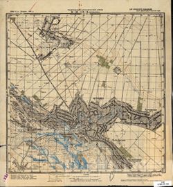
- Description:
- 1934
- Subject:
- Topical Subject: Soviet Union, Geographic Subject: Petrykivka, and Topical Subject: Maps
- Publisher:
- Генеральный штаб Красной Армии
- Language:
- Russian
- Date Created:
- 1942
- Identifier:
- VAC9619-001107
- Genre:
- Topographic Maps and Military Maps
- Geographic Location:
- Coordinates: 48.6667, 34.5, 48.8667, 34.75
- Related URL:
- Download GeoTIFF: https://drive.google.com/open?id=1DnqcNWZ8yJ3J72XuwTGa8pHQXOUKMYHq and Catalog URL: http://iucat.iu.edu/catalog/5020131
- Abstract:
- Modern area represented: Petrykivka, Dnipropetrovsk oblast, Ukraine
- Call Number:
- G7000 s50 .S68 М-36-118-В
- Caption:
- Для служебного пользования
- City:
- Петриковка (Petrykivka)
- Copyright Holder:
- No Copyright - United States
- Country:
- СССР (USSR)
- State/Province:
- Днепропетровская область (Dnipropetrovsk oblast) and Украинская ССР (Ukrainian Soviet Socialist Republic)
- Physical Description:
- Scale: 1:50,000
- Persistent URL:
- http://purl.dlib.indiana.edu/iudl/images/VAC9619/VAC9619-001107
-
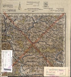
- Description:
- 1931
- Subject:
- Geographic Subject: Shulhivka, Topical Subject: Soviet Union, and Topical Subject: Maps
- Publisher:
- Генеральный штаб Красной Армии
- Language:
- Russian
- Date Created:
- 1942
- Identifier:
- VAC9619-001102
- Genre:
- Topographic Maps and Military Maps
- Geographic Location:
- Coordinates: 48.6667, 34.25, 48.8667, 34.5
- Related URL:
- Download GeoTIFF: https://drive.google.com/open?id=1tzeyi1y1acnlHWO1pb7jchsyXg_CnxKE and Catalog URL: http://iucat.iu.edu/catalog/5020131
- Abstract:
- Modern area represented: Shulhivka, Dnipropetrovsk oblast, Ukraine
- Call Number:
- G7000 s50 .S68 М-36-117-Г
- Caption:
- Для служебного пользования
- City:
- Шульговка (Shulhivka)
- Copyright Holder:
- No Copyright - United States
- Country:
- СССР (USSR)
- State/Province:
- Полтавская область (Poltava oblast), Днепропетровская область (Dnipropetrovsk oblast), and Украинская ССР (Ukrainian Soviet Socialist Republic)
- Physical Description:
- Scale: 1:50,000
- Persistent URL:
- http://purl.dlib.indiana.edu/iudl/images/VAC9619/VAC9619-001102
- Provenance:
- Library of Congress Geography & Map Division
-
- Description:
- 1932
- Subject:
- Topical Subject: Maps, Geographic Subject: Dnipro, and Topical Subject: Soviet Union
- Publisher:
- Генеральный штаб Красной Армии
- Language:
- Russian
- Date Created:
- 1942
- Identifier:
- VAC9619-001156
- Genre:
- Military Maps and Topographic Maps
- Geographic Location:
- Coordinates: 48.3333, 35.0, 48.5, 35.25
- Related URL:
- Catalog URL: http://iucat.iu.edu/catalog/5020131 and Download GeoTIFF: https://drive.google.com/open?id=1dWgz3X9ZxGf_9kO9qxqi_gtuwHW02t6r
- Abstract:
- Modern area represented: Dnipro, Dnipropetrovsk oblast, Ukraine
- Call Number:
- GM G7000 s50 .S68 M-36-131-B
- Caption:
- Для служебного пользования
- City:
- Днепропетровск (Dnipropetrovsk)
- Copyright Holder:
- No Copyright - United States
- Country:
- СССР (USSR)
- State/Province:
- Днепропетровская область (Dnipropetrovsk oblast) and Украинская ССР (Ukrainian Soviet Socialist Republic)
- Physical Description:
- Scale: 1:50,000
- Persistent URL:
- http://purl.dlib.indiana.edu/iudl/images/VAC9619/VAC9619-001156
- Provenance:
- DMA Topographic Center, Army Map Service Library, Library of Congress Geography & Map Division
-
- Description:
- 1935
- Subject:
- Geographic Subject: Novopokrovka, Topical Subject: Maps, and Topical Subject: Soviet Union
- Publisher:
- Генеральный штаб Красной Армии
- Language:
- Russian
- Date Created:
- 1942
- Identifier:
- VAC9619-001175
- Genre:
- Military Maps and Topographic Maps
- Geographic Location:
- Coordinates: 48, 34.5, 48.167, 34.75
- Related URL:
- Download GeoTIFF: https://drive.google.com/open?id=1uIRCkIch9TufzPrCHo7_ltkPZ9th3O36 and Catalog URL: http://iucat.iu.edu/catalog/5020131
- Abstract:
- Modern area represented: Novopokrovka, Dnipropetrovsk oblast, Ukraine
- Call Number:
- GM G7000 S50 .S68 M-36-142-C
- Caption:
- Для служебного пользования
- City:
- Новопокровское (Novopokrovskoe)
- Copyright Holder:
- No Copyright - United States
- Country:
- СССР (USSR)
- State/Province:
- Украинская ССР (Ukrainian Soviet Socialist Republic) and Днепропетровская область (Dnipropetrovsk oblast)
- Physical Description:
- Scale: 1:50,000
- Persistent URL:
- http://purl.dlib.indiana.edu/iudl/images/VAC9619/VAC9619-001175
- Provenance:
- DMA Topographic Center, Army Map Service Library, Library of Congress Geography & Map Division
-
- Description:
- 1932
- Subject:
- Geographic Subject: Chernyavshchyna, Topical Subject: Maps, and Topical Subject: Soviet Union
- Publisher:
- Генеральный штаб Красной Армии
- Language:
- Russian
- Date Created:
- 1942
- Identifier:
- VAC9619-001112
- Genre:
- Military Maps and Topographic Maps
- Geographic Location:
- Coordinates: 48.8667, 35.75, 49, 36
- Related URL:
- Catalog URL: http://iucat.iu.edu/catalog/5020131 and Download GeoTIFF: https://drive.google.com/open?id=1JkOS0mnfy-e0kpCBAlPFomiE177p6a8e
- Abstract:
- Modern area represented: Chernyavshchyna, Dnipropetrovsk oblast, Ukraine
- Call Number:
- G7000 s50 .S68 М-36-120-Б
- Caption:
- Для служебного пользования
- City:
- Чернявщино (Chernyavshchyna)
- Copyright Holder:
- No Copyright - United States
- Country:
- СССР (USSR)
- State/Province:
- Харьковская область (Kharkiv oblast), Украинская ССР (Ukrainian Soviet Socialist Republic), and Днепропетровская область (Dnipropetrovsk oblast)
- Physical Description:
- Scale: 1:50,000
- Persistent URL:
- http://purl.dlib.indiana.edu/iudl/images/VAC9619/VAC9619-001112
- Provenance:
- DMA Topographic Center, Army Map Service Library, Library of Congress Geography & Map Division
-
- Description:
- 1932
- Subject:
- Geographic Subject: Novomoskovsk, Topical Subject: Soviet Union, and Topical Subject: Maps
- Publisher:
- Генеральный штаб Красной Армии
- Language:
- Russian
- Date Created:
- 1942
- Identifier:
- VAC9619-001155
- Genre:
- Military Maps and Topographic Maps
- Geographic Location:
- Coordinates: 48.5, 35.25, 48.66667, 35.5
- Related URL:
- Download GeoTIFF: https://drive.google.com/open?id=1fz5hTj-wggXnOzOHbHA_Qs2ol5SjSXoR and Catalog URL: http://iucat.iu.edu/catalog/5020131
- Abstract:
- Modern area represented: Novomoskovsk, Dnipropetrovsk oblast, Ukraine
- Call Number:
- GM G7000 s50 .S68 M-36-131-Б
- Caption:
- Для служебного пользования
- City:
- Ново-Московск (Novo-Moskovsk)
- Copyright Holder:
- No Copyright - United States
- Country:
- СССР (USSR)
- State/Province:
- Днепропетровская область (Dnipropetrovsk oblast) and Украинская ССР (Ukrainian Soviet Socialist Republic)
- Physical Description:
- Scale: 1:50,000
- Persistent URL:
- http://purl.dlib.indiana.edu/iudl/images/VAC9619/VAC9619-001155
- Provenance:
- DMA Topographic Center, Army Map Service Library, Library of Congress Geography & Map Division
-
- Description:
- 1941
- Subject:
- Topical Subject: Maps, Geographic Subject: Krasnohrad, and Topical Subject: Soviet Union
- Publisher:
- Генеральный штаб Красной Армии
- Language:
- Russian
- Date Created:
- 1942
- Identifier:
- VAC9619-001047
- Genre:
- Military Maps and Topographic Maps
- Geographic Location:
- Coordinates: 49.3333, 35.25, 49.5, 35.5
- Related URL:
- Download GeoTIFF: https://drive.google.com/open?id=14EVkiGEa0yFekMGdqYL1VRalK5RWYaZC and Catalog URL: http://iucat.iu.edu/catalog/5020131
- Abstract:
- Modern area represented: Красноград (Krasnohrad), Kharkiv oblast, Ukraine
- Call Number:
- G7000 s50 .S68 sheet M-36-95-D
- Caption:
- Для служебного пользования
- City:
- Красноград (Krasnograd)
- Copyright Holder:
- No Copyright - United States
- Country:
- СССР (USSR)
- State/Province:
- Полтавская область (Poltava oblast), Украинская ССР (Ukrainian Soviet Socialist Republic), and Харьковская область (Kharkiv oblast)
- Physical Description:
- Scale: 1:50,000
- Persistent URL:
- http://purl.dlib.indiana.edu/iudl/images/VAC9619/VAC9619-001047
- Provenance:
- DMA Topographic Center, Army Map Service Library, OMAHA, Library of Congress Geography & Map Division
-
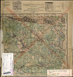
- Description:
- 1934
- Subject:
- Geographic Subject: Verkhnodniprovsk, Topical Subject: Soviet Union, and Topical Subject: Maps
- Publisher:
- Генеральный штаб Красной Армии
- Language:
- Russian
- Date Created:
- 1942
- Identifier:
- VAC9619-001148
- Genre:
- Topographic Maps and Military Maps
- Geographic Location:
- Coordinates: 48.5, 34.25, 48.66667, 34.5
- Related URL:
- Download GeoTIFF: https://drive.google.com/open?id=1NquDG0ggkkjf440DC1fJcLEPNS9Fp8FO and Catalog URL: http://iucat.iu.edu/catalog/5020131
- Abstract:
- Modern area represented: Verkhnodniprovsk, Dnipropetrovsk oblast, Ukraine
- Call Number:
- G7000 s50 .S68 sheet M-36-129-Б
- Caption:
- Для служебного пользования
- City:
- Верхнеднепровск (Verkhnodniprovsk)
- Copyright Holder:
- No Copyright - United States
- Country:
- СССР (USSR)
- State/Province:
- Украинская ССР (Ukrainian Soviet Socialist Republic) and Днепропетровская область (Dnipropetrovsk oblast)
- Physical Description:
- Scale: 1:50,000
- Persistent URL:
- http://purl.dlib.indiana.edu/iudl/images/VAC9619/VAC9619-001148
- Provenance:
- DMA Topographic Center, Army Map Service Library, OMAHA, Library of Congress Geography & Map Division
-
- Description:
- 1941
- Subject:
- Topical Subject: Maps, Geographic Subject: Illarionovo, and Topical Subject: Soviet Union
- Publisher:
- Генеральный штаб Красной Армии
- Language:
- Russian
- Date Created:
- 1942
- Identifier:
- VAC9619-001157
- Genre:
- Topographic Maps and Military Maps
- Geographic Location:
- Coordinates: 48.3333, 35.25, 48.5, 35.5
- Related URL:
- Catalog URL: http://iucat.iu.edu/catalog/5020131 and Download GeoTIFF: https://drive.google.com/open?id=1EwW95_6fSnhi_coPHHifjpp9glLgCuxY
- Abstract:
- Modern area represented: Illarionovo, Dnipropetrovsk oblast, Ukraine
- Call Number:
- GM G7000 s50 .S68 M-36-131-Г
- Caption:
- Для служебного пользования
- City:
- Илларионово (Illarionovo)
- Copyright Holder:
- No Copyright - United States
- Country:
- СССР (USSR)
- State/Province:
- Украинская ССР (Ukrainian Soviet Socialist Republic) and Днепропетровская область (Dnipropetrovsk oblast)
- Physical Description:
- Scale: 1:50,000
- Persistent URL:
- http://purl.dlib.indiana.edu/iudl/images/VAC9619/VAC9619-001157
- Provenance:
- DMA Topographic Center, Army Map Service Library, OMAHA, Library of Congress Geography & Map Division
-
- Description:
- 1932
- Subject:
- Topical Subject: Maps, Geographic Subject: Dnipro, and Topical Subject: Soviet Union
- Publisher:
- Генеральный штаб Красной Армии
- Language:
- Russian
- Date Created:
- 1942
- Identifier:
- VAC9619-001153
- Genre:
- Topographic Maps and Military Maps
- Geographic Location:
- Coordinates: 48.3333, 34.75, 48.5, 35.0
- Related URL:
- Download GeoTIFF: https://drive.google.com/open?id=1yC-G0nK-feDLBjRrMPWUvMJIKczZAtXA and Catalog URL: http://iucat.iu.edu/catalog/5020131
- Abstract:
- Modern area represented: Dnipro, Dnipropetrovsk oblast, Ukraine
- Call Number:
- GM G7000 s50 .S68 M-36-130-Г
- Caption:
- Для служебного пользования
- City:
- Кайдаки (Kaydaki)
- Copyright Holder:
- No Copyright - United States
- Country:
- СССР (USSR)
- State/Province:
- Днепропетровская область (Dnipropetrovsk oblast) and Украинская ССР (Ukrainian Soviet Socialist Republic)
- Physical Description:
- Scale: 1:50,000
- Persistent URL:
- http://purl.dlib.indiana.edu/iudl/images/VAC9619/VAC9619-001153
- Provenance:
- DMA Topographic Center, Army Map Service Library, OMAHA, Library of Congress Geography & Map Division
-
- Description:
- 1938
- Subject:
- Topical Subject: Maps, Geographic Subject: Mohyliv, and Topical Subject: Soviet Union
- Publisher:
- Генеральный штаб Красной Армии
- Language:
- Russian
- Date Created:
- 1942
- Identifier:
- VAC9619-001103
- Genre:
- Topographic Maps and Military Maps
- Geographic Location:
- Coordinates: 48.8667, 34.5, 49, 34.75
- Related URL:
- Catalog URL: http://iucat.iu.edu/catalog/5020131 and Download GeoTIFF: https://drive.google.com/open?id=18FxaTD8QDAJJ62HMsjR_o-qXFZkcSP44
- Abstract:
- Modern area represented: Mohyliv, Dnipropetrovsk oblast, Ukraine
- Call Number:
- G7000 s50 .S68 М-36-118-А
- Caption:
- Для служебного пользования
- City:
- Могилев I (Mohyliv)
- Copyright Holder:
- No Copyright - United States
- Country:
- СССР (USSR)
- State/Province:
- Украинская ССР (Ukrainian Soviet Socialist Republic) and Днепропетровская область (Dnipropetrovsk oblast)
- Physical Description:
- Scale: 1:50,000
- Persistent URL:
- http://purl.dlib.indiana.edu/iudl/images/VAC9619/VAC9619-001103
- Provenance:
- DMA Topographic Center, Army Map Service Library, OMAHA, Library of Congress Geography & Map Division
-
- Description:
- 1937
- Subject:
- Geographic Subject: Drabinovka, Topical Subject: Soviet Union, and Topical Subject: Maps
- Publisher:
- Генеральный штаб Красной Армии
- Language:
- Russian
- Date Created:
- 1942
- Identifier:
- VAC9619-001077
- Genre:
- Military Maps and Topographic Maps
- Geographic Location:
- Coordinates: 49.167, 34.5, 49.333, 34.75
- Related URL:
- Catalog URL: http://iucat.iu.edu/catalog/5020131 and Download GeoTIFF: https://drive.google.com/open?id=1cMOH5wUAvSAJGU72pAzWmuLtzYM3n2LF
- Abstract:
- Modern area represented: Drabinovka, Poltava oblast, Ukraine
- Call Number:
- G7000 s50 .S68 М-36-106-А
- Caption:
- Для служебного пользования
- City:
- Драбиновка (Drabinovka)
- Copyright Holder:
- No Copyright - United States
- Country:
- СССР (USSR)
- State/Province:
- Полтавская область (Poltava oblast) and Украинская ССР (Ukrainian Soviet Socialist Republic)
- Physical Description:
- Scale: 1:50,000
- Persistent URL:
- http://purl.dlib.indiana.edu/iudl/images/VAC9619/VAC9619-001077
- Provenance:
- DMA Topographic Center, Army Map Service Library, OMAHA, Library of Congress Geography & Map Division
-
- Subject:
- Topical Subject: Soviet Union, Topical Subject: Maps, and Geographic Subject: Shlyakhove
- Publisher:
- Генеральный штаб Красной Армии
- Language:
- Russian
- Date Created:
- 1942
- Identifier:
- VAC9619-001051
- Genre:
- Topographic Maps and Military Maps
- Geographic Location:
- Coordinates: 49.3333, 35.75, 49.5, 36
- Related URL:
- Catalog URL: http://iucat.iu.edu/catalog/5020131 and Download GeoTIFF: https://drive.google.com/open?id=1XH0FbLsauJ0csA9pyZr0duL83k4FkW9x
- Abstract:
- Modern area represented: Шляхове (Shlyakhove), Kharkiv oblast, Ukraine
- Call Number:
- G7000 s50 .S68 sheet M-36-96-D
- Caption:
- Для служебного пользования
- City:
- Шляховая (Shlyakhovaya)
- Copyright Holder:
- No Copyright - United States
- Country:
- СССР (USSR)
- State/Province:
- Харьковская область (Kharkiv oblast) and Украинская ССР (Ukrainian Soviet Socialist Republic)
- Physical Description:
- Scale: 1:50,000
- Persistent URL:
- http://purl.dlib.indiana.edu/iudl/images/VAC9619/VAC9619-001051
- Provenance:
- DMA Topographic Center, Army Map Service Library, OMAHA, Library of Congress Geography & Map Division
-
- Description:
- 1941
- Subject:
- Topical Subject: Soviet Union, Topical Subject: Maps, and Geographic Subject: Lychkovo
- Publisher:
- Генеральный штаб Красной Армии
- Language:
- Russian
- Date Created:
- 1942
- Identifier:
- VAC9619-001084
- Genre:
- Topographic Maps and Military Maps
- Geographic Location:
- Coordinates: 49, 35, 49.167, 35.25
- Related URL:
- Download GeoTIFF: https://drive.google.com/open?id=1c1dPNAvI1lXHF3Vgl7j_reumUnWGb_If and Catalog URL: http://iucat.iu.edu/catalog/5020131
- Abstract:
- Modern area represented: Lychkovo, Dnipropetrovsk oblast, Ukraine
- Call Number:
- G7000 s50 .S68 М-36-107-В
- Caption:
- Для служебного пользования
- City:
- Лычково (Lychkovo)
- Copyright Holder:
- No Copyright - United States
- Country:
- СССР (USSR)
- State/Province:
- Полтавская область (Poltava oblast), Днепропетровская область (Dnipropetrovsk oblast), Харьковская область (Kharkiv oblast), and Украинская ССР (Ukrainian So...
- Physical Description:
- Scale: 1:50,000
- Persistent URL:
- http://purl.dlib.indiana.edu/iudl/images/VAC9619/VAC9619-001084
- Provenance:
- DMA Topographic Center, Army Map Service Library, OMAHA, Library of Congress Geography & Map Division
-
- Description:
- 1932
- Subject:
- Geographic Subject: Kirovske, Topical Subject: Soviet Union, and Topical Subject: Maps
- Publisher:
- Генеральный штаб Красной Армии
- Language:
- Russian
- Date Created:
- 1942
- Identifier:
- VAC9619-001152
- Genre:
- Military Maps and Topographic Maps
- Geographic Location:
- Coordinates: 59.167, 25.75, 59.333, 26
- Related URL:
- Catalog URL: http://iucat.iu.edu/catalog/5020131 and Download GeoTIFF: https://drive.google.com/open?id=12_BYD6Lo6WNPwMmTlJWgcRXPjCHAGK8c
- Abstract:
- Modern area represented: Kirovske, Dnipropetrovsk oblast, Ukraine
- Call Number:
- GM G7000 s50 .S68 M-36-130-Б
- Caption:
- Для служебного пользования
- City:
- Кировский (Kirovske)
- Copyright Holder:
- No Copyright - United States
- Country:
- СССР (USSR)
- State/Province:
- Днепропетровская область (Dnipropetrovsk oblast) and Украинская ССР (Ukrainian Soviet Socialist Republic)
- Physical Description:
- Scale: 1:50,000
- Persistent URL:
- http://purl.dlib.indiana.edu/iudl/images/VAC9619/VAC9619-001152
- Provenance:
- DMA Topographic Center, Army Map Service Library, OMAHA, Library of Congress Geography & Map Division
-
- Description:
- 1869
- Subject:
- Topical Subject: Soviet Union, Topical Subject: Maps, and Geographic Subject: Nezabudyne
- Publisher:
- Генеральный штаб Красной Армии
- Language:
- Russian
- Date Created:
- 1942
- Identifier:
- VAC9619-001174
- Genre:
- Military Maps and Topographic Maps
- Geographic Location:
- Coordinates: 48, 34.25, 48.167, 34.5
- Related URL:
- Catalog URL: http://iucat.iu.edu/catalog/5020131 and Download GeoTIFF: https://drive.google.com/open?id=10uM73Mp_ScBsty2SqLkRR-8oq3IRL7Eu
- Abstract:
- Modern area represented: Nezabudyne, Dnipropetrovsk oblast, Ukraine
- Call Number:
- GM G7000 S50 .S68 M-36-141-Г
- Caption:
- Для служебного пользования
- City:
- Незабудина (Nezabudyne)
- Copyright Holder:
- No Copyright - United States
- Country:
- СССР (USSR)
- State/Province:
- Украинская ССР (Ukrainian Soviet Socialist Republic) and Днепропетровская область (Dnipropetrovsk oblast)
- Physical Description:
- Scale: 1:50,000
- Persistent URL:
- http://purl.dlib.indiana.edu/iudl/images/VAC9619/VAC9619-001174
- Provenance:
- DMA Topographic Center, Army Map Service Library, OMAHA, Library of Congress Geography & Map Division
-
- Description:
- 1941
- Subject:
- Geographic Subject: Nekhvoroshcha, Topical Subject: Soviet Union, and Topical Subject: Maps
- Publisher:
- Генеральный штаб Красной Армии
- Language:
- Russian
- Date Created:
- 1942
- Identifier:
- VAC9619-001079
- Genre:
- Topographic Maps and Military Maps
- Geographic Location:
- Coordinates: 49, 34.5, 49.167, 34.75
- Related URL:
- Catalog URL: http://iucat.iu.edu/catalog/5020131 and Download GeoTIFF: https://drive.google.com/open?id=1WoUW_HZPz6iendZfnCpvuS608s7Ucaas
- Abstract:
- Modern area represented: Nekhvoroshcha, Poltava oblast, Ukraine
- Call Number:
- G7000 s50 .S68 М-36-106-В
- Caption:
- Для служебного пользования
- City:
- Нехвороща (Nekhvoroshcha)
- Copyright Holder:
- No Copyright - United States
- Country:
- СССР (USSR)
- State/Province:
- Днепропетровская область (Dnipropetrovsk oblast), Украинская ССР (Ukrainian Soviet Socialist Republic), and Полтавская область (Poltava oblast)
- Physical Description:
- Scale: 1:50,000
- Persistent URL:
- http://purl.dlib.indiana.edu/iudl/images/VAC9619/VAC9619-001079
- Provenance:
- DMA Topographic Center, Army Map Service Library, Library of Congress Geography & Map Division
-
- Description:
- 1941
- Subject:
- Topical Subject: Maps and Topical Subject: Soviet Union
- Publisher:
- Генеральный штаб Красной Армии
- Language:
- Russian
- Date Created:
- 1942
- Identifier:
- VAC9619-001078
- Genre:
- Military Maps and Topographic Maps
- Geographic Location:
- Coordinates: 49.167, 34.75, 49.333, 35
- Related URL:
- Download GeoTIFF: https://drive.google.com/open?id=1lyJHCoSeJzdWYKoZuz4gphm9s1catePe and Catalog URL: http://iucat.iu.edu/catalog/5020131
- Abstract:
- Modern area represented: Ukraine
- Call Number:
- G7000 s50 .S68 М-36-106-Б
- Caption:
- Для служебного пользования
- City:
- Ряжское (Ryazhskoe)
- Copyright Holder:
- No Copyright - United States
- Country:
- СССР (USSR)
- State/Province:
- Днепропетровская область (Dnipropetrovsk oblast), Украинская ССР (Ukrainian Soviet Socialist Republic), and Полтавская область (Poltava oblast)
- Physical Description:
- Scale: 1:50,000
- Persistent URL:
- http://purl.dlib.indiana.edu/iudl/images/VAC9619/VAC9619-001078
- Provenance:
- DMA Topographic Center, Army Map Service Library, OMAHA, Library of Congress Geography & Map Division
-
- Description:
- 1933
- Subject:
- Topical Subject: Soviet Union, Geographic Subject: В’язенка (V'yazenka), and Topical Subject: Maps
- Publisher:
- Генеральный штаб Красной Армии
- Language:
- Russian
- Date Created:
- 1942
- Identifier:
- VAC9619-000925
- Genre:
- Topographic Maps and Military Maps
- Geographic Location:
- Coordinates: 51.3333, 33.75, 51.5, 34
- Related URL:
- Catalog URL: http://iucat.iu.edu/catalog/5020131 and Download GeoTIFF: https://drive.google.com/open?id=1oxdOE7vZvax9I-GTIAlhROXl25X7Nmfj
- Abstract:
- Modern area represented: В’язенка (V'yazenka), Sumy Oblast, Ukraine
- Call Number:
- G7000 s50 .S68 sheet M-36-20-D
- Caption:
- Для служебного пользования
- City:
- Вязенка (Vyazenka)
- Copyright Holder:
- No Copyright - United States
- Country:
- СССР (USSR)
- State/Province:
- Сумская область (Sumy oblast) and Украинская ССР (Ukrainian Soviet Socialist Republic)
- Physical Description:
- Scale: 1:50,000
- Persistent URL:
- http://purl.dlib.indiana.edu/iudl/images/VAC9619/VAC9619-000925
- Provenance:
- DMA Topographic Center, Army Map Service Library, OMAHA, Geographic Names Branch, Library of Congress Geography & Map Division
-

- Description:
- 1926
- Subject:
- Geographic Subject: Balky, Topical Subject: Soviet Union, and Topical Subject: Maps
- Publisher:
- Генеральный штаб Красной Армии
- Language:
- Russian
- Date Created:
- 1941
- Identifier:
- VAC9619-001868
- Genre:
- Topographic Maps and Military Maps
- Geographic Location:
- Coordinates: 47.3333, 34.5, 47.6667, 35
- Related URL:
- Catalog URL: https://iucat.iu.edu/catalog/5020129 and Download GeoTIFF: https://drive.google.com/open?id=1V7PHm7Dg5ABV8yybrFeMKAmxM9f2EO27
- Abstract:
- Modern area represented: Balky, Zaporizhia oblast, Ukraine
- Call Number:
- G7000 s100 .S7 sheet L-36-22
- Caption:
- Для служебного пользования
- City:
- Балки (Balky)
- Copyright Holder:
- No Copyright - United States
- Country:
- СССР (USSR)
- State/Province:
- Украинская ССР (Ukrainian Soviet Socialist Republic)
- Physical Description:
- Scale: 1:100,000
- Persistent URL:
- http://purl.dlib.indiana.edu/iudl/images/VAC9619/VAC9619-001868
- Provenance:
- CIA Map Library
-

- Description:
- 1939
- Subject:
- Topical Subject: Soviet Union, Geographic Subject: Komyshuvakha, and Topical Subject: Maps
- Publisher:
- Генеральный штаб Красной Армии
- Language:
- Russian
- Date Created:
- 1941
- Identifier:
- VAC9619-001844
- Genre:
- Military Maps and Topographic Maps
- Geographic Location:
- Coordinates: 47.6667, 35.5, 48, 36
- Related URL:
- Download GeoTIFF: https://drive.google.com/open?id=1IiavgxI6IZ79dkMzQI3jHmPsU86TTxOH and Catalog URL: https://iucat.iu.edu/catalog/5020129
- Abstract:
- Modern area represented: Komyshuvakha, Zaporizhia oblast, Ukraine
- Call Number:
- G7000 s100 .S7 sheet L-36-12
- Caption:
- Для служебного пользования
- City:
- Камышуваха (Komyshuvakha)
- Copyright Holder:
- No Copyright - United States
- Country:
- СССР (USSR)
- State/Province:
- Запорожская область (Zaporizhia oblast) and Украинская ССР (Ukrainian Soviet Socialist Republic)
- Physical Description:
- Scale: 1:100,000
- Persistent URL:
- http://purl.dlib.indiana.edu/iudl/images/VAC9619/VAC9619-001844
- Provenance:
- CIA Map Library
-

- Description:
- 1931
- Subject:
- Geographic Subject: Ivanitsa, Topical Subject: Soviet Union, and Topical Subject: Maps
- Publisher:
- Генеральный штаб Красной Армии
- Language:
- Russian
- Date Created:
- 1941
- Identifier:
- VAC9619-003284
- Genre:
- Topographic Maps and Military Maps
- Geographic Location:
- Coordinates: 50.667, 32.5, 51, 33
- Related URL:
- Download GeoTIFF: https://drive.google.com/file/d/1gP3A56Jcp0_cOWputIwelkHJ5U_WsUb0/view?usp=sharing and Catalog URL: https://iucat.iu.edu/catalog/5020129
- Abstract:
- Modern area represented: Ivanitsa, Chernihiv oblast, Ukraine
- Call Number:
- G7000 s100 .S7 sheet M-36-42
- City:
- Иваница (Ivanitsa)
- Copyright Holder:
- No Copyright - United States
- Country:
- СССР (USSR)
- State/Province:
- Сумская область (Sumy oblast), Украинская ССР (Ukrainian Soviet Socialist Republic), and Черниговская область (Chernihiv oblast)
- Physical Description:
- Scale: 1:100,000
- Persistent URL:
- http://purl.dlib.indiana.edu/iudl/images/VAC9619/VAC9619-003284
- Provenance:
- DMA Topographic Center, Army Map Service Library, OMAHA, Library of Congress Geography & Map Division
-

- Description:
- 1931
- Subject:
- Topical Subject: Soviet Union, Topical Subject: Maps, and Geographic Subject: Buryn
- Publisher:
- Генеральный штаб Красной Армии
- Language:
- Russian
- Date Created:
- 1941
- Identifier:
- VAC9619-003276
- Genre:
- Topographic Maps and Military Maps
- Geographic Location:
- Coordinates: 51, 33.5, 51.333, 34
- Related URL:
- Download GeoTIFF: https://drive.google.com/file/d/10jq_TkKzUvow_gS6D_8zvgSI_5luv7EW/view?usp=sharing and Catalog URL: https://iucat.iu.edu/catalog/5020129
- Abstract:
- Modern area represented: Buryn, Sumy oblast, Ukraine
- Call Number:
- G7000 s100 .S7 sheet M-36-32
- City:
- Бурынь (Buryn)
- Copyright Holder:
- No Copyright - United States
- Country:
- СССР (USSR)
- State/Province:
- Украинская ССР (Ukrainian Soviet Socialist Republic) and Сумская область (Sumy oblast)
- Physical Description:
- Scale: 1:100,000
- Persistent URL:
- http://purl.dlib.indiana.edu/iudl/images/VAC9619/VAC9619-003276
- Provenance:
- DMA Topographic Center, Army Map Service Library, Geographic Names Branch
-
- Description:
- 1938
- Subject:
- Topical Subject: Soviet Union, Topical Subject: Maps, and Geographic Subject: Ponornitsa
- Publisher:
- Главное управление геодезии и картографии при СНК СССР
- Language:
- Russian
- Date Created:
- 1941
- Identifier:
- VAC9619-003258
- Genre:
- Topographic Maps and Military Maps
- Geographic Location:
- Coordinates: 51.667, 32.5, 52, 33
- Related URL:
- Download GeoTIFF: https://drive.google.com/file/d/1jcMqiw4doviC_niimFRwaVdI-Gcl6YTQ/view?usp=sharing and Catalog URL: https://iucat.iu.edu/catalog/5020129
- Abstract:
- Modern area represented: Ponornitsa, Chernihiv oblast, Ukraine
- Call Number:
- G7000 s100 .S7 sheet M-36-6
- City:
- Понорница (Ponornitsa)
- Copyright Holder:
- No Copyright - United States
- Country:
- СССР (USSR)
- State/Province:
- Черниговская область (Chernihiv oblast) and Украинская ССР (Ukrainian Soviet Socialist Republic)
- Physical Description:
- Scale: 1:100,000
- Persistent URL:
- http://purl.dlib.indiana.edu/iudl/images/VAC9619/VAC9619-003258
- Provenance:
- DMA Topographic Center, Army Map Service Library, OMAHA, Auswärtiges Amt. Geographischer Dienst
-

- Description:
- 1938
- Subject:
- Geographic Subject: Novhorod-Siverskyy, Topical Subject: Maps, and Topical Subject: Soviet Union
- Publisher:
- Главное Управление Геодезии и Картографии при СНК СССР
- Language:
- Russian
- Date Created:
- 1941
- Identifier:
- VAC9619-004216
- Genre:
- Military Maps and Topographic Maps
- Geographic Location:
- Coordinates: 52, 33, 52.333, 33.5
- Related URL:
- Download GeoTIFF: https://drive.google.com/file/d/1kaJZgYyUS6Hj_BGfB5UeL-vO4ElM_lO7/view?usp=sharing and Catalog URL: https://iucat.iu.edu/catalog/5020129
- Abstract:
- Modern area represented: Novhorod-Siverskyy, Chernihiv oblast, Ukraine
- Call Number:
- G7000 s100 .S7 sheet N-36-139
- Caption:
- Для служебного пользования
- City:
- Новгород-Северский (Novhorod-Siverskyy)
- Copyright Holder:
- No Copyright - United States
- Country:
- СССР (USSR)
- State/Province:
- Черниговская область (Chernihiv oblast), Украинская ССР (Ukrainian Soviet Socialist Republic), Сумская область (Sumy oblast), РСФСР (RSFSR), and Орловская об...
- Physical Description:
- Scale: 1:100,000
- Persistent URL:
- http://purl.dlib.indiana.edu/iudl/images/VAC9619/VAC9619-004216
- Provenance:
- DMA Topographic Center, Army Map Service Library, OMAHA, Library of Congress Geography & Map Division
-
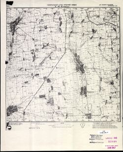
- Description:
- 1930
- Subject:
- Topical Subject: Maps, Geographic Subject: Novyy Buh, and Topical Subject: Soviet Union
- Publisher:
- Генеральный штаб Красной Армии
- Language:
- Russian
- Date Created:
- 1941
- Identifier:
- VAC9619-001863
- Genre:
- Military Maps and Topographic Maps
- Geographic Location:
- Coordinates: 47.6667, 32.5, 48, 33
- Related URL:
- Download GeoTIFF: https://drive.google.com/open?id=1T0wPHo0RpDwORrKZXGfpt1IyrZgBA6b4 and Catalog URL: https://iucat.iu.edu/catalog/5020129
- Abstract:
- Modern area represented: Novyy Buh, Mykolaiv, Ukraine
- Call Number:
- G7000 s100 .S7 sheet L-36-6
- Caption:
- Для служебного пользования
- City:
- Новый Буг (Novyy Buh)
- Copyright Holder:
- No Copyright - United States
- Country:
- СССР (USSR)
- State/Province:
- Украинская ССР (Ukrainian Soviet Socialist Republic)
- Physical Description:
- Scale: 1:100,000
- Persistent URL:
- http://purl.dlib.indiana.edu/iudl/images/VAC9619/VAC9619-001863
- Provenance:
- CIA Map Library
-

- Description:
- 1928
- Subject:
- Topical Subject: Soviet Union, Geographic Subject: Yahotyn, and Topical Subject: Maps
- Publisher:
- Генеральный штаб Красной Армии
- Language:
- Russian
- Date Created:
- 1941
- Identifier:
- VAC9619-003293
- Genre:
- Topographic Maps and Military Maps
- Geographic Location:
- Coordinates: 50, 31.5, 50.333, 32
- Related URL:
- Catalog URL: https://iucat.iu.edu/catalog/5020129 and Download GeoTIFF: https://drive.google.com/file/d/1LHmrE7SLHHk3jOpjngs2HIPoYbavjsT9/view?usp=sharing
- Abstract:
- Modern area represented: Yahotyn, Kiev oblast, Ukraine
- Call Number:
- G7000 s100 .S7 sheet M-36-64
- City:
- Яготин (Yahotyn)
- Copyright Holder:
- No Copyright - United States
- Country:
- СССР (USSR)
- State/Province:
- Черниговская область (Chernihiv oblast), Киевская область (Kyiv oblast), Украинская ССР (Ukrainian Soviet Socialist Republic), and Полтавская область (Poltav...
- Physical Description:
- Scale: 1:100,000
- Persistent URL:
- http://purl.dlib.indiana.edu/iudl/images/VAC9619/VAC9619-003293
- Provenance:
- DMA Topographic Center, Army Map Service Library, OMAHA, Library of Congress Geography & Map Division
-
- Description:
- 1916
- Subject:
- Geographic Subject: Bohuslav, Topical Subject: Maps, and Topical Subject: Soviet Union
- Publisher:
- Генеральный штаб Красной Армии
- Language:
- Russian
- Date Created:
- 1941
- Identifier:
- VAC9619-003300
- Genre:
- Military Maps and Topographic Maps
- Geographic Location:
- Coordinates: 51.333, 24.5, 51.667, 25
- Related URL:
- Download GeoTIFF: https://drive.google.com/file/d/1odAb6QmUNYwAarOu4M6GwN34sjA31HHV/view?usp=sharing and Catalog URL: https://iucat.iu.edu/catalog/5020129
- Abstract:
- Modern area represented: Bohuslav, Kiev oblast, Ukraine
- Call Number:
- G7000 s100 .S7 sheet M-36-86
- Caption:
- Для служебного пользования
- City:
- Богуслав (Bohuslav)
- Copyright Holder:
- No Copyright - United States
- Country:
- СССР (USSR)
- State/Province:
- Украинская ССР (Ukrainian Soviet Socialist Republic) and Киевская область (Kyiv oblast)
- Physical Description:
- Scale: 1:100,000
- Persistent URL:
- http://purl.dlib.indiana.edu/iudl/images/VAC9619/VAC9619-003300
- Provenance:
- DMA Topographic Center, Army Map Service Library, OMAHA, Library of Congress Geography & Map Division
-
- Description:
- 1939
- Subject:
- Topical Subject: Soviet Union, Topical Subject: Maps, and Geographic Subject: Voronezh
- Publisher:
- Главное управление геодезии и картографии при СНК СССР
- Language:
- Russian
- Date Created:
- 1941
- Identifier:
- VAC9619-003259
- Genre:
- Topographic Maps and Military Maps
- Geographic Location:
- Coordinates: 51.667, 33, 52, 33.5
- Related URL:
- Catalog URL: https://iucat.iu.edu/catalog/5020129 and Download GeoTIFF: https://drive.google.com/file/d/1wkzHfaQ0hqJWsSKZl0nr7EeOORHorj2j/view?usp=sharing
- Abstract:
- Modern area represented: Voronezh, Sumy oblast, Ukraine
- Call Number:
- G7000 s100 .S7 sheet M-36-7
- City:
- Воронеж (Voronezh)
- Copyright Holder:
- No Copyright - United States
- Country:
- СССР (USSR)
- State/Province:
- Украинская ССР (Ukrainian Soviet Socialist Republic), Сумская область (Sumy oblast), and Черниговская область (Chernihiv oblast)
- Physical Description:
- Scale: 1:100,000
- Persistent URL:
- http://purl.dlib.indiana.edu/iudl/images/VAC9619/VAC9619-003259
- Provenance:
- DMA Topographic Center, Army Map Service Library, OMAHA, Atlasblatt
-
- Description:
- 1923
- Subject:
- Topical Subject: Maps, Topical Subject: Soviet Union, and Geographic Subject: Ostër
- Publisher:
- Генеральный штаб Красной Армии
- Language:
- Russian
- Date Created:
- 1941
- Identifier:
- VAC9619-003280
- Genre:
- Topographic Maps and Military Maps
- Geographic Location:
- Coordinates: 50.667, 30.5, 51, 31
- Related URL:
- Catalog URL: https://iucat.iu.edu/catalog/5020129 and Download GeoTIFF: https://drive.google.com/file/d/1m3UY9nYFB44VSTNKxgsH-afaAlial0tG/view?usp=sharing
- Abstract:
- Modern area represented: Ostër, Chernihiv oblast, Ukraine
- Call Number:
- G7000 s100 .S7 sheet M-36-38
- Caption:
- Для служебного пользования
- City:
- Остер (Ostër)
- Copyright Holder:
- No Copyright - United States
- Country:
- СССР (USSR)
- State/Province:
- Киевская область (Kyiv oblast) and Украинская ССР (Ukrainian Soviet Socialist Republic)
- Physical Description:
- Scale: 1:100,000
- Persistent URL:
- http://purl.dlib.indiana.edu/iudl/images/VAC9619/VAC9619-003280
- Provenance:
- DMA Topographic Center, Geographic Names Branch, OMAHA, Army Map Service Library, Library of Congress Geography & Map Division
-
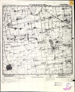
- Description:
- 1921
- Subject:
- Topical Subject: Maps, Geographic Subject: Askania-Nova, and Topical Subject: Soviet Union
- Publisher:
- Генеральный штаб Красной Армии
- Language:
- Russian
- Date Created:
- 1941
- Identifier:
- VAC9619-001908
- Genre:
- Topographic Maps and Military Maps
- Geographic Location:
- Coordinates: 46.3333, 33.5, 46.6667, 34
- Related URL:
- Download GeoTIFF: https://drive.google.com/open?id=1X2zli5lz_FZwB19KYsJ72lmGfakR0GSR and Catalog URL: https://iucat.iu.edu/catalog/5020129
- Abstract:
- Modern area represented: Askania-Nova, Kherson oblast, Ukraine
- Call Number:
- G7000 s100 .S7 sheet L-36-56
- Caption:
- Для служебного пользования
- City:
- Аскания Нова (Askania-Nova)
- Copyright Holder:
- No Copyright - United States
- Country:
- СССР (USSR)
- State/Province:
- Запорожская область (Zaporizhia oblast), Украинская ССР (Ukrainian Soviet Socialist Republic), and Николаевская область (Mykolaiv oblast)
- Physical Description:
- Scale: 1:100,000
- Persistent URL:
- http://purl.dlib.indiana.edu/iudl/images/VAC9619/VAC9619-001908
- Provenance:
- CIA Map Library, Army Map Service Library
-
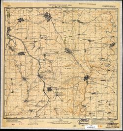
- Description:
- 1939
- Subject:
- Geographic Subject: Donetsk, Topical Subject: Soviet Union, Geographic Subject: Platonovka, and Topical Subject: Maps
- Publisher:
- Генеральный штаб Красной Армии
- Language:
- Russian
- Date Created:
- 1941
- Identifier:
- VAC9619-002002
- Genre:
- Topographic Maps and Military Maps
- Geographic Location:
- Coordinates: 47.3333, 37.5, 47.6667, 37.5
- Related URL:
- Catalog URL: https://iucat.iu.edu/catalog/5020129 and Download GeoTIFF: https://drive.google.com/open?id=1rcAVudLKQYH89ByRQ8FaN6st2evLxa46
- Abstract:
- Modern area represented: Платоновка (Platonovka), Donetsk, Ukraine
- Call Number:
- G7000 s100 .S7 sheet L-37-16
- Caption:
- Для cлужебного пользования
- City:
- Платоновка (Platonovka)
- Copyright Holder:
- No Copyright - United States
- Country:
- СССР (USSR)
- State/Province:
- Украинская ССР (Ukrainian Soviet Socialist Republic) and Сталинская область (Stalino oblast)
- Physical Description:
- Scale: 1:100,000
- Persistent URL:
- http://purl.dlib.indiana.edu/iudl/images/VAC9619/VAC9619-002002
- Provenance:
- Geographic Names Branch
-
- Description:
- 1929
- Subject:
- Geographic Subject: Derhachi, Topical Subject: Soviet Union, and Topical Subject: Maps
- Publisher:
- Генеральный штаб Красной Армии
- Language:
- Russian
- Date Created:
- 1941
- Identifier:
- VAC9619-003388
- Genre:
- Topographic Maps and Military Maps
- Geographic Location:
- Coordinates: 50, 36, 50.333, 36.5
- Related URL:
- Catalog URL: https://iucat.iu.edu/catalog/5020129 and Download GeoTIFF: https://drive.google.com/file/d/1_5nhCPC3E-jfDcJk-rDeFvngeE9VgOZG/view?usp=sharing
- Abstract:
- Modern area represented: Derhachi, Kharkiv oblast, Ukraine
- Call Number:
- G7000 s100 .S7 sheet M-37-61
- Caption:
- Секретно
- City:
- Дергачи (Derhachi)
- Copyright Holder:
- No Copyright - United States
- Country:
- СССР (USSR)
- State/Province:
- Курская область (Kursk oblast), Украинская ССР (Ukrainian Soviet Socialist Republic), РСФСР (RSFSR), and Харьковская область (Kharkiv oblast)
- Physical Description:
- Scale: 1:100,000
- Persistent URL:
- http://purl.dlib.indiana.edu/iudl/images/VAC9619/VAC9619-003388
- Provenance:
- Army Map Service Library, Library of Congress G & M Division, Geographic Names Branch
-
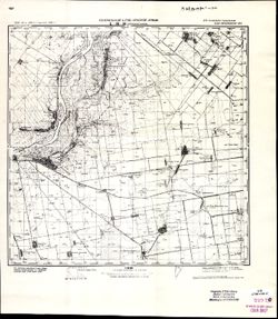
- Description:
- 1928
- Subject:
- Geographic Subject: Kairy, Topical Subject: Maps, and Topical Subject: Soviet Union
- Publisher:
- Генеральный штаб Красной Армии
- Language:
- Russian
- Date Created:
- 1941
- Identifier:
- VAC9619-001889
- Genre:
- Topographic Maps and Military Maps
- Geographic Location:
- Coordinates: 46.6667, 33.5, 47, 34
- Related URL:
- Catalog URL: https://iucat.iu.edu/catalog/5020129 and Download GeoTIFF: https://drive.google.com/file/d/1osSsR-E4nP09v5-wiUbmEixGdIeS0X75/view?usp=sharing
- Abstract:
- Modern area represented: Kayiry, Kherson oblast, Ukraine
- Call Number:
- G7000 s100 .S7 sheet L-36-44
- Caption:
- Для служебного пользования
- City:
- Западные Каиры (Zapadnye Kairy)
- Copyright Holder:
- No Copyright - United States
- Country:
- СССР (USSR)
- State/Province:
- Николаевская область (Mykolaiv oblast) and Украинская ССР (Ukrainian Soviet Socialist Republic)
- Physical Description:
- Scale: 1:100,000
- Persistent URL:
- http://purl.dlib.indiana.edu/iudl/images/VAC9619/VAC9619-001889
- Provenance:
- CIA Map Library, Atlasblatt
-
- Description:
- 1923
- Subject:
- Topical Subject: Soviet Union, Topical Subject: Maps, and Geographic Subject: Beryslav
- Publisher:
- Генеральный штаб Красной Армии
- Language:
- Russian
- Date Created:
- 1941
- Identifier:
- VAC9619-001887
- Genre:
- Topographic Maps and Military Maps
- Geographic Location:
- Coordinates: 46.6667, 33, 47, 33.5
- Related URL:
- Catalog URL: https://iucat.iu.edu/catalog/5020129 and Download GeoTIFF: https://drive.google.com/open?id=15CCT7KeDTW2OAhyErSFxC6JA8ziWovVn
- Abstract:
- Modern area represented: Beryslav, Kherson oblast, Ukraine
- Call Number:
- G7000 s100 .S7 sheet L-36-43
- Caption:
- Для служебного пользования
- City:
- Берислав (Beryslav)
- Copyright Holder:
- No Copyright - United States
- Country:
- СССР (USSR)
- State/Province:
- Николаевская область (Mykolaiv oblast) and Украинская ССР (Ukrainian Soviet Socialist Republic)
- Physical Description:
- Scale: 1:100,000
- Persistent URL:
- http://purl.dlib.indiana.edu/iudl/images/VAC9619/VAC9619-001887
- Provenance:
- DMA Topographic Center, Army Map Service Library, OMAHA
-
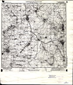
- Description:
- 1895
- Subject:
- Geographic Subject: Ilovays'k, Topical Subject: Soviet Union, and Topical Subject: Maps
- Publisher:
- Генеральный штаб Красной Армии
- Language:
- Russian
- Date Created:
- 1941
- Identifier:
- VAC9619-001991
- Genre:
- Military Maps and Topographic Maps
- Geographic Location:
- Coordinates: 47.6667, 38, 48, 38.5
- Related URL:
- Download GeoTIFF: https://drive.google.com/open?id=1kH7oS86WKdYFUSnKJLcOrEqzxFAZpxdS and Catalog URL: https://iucat.iu.edu/catalog/5020129
- Abstract:
- Modern area represented: Иловайск (Ilovays'k), Ukraine
- Call Number:
- G7000 s100 .S7 sheet L-37-5
- Caption:
- Для cлужебного пользования
- City:
- Иловайск (Ilovaĭsk)
- Copyright Holder:
- No Copyright - United States
- Country:
- СССР (USSR)
- State/Province:
- Украинская ССР (Ukrainian Soviet Socialist Republic) and Сталинская область (Stalino oblast)
- Physical Description:
- Scale: 1:100,000
- Persistent URL:
- http://purl.dlib.indiana.edu/iudl/images/VAC9619/VAC9619-001991
- Provenance:
- CIA Map Library
-
- Description:
- 1928
- Subject:
- Topical Subject: Maps, Geographic Subject: Nosivka, and Topical Subject: Soviet Union
- Publisher:
- Генеральный штаб Красной Армии
- Language:
- Russian
- Date Created:
- 1941
- Identifier:
- VAC9619-003282
- Genre:
- Topographic Maps and Military Maps
- Geographic Location:
- Coordinates: 50.667, 31.5, 51, 32
- Related URL:
- Download GeoTIFF: https://drive.google.com/file/d/10MygBybi2xuqc14bonfjkweaMqUlhu2F/view?usp=sharing and Catalog URL: https://iucat.iu.edu/catalog/5020129
- Abstract:
- Modern area represented: Nosivka, Chernihiv oblast, Ukraine
- Call Number:
- G7000 s100 .S7 sheet M-36-40
- City:
- Носовка (Nosivka)
- Copyright Holder:
- No Copyright - United States
- Country:
- СССР (USSR)
- State/Province:
- Черниговская область (Chernihiv oblast) and Украинская ССР (Ukrainian Soviet Socialist Republic)
- Physical Description:
- Scale: 1:100,000
- Persistent URL:
- http://purl.dlib.indiana.edu/iudl/images/VAC9619/VAC9619-003282
- Provenance:
- DMA Topographic Center, Army Map Service Library, Geographic Names Branch
-
- Description:
- 1929
- Subject:
- Topical Subject: Soviet Union, Geographic Subject: Oleksandrivka, and Topical Subject: Maps
- Publisher:
- Генеральный штаб Красной Армии
- Language:
- Russian
- Date Created:
- 1941
- Identifier:
- VAC9619-003303
- Genre:
- Military Maps and Topographic Maps
- Geographic Location:
- Coordinates: 48.6667, 32.0, 49.0, 32.5
- Related URL:
- Download GeoTIFF: https://drive.google.com/file/d/17CYndFHHZthXYXSHRjdk3ND7evn1ALSl/view?usp=sharing and Catalog URL: https://iucat.iu.edu/catalog/5020129
- Abstract:
- Modern area represented: Oleksandrivka, Kirovohrad oblast, Ukraine
- Call Number:
- G7000 s100 .S7 sheet M-36-113
- Caption:
- Для служебного пользования
- City:
- Александровка (Oleksandrivka)
- Copyright Holder:
- No Copyright - United States
- Country:
- СССР (USSR)
- State/Province:
- Украинская ССР (Ukrainian Soviet Socialist Republic)
- Physical Description:
- Scale: 1:100,000
- Persistent URL:
- http://purl.dlib.indiana.edu/iudl/images/VAC9619/VAC9619-003303
- Provenance:
- DMA Topographic Center, Army Map Service Library, OMAHA, Library of Congress Geography & Map Division
-
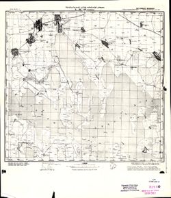
- Description:
- 1933
- Subject:
- Geographic Subject: Hromivka, Topical Subject: Soviet Union, and Topical Subject: Maps
- Publisher:
- Генеральный штаб Красной Армии
- Language:
- Russian
- Date Created:
- 1941
- Identifier:
- VAC9619-001923
- Genre:
- Topographic Maps and Military Maps
- Geographic Location:
- Coordinates: 46, 34, 46.3333, 34.5
- Related URL:
- Download GeoTIFF: https://drive.google.com/open?id=1sOMPSRT5vHzGSJy5FqPqnkWmkwqYR5YH and Catalog URL: https://iucat.iu.edu/catalog/5020129
- Abstract:
- Modern area represented: Hromivka, Kherson oblast, Ukraine
- Call Number:
- G7000 s100 .S7 sheet L-36-69
- Caption:
- Для служебного пользования
- City:
- Громовка (Gromovka)
- Copyright Holder:
- No Copyright - United States
- Country:
- СССР (USSR)
- State/Province:
- Украинская ССР (Ukrainian Soviet Socialist Republic), Крымская АССР (Crimean Autonomous Soviet Socialist Republic), Запорожская область (Zaporizhia oblast), ...
- Physical Description:
- Scale: 1:100,000
- Persistent URL:
- http://purl.dlib.indiana.edu/iudl/images/VAC9619/VAC9619-001923
- Provenance:
- CIA Map Library
