
Search Constraints
You searched for:
Date Created
1941
Remove constraint Date Created: 1941
State/Province
Ростовская область (Rostov oblast)
Remove constraint State/Province: Ростовская область (Rostov oblast)
« Previous |
1 - 10 of 72
|
Next »
Search Results
-

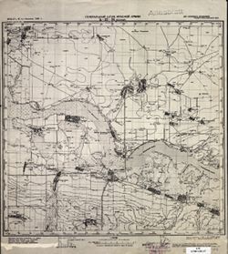
- Description:
- 1938
- Subject:
- Topical Subject: Maps, Geographic Subject: Krasnogvardeyskoe, and Topical Subject: Soviet Union
- Publisher:
- Главное управление геодезии и картографии при СНК СССР
- Language:
- Russian
- Date Created:
- 1941
- Identifier:
- VAC9619-002343
- Genre:
- Topographic Maps and Military Maps
- Geographic Location:
- Coordinates: 45.667, 41.5, 46, 42
- Related URL:
- Download GeoTIFF: https://drive.google.com/file/d/1AVr-cwCpH2TyChEw-jxKdVkFJnNQ8ff2/view?usp=sharing and Catalog URL: https://iucat.iu.edu/catalog/5020129
- Abstract:
- Modern area represented: Krasnogvardeyskoe, Stavropol kray, Russia
- Call Number:
- G7000 s100 .S7 sheet L-37-84
- Caption:
- Для служебного пользования
- City:
- Молотовское (Molotovskoe)
- Copyright Holder:
- No Copyright - United States
- Country:
- СССР (USSR)
- State/Province:
- Орджоникидзевский край (Ordzhonikidze kray), Калмыцкая АССР (Kalmyk Autonomous Soviet Socialist Republic), Ростовская область (Rostov oblast), and РСФСР (RSFSR)
- Physical Description:
- Scale: 1:100,000
- Persistent URL:
- http://purl.dlib.indiana.edu/iudl/images/VAC9619/VAC9619-002343
- Provenance:
- DMA Topographic Center, Army Map Service Library, OMAHA
-

- Description:
- 1926
- Subject:
- Topical Subject: Soviet Union, Geographic Subject: Sirotskiy, and Topical Subject: Maps
- Publisher:
- Генеральный штаб Красной Армии
- Language:
- Russian
- Date Created:
- 1941
- Identifier:
- VAC9619-002461
- Genre:
- Military Maps and Topographic Maps
- Geographic Location:
- Coordinates: 47, 43, 47.333, 43.5
- Related URL:
- Download GeoTIFF: https://drive.google.com/file/d/1lKyxlwfueH8iSqR8tLrAkEEVeuu5mIWT/view?usp=sharing and Catalog URL: https://iucat.iu.edu/catalog/5020129
- Abstract:
- Modern area represented: Sirotskiy, Russia
- Call Number:
- G7000 s100 .S7 sheet L-38-27
- Caption:
- Для служебного пользования
- City:
- Сиротский (Sirotskiy)
- Copyright Holder:
- No Copyright - United States
- Country:
- СССР (USSR)
- State/Province:
- РСФСР (RSFSR) and Ростовская область (Rostov oblast)
- Physical Description:
- Scale: 1:100,000
- Persistent URL:
- http://purl.dlib.indiana.edu/iudl/images/VAC9619/VAC9619-002461
- Provenance:
- DMA Topographic Center, Army Map Service Library
-
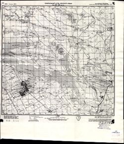
- Description:
- 1928
- Subject:
- Topical Subject: Soviet Union, Topical Subject: Maps, and Geographic Subject: Manychskoye
- Publisher:
- Генеральный штаб Красной Армии
- Language:
- Russian
- Date Created:
- 1941
- Identifier:
- VAC9619-002064
- Genre:
- Topographic Maps and Military Maps
- Geographic Location:
- Coordinates: 46, 43, 46.3333, 43.5
- Related URL:
- Download GeoTIFF: https://drive.google.com/file/d/1PLQflQVDyBA9NJ-6naJtI9EWyhWo5eFY/view?usp=sharing and Catalog URL: https://iucat.iu.edu/catalog/5020129
- Abstract:
- Modern area represented: Manychskoye, Stavropol kray, Russia
- Call Number:
- G7000 s100 .S7 sheet L-38-63
- Caption:
- Для служебного пользования
- City:
- Киста (Kista)
- Copyright Holder:
- No Copyright - United States
- Country:
- СССР (USSR)
- State/Province:
- Ростовская область (Rostov oblast), Орджоникидзевский край (Ordzhonikidze kray), Калмыцкая АССР (Kalmyk Autonomous Soviet Socialist Republic), and РСФСР (RSFSR)
- Physical Description:
- Scale: 1:100,000
- Persistent URL:
- http://purl.dlib.indiana.edu/iudl/images/VAC9619/VAC9619-002064
- Provenance:
- DMA Topographic Center, Library of Congress Geography & Map Division, Army Map Service Library, OMAHA
-
- Description:
- 1925
- Subject:
- Topical Subject: Soviet Union, Geographic Subject: Tsimlyansk, and Topical Subject: Maps
- Publisher:
- Генеральный штаб Красной Армии
- Language:
- Russian
- Date Created:
- 1941
- Identifier:
- VAC9619-002446
- Genre:
- Military Maps and Topographic Maps
- Geographic Location:
- Coordinates: 47.667, 42, 48, 42.5
- Related URL:
- Catalog URL: https://iucat.iu.edu/catalog/5020129 and Download GeoTIFF: https://drive.google.com/file/d/1Fq1CUNGjISP3jwHQkOyng30sRx-ec3HY/view?usp=sharing
- Abstract:
- Modern area represented: Tsimlyansk, Russia
- Call Number:
- G7000 s100 .S7 sheet L-38-1
- Caption:
- Для служебного пользования
- City:
- Цымлянская (Tsimlyanskaya)
- Copyright Holder:
- No Copyright - United States
- Country:
- СССР (USSR)
- State/Province:
- РСФСР (RSFSR) and Ростовская область (Rostov oblast)
- Physical Description:
- Scale: 1:100,000
- Persistent URL:
- http://purl.dlib.indiana.edu/iudl/images/VAC9619/VAC9619-002446
- Provenance:
- Army Map Service Library, Library of Congress G & M Division
-
- Description:
- 1932
- Subject:
- Topical Subject: Soviet Union, Topical Subject: Maps, and Geographic Subject: Veselyy
- Publisher:
- Генеральный штаб Красной Армии
- Language:
- Russian
- Date Created:
- 1941
- Identifier:
- VAC9619-002288
- Genre:
- Topographic Maps and Military Maps
- Geographic Location:
- Coordinates: 47, 40.5, 47.3333, 41
- Related URL:
- Download GeoTIFF: https://drive.google.com/file/d/1x_6moHatJsnMhQhHzqjSPuO0h_az_FsS/view?usp=sharing and Catalog URL: https://iucat.iu.edu/catalog/5020129
- Abstract:
- Modern area represented: Veselyy, Russia
- Call Number:
- G7000 s100 .S7 sheet L-37-34
- Caption:
- Для служебного пользования
- City:
- Веселый (Veselyy)
- Copyright Holder:
- No Copyright - United States
- Country:
- СССР (USSR)
- State/Province:
- Ростовская область (Rostov oblast) and РСФСР (RSFSR)
- Physical Description:
- Scale: 1:100,000
- Persistent URL:
- http://purl.dlib.indiana.edu/iudl/images/VAC9619/VAC9619-002288
- Provenance:
- CIA Map Library
-
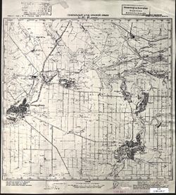
- Description:
- 1928
- Subject:
- Geographic Subject: Manychskoye, Topical Subject: Soviet Union, and Topical Subject: Maps
- Publisher:
- Генеральный штаб Красной Армии
- Language:
- Russian
- Date Created:
- 1941
- Identifier:
- VAC9619-002063
- Genre:
- Topographic Maps and Military Maps
- Geographic Location:
- Coordinates: 46, 43, 46.3333, 43.5
- Related URL:
- Download GeoTIFF: https://drive.google.com/open?id=1n-R1bSl6LZW_J3pMeBtQTM79GYtOIJNr and Catalog URL: https://iucat.iu.edu/catalog/5020129
- Abstract:
- Modern area represented: Manychskoye, Stavropol kray, Russia
- Call Number:
- G7000 s100 .S7 sheet L-38-63
- Caption:
- Для служебного пользования
- City:
- Киста (Kista)
- Copyright Holder:
- No Copyright - United States
- Country:
- СССР (USSR)
- State/Province:
- Орджоникидзевский край (Ordzhonikidze kray), Калмыцкая АССР (Kalmyk Autonomous Soviet Socialist Republic), РСФСР (RSFSR), and Ростовская область (Rostov oblast)
- Physical Description:
- Scale: 1:100,000
- Persistent URL:
- http://purl.dlib.indiana.edu/iudl/images/VAC9619/VAC9619-002063
- Provenance:
- CIA Map Library
-
- Description:
- 1940
- Subject:
- Geographic Subject: Nezamayevskaya, Topical Subject: Soviet Union, and Topical Subject: Maps
- Publisher:
- Генеральный штаб Красной Армии
- Language:
- Russian
- Date Created:
- 1941
- Identifier:
- VAC9619-002331
- Genre:
- Military Maps and Topographic Maps
- Geographic Location:
- Coordinates: 46, 40, 46.3333, 40.5
- Related URL:
- Catalog URL: https://iucat.iu.edu/catalog/5020129 and Download GeoTIFF: https://drive.google.com/file/d/1KWYrAI3qHrR_O6WF5vmeSjmXKm7q3Sio/view?usp=sharing
- Abstract:
- Modern area represented: Nezamayevskaya, Russia
- Call Number:
- G7000 s100 .S7 sheet L-37-69
- Caption:
- Для служебного пользования
- City:
- Незамаевская (Nezamayevskaya)
- Copyright Holder:
- No Copyright - United States
- Country:
- СССР (USSR)
- State/Province:
- Ростовская область (Rostov oblast), РСФСР (RSFSR), and Краснодарский край (Krasnodar kray)
- Physical Description:
- Scale: 1:100,000
- Persistent URL:
- http://purl.dlib.indiana.edu/iudl/images/VAC9619/VAC9619-002331
- Provenance:
- CIA Map Library
-
- Description:
- 1927
- Subject:
- Topical Subject: Maps, Geographic Subject: Samarskoe, and Topical Subject: Soviet Union
- Publisher:
- Генеральный штаб Красной Армии
- Language:
- Russian
- Date Created:
- 1941
- Identifier:
- VAC9619-002295
- Genre:
- Topographic Maps and Military Maps
- Geographic Location:
- Coordinates: 46.6667, 39.5, 47, 40
- Related URL:
- Download GeoTIFF: https://drive.google.com/file/d/1_26etJDL3qxqsjyI95YqndQ-0poVd8mx/view?usp=sharing and Catalog URL: https://iucat.iu.edu/catalog/5020129
- Abstract:
- Modern area represented: Samarskoe, Rostov oblast, Russia
- Call Number:
- G7000 s100 .S7 sheet L-37-44
- Caption:
- Для служебного пользования
- City:
- Самарское (Samarskoe)
- Copyright Holder:
- No Copyright - United States
- Country:
- СССР (USSR)
- State/Province:
- Ростовская область (Rostov oblast), Краснодарский край (Krasnodar kray), and РСФСР (RSFSR)
- Physical Description:
- Scale: 1:100,000
- Persistent URL:
- http://purl.dlib.indiana.edu/iudl/images/VAC9619/VAC9619-002295
- Provenance:
- DMA Topographic Center, Army Map Service Library, OMAHA, Library of Congress Geography & Map Division
-
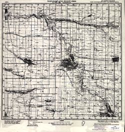
- Description:
- 1925
- Subject:
- Topical Subject: Maps, Topical Subject: Soviet Union, and Geographic Subject: Yegorlykskaya
- Publisher:
- Генеральный штаб Красной Армии
- Language:
- Russian
- Date Created:
- 1941
- Identifier:
- VAC9619-002324
- Genre:
- Topographic Maps and Military Maps
- Geographic Location:
- Coordinates: 46.3333, 40.5, 46.6667, 41
- Related URL:
- Download GeoTIFF: https://drive.google.com/file/d/1Vno5pFrXmYsLk7cNSrTkoNPk8hjwCPIL/view?usp=sharing and Catalog URL: https://iucat.iu.edu/catalog/5020129
- Abstract:
- Modern area represented: Yegorlykskaya, Russia
- Call Number:
- G7000 s100 .S7 sheet L-37-58
- Caption:
- Для служебного пользования
- City:
- Егорлыкская (Yegorlykskaya)
- Copyright Holder:
- No Copyright - United States
- Country:
- СССР (USSR)
- State/Province:
- РСФСР (RSFSR) and Ростовская область (Rostov oblast)
- Physical Description:
- Scale: 1:100,000
- Persistent URL:
- http://purl.dlib.indiana.edu/iudl/images/VAC9619/VAC9619-002324
- Provenance:
- DMA Topographic Center, Library of Congress Geography & Map Division
-
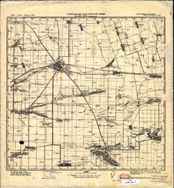
- Description:
- 1926
- Subject:
- Topical Subject: Maps, Geographic Subject: Salsk, and Topical Subject: Soviet Union
- Publisher:
- Генеральный штаб Красной Армии
- Language:
- Russian
- Date Created:
- 1941
- Identifier:
- VAC9619-002326
- Genre:
- Military Maps and Topographic Maps
- Geographic Location:
- Coordinates: 46.3333, 41.5, 46.6667, 42
- Related URL:
- Catalog URL: https://iucat.iu.edu/catalog/5020129 and Download GeoTIFF: https://drive.google.com/file/d/1PArZEQhSATe1EKVgUDFtZ3ICldn22WR5/view?usp=sharing
- Abstract:
- Modern area represented: Salsk, Russia
- Call Number:
- G7000 s100 .S7 sheet L-37-60
- Caption:
- Для служебного пользования
- City:
- Сальск (Salsk)
- Copyright Holder:
- No Copyright - United States
- Country:
- СССР (USSR)
- State/Province:
- Ростовская область (Rostov oblast) and РСФСР (RSFSR)
- Physical Description:
- Scale: 1:100,000
- Persistent URL:
- http://purl.dlib.indiana.edu/iudl/images/VAC9619/VAC9619-002326
- Provenance:
- CIA Map Library, Heeresplankammer Gruppe Archive Auslandskartenarchiv
