
Search Constraints
You searched for:
Publisher
Генеральный штаб Красной Армии
Remove constraint Publisher: Генеральный штаб Красной Армии
« Previous |
1 - 20 of 1,420
|
Next »
Search Results
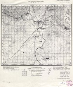
-
- Description:
- 1912
- Subject:
- Topical Subject: Soviet Union, Topical Subject: Maps, and Geographic Subject: Maku
- Publisher:
- Генеральный штаб Красной Армии
- Language:
- Russian
- Date Created:
- 1941
- Identifier:
- VAC9619-000117
- Genre:
- Military Maps and Topographic Maps
- Geographic Location:
- Coordinates: 39, 44.5, 39.3333, 45
- Related URL:
- Catalog URL: https://iucat.iu.edu/catalog/5020129 and Download GeoTIFF: https://drive.google.com/open?id=1yxUNfH1eBFr_XPjkGSrP0UxUjoeZAI1s
- Abstract:
- Modern area represented: Maku, West Azerbaijan province, Iran
- Call Number:
- G7000 s100 .S7 sheet J-38-30
- Caption:
- Для служебного пользования
- City:
- Маку (Maku)
- Copyright Holder:
- No Copyright - United States
- Country:
- Иран (Iran)
- Physical Description:
- Scale: 1:100,000
- Persistent URL:
- http://purl.dlib.indiana.edu/iudl/images/VAC9619/VAC9619-000117
- Provenance:
- DMA Topographic Center, Army Map Service Library, OMAHA, Library of Congress Geography & Map Division
-
- Description:
- 1911
- Subject:
- Topical Subject: Maps, Geographic Subject: Nakhichivan, and Topical Subject: Soviet Union
- Publisher:
- Генеральный штаб Красной Армии
- Language:
- Russian
- Date Created:
- 1941
- Identifier:
- VAC9619-000168
- Genre:
- Topographic Maps and Military Maps
- Geographic Location:
- Coordinates: 39, 45, 39.3333, 45.5
- Related URL:
- Download GeoTIFF: https://drive.google.com/open?id=1h5_S_6_AlNlCJetMeL_sUoTO5Fdurz2q and Catalog URL: https://iucat.iu.edu/catalog/5020129
- Abstract:
- Modern area represented: Nakhichivan, Nakhchivan autonomous republic, Azerbaijan
- Call Number:
- G7000 s100 .S7 sheet J-38-31
- Caption:
- Для служебного пользования
- City:
- Нахичевань (Nakhichivan)
- Copyright Holder:
- No Copyright - United States
- Country:
- Иран (Iran)
- State/Province:
- Нахичеванская АССР (Nakhichevan Autonomous Soviet Socialist Republic)
- Physical Description:
- Scale: 1:100,000
- Persistent URL:
- http://purl.dlib.indiana.edu/iudl/images/VAC9619/VAC9619-000168
- Provenance:
- Army Map Service Library, Library of Congress G & M Division, Geographic Names Branch
-
- Description:
- 1912
- Subject:
- Topical Subject: Soviet Union and Topical Subject: Maps
- Publisher:
- Генеральный штаб Красной Армии
- Language:
- Russian
- Date Created:
- 1941
- Identifier:
- VAC9619-000169
- Genre:
- Topographic Maps and Military Maps
- Geographic Location:
- Coordinates: 38.6667, 44.5, 39, 45
- Related URL:
- Catalog URL: https://iucat.iu.edu/catalog/5020129 and Download GeoTIFF: https://drive.google.com/file/d/1FXM5g0j66ZiEmcLy926Au1ZaXEYYVLlY/view?usp=sharing
- Call Number:
- G7000 s100 .S7 sheet J-38-42
- Caption:
- Для служебного пользования
- City:
- Хыдырлы (Khydyrly)
- Copyright Holder:
- No Copyright - United States
- Country:
- Иран (Iran)
- Physical Description:
- Scale: 1:100,000
- Persistent URL:
- http://purl.dlib.indiana.edu/iudl/images/VAC9619/VAC9619-000169
- Provenance:
- Army Map Service Library, Library of Congress G & M Division, Geographic Names Branch
-
- Description:
- 1912
- Subject:
- Topical Subject: Maps, Topical Subject: Soviet Union, and Geographic Subject: Īvowghlī
- Publisher:
- Генеральный штаб Красной Армии
- Language:
- Russian
- Date Created:
- 1941
- Identifier:
- VAC9619-001041
- Genre:
- Military Maps and Topographic Maps
- Geographic Location:
- Coordinates: 38.6667, 45, 39, 45.5
- Related URL:
- Catalog URL: https://iucat.iu.edu/catalog/5020129 and Download GeoTIFF: https://drive.google.com/open?id=1qpvW4RsmwJh6m1WiJtJXW567d8q67ACe
- Abstract:
- Modern area represented: Īvowghlī, West Azerbaijan province, Iran
- Call Number:
- G7000 s100 .S7 sheet J-38-43
- Caption:
- Для служебного пользования
- City:
- Евоглю (Evoghlu)
- Copyright Holder:
- No Copyright - United States
- Country:
- СССР (USSR) and Иран (Iran)
- State/Province:
- Нахичеванская АССР (Nakhichevan Autonomous Soviet Socialist Republic)
- Physical Description:
- Scale: 1:100,000
- Persistent URL:
- http://purl.dlib.indiana.edu/iudl/images/VAC9619/VAC9619-001041
- Provenance:
- DMA Topographic Center, Army Map Service Library, Library of Congress Geography & Map Division, OMAHA
-
- Description:
- 1910
- Subject:
- Topical Subject: Maps, Topical Subject: Soviet Union, and Geographic Subject: Culfa
- Publisher:
- Генеральный штаб Красной Армии
- Language:
- Russian
- Date Created:
- 1941
- Identifier:
- VAC9619-000702
- Genre:
- Topographic Maps and Military Maps
- Geographic Location:
- Coordinates: 38.6667, 45.5, 39, 46
- Related URL:
- Catalog URL: https://iucat.iu.edu/catalog/5020129 and Download GeoTIFF: https://drive.google.com/open?id=1ciMiII6qDnnJ6WZV49dwofar2Sm3RRBF
- Abstract:
- Modern area represented: Culfa, Nakhchivan Autonomous Republic, Azerbaijan
- Call Number:
- G7000 s100 .S7 sheet J-38-44
- Caption:
- Временное издание,Для служебного пользования
- City:
- Джульфа (Culfa)
- Copyright Holder:
- No Copyright - United States
- Country:
- Иран (Iran)
- State/Province:
- Нахичеванская АССР (Nakhichevan Autonomous Soviet Socialist Republic)
- Physical Description:
- Scale: 1:100,000
- Persistent URL:
- http://purl.dlib.indiana.edu/iudl/images/VAC9619/VAC9619-000702
- Provenance:
- DMA Topographic Center, Army Map Service Library, OMAHA, Library of Congress Geography & Map Division
-
- Subject:
- Topical Subject: Maps, Topical Subject: Soviet Union, and Geographic Subject: Julfa
- Publisher:
- Генеральный штаб Красной Армии
- Language:
- Russian
- Date Created:
- 1940
- Identifier:
- VAC9619-000089
- Genre:
- Topographic Maps and Military Maps
- Geographic Location:
- Coordinates: 38.8333, 45.5, 39, 45.75
- Related URL:
- Download GeoTIFF: https://drive.google.com/open?id=1fZhMoeilfY5E-PsoYnAeUMHJQW6GUmXx and Catalog URL: http://iucat.iu.edu/catalog/5020131
- Abstract:
- Modern area represented: Julfa, Azerbaijan
- Call Number:
- G7000 s50 .S68 sheet J-38-44-A
- Caption:
- Не подлежит оглашению
- City:
- Джульфа (Dzhulfa)
- Copyright Holder:
- No Copyright - United States
- Country:
- Иран (Iran) and СССР (USSR)
- State/Province:
- Нахичеванская АССР (Nakhichevan Autonomous Soviet Socialist Republic)
- Physical Description:
- Scale: 1:50,000
- Persistent URL:
- http://purl.dlib.indiana.edu/iudl/images/VAC9619/VAC9619-000089
- Provenance:
- CIA Map Library
-
- Description:
- 1911
- Subject:
- Topical Subject: Soviet Union, Topical Subject: Maps, and Geographic Subject: Ordubad
- Publisher:
- Генеральный штаб Красной Армии
- Language:
- Russian
- Date Created:
- 1941
- Identifier:
- VAC9619-000887
- Genre:
- Topographic Maps and Military Maps
- Geographic Location:
- Coordinates: 38.6667, 46, 39, 46.5
- Related URL:
- Download GeoTIFF: https://drive.google.com/open?id=1QEhyrdUoV08U5oUYl5odXPXyNlonu_lh and Catalog URL: https://iucat.iu.edu/catalog/5020129
- Abstract:
- Modern area represented: Ordubad, Nakhchivan Autonomous Republic, Azerbaijan
- Call Number:
- G7000 s100 .S7 sheet J-38-45
- Caption:
- Временное издание,Для служебного пользования
- City:
- Ордубад (Ordubad)
- Copyright Holder:
- No Copyright - United States
- Country:
- Иран (Iran)
- State/Province:
- Нахичеванская АССР (Nakhichevan Autonomous Soviet Socialist Republic) and Армянская ССР (Armenian Soviet Socialist Republic)
- Physical Description:
- Scale: 1:100,000
- Persistent URL:
- http://purl.dlib.indiana.edu/iudl/images/VAC9619/VAC9619-000887
- Provenance:
- DMA Topographic Center, Army Map Service Library, OMAHA, Library of Congress Geography & Map Division, Auswärtiges Amt. Geographischer Dienst
-
- Description:
- 1912
- Subject:
- Topical Subject: Maps, Geographic Subject: Valdīān, and Topical Subject: Soviet Union
- Publisher:
- Генеральный штаб Красной Армии
- Language:
- Russian
- Date Created:
- 1941
- Identifier:
- VAC9619-001037
- Genre:
- Topographic Maps and Military Maps
- Geographic Location:
- Coordinates: 38.3333, 45, 38.6667, 45.5
- Related URL:
- Catalog URL: https://iucat.iu.edu/catalog/5020129 and Download GeoTIFF: https://drive.google.com/open?id=172i-zN6WhR7vbpKdGdU37qsjCP5LflAk
- Abstract:
- Modern area represented: Valdīān, West Azerbaijan, Iran
- Call Number:
- G7000 s100 .S7 sheet J-38-55
- Caption:
- Для служебного пользования
- City:
- Валдиан (Valdīān)
- Copyright Holder:
- No Copyright - United States
- Country:
- Иран (Iran)
- Physical Description:
- Scale: 1:100,000
- Persistent URL:
- http://purl.dlib.indiana.edu/iudl/images/VAC9619/VAC9619-001037
- Provenance:
- Army Map Service Library, Library of Congress G & M Division, Geographic Names Branch
-
- Description:
- 1912
- Subject:
- Geographic Subject: Anderyān, Topical Subject: Soviet Union, and Topical Subject: Maps
- Publisher:
- Генеральный штаб Красной Армии
- Language:
- Russian
- Date Created:
- 1941
- Identifier:
- VAC9619-000902
- Genre:
- Military Maps and Topographic Maps
- Geographic Location:
- Coordinates: 38.3333, 46, 38.6667, 46.5
- Related URL:
- Download GeoTIFF: https://drive.google.com/open?id=1k0PqIMTiLBMqIzYfFeLhXaA2eT4gzNX1 and Catalog URL: https://iucat.iu.edu/catalog/5020129
- Abstract:
- Modern area represented: Anderyān, East Azerbaijan, Iran
- Call Number:
- G7000 s100 .S7 sheet J-38-57
- Caption:
- Временное издание
- City:
- Андырджан (Andergan)
- Copyright Holder:
- No Copyright - United States
- Country:
- Иран (Iran)
- Physical Description:
- Scale: 1:100,000
- Persistent URL:
- http://purl.dlib.indiana.edu/iudl/images/VAC9619/VAC9619-000902
- Provenance:
- DMA Topographic Center, Army Map Service Library, OMAHA, Library of Congress Geography & Map Division, Auswärtiges Amt. Geographischer Dienst
-
- Description:
- 1912
- Subject:
- Topical Subject: Maps, Geographic Subject: Tasūj, and Topical Subject: Soviet Union
- Publisher:
- Генеральный штаб Красной Армии
- Language:
- Russian
- Date Created:
- 1941
- Identifier:
- VAC9619-001140
- Genre:
- Topographic Maps and Military Maps
- Geographic Location:
- Coordinates: 38, 45, 38.3333, 45.5
- Related URL:
- Catalog URL: https://iucat.iu.edu/catalog/5020129 and Download GeoTIFF: https://drive.google.com/open?id=1i7JKA676OI5ZuPLGFgPkMrLVZjELVDcx
- Abstract:
- Modern area represented: Tasūj, East Azerbaijan, Iran
- Call Number:
- G7000 s100 .S7 sheet J-38-67
- Caption:
- Для служебного пользования
- City:
- Тасвич (Tasvich)
- Copyright Holder:
- No Copyright - United States
- Country:
- Иран (Iran)
- Physical Description:
- Scale: 1:100,000
- Persistent URL:
- http://purl.dlib.indiana.edu/iudl/images/VAC9619/VAC9619-001140
- Provenance:
- Army Map Service Library, Geographic Names Branch
-
- Description:
- 1909
- Subject:
- Topical Subject: Soviet Union, Geographic Subject: Shabestar, and Topical Subject: Maps
- Publisher:
- Генеральный штаб Красной Армии
- Language:
- Russian
- Date Created:
- 1941
- Identifier:
- VAC9619-001115
- Genre:
- Military Maps and Topographic Maps
- Geographic Location:
- Coordinates: 38, 45.5, 38.3333, 46
- Related URL:
- Catalog URL: https://iucat.iu.edu/catalog/5020129 and Download GeoTIFF: https://drive.google.com/open?id=1W80M4FLMU0wN1-htAcYwssKPeWQeg0hq
- Abstract:
- Modern area represented: Shabestar, East Azerbaijan, Iran
- Call Number:
- G7000 s100 .S7 sheet J-38-68
- Caption:
- Временное издание
- City:
- Чабиастар (Shabestar)
- Copyright Holder:
- No Copyright - United States
- Country:
- Иран (Iran)
- Physical Description:
- Scale: 1:100,000
- Persistent URL:
- http://purl.dlib.indiana.edu/iudl/images/VAC9619/VAC9619-001115
- Provenance:
- DMA Topographic Center, Army Map Service Library, OMAHA, Library of Congress Geography & Map Division
-
- Description:
- 1905
- Subject:
- Topical Subject: Maps, Topical Subject: Soviet Union, and Geographic Subject: Lazarevskoye
- Publisher:
- Генеральный штаб Красной Армии
- Language:
- Russian
- Date Created:
- 1942
- Identifier:
- VAC9619-000759
- Genre:
- Topographic Maps and Military Maps
- Geographic Location:
- Coordinates: 43.6667, 39, 44, 39.5
- Related URL:
- Catalog URL: https://iucat.iu.edu/catalog/5020129 and Download GeoTIFF: https://drive.google.com/open?id=1OcoSmUSM2ZO6HwjSl9T2sxJaHo8Fbzui
- Abstract:
- Modern area represented: Lazarevskoye, Krasnodar kray, Russia
- Call Number:
- G7000 s100 .S7 sheet K-37-7
- Caption:
- Для служебного пользования
- City:
- Лазаревская (Lazarevskoye)
- Copyright Holder:
- No Copyright - United States
- Country:
- СССР (USSR)
- State/Province:
- Краснодарская область (Krasnodar oblast) and РСФСР (RSFSR)
- Physical Description:
- Scale: 1:100,000
- Persistent URL:
- http://purl.dlib.indiana.edu/iudl/images/VAC9619/VAC9619-000759
- Provenance:
- CIA Map Library
-
- Description:
- 1903
- Subject:
- Geographic Subject: Detlyazhka, Topical Subject: Maps, and Topical Subject: Soviet Union
- Publisher:
- Генеральный штаб Красной Армии
- Language:
- Russian
- Identifier:
- VAC9619-000752
- Genre:
- Military Maps and Topographic Maps
- Geographic Location:
- Coordinates: 39.5, 43.6667, 40, 44
- Related URL:
- Download GeoTIFF: https://drive.google.com/open?id=1diaa3kPb__e1IZYQ7bRW53NrZIWTa3bv and Catalog URL: https://iucat.iu.edu/catalog/5020129
- Abstract:
- Modern area represented: Detlyazhka, Krasnodar kray, Russia
- Call Number:
- G7000 s100 .S7 sheet K-37-8
- Caption:
- Для служебного пользования
- Copyright Holder:
- No Copyright - United States
- Country:
- СССР (USSR)
- State/Province:
- Краснодарский край (Krasnodar kray) and РСФСР (RSFSR)
- Physical Description:
- Scale: 1:100,000
- Persistent URL:
- http://purl.dlib.indiana.edu/iudl/images/VAC9619/VAC9619-000752
- Provenance:
- CIA Map Library, Atlasblatt
-
- Subject:
- Topical Subject: Maps, Geographic Subject: Aleksandriyskaya, and Topical Subject: Soviet Union
- Publisher:
- Генеральный штаб Красной Армии
- Language:
- Russian
- Identifier:
- VAC9619-000813
- Genre:
- Topographic Maps and Military Maps
- Related URL:
- Catalog URL: https://iucat.iu.edu/catalog/5020129
- Abstract:
- Modern area represented: Aleksandriyskaya, Dagestan republic, Russia
- Call Number:
- G7000 s100 .S7 sheet K-38-11
- Copyright Holder:
- No Copyright - United States
- Country:
- СССР (USSR)
- Physical Description:
- Scale: 1:100,000
- Persistent URL:
- http://purl.dlib.indiana.edu/iudl/images/VAC9619/VAC9619-000813
- Provenance:
- CIA Map Library
-
- Description:
- 1886
- Subject:
- Topical Subject: Maps, Topical Subject: Soviet Union, and Geographic Subject: Zayukovo
- Publisher:
- Генеральный штаб Красной Армии
- Language:
- Russian
- Date Created:
- 1942
- Identifier:
- VAC9619-000768
- Genre:
- Military Maps and Topographic Maps
- Geographic Location:
- Coordinates: 43.3333, 43, 43.6667, 43.5
- Related URL:
- Download GeoTIFF: https://drive.google.com/open?id=1ZvJc3OHAg6vpcikjFr92BMG60irdKLJA and Catalog URL: https://iucat.iu.edu/catalog/5020129
- Abstract:
- Modern area represented: Zayukovo, Kabardino-Balkariya Republic, Russia
- Call Number:
- G7000 s100 .S7 sheet K-38-15
- Caption:
- Для служебного пользования
- City:
- Заюково (Zayukovo)
- Copyright Holder:
- No Copyright - United States
- Country:
- СССР (USSR)
- State/Province:
- РСФСР (RSFSR) and Кабардино-Балкарская АССР (Kabardino-Balkar Autonomous Soviet Socialist Republic)
- Physical Description:
- Scale: 1:100,000
- Persistent URL:
- http://purl.dlib.indiana.edu/iudl/images/VAC9619/VAC9619-000768
- Provenance:
- DMA Topographic Center, Army Map Service Library, Library of Congress Geography & Map Division
-
- Description:
- 1941
- Subject:
- Geographic Subject: Babayurt, Topical Subject: Maps, and Topical Subject: Soviet Union
- Publisher:
- Генеральный штаб Красной Армии
- Language:
- Russian
- Date Created:
- 1942
- Identifier:
- VAC9619-000784
- Genre:
- Topographic Maps and Military Maps
- Geographic Location:
- Coordinates: 43.3333, 46.5, 43.6667, 47
- Related URL:
- Download GeoTIFF: https://drive.google.com/open?id=1J0-KZD89YETRBJk8JXDeJgXjmkM-Bz0H and Catalog URL: https://iucat.iu.edu/catalog/5020129
- Abstract:
- Modern area represented: Babayurt, Dagestan republic, Russia
- Call Number:
- G7000 s100 .S7 sheet K-38-22
- Caption:
- Для служебного пользования
- City:
- Баба-Юрт (Baba-Yurt)
- Copyright Holder:
- No Copyright - United States
- Country:
- СССР (USSR)
- State/Province:
- Дагестанская АССР (Dagestan Autonomous Soviet Socialist Republic) and РСФСР (RSFSR)
- Physical Description:
- Scale: 1:100,000
- Persistent URL:
- http://purl.dlib.indiana.edu/iudl/images/VAC9619/VAC9619-000784
- Provenance:
- CIA Map Library, Atlasblatt
-
- Description:
- 1870
- Subject:
- Topical Subject: Soviet Union, Topical Subject: Maps, and Geographic Subject: Alagir
- Publisher:
- Генеральный штаб Красной Армии
- Language:
- Russian
- Date Created:
- 1942
- Identifier:
- VAC9619-000786
- Genre:
- Topographic Maps and Military Maps
- Geographic Location:
- Coordinates: 43, 44, 43.3333, 44.5
- Related URL:
- Download GeoTIFF: https://drive.google.com/open?id=1ipwxw4RfPnMQCVYN2bZCXjRGnhJRTiAZ and Catalog URL: https://iucat.iu.edu/catalog/5020129
- Abstract:
- Modern area represented: Alagir, North Ossetia – Alania republic, Russia
- Call Number:
- G7000 s100 .S7 sheet K-38-29
- Caption:
- Для служебного пользования
- City:
- Алагир (Alagir)
- Copyright Holder:
- No Copyright - United States
- Country:
- СССР (USSR)
- State/Province:
- Северо-Осетинская АССР (North Ossetian Autonomous Soviet Socialist Republic), Кабардино-Балкарская АССР (Kabardino-Balkar Autonomous Soviet Socialist Republi...
- Physical Description:
- Scale: 1:100,000
- Persistent URL:
- http://purl.dlib.indiana.edu/iudl/images/VAC9619/VAC9619-000786
- Provenance:
- Army Map Service Library, Geographic Names Branch, Library of Congress G & M Division
-
- Description:
- 1910
- Subject:
- Topical Subject: Soviet Union, Topical Subject: Maps, and Geographic Subject: Malka
- Publisher:
- Генеральный штаб Красной Армии
- Language:
- Russian
- Date Created:
- 1942
- Identifier:
- VAC9619-000774
- Genre:
- Topographic Maps and Military Maps
- Geographic Location:
- Coordinates: 43.6667, 43, 44, 43.5
- Related URL:
- Download GeoTIFF: https://drive.google.com/open?id=1SGbNvHRjKc5EerPHr8nhRF6X8xaL-QxT and Catalog URL: https://iucat.iu.edu/catalog/5020129
- Abstract:
- Modern area represented: Malka, Kabardino-Balkariya republic, Russia
- Call Number:
- G7000 s100 .S7 sheet K-38-3
- Caption:
- Для служебного пользования
- City:
- Малка (Malka)
- Copyright Holder:
- No Copyright - United States
- Country:
- СССР (USSR)
- State/Province:
- РСФСР (RSFSR), Кабардино-Балкарская АССР (Kabardino-Balkar Autonomous Soviet Socialist Republic), and Орджоникидзевский край (Ordzhonikidze kray)
- Physical Description:
- Scale: 1:100,000
- Persistent URL:
- http://purl.dlib.indiana.edu/iudl/images/VAC9619/VAC9619-000774
- Provenance:
- Army Map Service Library, Geographic Names Branch, Library of Congress G & M Division
-
- Description:
- 1865
- Subject:
- Geographic Subject: Vladikavkaz, Topical Subject: Soviet Union, and Topical Subject: Maps
- Publisher:
- Генеральный штаб Красной Армии
- Language:
- Russian
- Date Created:
- 1942
- Identifier:
- VAC9619-000771
- Genre:
- Military Maps and Topographic Maps
- Geographic Location:
- Coordinates: 43, 44.5, 43.3333, 45
- Related URL:
- Catalog URL: https://iucat.iu.edu/catalog/5020129 and Download GeoTIFF: https://drive.google.com/open?id=1kDKKODnPr23wD5i0h8neJQlTz_2AADEd
- Abstract:
- Modern area represented: Vladikavkaz, North Ossetia, Russia
- Call Number:
- G7000 s100 .S7 sheet K-38-30
- Caption:
- Для служебного пользования
- City:
- Орджоникидзе (Ordzhonikidze)
- Copyright Holder:
- No Copyright - United States
- Country:
- СССР (USSR)
- State/Province:
- Северо-Осетинская АССР (North Ossetian Autonomous Soviet Socialist Republic), Чечено-Ингушская АССР (Checheno-Ingush Autonomous Soviet Socialist Republic), a...
- Physical Description:
- Scale: 1:100,000
- Persistent URL:
- http://purl.dlib.indiana.edu/iudl/images/VAC9619/VAC9619-000771
- Provenance:
- DMA Topographic Center, Army Map Service Library, Library of Congress Geography & Map Division
-
- Description:
- 1941
- Subject:
- Topical Subject: Soviet Union, Geographic Subject: Sulak, and Topical Subject: Maps
- Publisher:
- Генеральный штаб Красной Армии
- Language:
- Russian
- Date Created:
- 1942
- Identifier:
- VAC9619-000823
- Genre:
- Topographic Maps and Military Maps
- Geographic Location:
- Coordinates: 43.1667, 47.5, 43.3333, 47.75
- Related URL:
- Download GeoTIFF: https://drive.google.com/open?id=1fi0Y7Zx7hJENqk7HaR288XcwIYbzqak_ and Catalog URL: https://iucat.iu.edu/catalog/5020129
- Abstract:
- Modern area represented: Sulak, Dagestan republic, Russia
- Call Number:
- G7000 s100 .S7 sheet K-38-36
- Caption:
- Для служебного пользования
- City:
- Главный Сулак (Glavniy Sulak)
- Copyright Holder:
- No Copyright - United States
- Country:
- СССР (USSR)
- State/Province:
- Дагестанская АССР (Dagestan Autonomous Soviet Socialist Republic) and РСФСР (RSFSR)
- Physical Description:
- Scale: 1:100,000
- Persistent URL:
- http://purl.dlib.indiana.edu/iudl/images/VAC9619/VAC9619-000823
- Provenance:
- DMA Topographic Center, Atlasblatt, Library of Congress Geography & Map Division, Army Map Service Library
