
Search Constraints
You searched for:
State/Province
РСФСР (RSFSR)
Remove constraint State/Province: РСФСР (RSFSR)
« Previous |
1 - 20 of 1,385
|
Next »
Search Results
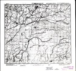
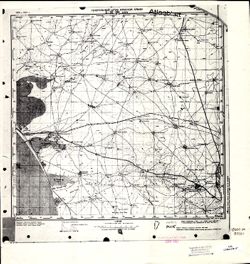
-
- Description:
- 1905
- Subject:
- Topical Subject: Maps, Topical Subject: Soviet Union, and Geographic Subject: Lazarevskoye
- Publisher:
- Генеральный штаб Красной Армии
- Language:
- Russian
- Date Created:
- 1942
- Identifier:
- VAC9619-000759
- Genre:
- Topographic Maps and Military Maps
- Geographic Location:
- Coordinates: 43.6667, 39, 44, 39.5
- Related URL:
- Catalog URL: https://iucat.iu.edu/catalog/5020129 and Download GeoTIFF: https://drive.google.com/open?id=1OcoSmUSM2ZO6HwjSl9T2sxJaHo8Fbzui
- Abstract:
- Modern area represented: Lazarevskoye, Krasnodar kray, Russia
- Call Number:
- G7000 s100 .S7 sheet K-37-7
- Caption:
- Для служебного пользования
- City:
- Лазаревская (Lazarevskoye)
- Copyright Holder:
- No Copyright - United States
- Country:
- СССР (USSR)
- State/Province:
- Краснодарская область (Krasnodar oblast) and РСФСР (RSFSR)
- Physical Description:
- Scale: 1:100,000
- Persistent URL:
- http://purl.dlib.indiana.edu/iudl/images/VAC9619/VAC9619-000759
- Provenance:
- CIA Map Library
-
- Description:
- 1903
- Subject:
- Geographic Subject: Detlyazhka, Topical Subject: Maps, and Topical Subject: Soviet Union
- Publisher:
- Генеральный штаб Красной Армии
- Language:
- Russian
- Identifier:
- VAC9619-000752
- Genre:
- Military Maps and Topographic Maps
- Geographic Location:
- Coordinates: 39.5, 43.6667, 40, 44
- Related URL:
- Download GeoTIFF: https://drive.google.com/open?id=1diaa3kPb__e1IZYQ7bRW53NrZIWTa3bv and Catalog URL: https://iucat.iu.edu/catalog/5020129
- Abstract:
- Modern area represented: Detlyazhka, Krasnodar kray, Russia
- Call Number:
- G7000 s100 .S7 sheet K-37-8
- Caption:
- Для служебного пользования
- Copyright Holder:
- No Copyright - United States
- Country:
- СССР (USSR)
- State/Province:
- Краснодарский край (Krasnodar kray) and РСФСР (RSFSR)
- Physical Description:
- Scale: 1:100,000
- Persistent URL:
- http://purl.dlib.indiana.edu/iudl/images/VAC9619/VAC9619-000752
- Provenance:
- CIA Map Library, Atlasblatt
-
- Description:
- 1908
- Subject:
- Topical Subject: Soviet Union, Geographic Subject: Dzheguta, and Topical Subject: Maps
- Publisher:
- НКЗ СССР Сельхозаэросъемка
- Language:
- Russian
- Date Created:
- 1941
- Identifier:
- VAC9619-000718
- Genre:
- Topographic Maps and Military Maps
- Geographic Location:
- Coordinates: 43.6667, 42, 44, 42.5
- Related URL:
- Catalog URL: https://iucat.iu.edu/catalog/5020129 and Download GeoTIFF: https://drive.google.com/open?id=1kp0kGErywYJdw2pwrWDo3C-X9cu0C8Xk
- Abstract:
- Modern area represented: Dzheguta, Karachayevo-Cherkesiya Republic, Russia
- Call Number:
- G7000 s100 .S7 sheet K-38-1
- Caption:
- Временное издание,Для служебного пользования
- City:
- Джегутинский (Dzhegutinskiy)
- Copyright Holder:
- No Copyright - United States
- Country:
- СССР (USSR)
- State/Province:
- Орджоникидзевский край (Ordzhonikidze kray) and РСФСР (RSFSR)
- Physical Description:
- Scale: 1:100,000
- Persistent URL:
- http://purl.dlib.indiana.edu/iudl/images/VAC9619/VAC9619-000718
- Provenance:
- DMA Topographic Center, Army Map Service Library, OMAHA, Library of Congress Geography & Map Division
-
- Description:
- 1887
- Subject:
- Topical Subject: Maps, Geographic Subject: Mount Elbrus, and Topical Subject: Soviet Union
- Publisher:
- Государственный Бальнеологический Институт Н.К. ЗДР. СССР
- Language:
- Russian
- Date Created:
- 1934
- Identifier:
- VAC9619-000779
- Genre:
- Topographic Maps and Military Maps
- Geographic Location:
- Coordinates: 43.3333, 42, 43.6667, 42.5
- Related URL:
- Catalog URL: https://iucat.iu.edu/catalog/5020129 and Download GeoTIFF: https://drive.google.com/open?id=1uvQ6jHUyvIoUP4Kx8w2Gk5OM3HIpqFa6
- Abstract:
- Modern area represented: Mount Elbrus, Kabardino-Balkariya Republic, Russia
- Call Number:
- G7000 s100 .S7 sheet K-38-13
- City:
- Г.Эльбрус (Mount Elbrus)
- Copyright Holder:
- No Copyright - United States
- Country:
- СССР (USSR)
- State/Province:
- Кабардино-Балкарская АССР (Kabardino-Balkar Autonomous Soviet Socialist Republic), Карачаевская автономная область (Karachay Autonomous Oblast), and РСФСР (R...
- Physical Description:
- Scale: 1:100,000
- Persistent URL:
- http://purl.dlib.indiana.edu/iudl/images/VAC9619/VAC9619-000779
- Provenance:
- Army Map Service Library, Atlasblatt, Library of Congress G & M Division
-
- Description:
- 1886
- Subject:
- Topical Subject: Maps, Topical Subject: Soviet Union, and Geographic Subject: Zayukovo
- Publisher:
- Генеральный штаб Красной Армии
- Language:
- Russian
- Date Created:
- 1942
- Identifier:
- VAC9619-000768
- Genre:
- Military Maps and Topographic Maps
- Geographic Location:
- Coordinates: 43.3333, 43, 43.6667, 43.5
- Related URL:
- Download GeoTIFF: https://drive.google.com/open?id=1ZvJc3OHAg6vpcikjFr92BMG60irdKLJA and Catalog URL: https://iucat.iu.edu/catalog/5020129
- Abstract:
- Modern area represented: Zayukovo, Kabardino-Balkariya Republic, Russia
- Call Number:
- G7000 s100 .S7 sheet K-38-15
- Caption:
- Для служебного пользования
- City:
- Заюково (Zayukovo)
- Copyright Holder:
- No Copyright - United States
- Country:
- СССР (USSR)
- State/Province:
- РСФСР (RSFSR) and Кабардино-Балкарская АССР (Kabardino-Balkar Autonomous Soviet Socialist Republic)
- Physical Description:
- Scale: 1:100,000
- Persistent URL:
- http://purl.dlib.indiana.edu/iudl/images/VAC9619/VAC9619-000768
- Provenance:
- DMA Topographic Center, Army Map Service Library, Library of Congress Geography & Map Division
-
- Description:
- 1908
- Subject:
- Geographic Subject: Kislovodsk, Topical Subject: Soviet Union, and Topical Subject: Maps
- Publisher:
- НКЗ СССР Сельхозаэросъемка
- Language:
- Russian
- Date Created:
- 1941
- Identifier:
- VAC9619-000730
- Genre:
- Military Maps and Topographic Maps
- Geographic Location:
- Coordinates: 43.6667, 42.5, 44, 43
- Related URL:
- Catalog URL: https://iucat.iu.edu/catalog/5020129 and Download GeoTIFF: https://drive.google.com/open?id=1hE8Lj11I3DMGaxuNgdEk19cXKHishQi_
- Abstract:
- Modern area represented: Kislovodsk, Stavropol kray, Russia
- Call Number:
- G7000 s100 .S7 sheet K-38-2
- Caption:
- Для служебного пользования
- City:
- Кисловодск (Kislovodsk)
- Copyright Holder:
- No Copyright - United States
- Country:
- СССР (USSR)
- State/Province:
- Карачаевская автономная область (Karachay Autonomous Oblast), Орджоникидзевский край (Ordzhonikidze kray), РСФСР (RSFSR), and Кабардино-Балкарская АССР (Kaba...
- Physical Description:
- Scale: 1:100,000
- Persistent URL:
- http://purl.dlib.indiana.edu/iudl/images/VAC9619/VAC9619-000730
- Provenance:
- DMA Topographic Center, Atlasblatt, Army Map Service Library, Library of Congress Geography & Map Division, OMAHA
-
- Description:
- 1941
- Subject:
- Geographic Subject: Babayurt, Topical Subject: Maps, and Topical Subject: Soviet Union
- Publisher:
- Генеральный штаб Красной Армии
- Language:
- Russian
- Date Created:
- 1942
- Identifier:
- VAC9619-000784
- Genre:
- Topographic Maps and Military Maps
- Geographic Location:
- Coordinates: 43.3333, 46.5, 43.6667, 47
- Related URL:
- Download GeoTIFF: https://drive.google.com/open?id=1J0-KZD89YETRBJk8JXDeJgXjmkM-Bz0H and Catalog URL: https://iucat.iu.edu/catalog/5020129
- Abstract:
- Modern area represented: Babayurt, Dagestan republic, Russia
- Call Number:
- G7000 s100 .S7 sheet K-38-22
- Caption:
- Для служебного пользования
- City:
- Баба-Юрт (Baba-Yurt)
- Copyright Holder:
- No Copyright - United States
- Country:
- СССР (USSR)
- State/Province:
- Дагестанская АССР (Dagestan Autonomous Soviet Socialist Republic) and РСФСР (RSFSR)
- Physical Description:
- Scale: 1:100,000
- Persistent URL:
- http://purl.dlib.indiana.edu/iudl/images/VAC9619/VAC9619-000784
- Provenance:
- CIA Map Library, Atlasblatt
-
- Description:
- 1870
- Subject:
- Topical Subject: Soviet Union, Topical Subject: Maps, and Geographic Subject: Alagir
- Publisher:
- Генеральный штаб Красной Армии
- Language:
- Russian
- Date Created:
- 1942
- Identifier:
- VAC9619-000786
- Genre:
- Topographic Maps and Military Maps
- Geographic Location:
- Coordinates: 43, 44, 43.3333, 44.5
- Related URL:
- Download GeoTIFF: https://drive.google.com/open?id=1ipwxw4RfPnMQCVYN2bZCXjRGnhJRTiAZ and Catalog URL: https://iucat.iu.edu/catalog/5020129
- Abstract:
- Modern area represented: Alagir, North Ossetia – Alania republic, Russia
- Call Number:
- G7000 s100 .S7 sheet K-38-29
- Caption:
- Для служебного пользования
- City:
- Алагир (Alagir)
- Copyright Holder:
- No Copyright - United States
- Country:
- СССР (USSR)
- State/Province:
- Северо-Осетинская АССР (North Ossetian Autonomous Soviet Socialist Republic), Кабардино-Балкарская АССР (Kabardino-Balkar Autonomous Soviet Socialist Republi...
- Physical Description:
- Scale: 1:100,000
- Persistent URL:
- http://purl.dlib.indiana.edu/iudl/images/VAC9619/VAC9619-000786
- Provenance:
- Army Map Service Library, Geographic Names Branch, Library of Congress G & M Division
-
- Description:
- 1910
- Subject:
- Topical Subject: Soviet Union, Topical Subject: Maps, and Geographic Subject: Malka
- Publisher:
- Генеральный штаб Красной Армии
- Language:
- Russian
- Date Created:
- 1942
- Identifier:
- VAC9619-000774
- Genre:
- Topographic Maps and Military Maps
- Geographic Location:
- Coordinates: 43.6667, 43, 44, 43.5
- Related URL:
- Download GeoTIFF: https://drive.google.com/open?id=1SGbNvHRjKc5EerPHr8nhRF6X8xaL-QxT and Catalog URL: https://iucat.iu.edu/catalog/5020129
- Abstract:
- Modern area represented: Malka, Kabardino-Balkariya republic, Russia
- Call Number:
- G7000 s100 .S7 sheet K-38-3
- Caption:
- Для служебного пользования
- City:
- Малка (Malka)
- Copyright Holder:
- No Copyright - United States
- Country:
- СССР (USSR)
- State/Province:
- РСФСР (RSFSR), Кабардино-Балкарская АССР (Kabardino-Balkar Autonomous Soviet Socialist Republic), and Орджоникидзевский край (Ordzhonikidze kray)
- Physical Description:
- Scale: 1:100,000
- Persistent URL:
- http://purl.dlib.indiana.edu/iudl/images/VAC9619/VAC9619-000774
- Provenance:
- Army Map Service Library, Geographic Names Branch, Library of Congress G & M Division
-
- Description:
- 1865
- Subject:
- Geographic Subject: Vladikavkaz, Topical Subject: Soviet Union, and Topical Subject: Maps
- Publisher:
- Генеральный штаб Красной Армии
- Language:
- Russian
- Date Created:
- 1942
- Identifier:
- VAC9619-000771
- Genre:
- Military Maps and Topographic Maps
- Geographic Location:
- Coordinates: 43, 44.5, 43.3333, 45
- Related URL:
- Catalog URL: https://iucat.iu.edu/catalog/5020129 and Download GeoTIFF: https://drive.google.com/open?id=1kDKKODnPr23wD5i0h8neJQlTz_2AADEd
- Abstract:
- Modern area represented: Vladikavkaz, North Ossetia, Russia
- Call Number:
- G7000 s100 .S7 sheet K-38-30
- Caption:
- Для служебного пользования
- City:
- Орджоникидзе (Ordzhonikidze)
- Copyright Holder:
- No Copyright - United States
- Country:
- СССР (USSR)
- State/Province:
- Северо-Осетинская АССР (North Ossetian Autonomous Soviet Socialist Republic), Чечено-Ингушская АССР (Checheno-Ingush Autonomous Soviet Socialist Republic), a...
- Physical Description:
- Scale: 1:100,000
- Persistent URL:
- http://purl.dlib.indiana.edu/iudl/images/VAC9619/VAC9619-000771
- Provenance:
- DMA Topographic Center, Army Map Service Library, Library of Congress Geography & Map Division
-
- Description:
- 1941
- Subject:
- Topical Subject: Soviet Union, Geographic Subject: Sulak, and Topical Subject: Maps
- Publisher:
- Генеральный штаб Красной Армии
- Language:
- Russian
- Date Created:
- 1942
- Identifier:
- VAC9619-000823
- Genre:
- Topographic Maps and Military Maps
- Geographic Location:
- Coordinates: 43.1667, 47.5, 43.3333, 47.75
- Related URL:
- Download GeoTIFF: https://drive.google.com/open?id=1fi0Y7Zx7hJENqk7HaR288XcwIYbzqak_ and Catalog URL: https://iucat.iu.edu/catalog/5020129
- Abstract:
- Modern area represented: Sulak, Dagestan republic, Russia
- Call Number:
- G7000 s100 .S7 sheet K-38-36
- Caption:
- Для служебного пользования
- City:
- Главный Сулак (Glavniy Sulak)
- Copyright Holder:
- No Copyright - United States
- Country:
- СССР (USSR)
- State/Province:
- Дагестанская АССР (Dagestan Autonomous Soviet Socialist Republic) and РСФСР (RSFSR)
- Physical Description:
- Scale: 1:100,000
- Persistent URL:
- http://purl.dlib.indiana.edu/iudl/images/VAC9619/VAC9619-000823
- Provenance:
- DMA Topographic Center, Atlasblatt, Library of Congress Geography & Map Division, Army Map Service Library
-
- Description:
- 1926
- Subject:
- Geographic Subject: Petropavlovskiy, Topical Subject: Soviet Union, and Topical Subject: Maps
- Publisher:
- Генеральный штаб Красной Армии
- Language:
- Russian
- Date Created:
- 1942
- Identifier:
- VAC9619-000776
- Genre:
- Military Maps and Topographic Maps
- Geographic Location:
- Coordinates: 43.6667, 43.5, 44, 44
- Related URL:
- Catalog URL: https://iucat.iu.edu/catalog/5020129 and Download GeoTIFF: https://drive.google.com/open?id=1dg7f6EBuVklTPJaZtvCy_PTDJEXMZyd5
- Abstract:
- Modern area represented: Petropavlovskiy, Kabardino-Balkariya republic, Russia
- Call Number:
- G7000 s100 .S7 sheet K-38-4
- Caption:
- Для служебного пользования
- City:
- Новопавловская (Petropavlovskaya)
- Copyright Holder:
- No Copyright - United States
- Country:
- СССР (USSR)
- State/Province:
- Орджоникидзевский край (Ordzhonikidze kray), Кабардино-Балкарская АССР (Kabardino-Balkar Autonomous Soviet Socialist Republic), and РСФСР (RSFSR)
- Physical Description:
- Scale: 1:100,000
- Persistent URL:
- http://purl.dlib.indiana.edu/iudl/images/VAC9619/VAC9619-000776
- Provenance:
- DMA Topographic Center, Army Map Service Library, Library of Congress Geography & Map Division
-
- Description:
- 1925
- Subject:
- Topical Subject: Maps, Geographic Subject: Prokhladniy, and Topical Subject: Soviet Union
- Publisher:
- Генеральный штаб Красной Армии
- Language:
- Russian
- Date Created:
- 1942
- Identifier:
- VAC9619-000808
- Genre:
- Topographic Maps and Military Maps
- Geographic Location:
- Coordinates: 43.6667, 44, 44, 44.5
- Related URL:
- Download GeoTIFF: https://drive.google.com/open?id=1OjKt08J0_fPt0XbJ57tpvB64eHbCRPc1 and Catalog URL: https://iucat.iu.edu/catalog/5020129
- Abstract:
- Modern area represented: Prokhladniy, Kabardino-Balkariya republic, Russia
- Call Number:
- G7000 s100 .S7 sheet K-38-5
- Caption:
- Секретно
- City:
- Прохладный (Prokhladniy)
- Copyright Holder:
- No Copyright - United States
- Country:
- СССР (USSR)
- State/Province:
- Орджоникидзевский край (Ordzhonikidze kray), РСФСР (RSFSR), and Кабардино-Балкарская АССР (Kabardino-Balkar Autonomous Soviet Socialist Republic)
- Physical Description:
- Scale: 1:100,000
- Persistent URL:
- http://purl.dlib.indiana.edu/iudl/images/VAC9619/VAC9619-000808
- Provenance:
- DMA Topographic Center, Army Map Service Library, Library of Congress Geography & Map Division
-
- Description:
- 1927
- Subject:
- Topical Subject: Soviet Union, Geographic Subject: Mozdok, and Topical Subject: Maps
- Publisher:
- Генеральный штаб Красной Армии
- Language:
- Russian
- Date Created:
- 1942
- Identifier:
- VAC9619-000781
- Genre:
- Military Maps and Topographic Maps
- Geographic Location:
- Coordinates: 43.6667, 44.5, 44, 45
- Related URL:
- Download GeoTIFF: https://drive.google.com/open?id=1r1SWyJiKpjKXCDKEQG6P9Qc-RYOZ5cX_ and Catalog URL: https://iucat.iu.edu/catalog/5020129
- Abstract:
- Modern area represented: Mozdok, North Ossetia – Alania republic, Russia
- Call Number:
- G7000 s100 .S7 sheet K-38-6
- Caption:
- Для служебного пользования
- City:
- Моздок (Mozdok)
- Copyright Holder:
- No Copyright - United States
- Country:
- СССР (USSR)
- State/Province:
- Орджоникидзевский край (Ordzhonikidze kray), Кабардино-Балкарская АССР (Kabardino-Balkar Autonomous Soviet Socialist Republic), РСФСР (RSFSR), and Чечено-Инг...
- Physical Description:
- Scale: 1:100,000
- Persistent URL:
- http://purl.dlib.indiana.edu/iudl/images/VAC9619/VAC9619-000781
- Provenance:
- Army Map Service Library, Geographic Names Branch, Library of Congress G & M Division
-
- Description:
- 1928
- Subject:
- Geographic Subject: Ishcherskaya, Topical Subject: Maps, and Topical Subject: Soviet Union
- Publisher:
- Генеральный штаб Красной Армии
- Language:
- Russian
- Date Created:
- 1942
- Identifier:
- VAC9619-000713
- Genre:
- Military Maps and Topographic Maps
- Geographic Location:
- Coordinates: 43.6667, 45, 44, 45.5
- Related URL:
- Catalog URL: https://iucat.iu.edu/catalog/5020129 and Download GeoTIFF: https://drive.google.com/open?id=1FvJwKmJFKaVdSLxaBo8WClBaKfF26Pxc
- Abstract:
- Modern area represented: Ishcherskaya, Chechnya, Russia
- Call Number:
- G7000 s100 .S7 sheet K-38-7
- Caption:
- Для служебного пользования
- City:
- Ищерская (Ishcherskaya)
- Copyright Holder:
- No Copyright - United States
- Country:
- СССР (USSR)
- State/Province:
- Орджоникидзевский край (Ordzhonikidze kray), Чечено-Ингушская АССР (Checheno-Ingush Autonomous Soviet Socialist Republic), and РСФСР (RSFSR)
- Physical Description:
- Scale: 1:100,000
- Persistent URL:
- http://purl.dlib.indiana.edu/iudl/images/VAC9619/VAC9619-000713
- Provenance:
- Army Map Service Library, Geographic Names Branch, Library of Congress G & M Division
-
- Description:
- 1906
- Subject:
- Geographic Subject: Hunchun, Topical Subject: Soviet Union, and Topical Subject: Maps
- Publisher:
- Управление военных топографов РККА
- Language:
- Russian
- Date Created:
- 1933
- Identifier:
- VAC9619-000914
- Genre:
- Topographic Maps and Military Maps
- Geographic Location:
- Coordinates: 42.6667, 130, 43, 130.5
- Related URL:
- Download GeoTIFF: https://drive.google.com/open?id=14YXbAZgngEEXJeyyh0_6PJ45RyfdxAgg and Catalog URL: https://iucat.iu.edu/catalog/5020129
- Abstract:
- Modern area represented: Hunchun, Jilin province, China
- Call Number:
- G7000 s100 .S7 sheet K-52-45
- Caption:
- Не подлежит оглашению
- City:
- Хунчун (Hunchun)
- Copyright Holder:
- No Copyright - United States
- Country:
- СССР (USSR) and Корея (Korea)
- State/Province:
- Дальневосточный край (Far Eastern kray), Маньчжурия (Manchuria), and РСФСР (RSFSR)
- Physical Description:
- Scale: 1:100,000
- Persistent URL:
- http://purl.dlib.indiana.edu/iudl/images/VAC9619/VAC9619-000914
- Provenance:
- DMA Topographic Center, Army Map Service Library, OMAHA, Library of Congress Geography & Map Division
-
- Description:
- 1935
- Subject:
- Topical Subject: Soviet Union, Topical Subject: Maps, and Geographic Subject: Sergeyevka
- Publisher:
- Управление военных топографов РККА
- Language:
- Russian
- Identifier:
- VAC9619-000822
- Genre:
- Military Maps and Topographic Maps
- Geographic Location:
- Coordinates: 43.3333, 133, 43.6667, 133.5
- Related URL:
- Download GeoTIFF: https://drive.google.com/open?id=1CRxpKntUT0SQjGYFGsZAgqrl0lOMN9eg and Catalog URL: https://iucat.iu.edu/catalog/5020129
- Abstract:
- Modern area represented: Sergeyevka, Primorskiy (Maritime) kray, Russia
- Call Number:
- G7000 s100 .S7 sheet K-53-15
- Caption:
- Не подлежит оглашению
- City:
- Сергеевка (Sergeyevka)
- Copyright Holder:
- No Copyright - United States
- Country:
- СССР (USSR)
- State/Province:
- РСФСР (RSFSR) and Дальневосточный край (Far Eastern kray)
- Physical Description:
- Scale: 1:100,000
- Persistent URL:
- http://purl.dlib.indiana.edu/iudl/images/VAC9619/VAC9619-000822
- Provenance:
- DMA Topographic Center, Library of Congress G & M Division, Army Map Service Library, Atlasblatt
-
- Description:
- 1913
- Subject:
- Topical Subject: Maps, Topical Subject: Soviet Union, and Geographic Subject: Partizansk
- Publisher:
- Управление военных топографов РККА
- Language:
- Russian
- Date Created:
- 1934
- Identifier:
- VAC9619-000811
- Genre:
- Topographic Maps and Military Maps
- Geographic Location:
- Coordinates: 43, 133, 43.3333, 133.5
- Related URL:
- Catalog URL: https://iucat.iu.edu/catalog/5020129 and Download GeoTIFF: https://drive.google.com/open?id=1R7GQuqPSC31N6DmuMyrjjbi0qENHsXFB
- Abstract:
- Modern area represented: Partizansk, Primorskiy (Maritime) kray, Russia
- Call Number:
- G7000 s100 .S7 sheet K-53-27
- Caption:
- Не подлежит оглашению
- City:
- Сучан (Suchan)
- Copyright Holder:
- No Copyright - United States
- Country:
- СССР (USSR)
- State/Province:
- РСФСР (RSFSR) and Дальневосточный край (Far Eastern kray)
- Physical Description:
- Scale: 1:100,000
- Persistent URL:
- http://purl.dlib.indiana.edu/iudl/images/VAC9619/VAC9619-000811
- Provenance:
- DMA Topographic Center, Army Map Service Library, Library of Congress Geography & Map Division, Atlasblatt
-
- Description:
- 1895
- Subject:
- Topical Subject: Maps, Topical Subject: Soviet Union, Geographic Subject: Republic of Crimea, and Geographic Subject: Yevpatoriya
- Publisher:
- Генеральный штаб Красной Армии
- Language:
- Russian
- Date Created:
- 1941
- Identifier:
- VAC9619-001955
- Genre:
- Topographic Maps and Military Maps
- Geographic Location:
- Coordinates: 45, 33, 45.3333, 33.5
- Related URL:
- Download GeoTIFF: https://drive.google.com/open?id=1BtkwQn0L-XQPkON9n_c9ainj7EtEYvHh and Catalog URL: https://iucat.iu.edu/catalog/5020129
- Abstract:
- Modern area represented: Евпатория (Yevpatoriya), Republic of Crimea, Ukraine
- Call Number:
- G7000 s100 .S7 sheet L-36-103
- Caption:
- Для служебного пользования
- City:
- Евпатория (Yevpatoriya)
- Copyright Holder:
- No Copyright - United States
- Country:
- СССР (USSR)
- State/Province:
- РСФСР (RSFSR) and Крымская АССР (Crimean Autonomous Soviet Socialist Republic)
- Physical Description:
- Scale: 1:100,000
- Persistent URL:
- http://purl.dlib.indiana.edu/iudl/images/VAC9619/VAC9619-001955
- Provenance:
- DMA Topographic Center, OMAHA
-
- Description:
- 1895
- Subject:
- Geographic Subject: Republic of Crimea, Geographic Subject: Saki, Topical Subject: Soviet Union, and Topical Subject: Maps
- Publisher:
- Генеральный штаб Красной Армии
- Language:
- Russian
- Date Created:
- 1941
- Identifier:
- VAC9619-001956
- Genre:
- Topographic Maps and Military Maps
- Geographic Location:
- Coordinates: 45, 33.5, 45.3333, 34
- Related URL:
- Download GeoTIFF: https://drive.google.com/open?id=1KeZQMnq0svWW8sbbr2gRu_IXfdHE5Zod and Catalog URL: https://iucat.iu.edu/catalog/5020129
- Abstract:
- Modern area represented: Саки (Saki), Republic of Crimea, Ukraine
- Call Number:
- G7000 s100 .S7 sheet L-36-104
- Caption:
- Для cлужебного пользования
- City:
- Саки (Saki)
- Copyright Holder:
- No Copyright - United States
- Country:
- СССР (USSR)
- State/Province:
- РСФСР (RSFSR)
- Physical Description:
- Scale: 1:100,000
- Persistent URL:
- http://purl.dlib.indiana.edu/iudl/images/VAC9619/VAC9619-001956
- Provenance:
- CIA Map Library
